
-
 3210 Hits
-
 76.66% Score
-
 7 Votes
|
|
Mountain/Rock |
|---|---|
|
|
42.80130°N / 103.61113°W |
|
|
Sioux |
|
|
Hiking |
|
|
4785 ft / 1458 m |
|
|
Overview
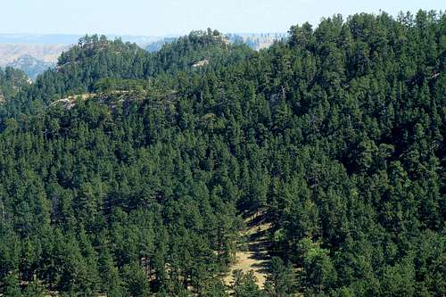
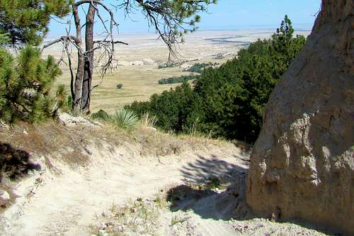 Trailview on Eagles Eye
Have you ever wanted to get away from it all? Find yourself a million miles from civilization? Be in the rugged outback? Or feel what the old west was like? Most people say they would, yet would go stir crazy when the realization that the chance for companionship or the nearest shopping is hundreds of miles away. What if you could have the chance for rugged solitude during your vacation?
If you are in the Pine Ridge of remote northwest Nebraska and looking for a good hike with some great views, Eagles Eye Rock is worth your consideration. Though it is among Nebraska’s 25 highest named summits, Eagles Eye Rock has limited prominence, due to a few higher un-named ridge high points a few miles west (a problem that is inherent in most of the Pine Ridge region’s summits) . However, there is approximately 585 feet of rise when you hike in from Milo Road, hence the opportunities for those great views. Most hikers will find this to be a relatively easy to moderate hike.
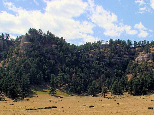
 Eagles Eye Rock Summit Area
This summit route is entirely on public land, though the National Forest Service office in Chadron will caution hikers to stay on the old FSR route because of nearby private land. You may also find on certain occasions that the area is restricted when the forest service is doing work in the area or there has been another forest fire. It never hurts to call the forest service to be sure. The major forest fire that swept the area in 2012 caused access to the summit to be restricted for a long time. The next year Winter Storm Atlas added additional damage to the area. The forest service always cautions anyone venturing into one of these old burn areas to be aware of the serious potential for injury or death due to “snags”, that is dead trees that can fall unexpectedly, even in non-windy conditions. Plans are underway to re-forest the area.
Nearby attractions include Big Cottonwood Canyon at Toadstool Geologic Park, Roundtop Peak, Wright Peak or a visit to the famous High Plains Homestead and Sand Creek Cookhouse, in a rugged “Old West” setting. Other places to visit in this region include Fort Robinson, just 3 miles west of Crawford, which offers many miles of trails, canyons and named summits to visit, plus great camping and lodging facilities. Also, Soldier Creek Wilderness borders Fort Robinson on the west. And who could forget the Black Hills, just an hour’s drive to the north?
Eagles Eye Rock commands a sweeping view to the north, east and south. To the northwest, Roundtop Peak and Pine Butte are clearly visible. To the east are badlands, while some forest remnants and numerous small un-named peaks lie to the south. This is a somewhat remote summit that normally does not see a great deal of traffic, so there will be a good chance that you will have the whole route to yourself. Do not count on good cell service here. It seems to be “spotty” at best. Of course, this all means that you should not count on outside assistance if you run into problems. So please take these things into consideration when you make your plans.
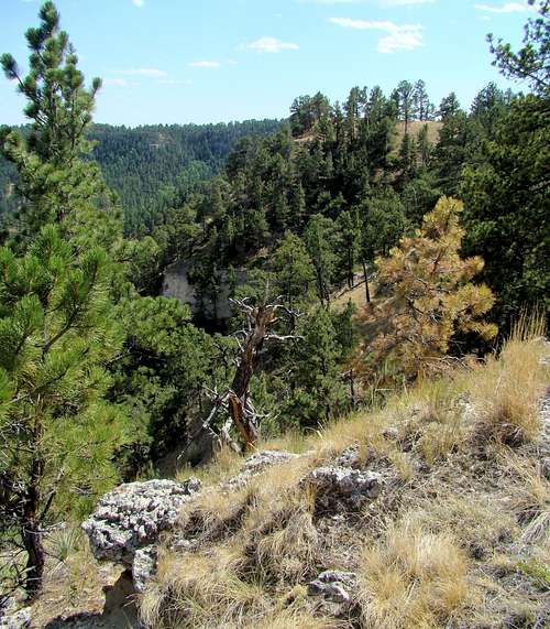
 Eagles Eye Before 2012 Fire
Like so many summits in the area, Eagles Eye Rock has numerous small outcroppings of what is locally called “butte rock”, which is a mixture of sandstone, limestone, volcanic ash and clay. Though significant portions of the Ponderosa pine forest on and around Eagles Eye have been burned, some forest still remains. Cactus and yucca (called soap weed by Native Americans in times past) flourishes in this semi-arid region. The area abounds in deer, pronghorn antelope and elk. Occasional mountain lions and coyotes are also sometimes seen. Because of a large wild turkey population in the area, fall hunting season sees numerous hunters. The terrain offers great habitat for snakes, so be on the alert for rattlesnakes (unless you are doing a winter hike.) Ticks are abundant in the Pine Ridge region, so please be prepared.
Getting There
To reach Eagles Eye Rock from Crawford, Nebraska, travel north on Highway 2/71. The Toadstool Road turnoff is about 5 miles north, and is well-marked. It goes straight west for two miles then turns north to northwest. About nine miles from the highway is the turnoff road for the Hudson-Meng archeological site, and is shown on many maps as Sand Creek Road, which passes by the High Plains Homestead / Sand Creek Cook House area, about 4 miles from the Toadstool Road. About one mile past Sand Creek Cook House, there is a junction with Milo Road. Turn south and travel about one mile to Forest Service Road 945 (which is not well-marked and is easy to miss). If the forest service has the road closed, you will have to park and hike up from there. Otherwise, if you wish you may take your 4-wheel drive to the base and hike up from there.
Route
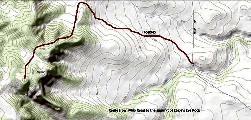 Eagles Eye Rock Trail Map
The route from Mile Road to the summit is very simple. Hikers will need to follow old FSR945, which is about 1.5 miles from Milo Road to the summit area, with a 585 foot rise. If you 4-wheel in to the base of the rock, it is about .7 mile to the summit, with a 365 foot rise. The map on this page will give you a view of that route. There is no cairn or geodetic marker at the summit, which is somewhat level, so you will have to use your GPS if finding the exact highpoint is part of your goal.
Additional map resources are available at these links:
Red Tape
This whole area around Eagles Eye is managed by the Nebraska National Forest Service office in Chadron, NE. Normally, there are no restrictions for hiking. Because of very serious forest fires in past years, the “no campfires and no fireworks” regulations are strictly enforced. Hikers who desire to contact them may do so by calling (308) 432-0300. Their website is located at:
When to Climb
Weather conditions will affect your trip to the summit of Eagles Eye Rock. Summer hail and lightning, as well as winter blizzards will no doubt inspire you to seek a better time. Hunting seasons can bring its own kind of hazards also. If you hike during hunting season, please wear plenty of orange!
Weather for the Eagles Eye Rock area
Nebraska Hunting Season Information
Camping & Lodging
 Eagles Eye Summit View South
The National Forest Service allows primitive camping on forest service land, but with some restrictions. You can check those out at this link:
National Forest Primitive Camping Regulations
Camping is available at nearby Toadstool Geologic Park. Self-pay stations are located there. There are vault toilets, but no showers or running water – you must pack in your own water. The nearest camping elsewhere would be in Crawford, 19 miles away, and at Fort Robinson, 3 miles west of Crawford. There is also some lodging just a few miles away at the High Plains Homestead - very rustic in a frontier theme. The Sand Creek Cook House is the closest place to get an excellent meal. For more information on these, click on any of the links below:
High Plains Homestead & Sand Creek Cook House
Fort Robinson Camping & Lodging
Soldier Creek Wilderness Camping