
-
 7224 Hits
-
 83.17% Score
-
 17 Votes
|
|
Mountain/Rock |
|---|---|
|
|
42.72000°N / 103.05°W |
|
|
Dawes |
|
|
Hiking |
|
|
Spring, Summer, Fall, Winter |
|
|
4236 ft / 1291 m |
|
|
Overview
 Flannigan Butte East Side 2016
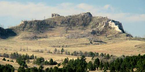
Flannigan Butte is a fun hike for anyone who wants a 3-to-5 mile hike with some incline and scrambling to go with it, plus panoramic views of the surrounding area. It commands a splendid view of the Black Hills 50 miles to the north and an assortment of Pine Ridge buttes, canyons, and ridges in every other direction. The butte is characterized by steep sides most of the way around, with numerous rocky cliffs providing obstacles and challenges for hikers bushwhacking their way to the summit.
 Flannigan Butte's south side before the fire
While the forest on Flannigan Butte was mostly destroyed in the great fires of 2012, nature is slowly healing the land now. Many of the dead trees have fallen off and eventually the snag dangers will become minimal. Fortunately for hikers and climbers, the forest was thin enough in key places before the fire that there are some reasonably safe routes to the summit. For now, forest service officials still caution hikers and climbers about the dangers of falling trees and recommend finding routes that go around the thickest dead tree areas. The hike to Flannigan Butte takes one through small sections of forest, through small ravines, and over lots of open pasture land. Though much of the forest has burned, there is still an abundance of wildlife in the area, including large numbers of deer and wild turkeys. Bighorn sheep are seen in this area sometimes too. Chadron State Park is Flannigan Butte’s neighbor to the southeast and features many good hiking trails plus some great camping opportunities there. This area of the national forest is also a favorite of area horseback riders and it is not uncommon to encounter them while hiking. It is also a popular area during hunting seasons.
Getting There
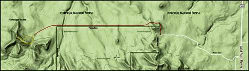
To get to the highway turnoff for hiking to Flannigan Butte, go south from Chadron 7.5 miles on Highway 385. There will be an old west-bound road on the right with few markings. But, the road almost immediately splits, with the left branch going to the nearby farm. The right branch is labeled 739 and goes up a hill in a westerly direction. US Forest Service maps show the road going through their section marked 24A.
Route Information
 Flannigan Butte Hiking Route
There is no official trailhead, even though Flannigan Butte is on public land. So, hikers must either hike or drive a mile from the highway to a private property fence line and gate. If they have not received permission to use the mile-long two-track roadway through the private property to the other side, they will have to go a few hundred yards north along the fence to where it turns and goes straight west. Hikers can then follow the fence for one mile, at which point they will be less than one-half mile from the butte. At that point, the hike is pretty much an off-trail hike, but easy to make your own route up. Before the fire, the east side was a good side to hike up, though rather steep. Now it is covered with fallen dead timber. But there are a few places where there is little timber and a scramble through those places to the upper ridge is probably the best bet. The routes marked in yellow on the map are two suggestions. The west side of Flannigan is quite sheer and offers little or no safe access for hikers. If hiking from the highway, the elevation gain is about 450 feet over the 2.5-mile route. The hike from the private property fence line gains about 360 feet over approximately 1.5 miles, dependent of course on how you choose your bushwhack route up from the base of the butte.
Red Tape
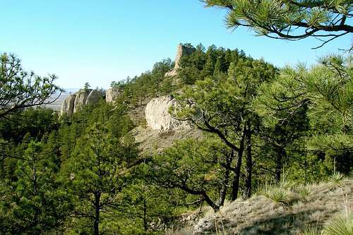
 Summit View West
 Summit Geodetic Marker
If you choose to use all public lands for your route to the summit of Flannigan Butte, there should be no red tape. If you are interested in a more direct route to Flannigan Butte and want to try to get permission from the property owner who owns the continuation of the roadway begun by forest road 739 and where public access ends at the fence line, you should contact the forest service office for the latest contact information. You can reach them at (308) 432-0300. In times past, the property owner has been favorable to allowing some hikers to hike the property, provided they close the gates. Please keep in mind though, that access could be lost in the future if the privilege is not respected.
Hiking & Climbing Safety
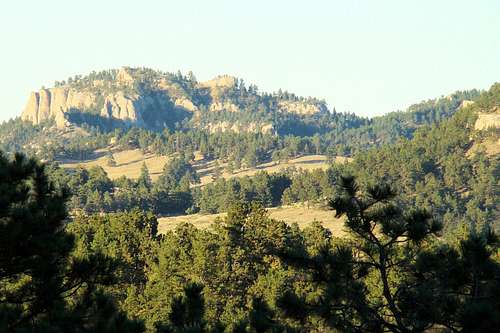
 Flannigan Butte Fire Damage
 Flannigan Butte Before The Fire
Ticks are abundant in this region from early March through August. Rattlesnakes are occasionally seen in the area. Mountain lions are also in the region, but rarely seen. Should you choose to attempt to climb a rock face, please bear in mind the soft and unstable nature of the rock base of the butte. Summer lightning and hail, as well as winter blizzards and ice warrant keeping up-to-date with weather forecasts and conditions. You can check those out at this link: Flannigan Butte – Chadron Area Weather Forecast & Conditions Hunting seasons can create risks to hikers also. For more information on area hunting in Nebraska, click on this link: Nebraska Hunting Seasons Information
Camping, Lodging & Resource Links
 Flannigan Butte Evening Shadows
Chadron State Park has great facilities for tenters, trailers, and motor homes, plus cabins and dorms for rent. They also have a swimming pool, tennis courts, fishing, hiking trails, and horseback riding. You can reach the park office at: (308) 432-6167 or you can access their website at: Chadron State Park Nearby Chadron offers lodging, meals, supplies, and a National Forest Service office. You can reach their visitors center by phone at (308) 432-4401 or you can access their website at: Chadron Nebraska Visitors Center Backcountry camping is allowed in parts of the Nebraska National Forest. For more information, you can call the forest service headquarters in Chadron at (308) 432-0300 or you can access their website at: National Forest Backcountry Camping