
|
|
Route |
|---|---|
|
|
39.16170°N / 106.5518°W |
|
|
scramble |
|
|
Most of a day |
|
|
class 3 |
|
|
Approach
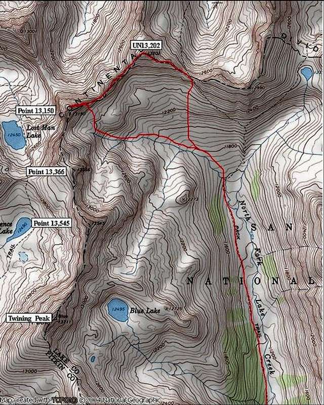
Round Trip-8 miles and 2,900-ft
With only 8 miles 2,900-ft, this climb makes for a great half-day excursion. If you’re fast you can get both points in less than 6 hours.
From the parking area at 10,828-ft, cross North Fork Lake Creek and locate the TH. Take this fast trail north 2.5 miles and 780-ft to a wide open tundra-ridden basin at 11,570-ft. Locate Point 12,990-ft directly in front of you. The pyramid shaped UN13,202 is just to the left of Point 12,990-ft. The USGS Champion Quad shows a trail that runs straight up the south ridge of Point 12,990. The Quad also shows the trail splitting and traversing to a saddle just east of UN13,202. I couldn’t locate any of this trail. Don’t waste your time tying to locate it. It’s an easy hike up into the basin below UN13,202.
From 11,570-ft the trail will cross the creek to the east side. Do not cross. Instead, leave the trail and hike directly up into the nice basin east of Twining Peak and south of UN13,202. Locate the saddle just east of UN13,202 and hike up the steep slope to a saddle which is also the ridge crest of UN13,202’s east ridge.
Route Description
From here, the climbing is as difficult as you want to make it. Staying on the ridge crest will get you into some really fun class 3 scrambling.
Ascend UN13,202’s east ridge over a few false summits to about 12,900-ft. From here the summit is protected by a huge summit block. This block is very imposing and requires a traverse on an exposed grass ledge around to the direct south face of the block. From here it is class 2+ to the summit of UN13,202. Locating the ledge is key to the route.
I highly recommend continuing to Point 13,150. The intense scrambling up the east ridge of 13,150 is the most difficult of the day. Also, be aware that the north face of Point 13,150 is a cold and dark place. You will have to do some exposed slab climbing here. I’m betting that these slabs will be covered in ice and snow for a lot of the year. So only attempt this route in the dead of summer.
Descend the easy west ridge of UN13,202 and continue to a saddle at 12,750 which is at the base of Point 13,150’s east ridge. Staying on the ridge crest, pick your way up through the rough ridge. A few large germdarms reside here. You can climb a few of them however one or two need to be carefully traversed on the north side of the ridge. Soon you will get a good view of the final summit block across a steep north facing and exposed slab. Traverse this slab to the base of the block. Next carefully pick your way of a very loose gully that splits the northeast face which leads to the summit. Be careful here, the route doesn’t get climbed often, so there is plenty of loose stuff to deal with.
Descend your ascent route back down the loose gully and make your way back to the saddle at 12,750. You can leave the saddle here and drop south, back down into the grassy basin. From here it’s an easy hike back to the trail at 10,570-ft.