-
 9167 Hits
-
 79.78% Score
-
 11 Votes
|
|
Route |
|---|---|
|
|
43.78831°N / 110.76791°W |
|
|
Mountaineering, Scrambling |
|
|
Summer |
|
|
Scrambling and easy/moderate snow |
|
|
Class 3 |
|
|
Overview
Of the routes on Rockchuck Peak, this one is the easiest and the most direct. That does not mean it is easy, though. Although the Bonney guide puts it at Class 3 and it in fact can be kept that way, unless it is late summer of a dry year, there is almost certainly going to be some snow work as well, mostly in the easy range but drifting into moderate in places. Unless you can see from the road that the route is snow-free, and you can see the entire route from the Cathedral Group turnout, don't leave the ice axe behind when you do this one. I didn't need or even have my crampons when I used this route, but they might be necessary earlier in the summer.So in other words, this is not the typical Class 3 route, with a lot of walking and a few spots of scrambling. Experienced climbers will have no trouble with this route, but others will find it more challenging, especially as it gets closer to the top and the terrain becomes steeper and more difficult.
Getting There
Just before the road becomes one-way-only as it skirts Jenny Lake, take the well-signed spur for String Lake and park at the String Lake TH.Route Description
One-way distance is about 3.5 miles, with approximately 4400' of elevation gain. The first 1.5 mi is by trail and gains only about 100'. Yeah, it's a steep route. It's the Tetons, after all; that vertical rise from the floor of Jackson Hole is one of the Earth's greatest sights, but it's not one of its greatest things to climb.From the trailhead, hike south and then around the west side of String Lake. Once on the west side, you should, according to Bonney, hike about 20 minutes to some "huge boulders W of trail." This is a little vague, as the largest boulders in the vicinity are actually east of the trail, but I have a picture below showing some large boulders where you should leave the trail. The other picture below shows the gully you have to approach, and that gully is plainly visible from the trail. So it's pretty hard not to find this route.
 |
 |
In case the second picture above isn't clear enough, head for an open drainage just north (right) of the E-W ridge running parallel to Mount St. John and Rockchuck Peak; this is actually the east ridge of Rockchuck, but don't take any notions of climbing the ridge just yet (more below).
Stick to the north (right) side of the drainage-- the other side is forested-- until you reach a broader basin above. From there on, the easier ground tends to be on the south (left) side of the stream, though that is not exclusively so. Thus, although it is a Class 3 route and can stay that way on the rock, you should not be surprised to run into Class 4 ground. If it gets harder than that, and it easily can, retreat and look for something else.
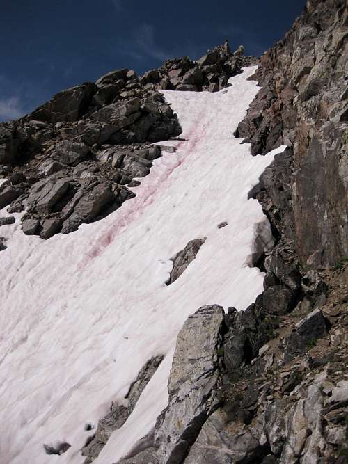
Reminder: Snow is likely on this route. In August 2011, I had to negotiate three significant snowfields and the short cliff bands between. An ice axe was sufficient for me then, but earlier in the season, crampons might be necessary as well.
As you ascend, you will notice that ridge on your left more and more. Again, this is the east ridge of Rockchuck Peak. As tempting as it might seem to gain the ridge and use it to reach the summit, you don't really want to do this until you are much higher. The ridge has some pinnacles on it that may not be overly difficult to negotiate (I don't know because I didn't try them) but will at the very least slow you down and create more work, including more overall elevation gain.
Instead, wait until you are past those pinnacles and then scramble to the crest of the ridge, follow it to its junction with the summit pyramid, and then head left a short distance to each the highpoint.
 |
 |
 |
Note: You may see a steep, snow-filled couloir seeming to lead directly to the summit. This couloir looked way too steep for a glissade on the way back down, and I chose not to climb it because it seemed that crampons would be needed, and mine had been left behind. If you want to climb this couloir, I strongly recommend using crampons and wouldn't be surprised if it is steep enough to require more technical gear than that.