![The east slope of Hard Butte...]() Southeast bowl of Hard Butte
Southeast bowl of Hard Butte
I got up early and left home at 5 AM, which got me to the Clayburn trailhead by 8 AM. It was a beautiful brisk morning with some high clouds and winds that while not much of a concern at the moment were forecast to increase throughout the day. It appeared this could be the last day of nice fall weather and I intended to use it to bag one of the peaks on my list. The goal for the day was Hard Butte, which is one of the higher peaks in the Grassy Mountains, which are the westernmost subrange of the extensive Salmon River Mountains.
![Hard Butte]() Southeast side
Southeast side![The north face of Hard Butte...]() Northeast side
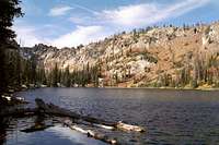
Northeast side![Upper Twin Lake is the middle...]() Upper Twin Lake
Upper Twin Lake![The route climbs the north...]() Hard Butte Lake
Hard Butte Lake![The north bowl of Hard Butte....]() Upper cove
Upper cove![The old lookout on the summit...]() Old Lookout
Old Lookout![This is the typical terrain...]() Southeast slope
Southeast slope![This is the basin above...]() Basin above Rainbow Lake
Basin above Rainbow Lake![This is the south side of the...]() South side of NE ridge
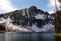
South side of NE ridge![Rainbow Lake]() Rainbow Lake
Rainbow Lake
The first part of my route was easy to follow on a large trail that is used by livestock and ATVs, though despite hiking in these mountains on several occasions, I have yet to see either. I wasn’t sure what I would find nearing the mountain because of discrepancies among the various maps I had looked at while planning the trip. To start I made good time hiking the level three miles to Warm Springs Saddle, which is the site of the major trail junction in the area. One map showed a trail ascending the northeast ridge of the mountain and continuing on to the summit. Another map showed no trail at all. I did find a trail going approximately in that direction, but soon it became apparent it was going into the lake basin to the north of the mountain. This was OK, since it wasn’t terribly far out of the way and I wanted to see the lakes anyway.
I continued through some beautiful subalpine meadows that broke up the subalpine fir forest a short distance before reaching Upper Twin Lake. This lake was very beautifully situated against the rocky and contorted ridge dividing this side of the range from the west. The trail turned south toward the peak so I continued on in that direction and came out at Hard Butte Lake, which is by far one of the most beautiful glacial mountain lakes I have ever seen. The water around the edge was crystal clear, then merging to green and blue that darkened with depth until it reached a dark cobalt color that dominated the lake. The north buttress of Hard Butte fell directly into the lake with spectacular granite with a couple couloirs cutting through.
At the base of the mountain the trail abruptly turned to the east along the foot through small meadows and around ponds. However, the snow made the trail hard to follow and it was petering out very fast anyway. Soon I could find no trail at all so I back tracked hoping to find where I may have lost it. Arriving back at the lake I decided the trail was hopeless and opted to climb the north buttress to the upper cove at the base of the summit.
I picked a route to the east of the eastern couloir that was a bit less steep and had a few stunted and gnarled trees to serve as hand holds. I wasn’t sure I was doing the right thing, but the entire face was covered with about 8 inches of snow and the couloir itself looked like a giant ice slide with little to hold onto. Not being properly equipped for what I was about to undertake, I decided the trees looked less daunting. The ascent went fairly well, except my foot wear was not appropriate and I had almost no traction on a snowy 60-80% slope. Fortunately I used my hands extensively and was able to dig out foot holds in the rocks when I needed to stop and rest a bit. A few times there were no trees in reach so I had to dig in the snow and arrange suitable safe steps in the rocks before proceeding. This went OK, except my hands were getting extremely cold and I was in the shade the entire way. Fortunately the day was finally warming up a little. This difficult stretch didn’t last too long and I soon popped out of the two to four foot trees into a lovely subalpine basin of broken meadows amid stunted patches of trees and talus that was dissected by a small, but definite trail!
It would appear the trail was used to reach the lookout that once perched on this summit, but was seldom used once the lookout was abandoned. Only stretches through the open ground remain today. I followed the trail west to where it turned at the spine of the dividing ridge where the rock sheltered a spot from the breeze and the sun backed on the rock backdrop. This was a good lunch spot. I ate quickly, but spent a fair bit of time enjoying the view over the lakes I had earlier visited in the north basin and looking far beyond to the Salmon Canyon and the Gospel Hump country far beyond on the horizon. Much of my route through the lower country passed through a skeletal forest left over from a catastrophic 400,000 acre forest fire in 1994, which was one of the largest wildfires in U.S. history.
The trail paralleled the north ridge in a southerly direction, but it was full of snow and I had about enough of walking in snow this day, so I jumped onto the large granite talus that broke off the ridge spine and rock hopped my way toward the summit. The last little bit snakes up a steep forested slope before reaching the small summit. The upper elevations of Hard Butte cover an extensive area in the approximate shape of a T, but the actual high point is a fairly small bump near where the arms meet. A lookout was present but it certainly had seen better days. The roof had become separated from the structure and was pitched over the east side, with its west end still propped up against the east wall. This made a nice little shelter if anyone wanted to stay the night up here or got trapped in a storm. The rest of the structure was open and was littered with old nails and other ancient construction hardware. I did not spend much time on the summit, just long enough to take some good pictures and fill up on the great views before jumping off the east side.
To descend I planned on dropping down the steep east slope to Rainbow Lake where I would find the trail that would take me back to Warm Springs Saddle. The start down was pretty straightforward on a steep and broad slope between a hogback ridge and a deep couloir that had vertical rocks in it. What a difference a change of aspect makes. In the shade on the north side, the temperatures must have been in the low 40s, but now on the southeast facing slope with no wind, it felt like 80 and I not only stripped of the coat, but a couple other layers to a light shirt. The ground was fairly firm, but a number of loose rocks made for some slips and falls. At the foot of this slope was the relatively flat area above the steep headwall that ringed the basin. There were only a few ways through the vertical rock of the headwall and these slots were mostly filled with incredibly dense brush and stunted subalpine fir. This vegetation was so dense and stiff that it often had to be physically moved by hand to allow for each step. As troubling as that was, the worst part was most of the brush was a very prickly Ribes.
Once the headwall was negotiated the basin bottom formed a long slanted land of huge polished granite shelves and boulders broken up by subalpine fir, dense brush and waterfalls. Sometimes the going was easy, sometimes it was difficult, but almost everywhere it was beautiful. This went on for well over an hour then the basin turned to the south and larger forests were encountered. I was nearing Rainbow Lake and for the first time of the day saw the ugly signs of heavy livestock use. The ground near the lake became very trampled and muddy with the soft mushy ground being pock-marked with hoof marks. The forest vegetation under the trees to the lakeshore was mowed very low. This is not forage that cattle prefer and the fact that they were here and over utilizing it so severely is an indication that this allotment is being mismanaged.
Despite all this, Rainbow Lake is exceedingly beautiful being encircled by dense forest except on the west side where a series of steep broken cliffs and rocks rise abruptly from the water. The vivid fall colors reflecting in the lake added immensely to an already spectacular sight. Above and behind these cliffs was the main ridge of Hard Butte; close, but seemingly far away. On the east shore there is a large undeveloped camp site from which a short connecting trail took me to the main trail and eventually back to the junction at Warm Springs Saddle.
The shortened fall day was winding down fast as I quickly hiked the three miles back to the trailhead. The weather change was obviously coming to spell the end to what was a beautiful, unseasonably warm fall day. Thickening clouds and a howling wind were rapidly making things unpleasant. With the brisk hike, I was too warm with the jacket on, but the cold air too cutting without it. The shrill wind howled and moaned harmonically through the dead snags like a hellish chorus of thousands of wailing voices. It was surreal and engaging, but I was glad to reach the trailhead and the protection offered by my truck.
The ride home was pleasant and I found the deteriorating conditions to be modified greatly by the substantially warmer temperatures of lower elevations. I figured this was the last summit of the season and I felt fortunate to get it in. But one never knows what will happen with the seasons and weather around here as I would be reminded of less than a week later.
Comments
No comments posted yet.