Overview
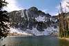
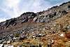
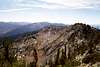
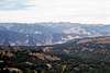
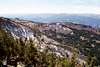
Hard Butte is on the western margin of the Salmon River Mountains and forms part of the divide between the main Salmon River drainage and the canyon of the Little Salmon River in west central Idaho. It rises an abrupt 6,000 feet above the arid canyon of the Little Salmon to the west and from a high plateau of the northwest Payette National Forest on the east. The mountain is formed by an arching south to north running ridge that terminates in a broad buttress with rugged ridges dividing to the northwest and east. Most of the mountain is formed of steep granite with few trees. The north facing slope supports a stunted subalpine forest before dropping off precipitously into Hard Butte Lake. There are also several other lakes in the close vicinity.
The standard Payette National Forest map shows a trail (508) leading to the summit via the northeast ridge. On the ground the signed 508 trail leads to the north base where it becomes a trace and apparently ends (snow may have hid the trail however). A thread of a trail is found on high on the north slope but this is hard to follow on the ground and is not where indicated on the map. A closer investigation is needed to determine if and where a reliable summit trail exists. Most maps show no trail at all. There are the remains of a historic lookout on the summit and it is likely the trail has had little use since it was abandoned.
Most of the drive through the forest leading to the trailhead as well as most of the approach to the mountain burned extensively during the massive 1994 fires that charred nearly half a million acres on the Payette National Forest. Hiking through the dead forest is a not very scenic and the wind hums and shrieks through the skeleton trees. And unfortunately, you may be sharing much of the trail with cows or sheep or ATVs.
Getting There
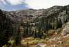
Turn north onto the Brundage Mountain Ski Area road (Forest Service Road 257) off of Highway 55. Coming from the north, this is a left turn 0.4 miles south of mile marker 150 and approximately 6 miles east of New Meadows. From the south this is a right turn 0.6 mile past mile marker 149 or right approximately 4 miles west from McCall. Stay on the main road for about 27 miles to the Clayburn Trailhead. A sign will direct you for the last couple miles. From the trailhead follow the 347 trail for 2 miles to Warm Springs Saddle where the trail splits. Stay to the right for 0.25 mile then take the left turn on the 508 trail to reach the Twin Lakes Basin and the north foot of the mountain. Going left from Warm Springs Saddle will lead to Rainbow Lake to reach the broad east base of the mountain. Some maps show the 508 trail climbing the northeast ridge of the mountain. While the 508 trail does not do this, going cross country to the northeast ridge for an ascent might be a viable route. Regardless of the path chosen it will be about a 3 mile hike from Clayburn Trailhead to the mountain.
Camping
The nearest developed campground is the Hazard Lake Campground on road 257, approximately 21 miles north from Highway 55. Excellent dispersed campgrounds can be found along the east shore of Goose Lake. There will only be a narrow space between the lake and the road, but still the setting is spectacular. The Twin Lakes basin and Rainbow Lake offer nice camping spots right at the mountain’s base. At large camping is permitted virtually everywhere, but there may be cows to contend with.
When To Climb
June until the late fall snows get deep (Oct. or Nov). The road is not maintained beyond the ski resort in the winter, thus getting to this area would require snowmobiles.
Red Tape
None.
Mountain Conditions
Current mountain conditions and access information can be obtained from the New Meadows Ranger District office of the Payette National Forest, (208) 347-0300.
NOAA Forcast