Off-Route Early
Brad's Outdoor Adventures
La Plata Peak (14,336 ft) via Ellingwood Ridge
with Arthur
Class 4
Distance (round-trip): 9.5 miles
Elevation gain: 5,900 feet
La Plata Peak, a beautiful mountain in the Sawatch range, and the fifth highest mountain in Colorado, has a jagged and impressive-looking northern ridge named for the first person to climb it almost a century ago, Robert Ellingwood. Wanting a bit more of a challenging climb than most of the Sawatch fourteeners have to offer, Ellingwood Ridge appealed to me as a viable, even exciting route where I could find some adventure.
Thus, my friend Arthur and I drove to the Lake Creek Trailhead, where we spent Friday night. My watch alarm went off at five o’clock Saturday morning, and we got our gear together to head into the Collegiate Peaks Wilderness. As we would find out, five o’clock still wasn’t quite early enough for what lay ahead of us.
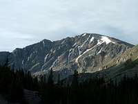
5:30 AM- With all our gear packed and ready to go, Arthur and I walked down the dirt South Fork Lake Creek Road. It was just a short jaunt before we came to the beginning of the La Plata Trail, on the left side of the road. We went up over a short hill in the woods, and from the top I caught my first glimpse of Ellingwood Ridge in the distance.
![]()
View from La Plata Basin Gulch
Just below this we came to a sturdy wooden bridge crossing the South Fork Lake Creek. Here we saw a faint trail going off to the east, and I mistakenly took that to be the Ellingwood Ridge Trail. However, we should have continued on the main trail until crossing the next creek, La Plata Gulch Creek.
We ended up crossing the La Plata Gulch Creek later on, and we bushwhacked our way up the side of the ridge through rough timber for quite a while before I realized my mistake. Once I figured out where we actually were, we corrected the mistake by heading east along the ridge until we came to La Plata Basin Gulch. Here we came to the rushing La Plata Basin Gulch Creek. After finding a passage across that, we had a steep and narrow ridge in front of us, and I knew we were back on track.
We headed straight up the steep ridge until we came to the top, and sure enough there was a climbers trail following the ridge-crest straight up the hill. Our detour behind us, we pressed on along this trail, through more vast forest of spruce and undergrowth.
7:42- Finally reaching timberline, we were greeted with enthralling views of the daunting Ellingwood Ridge and La Plata Peak. We were now in the La Plata Basin Gulch, in a mass of talus for as far as the eye could see.
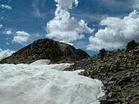
On the Ridge
![]()
Arthur works his way up to Ellingwood Ridge
After stopping for a brief rest and picture-taking session, we started up the steep northern-most slope of Ellingwood Ridge. It was nice talus at first, but the eventual ‘trail’ we came to consisted of loose and ugly scree and dirt. We were able to avoid most of this by keeping to the larger rocks and talus on either side of this path, but in no way did that lessen the steepness.
We continued up, up, up, over several false summits, before finally breaking onto a nice grassy knoll. There was, of course, more steep terrain ahead, but this was a nice break and certainly an opening up of the scenery. We had a good view of La Plata, and the first of the jagged towers of Ellingwood stood directly ahead of us. Looking back over our shoulders, we could see Mounts Elbert and Massive, the two highest mountains in the state, and to our east we could see the huge Twin Lakes Reservoir.
Almost four hours into our hike, as we crested the first of the rocky towers along this ridge, we were finally getting to where Gerry Roach says “The introduction is over.” Indeed, it was.
Following Roach’s advice, we stayed either on the ridge’s top or the eastern side, as most of the western slopes consisted of sheer cliffs. Still, the route-finding through this area wasn’t too difficult, and Arthur and I had some fun with some down-climbing and traversing over and around the many towers.
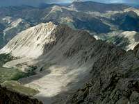
![]()
View along Ellingwood Ridge
It was about two hours later we came to the grassy 13,140-foot grassy summit where Roach says (for the second time), “The view from here is discouraging.” Arthur and I were actually still feeling very good and ready for some more challenge, and the ridge did indeed get a little more challenging here.
Either we took a wrong turn somewhere or we had just come to the crux of the route, for the next half a mile or so consisted of much more difficult route-finding and a lot more down-climbing than up-climbing. We also were faced with some exposure on a good many of the moves, with deep gullies falling hundred of feet below us.
Here we were fully able to grasp the impressiveness of this complex and amazing ridge. Tremendous, impossible-looking towers and walls of rock jutted up all around us, and it was apparent we were in a rugged mountain world now, that few people have seen.
We had both brought our climbing helmets, and I wore mine the entire length of this ridge. More than once I was glad I was wearing it. Once Arthur and I were down-climbing a particularly steep section and he knocked a grapefruit-sized rock down that bounced harmlessly off my helmet. With the often-loose and rotten rock we encountered, I would say it was a necessary asset to my journey, and it did its job well.
The route-finding along this section was a challenge, because the territory beyond the next jutting chunk of landscape was almost always invisible to us. We simply had to find what we figured was the best route for the time-being, follow it to the edge, peer down over the next steep indentation of land, and decide whether or not we would be able to continue any further on that route. More often than not we did pretty well, but a couple times, once we could see what was ahead of us we had to change our game plan and back-track or climb up or down a bit to continue on. It was pretty challenging at times, but it is exactly what I had been hoping for!
One thing I had
not been hoping for, however, was bad weather. We were not in a good place for thunderstorms, and wouldn’t you know, thunderstorms decided to pop up about the time we got through the most difficult of the up-and-down climbing. We could hear some rumbles of thunder, and we saw a few flashes of lightning to the north of us. Even as we began to seek some shelter, a brief shower of hail fell on us. The clouds above us were dark but still somewhat broken up, and it seemed the main storms were to the north and south of us. However, we were below the crest of the ridge at this point, so we couldn’t see west to determine what was coming our way. As we sat there deciding what to do, we watched Mount Elbert enveloped mercilessly by the storm to our north, and hoped that would not be our fate as well.
Eventually though, the storms did pass without hindering our travels. The breeze picked up for a short time but then all was calm again, and we continued on our way.
At last we came to a large, wide gully that required a slippery trek across a nasty slope of scree. We did well in getting across it, but then we had some difficulty in deciding which way would be best to go from there. As had been the norm lately, all we saw ahead of us was a huge rock wall which offered no clue as to what lay beyond.
After some moments of consideration, I decided to follow beside a path of scree all the way to the saddle above this rocky wall and see what I could see. When I crested this spot, I was somewhat relieved to see that we had finally made it to where the ridge turns to the west, and goes uphill toward the summit of La Plata. I was also relieved because there was an obvious route in front of me leading along the top of the ridge, and therefore I would not have to go back downhill to where Arthur was taking a break. Instead, I called him up and we both stopped to enjoy the view and get some energy-food and drink.
As we were sitting at this agreeable spot, I was surprised to see a hiker descending the ridge above us. In a matter of minutes, he was coming down toward us. We exchanged greetings and asked each other about what lay ahead. He had ascending La Plata via the standard route, and was going down the way we were going up. He told us the ridge he had just descended was actually quite easy, with just a bit of rotten rock, and that we could stay pretty close to the ridge-line. This was definitely welcome news to us (the ‘easy’ part, that is), and after the lone hiker passed we continued on our way.
That, I will certainly not fail to mention, was the only person we encountered this entire day, on a Saturday in early August! That fact certainly doesn’t aid in detracting from my appreciation for the non-standard routes of Colorado fourteeners. The amazing area we were able to experience, combined with the solitude it provided, was something you can’t fully understand unless you experience it yourself.
The difficult climbing was over, but in all of Ellingwood Ridge we had not really gained much elevation. The altitude gain we needed to reach the summit of La Plata conveniently lay right in front of us, and up we went!
We followed along the top of the ridge for a good while, pausing to peer down the breath-taking couloirs dropping into La Plata Basin Gulch as we passed. Also, the higher we went, the better views we had of the ridge we had just ascended, and the more massive La Plata became in front of us.
We descended a little onto the southeast side of the ridge to bypass a large, cliffy buttress. After getting around that, we found ourselves on a gigantic ridge of steep talus, leading up to the summit of East La Plata, Point 14,180. This ridge was very reminiscent of the long and steep slope we had first ascended to get onto Ellingwood Ridge, only (thankfully) without the scree.
I was getting very tired at this point, and found myself slowing down considerably. As we neared the false summit, Arthur and I stopped for a good long break. I downed an energy drink and some more food, and we rested a while before continuing on. We still had our eyes on the weather, which was sunny at the moment but still unsettled.
That break was all I needed, and I felt great the rest of the way. It was just a short hike up some more talus to get to the top of Point 14,180, where we had a great view of La Plata Peak, right in front of us.
However, the path to La Plata from here was not so direct as our view. We had to descend onto the south side of the ridge and go around several more towers similar to those we had encountered all along Ellingwood Ridge. These final towers did not actually take too long to get around, and after another short but steep uphill, we were on the gentle saddle leading past a small snow-field to the summit.
To the Finish!
3:24 PM- It had taken
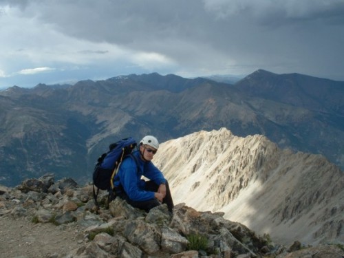
ten hours to get to the summit. We had clearly underestimated the time we would need to traverse Ellingwood Ridge. Much of that time had been spent route-finding our way through its many interesting puzzles. But were we ever excited to reach the top, and we had it all to ourselves! Signing in at the register, however, I was not surprised to find out we were the 17th and 18th people of the day to sign in.
We were now 14,336 feet above sea level, on top of La Plata Peak, the fifth highest peak in the state of Colorado, and–at last–the hardest part was behind us. The views all around us, including that of Ellingwood Ridge, were fantastic, and I took the opportunity to take numerous pictures. The weather, also, was beautiful when we arrived, with no wind and mostly sunny skies.
As had already happened a couple times throughout the day, however, the weather was about to change dramatically once again. Even as we stood there, the skies darkened, the wind picked up, and it was apparent to us that more thunderstorms were in the making.
Thus, after spending only 20 minutes on ‘our’ hard-earned summit, we decided it was in our best interest to start downward.
We descended via the standard Northwest Ridge Route. Most of this class 2 trail consisted of slippery pebbles or dirt which became quite annoying after a while, especially with my boots which didn’t afford much traction. We were able to make part of the descent considerably easier, however, with the aid of a large snow field covering some of the ridge’s steepest area. This definitely quickened our altitude loss for a while.
Eventually the trail begins to switchback downward into La Plata Gulch. This was a beautiful area, but the trail was still rather slippery for my worn soles. The storms had once again passed without incident, and the sun was actually quite hot as we continued downward into the mass of green. Marmots were everywhere, and quite unshy in this area I might add.
3:43- We finally reached timberline again, sort of. We continued in and out of trees as we continued along the bottom of the gulch next to La Plata Gulch Creek. The trail was solid and flat for a while, but once again it turned into a slippery path of pebbles on hard dirt.
![]()
Gotta Envy the Life of a Marmot
That is pretty much what the trail consisted of until we finally made it to where the trail crossed over the creek on an unimpressive, yet effective little wooden bridge. (This was the spot where we should have turned off this morning to go to Ellingwood).
Here the trail became flat and nice again, and it remained that way the rest of our journey out of the woods. It was very calm and quiet in these woods; quite a contrast to the stormy adventures we had just experienced on the jagged crags a few hours earlier.
After stopping to sign in at a Collegiate Peaks Wilderness register, we followed the trail the short distance to the South Fork Lake Creek bridge, where we had left the trail many hours ago.
6:18 PM- We made it back to my jeep. It had taken almost 13 hours to traverse the spectacular Ellingwood Ridge to La Plata Peak and return to the trailhead. Amazingly, Arthur and I were still feeling pretty good, but ready for a real meal!
Conclusion: For amazing, rugged scenery, route-finding experience, rock climbing, some exposure, physical workout, solitude, and fun, Ellingwood Ridge was worth it! One thing to note is you need to be prepared for the weather, as well as the physical strain. I have always taken more than enough water to the mountains with me, and this time we used it all up. Also, as I mentioned earlier, the climbing helmet came in quite handy.
The route-finding along Ellingwood Ridge can be challenging at times, but Arthur and I learned it is just best to keep going with what looks best at the moment, and adjust if necessary as you go. Most of what we did was class 3 climbing, though we did traverse a few sections of class 4 area. This can probably be avoided if you take greater pains to do so, but that would require much more up and downhill. We had plenty of that as it was.
Ellingwood Ridge to La Plata Peak?
Sensational!
Comments
No comments posted yet.