Epic, fail: the southern California 14er link-up

Epic, fail: the southern California 14er link-up

Page Type Page Type: Trip Report
Date Date Climbed/Hiked: Oct 7, 2009
Activities Activities: Hiking, Scrambling
Seasons Season: Fall

Just the facts, ma'am

This is a failed attempt to link the California 14ers from Langley to Tyndall as a dayhike. I gave up after Russell, but had to "bail" back to Shepherd Pass to meet my ride, making for a long day -- 19h40.

Route: I took a "shortcut" to Langley, then dropped into Rock Creek, climbed to Crabtree Pass, and traversed to Trail Crest to pick up the main Whitney trail. I bagged Muir and Whitney from the trail, then dropped down Whitney's north slope and up Russell's SW chute (left branch). From there, I descended the north ridge, then followed Wallace Creek to the JMT to Shepherd Pass.

Conclusions: Old Army Pass is probably the best way to do Langley at night. With moonlight, the descent to Rock Creek would not be bad in the dark, even without having done it before. The traverse from Crabtree Pass to Trail Crest is slow, but probably faster/easier than the alternatives. Wallace Creek and the JMT are very fast going if you jog, but probably too far out of the way. Adding either Tyndall or Williamson in a day seems doable, but adding both would be extremely tough.

Epic, fail

The efficient peak-bagger typically climbs the Sierra 14ers in six outings (listed from north to south): Thunderbolt through Sill, Middle Palisade, Split, Williamson and Tyndall (usually separately or as an overnight), Russell through Muir, and Langley. However, the peaks naturally divide into two groups, Thunderbolt through Split and Tyndall through Langley, and speed climbers have climbed each group as a single, mostrous outing. Since the trailheads for Split and Tyndall (Red Lake and Shepherd Pass, respectively) are much lower than those for Thunderbolt and Langley (South Lake and Horseshoe Meadows), the groups are climbed north-to-south and south-to-north.

I was feeling a bit cocky after my last (successful) epic, and had managed to repress memories of the worst parts, so I thought it was time to try something similar in the Sierra. Thunderbolt to Split would be treacherous this time of year, but Langley to Tyndall fit the bill. My plan was to summit Langley near first light and Tyndall at dusk, making the most of the short day to navigate unfamiliar and/or difficult parts of the route. If I could summit Langley around 6:00 and Tyndall around 7:00 or 7:30, the whole thing would be roughly 20 hours.

I was fortunate enough to arrange a pick-up at the Shepherd Pass trailhead Wednesday night, so on Tuesday I drove up to Horseshoe Meadow, packed, and settled in under a sleeping bag and blanket for a few hours' cold sleep in the nearly-empty parking lot. My attempt was almost prematurely doomed when my cell phone alarm did not go off at 1:45, but fortunately my watch gave a few pathetic chirps at 2:00 before its battery died. I forced down an early breakfast, and was on the familiar trail by 2:15.

Doug had sketched out a shortcut to the right of Old Army Pass (my original route), which would cut out part of the normal sand slog. Taking my bearings from the Cirque-Langley ridge's moonlit silhouette, I headed to Muir lake, then aimed for the next valley to the right of Old Army Pass. While I eventually found a few semi-random ducks and bits of a faint use trail, I probably strayed too far to the left. I endured some nighttime boulder-hopping and bushwhacking, and had a brief scare when I nearly soaked my foot in a partially-frozen bog, but eventually reached the lake at the base of the valley.

The bottom was mostly smooth and stable, and I was pleased with my progress despite earlier setbacks. As the lefthand side steepened and the valley appeared to cliff out, I climbed the looser slope to the left ridge, where things got "interesting." Instead of the expected sand-and-rocks of Langley's south slope, I found a complicated and surprisingly long class 3-4 ridge -- exactly what I was hoping to avoid in the dark. The best approach seemed to be to stay on the ridge or just to its right. At one point I wasted 15 minutes trying to drop down around the right side of a steep-looking gendarme, which I eventually had to climb, descending some unlikely class 4-ish cracks on its left side.

Cold on LangleyCold on Langley
For once I picked a good use trail up the sand, and after getting off the ridge at 5:45, was on top around 6:30. This was 30 minutes later than I had hoped, and 15 minutes slower than my predicted pace, but not too bad. I took the necessary pictures (SPS box, myself) and a few more of the foggy dawn, signed the register, and quickly headed north, brushing the hoarfrost off my gloves and hat.

Sheep on LangleySheep on Langley
Running down the sand toward the Major General, I was surprised to hear someone else apparently doing the same. Turning around, I instead saw a large herd of bighorn sheep trampling a wide trail in the sand as they ran to get out of my way. They stopped when I did, and I took a few grainy pictures before continuing downhill, crossing numerous sheep tracks. From the saddle, I dropped down a gully to the right on class 2 scree and slabs, and reached Rock Creek around 7:20. I headed straight for the slabs to the left of the Miter, passed Sky Blue Lake on a trail to its east, then headed up the ravine to Crabtree Pass, arriving at the saddle around 8:40. Nearly six and a half hours from the trailhead, it was finally warm and bright enough for me to switch to my daytime garb.

Crabtree passUpper Crabtree Lake and sandhill
Marsh traverseTraverse below Marsh
As I shed layers and had a snack, I studied the route ahead. From what I had heard, most people climbing Whitney from this direction (amazingly, some do!) drop down the other side of Crabtree Pass, then climb the "dreaded sand hill" to Discovery Pinnacle. A more appealing alternative would be to contour around below McAdie and Marsh, then follow the ridge to Trail Crest. I saw what looked like a continuous broken shelf north of the gash in the ridge before Marsh and, by angling across some slabs, managed to avoid most of the dreadfully loose sand and scree. A class 3 scramble north of the gash got me to the shelf, and after dipping into a couple of chutes along the way, I climbed to the ridge near a low point south of Whitney Pass.

The ridge from here to Trail Crest was slower than I expected; the top was blocky, and the rocks on the east side were covered with hoarfrost. I eventually made my way carefully to the main trail, and passed a few hikers struggling up the last switchback. I cruised along the trail and scrambled up the short slope to Muir, arriving at 10:45.
Langley and switchbacksLooking back from Muir
Given others' times, I knew at this point that I had a very long day ahead of me, but thought that I might at least be able to do either Tyndall or Williamson.

Only slightly discouraged, I dropped back to the trail and trudged on toward Whitney. I had never climbed Whitney by the trail, and just as when I passed the hikers near the top of the switchbacks, I was struck by how long the climb feels this way. The summit is visible for hours as you struggle up the slope to trail crest, then along the endless ridge, finally turning left and coming at the hut from the west. I finally arrived at the hut around 11:30 feeling slow and tired, and had some pop tarts, hoping they would revive me. Unless I recovered, it seemed unlikely I could complete the traverse, so I tried to take advantage of the cell phone reception to arrange an early pick-up at the portal. Unfortunately I could not connect, so after resting a bit and studying the Wallace Creek drainage and Barnard's south side, I headed for Whitney's north slope.

North from WhitneyThe day to come
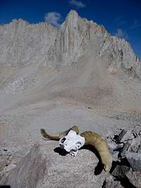
I was still feeling a bit slow, and what I saw of the top of the Mountaineer's route was not encouraging: the hoarfrost I had encountered earlier was (not surprisingly) thicker on Whitney's north side, making the slabs treacherous and nearly useless. I headed farther west to a section that had received some sun and headed down, moving carefully on the slabs and trying to stick to the unpleasant but predictable scree where I could. Far too much later, while walking carefully across the scree near Whitney-Russell Col, I had my second bighorn sighting of the day, this time in skeletal form.
Russell and SkullBighorn below Russell
Still feeling slow as I made my way up the climber's trail in Russell's southwest chute, I decided to cheer myself up by trying out the class 4 left fork rather than slogging up the rest of the right. After negotiating an awkward crack at the bottom and running into tough climbing to the right farther up, I zigzagged left then right, and came up between Russell's two summits around 2:20.

Russell summitTopping out on Russell
I had heard people on the summit as I climbed, and seeing that they were still there, I hurried along the ridge to meet them. They turned out to be Kurt and two clients, summiting via the east ridge from Upper Boyscout; I'm not sure what they thought of my route choice. We stood and talked for awhile, and I again failed to contact my ride. Then they headed off down the southwest chute, while I began the approximately 24 mile return trip down Wallace Creek, along the JMT, and over Shepherd Pass.

Rest, conversation, and some jerky-based trail food mix donated by one of Kurt's clients gave me new strength. I scrambled quickly down the unfrosted north ridge, then made my across the talus to Wallace Creek for fresh water.
Wallace Creek trailWallace Creek drainage
The trip down to the JMT is long but fast, especially after dropping down off the hump between Wallace and Wales lakes and picking up the use trail on the north side. Walking and jogging along while admiring the scenery, I even briefly contemplated climbing Tyndall. However, reaching the JMT junction at 5:00 with 19 miles to go, I decided that heading straight home might be best.

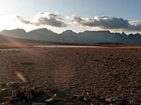
Wallace Creek trailSunset on Great Western Divide
Whitney from the northwestUnusual view of Whitney
I was treated to an unusual view of Whitney as the sun set behind the Great Western Divide, and I made relatively good time to the turnoff to Shepherd Pass. I kept up the pace on the gentle but unrelenting climb to the pass itself, but seeing the same view of Tyndall's northwest slope and the nameless peak by the pass, I began to feel my fatigue. I put my headlamp back on at some point, plodded on, and reached Shepherd Pass around 7:30.

While struggling with my camera near the sign, I was surprised by my phone, which I had forgotten to turn off, telling me I had voice mail. I quickly called my ride, who miraculously had reception at the trailhead, and told her (optimistically) that I should be down around 10:00. Having set the bar for myself, I donned my headphones and set off down the pass at a shuffling 5-6 MPH jog. The upper section was in surprisingly good shape, and other than the rocky section in the pothole, I was able to jog most of the trail down to the evil sand hill. The moon rose spitefully as I climbed, silhouetting first the false saddle, then the real one.

I resumed my jog at the saddle, determined to be back by 10:00. With my mind entirely focused on relaxing, maintaining the pace, and not tripping, I actually enjoyed the late-night jog. At least, my total focus kept me from thinking about how long it was taking to reach the creek, and kept me awake. When I tried walking some stretches, my mind began to wander. Maybe it was just the late season, or maybe someone had done some work, but the creek crossings were easier than I expected. I jogged into the parking lot at a respectable speed at 9:52 PM, too pleased at my time down the pass to be tired. I had failed, but it was still a good epic. I eagerly consumed the sandwich and beer -- not trail mix! -- then immediately passed out in the car.

Could I have done the whole link-up? Given warmer weather and more sunlight (and maybe better nutrition), I feel confident that I could add Tyndall in at most 2 more hours. However, I would need to take some cross-country shortcuts and significantly improve my pace on existing sections to add Williamson in under 24 hours.


Comments

Post a Comment
Viewing: 1-20 of 35
12
cp0915

cp0915 - Oct 9, 2009 11:36 am - Voted 10/10

Awesome Effort!

Stoked just reading it! Thanks man.

seano

seano - Oct 9, 2009 4:19 pm - Hasn't voted

Thanks!

It was surprisingly fun, and I got to see a lot of new areas despite having climbed the peaks before. Still not quite ready for the full thing, though.

McCannster

McCannster - Oct 11, 2009 2:20 pm - Voted 10/10

Great job Sean

I think I need to start planning a large epic...mine are few and far between.

seano

seano - Oct 12, 2009 9:43 am - Hasn't voted

Thanks!

And I need to learn to lead trad, or at least climb at some respectable grade. Maybe I'll hit the plastic this winter.

Princess Buttercup

Princess Buttercup - Oct 15, 2009 8:21 am - Hasn't voted

Wow.

Great read. Makes me think almost anything is possible. But I think I may just try the first half, well, first...

Mmm... sandwich and beer, huh? Sounds like a good driver.

seano

seano - Oct 15, 2009 9:47 am - Hasn't voted

Re: Wow.

Yeah, the first half is totally doable -- it's a lot of cross-country travel, but not too much distance once you get to Langley. And yes, the driver made this much more pleasant.

Sierra Ledge Rat

Sierra Ledge Rat - Oct 18, 2009 9:21 pm - Hasn't voted

....as a dayhike...

Ha! A day hike! To be young, strong and ambitious again....

seano

seano - Oct 19, 2009 11:51 am - Hasn't voted

I blame Bob Burd

Or just too lazy to carry overnight gear. Besides, it's only 10 miles or so in a straight line... ;-)

lavaka

lavaka - Oct 19, 2009 11:30 am - Hasn't voted

other TRs

Sounds like it was not only a remarkable feat, but that you had a lot of fun doing it.

You mention once or twice that other trail runners had done this route. Could you post some links to their trip reports? I'm curious how people are doing this linkup.

seano

seano - Oct 19, 2009 11:43 am - Hasn't voted

Re: other TRs

There's Hans Florine's page; he bivied after Langley and skipped Williamson on the southern leg, but did the same basic thing I was trying. He doesn't give route details, which is part of why I wrote this up. I think a couple of other people attempting the 14er record have either done or tried this (maybe Jack McBroom on a later attempt?), but I don't know of a detailed trip report.

And yes, it was a blast in some perverse way.

suddendescent

suddendescent - Oct 19, 2009 2:04 pm - Voted 9/10

The thrill of a challenging moment...

Thank god you folks are around to give us great story telling which causes folks like myself to search for breathtaking but overlooked mountainous scenery to describe for the masses !

I in being a novice which is fearful of heights as opposed to being a seasoned mountain climber tends to look at such adventures with a certain measure of fear and envy considering the unrealised challenges to tackle starting with those closer to home.

To give an example, while satellite imagery of the northern fringe of the Groulx hills in Quebec (in immediate vicinity of the Manicouagan reservoir-check out the picture in the 2006 issue of Encarta to get an idea of the meteoritic crater and the topographical starkness of the northern perimeter of the hills...) gives a certain idea of the topography to uncover (check my WEB site attainable from my profile for additional satellite imagery), it was a surprise to realise that few ground level images exist to give credance to what is suspected as being stark topography which must offer some amazing challenges if you include what is south west of the crater with mountainous scenery which first starts with an impassible wall once the road ends...

Considering all the challenging moments described by people adept at taking risks sharing with us amazing images and accessory descriptions of the stark topography to uncover elsewhere, I realistically expect to have some contributing members describe at one point in the future the thrilling moments trying to conquer a lesser known place relatively far beyond the reach of civilisation. In the meanwhile I do definitely enjoy reading the accounts of those which went elsewhere on this earth to give a description of their own challenges and the rewarding moments which followed !

No need to have a biased attitude to understand that this region of the world does deserve a certain measure of attention in order to get a more objective image of it's characteristics .

albanberg

albanberg - Oct 19, 2009 3:21 pm - Voted 10/10

cool man...

epic trip indeed!

seano

seano - Oct 20, 2009 1:50 am - Hasn't voted

Thanks!

It was a good challenge, but still mostly fun.

MoapaPk

MoapaPk - Oct 19, 2009 9:52 pm - Voted 10/10

No frosting

I bet your pop tarts were not frosted -- that was the problem.

seano

seano - Oct 20, 2009 1:49 am - Hasn't voted

Good call

Next time, it's s'mores flavor all the way. Seriously, I had packed a bunch of trail mix, which has something like 50% of calories from fat, while something like 20% or less seems to be ideal. Maybe that was a problem, or maybe I just felt off for a couple hours.

Bob Burd

Bob Burd - Oct 20, 2009 11:38 am - Voted 10/10

Nice job

Good show, Sean! Always enjoy your adventures. I would suggest two changes for next time:

1) From Crabtree Pass, drop down a few hundred feet on a slight arcing path to Discovery Pinnacle. The slope looks like horrible sand and talus, but it isn't too bad. Much better than the ridge along Mt. Marsh.

2) Bring cold pizza for energy. Tastes good when most other stuff is unappetizing late in the day. Matthew sold me on that one. :-)

seano

seano - Oct 20, 2009 2:20 pm - Hasn't voted

Thanks!

I was a big fan of cold pizza even before Matthew reminded me of things besides fish (I failed to turn him on to sardines). But I'd want to balance it with something easier to digest to keep a consistent energy level.

The traverse to Discovery sounds like a good idea, though the little scree I had to cross higher up was very loose. However, the real time savings will probably have to come from heading straight toward Williamson from Russell (near Barnard/Trojan/Versteeg), tough going late in the day.

Buckaroo

Buckaroo - Oct 20, 2009 3:51 pm - Voted 10/10

Re: Thanks!

Nice TR.

The best thing for an all out effort, especially high aerobics would be some energy gels. Don't even eat anything for breakfast.

seano

seano - Oct 21, 2009 7:56 pm - Hasn't voted

Re: Thanks!

I've found that pop-tarts, supplemented with a few energy bars, work reasonably well while hiking quickly or jogging. I have used gels while running, because I can't digest anything else, but they're about 10x as expensive per calorie as pop-tarts, so I usually don't bother.

forjan

forjan - Oct 21, 2009 9:32 pm - Hasn't voted

Re: Nice job

I always bring pizza + gummy bears.

Viewing: 1-20 of 35
12


Parents 

Parents

Parents refers to a larger category under which an object falls. For example, theAconcagua mountain page has the 'Aconcagua Group' and the 'Seven Summits' asparents and is a parent itself to many routes, photos, and Trip Reports.

California 14ersTrip Reports