
|
|
Route |
|---|---|
|
|
42.61377°N / 0.47831°E |
|
|
Hiking |
|
|
Summer, Fall |
|
|
Most of a day |
|
|
Grade I UIAA |
|
|
I |
|
|
Overview
Starting at the end of the Espigantosa dirt road, by the waterfall of the same name, this can be considered to be the "normal" route to the Pico de la Forqueta. For the first three hours or so, it's the same route used to climb Posets and climbers can enjoy the moral (and material!) support of the Angel Orús hut. After leaving the trail to Posets, your way to the Collado de Eriste and the summit will turn much lonelier and quieter. It will take you along the shore of the Ibón (lake) de Llardaneta, the short and steep ramp under the Collado de Eriste and an easy rocky spur between the col and the summit.Getting There
Road access:-From Zaragoza to Huesca there are 72 km, all of them on an excellent recent highway. Leave Huesca towards Barbastro, following road N240. At Barbastro take N123 and N123a to Graus. Cross Graus all along the main street and keep on road A139 towards Benasque/Cerler. After 56 km you will be at the small village of Eriste. Immediately after the village, there's an electric plant to your left. Watch out for the sign to "Refugio Angel Orús" in the first turn left after the plant. That's the beginning of a narrow road that winds uphill. At first it's got asphalt, but in no time it changes into concrete and shortly afterwards turns into a dirt road. Take left (downhill) on the first crossroads and right on the second one, always following the (not too visible!) wooden signposts that indicate "Refugio".
The dirt road ends at a small parking area, usually crowded by the vehicles of those sleeping at the Angel Orús Hut or attempting to climb Posets in a long day. If you get there too late, you might have trouble finding a spot to leave your car.
-From Barcelona: Follow highway A2 towards Lleida. From Lleida you will need to take road N230 northwards, towards Alfarrás and Benabarre. When you reach Benabarre turn westwards on road N123, following the signs to Torres del Obispo and Graus. That's where you join the route previously described from Zaragoza.
Train access:
-Train Barcelona-Zaragoza. You can decide to leave the train at Zaragoza and take a bus to Huesca and a further bus to Benasque (see Alosa for the timetable, on external links section), or leave the train at Lleida. Further transport will be required to go on.
-After Zaragoza, there's also the option to follow to Huesca by train or by bus(see Alosa). From Huesca to Benasque trains are no option, you will need to take the bus (see Alosa or Tel. bus station of Huesca: 974-210700).
Major airports: Zaragoza (211km), Barcelona (317 km)
Route Description
 |
 |
 |
 |
 |
 |
 |
 |
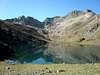
The trail continues on the upper side (grossly northwest) of the hut. It's properly indicated by a wooden signpost that marks the different options of trail GR11.2, as well as by red-and-white paint marks. You will need to follow the obvious uphill path and (whenever the wooden signposts come in sight) choose the direction towards the Collado de Eriste. That way, you will cross a slightly confusing area where the path tends to disappear between large rocks and finally come to a more grassy stretch close to the entrance of Canal Fonda (normal route to Posets). At about 2500 meters (above sea level), a stone by the right side of the path is marked in red paint with the legend "Posets" and an arrow. Thats where you have to turn left and face a grassy slope with a less-trodden path. Keeping to your right, climb that grassy slope until you come in sight of the Ibón de Llardaneta and the Pico de la Forqueta. The final approach to the Collado de Eriste leaves the Ibón (lake) to your left and climbs across a scree slope to your right, always marked by the red-and-white paint of the GR11.2 trail.
When you reach the Collado de Eriste there will be only 140 meters left to climb. Start walking south on the scree slope, by the obvious path. It disappears rather soon after turning right and contours some low cliffs by the Millars (west) side of the col. A final cliff can be climbed by means of an easy (I+ UIAA) chimney, and you will find yourself halfway to the summit. Just walk along the thin ridge (aerial, minimal descent) to the final slopes of the peak, on the Llardaneta side (east) of the Col. Those final meters have a rather good path, with loose scree, disappearing from time to time in areas with bigger stone blocks. The path will lead you to the characteristic notch in the rock (that's the "Forqueta" lending its name to the mountain) and when you reach it the climb ends by turning to your right and scrambling for a couple of minutes to reach the main summit.
Essential Gear
Assuming you can climb a II grade (UIAA) there are no special needs in summer time, though walking poles are always useful. Whenever you can find snow in the upper parts of the mountain, be careful to carry complete winter equipment (ice axe, crampons, even harness and rope could fit in...) and take all safety measures. This is a high mountain, and you should treat it as such. Never mind if it's easy or not.External Links
Alosa: Web page of the bus company in charge of many connections between the province capital of Huesca and the Pyrenees villages (including the Huesca-Benasque line).RENFE, spanish railways: Intended to make it easier for those who choose the train when traveling to Benasque.