Preface
Yes, I have a goal regarding state highpoints. It is not, however, to climb every one of them. It is to greet the apex of the twenty-five highest. So why would I be worrying about frittering away time bagging the 26th highest, Mt. Mansfield, in the Green Mountains of Vermont?
The question is valid and deserves an equally straightforward answer: because it is there. Now that the curmudgeonly sarcastic remarks box has been dutifully checked, I will simply say that the challenge of a winter ascent of any of the New England state highpoints is so full of magnetism for me that to resist the opportunity was unthinkable. There is a lure emanating from Mt. Mansfield, its unruly undulating profile covered in a winter cloak of white, which pulls, tempts and dares.
Attempt #1
I first attempted Mansfield in March of 2010. My standby flying agenda flew me into JFK from Salt Lake City on the red eye, then puddle-jumped me to Burlington. In a Thrifty rental car I drove to the Smugglers Notch winter parking area near Stowe Mountain Resort about noon. The day was not particularly cold – that is, not bone-chilling cold – but the winds at the summit were hurling the scattered clouds north to south as though they were bolls of freshly picked cotton in a wind tunnel.
The ominous winds did not worry me nearly as much as a nagging knee injury I had sustained less than two weeks earlier. Having taken a shot at curing the ailing joint, I knew that whatever the ailment was, it had not completely healed. But I had only the few days of that week to make the attempt because it was Spring Break at the private college where I was instructing a class in aviation science.
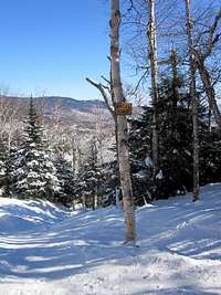
I launched out shortly after noon, my pack loaded with appropriate clothing for a possible hurricane on top and my MSR Lightning Ascent snowshoes tightly strapped to my climbing boots. I found the trailhead signboard upon which there was nothing written or posted, but I knew from having read descriptions of the route on SP that I was in the correct place. After a few yards I spotted the weathered trail register, and after a few more steps I began to see the comforting white blazes which marked the “Long Trail South.”
Mollycoddling my painful knee I persevered for approximately 600 vertical feet before admitting to myself that it was honestly not going to happen today. Disappointed I reversed direction and made my way carefully down the winding snowy depression that was the trail and felt pain with every step. You win some and you lose some; today was not going to allow itself to be placed in the win column. That would come another time.
![Mt. Mansfield]() My 2010 turn-around point. I immediately began making plans for a return trip to complete "unfinished business."
My 2010 turn-around point. I immediately began making plans for a return trip to complete "unfinished business."Attempt #2 - Preliminary information
![Mt. Mansfield]() March 4th, 2011. Ready again with 5 degree temperature and two good knees. :)
March 4th, 2011. Ready again with 5 degree temperature and two good knees. :)![Mt. Mansfield]() March 3rd, 2010. Ready in spite of a bum knee. :(
March 3rd, 2010. Ready in spite of a bum knee. :( Fast forward exactly one year to 2011. Picture the same scenario for the same reasons but with the following important changes: no red eye flight but rather a connecting flight through Detroit and a good night’s rest before driving to the TH from Burlington; a forecast heralding crystal clear skies coupled with tolerable winds; and most importantly, a healthy body, geared up and ready for the second try. I was praying that the weather forecasters had paid attention in meteorology classes because we arrived with overcast heavens and the north winds were slicing and piercing utterly without mercy.
Oh, there was one other small change from the prior year: a cold front had pushed through two days earlier and plunged temperatures into the New England basement. The forecast low for climbing day was 5° and the high a whopping 14°. That was for Burlington proper, so temps at the ski resort and on the top of my prospective highpoint were undoubtedly going to fall well short of urban numbers. But I would gladly trade snow squalls, low visibility or driving sleet in favor of below-average temps.
Have you ever made meticulous plans to do something, arrived at your destination and then suddenly discovered that despite your care in planning you somehow managed to leave an important item behind? And do you remember the sinking feeling which accompanied the revelation that the item was not with you but rather lurking in some cranny back at your home? And the anger at your inane stupidity for accomplishing the unthinkable? I did, and it burst on me like the premature detonation of a short-fused firecracker as I unpacked at the motel in Burlington: no snowshoes! Good grief, Charlie Brown! How could it be? But it was.
Fortunately for me there was a brochure in our room which offered information about the hamlet of Stowe and its attendant attractions. I contacted the Topnotch Resort where a kind lady referred me to the Nordic Barn, and a quick phone call gave me the assurance that I would be able to rent a pair of snowshoes the following morning as I drove toward the trailhead. Whew, disaster would be avoided, and with only another twenty bucks being chucked into the “expense” column of my trip log.
Burlington to the Long Trail South TH - Ascent Day
I awoke, peered through a frosted window pane and saw that the heavens were indeed blue, as promised by the local weatherman the prior evening. And it looked like the forecast for cold temperatures was also right on the mark (gosh, couldn’t they be just a little bit wrong on this issue?). I dressed, hugged my wife goodbye and loaded my gear into the red Aveo with which Enterprise Rent-A-Car had entrusted me. Had I not had to spend ten minutes scraping ice from the windows I could have been on the road immediately, but the day was smiling at me and I was grinning back, eager to make the 36-mile drive to the TH and get this effort underway.
Our motel was on Williston Road near the Burlington International Airport. From there it took a mere 30 minutes to reach Exit 10 on I-89. As I cruised on the interstate in light traffic I could easily see Mt. Mansfield’s facial profile: the forehead gracing the southern end, the prominent chin jutting upward at the northern end. The better view of the profile is from the east, but one can pinpoint the features from the west as well. There was an elongated thin cirrus cloud crowding the chin, the gray smudge of a beard which soon evaporated into the azure morning sky.
The Nordic Barn Bike Rental and Ski Shop, a distinctive plum-red structure standing just past the turn off to the Topnotch Resort, had opened for business at 8 o’clock, but I appeared to be the first customer of the chilly day. A friendly gentleman with a bushy gray moustache assisted me with the fitting of the Atlas snowshoes, a model far larger than my own MSRs but with a binding system that was first rate. As I adjusted the bindings in the warmth of the shop a young man with a shock of blond hair appeared out of nowhere and asked me where I was headed.
When I told him I was hoping to be on top of the mountain he wryly commented that he had been there often and that today looked like a stellar day for reaching the top. He was not a snowshoer but a skier, and he stooped down to sketch me a small map on a 3x5 card. “Here is the trail, this is where it comes up to the crest, make a turn north and you’re right there.” He went on to show me where I might find the picturesque Lake of the Clouds, just north and down from the Adam’s apple. Wishing me good luck he slipped out the door, skis in hand.
I was soon on VT-108, more excited than ever about the prospect of my adventure now that I had those snowshoes tucked safely away in the trunk. There was much more snow heaped along the shoulders of the road than there had been last year. I must note that there is no shortage of sleeping accommodations in Stowe, and each offered quaint architecture combined with names suggesting the ambiance to be expected: Innsbruck Inn, Bear’s Lair, Edelweiss Convenience Store, Fireside Tavern, Hob Knob Inn, Sun and Ski Inn & Suites, The Gables Inn, The Arbor Inn Bed & Breakfast.
![Mt. Mansfield]() A touch of Austria in Stowe, VT.
A touch of Austria in Stowe, VT.
As I passed under the gondola cable stretching from the Stowe Mountain Resort to the base of the mountain gondola lift, the suspended red tram cars glistened in the bright morning sunshine. I eased into a parking spot facing east, the lot resembling an oval bowl with the bulldozed snow at its edges reaching a height of eight feet or more. Mine was the third vehicle there; next to one SUV three young men were hurriedly putting their climbing gear together, obviously eager to get moving and generate some body heat.
As I attempted to efficiently and quickly strap on my gaiters and don my snowshoes I queried as to where they might be headed. “We’re going to do some ice climbing up near the notch,” was their reply. Well, that would indeed be a cold proposition, I thought. My GPS put the elevation at 1,550’ here, and I tucked it carefully into the small cloth cubby hole in my waist band. I secured my digital voice recorder in the left pocket of my snow pants and my camera into the right, hoping that the numbing cold would not render them useless.
Losing the trail, gondola summit & bootpack
One of the ice climbers offered to take my picture and I returned the favor. They departed and quickly disappeared up the snowy Smugglers Notch road. I wasn’t far behind them, leaving my car at the stroke of 9:27 a.m. I was happy for the hand warmers I had slipped into my black mittens; the warmth was a reassuring comfort on the backs of my hands. Today there were no clouds overhead to give me a hint as to the wind status at the top of the mountain, so I continued to hope that the forecasters’ predictions for light winds would pan out. Down here in the trees there was no detectable breeze. I remembered this path from my last year’s experience; four minutes after leaving the parking lot I turned left at the trailhead sign, a brown small-scale billboard upon which two pieces of paper, 8 ½ x 11, had been affixed on the north side.
![Mt. Mansfield]() The modestly adorned TH sign on Smugglers Notch road.
The modestly adorned TH sign on Smugglers Notch road. The one offered helpful information: “Long Trail South” and a black arrow pointing west, splitting the logo of the Green Mountain Club into two hemispheres. The second offered “Leave No Trace” information, the details of which I would read another time when the temperatures had nudged upward, say, 30 or 40 degrees.
At first the trail was impossible to lose, a deep winding luge run tracked with a jumbled mixture of imprints from skis, snowshoes and hiking boots. Faded white blazes on the tree trunks were like lane markings on a highway, and I soon had to stop and de-layer in spite of the biting cold air. I was making good time and felt exhilarated with each step: this was going to be a good day.
After 30 minutes I stopped to take an elevation reading: 2,450’. Wonderful – less than 2,000’ to the summit! Hearing something above me I looked up to spy a snowshoer coming down the trail. As he approached I asked him if he had been to the top. His response was not what I had been hoping for: “No, I lost the trail a little ways up, spent 30 minutes trying to find it, and decided to call it a day. You will see where I lost it because my tracks more or less go in circles.”
Hmmm, that was not good news. I was already higher today than I had been last year, but so far the trail was evident and seemingly difficult if not impossible to miss. What might change in the next few hundred yards? I would have to discover this for myself. Yes, the ski tracks were increasingly making a mockery of the distinct trail I had been following, but what about the obvious depression and the blazes?
My descending friend was, however, correct. Maybe seven minutes after our encounter his tracks led in three different directions and soon carved 180° turns and came back to the intersection from which he had begun. I checked out each of his probing tracks with results mirroring his. As for the blazes, forget about it. They were gone, history, nowhere to be found. Ski tracks were everywhere and in all directions. Every fissure – and there were plenty of them – looked like a possible trail. This was like trying to put together a puzzle for which you have small intricate pieces and for which you have no picture to give you clues about colors or images or relationships.
But in another sense I did have some clues. I knew where I was in relation to the summit and I knew that the skiers had come from the Stowe Ski Resort area, probably from a run on the north edge of the resort. I wasted no more time plodding around without a goal, finding the most heavily used ski trail and following it to the south. Soon I met skiers coming in the opposite direction, and I queried the first pair about where I might be. They both smiled and said that I was only a few minutes from the Chin Clip run – I couldn’t miss it.
I thought to myself, “Now we’re getting somewhere,” and I stayed with the ski tracks leading to the open slope of the Chin Clip ski run. Well, this wasn’t the Long Trail, but it would have to do. The hardened snow, the skiers with masked faces and helmeted heads, the whoops and hollers of small groups, the continued brilliant sunshine, the knowledge that I was making distinct progress – all of them contributed to a renewed sense of vigor and anticipation. I asked a gentleman who was taking a short rest from his downward run the whereabouts of the gondola summit, and he replied that all I had to do was follow the run.
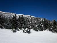
![Mt. Mansfield]() Just above my emergence from the woods.
Just above my emergence from the woods.
Hugging the margins of the run I moved quickly upward, knowing that I had burst out of the trees at about 3,000’ elevation. Soon the gondola summit, the unloading station area and building housing the Cliff House Restaurant appeared above me. Oh, yeah! One hundred yards and I was there. One hour and twenty-two minutes was my elapsed time. The GPS, AA batteries fighting the cold but still powering the Garmin unit, read 3,694’. The wind was still mostly a breeze, but on occasion I had felt stronger gusts while plying the Chin Clip run. There was definitely no heat wave today.
But now where? Everyone here was a skier and they seemed to be headed down, every one of them. I ducked into the shelter where the gondola cars made their mechanical 180s and asked the fellow in charge of unloading the passengers how I might reach the summit. Reluctant to give specific directions – probably because of possible liability issues – he remarked that there was a boot pack just to the north, next to the ski boundary sign suspended from an orange rope, and I might investigate that possibility.
That was good enough for me. Yup, the boot pack was there, leading up a short embankment and into a narrow pathway through trees standing guard along the northern edge of the gondola shelf. Tracks then angled north around a bouldered corner and began marching northwest up a wide gully bordered on its south side by rock outcroppings and on its north by a mix of small conifers and occasional boulders protruding from the deep snow. I would discover later that this is referred to by some as the “gondola trail.”
![Mt. Mansfield]() The boot pack tracks led into the slot in the trees.
The boot pack tracks led into the slot in the trees.Summit crest, summit, return to gondola summit
The boot pack varied between a course straight up and switchbacks to the crest of the mountain. The climb to the flattish summit ridge took all of thirty minutes. At the top the rime ice was in full bloom, covering every rock, tree and protuberance with myriad jagged crystals, like miniature pearly-colored silken sails standing at horizontal attention in a stiff breeze. Random northerly gusts of wind stung my cheeks as I defensively snugged my black cap toward my collar
![Mt. Mansfield]() A frozen sign on the west side of the summit crest.
A frozen sign on the west side of the summit crest.![Mt. Mansfield]() Looking north I saw that (a) it was cold and (b) the summit was not far.
Looking north I saw that (a) it was cold and (b) the summit was not far.
Directly across from where I had gained the ridge I spotted a wooden sign, and I felt I had to check it out before turning north for the short jaunt to what must be the summit. Large capital letters said, “Sunset Ridge Trail,” and underneath in smaller letters the distances of 2.1 and 3.1 miles were ascribed to the CCC Road and Underhill State Park respectively. There was another sign on the west side of the post, but by then I was feeling the full effects of being out in the teeth of the capricious winds, and decided to focus on reaching the top before risking the loss of my warmth. Climbing the steep gondola trail had kept me warm, but up here the gentle tilt of the final 150 yards was doing nothing to generate heat. Snow up here was hit and miss, the winds having undoubtedly carried most of it to far flung less exposed destinations on the mountain.
Five minutes later I was unshouldering my pack and leaning it against the summit cairn. There was no sign to indicate that this was the top, but I glanced north and south to make sure that I was on the highest spot of real estate; I was. My back to the wind and without hesitation I dug my tripod and homemade summit sign out of my pack, extended the tripod legs, fished my Canon SD 1300 digital camera from my pocket and set it for 10-second delay. I was already shivering, so I intuitively deep-sixed any idea of trying to eat or drink up here. That could wait.
![Mt. Mansfield]() Summit photo complete with homemade summit sign.
Summit photo complete with homemade summit sign.
I managed to take four pictures, the off-and-on winds twice blowing over my feather-light sign a split second before the shutter mechanism took the picture. I captured a 360° video view, holding the camera as steady as my trembling hands would allow, and then made haste to stow the sign, tripod and camera. Pack re-seated on my back and doing a quick visual sweep to make sure I had all of my stuff, I started back along my path to the gondola trail. After several yards I looked toward my destination on the summit crest and saw – no, it couldn’t be! – the young man whom I had met earlier in the Nordic Barn. Now I ask you: what are the chances?
He may have been as surprised as I was when he recognized me. We stopped and smiled about the coincidence, wished each other luck on the remainder of the day’s activities and waved goodbye. I had no trouble finding the spot where I had gained the ridge and began scurrying down, careful to avoid ruining the boot pack. Wherever possible I moved north of the boot pack, the untracked deeper snow allowing my snowshoes ample purchase for a controlled descent. As I tracked downward there must have been two dozen people, skis resting on their shoulders, making their way up the boot pack.
Back to the TH: Making new trails
![Mt. Mansfield]() Looking up from below the gondola on the east edge of the Chin Clip run.
Looking up from below the gondola on the east edge of the Chin Clip run.![Mt. Mansfield]() Back at the gondola summit.
Back at the gondola summit.
I was standing at the gondola staging area less than 25 minutes after leaving the summit. Activity there had not abated; skiers were streaming forth from the shadows of the unloading area, jabbering and putting on gloves and snapping into bindings, fully enjoying the beautiful day Mother Nature was offering. I could not have agreed more, but I spent little time being smug about it. I headed down, reversing my ascent route and plunged back into the forest after ten minutes of walking the snowier edges of the upper Chin Clip black diamond route.
Once back in the “Forest of Confusing Trails” I first elected to follow the ski tracks which were familiar to me. However, it was soon apparent that I really only needed to head down and east, and sooner or later I would emerge on the Smugglers Notch road. This way down was far better than any established trail for I could take advantage of the untracked snow and plunge step quickly but safely. Two or three skiers swooshed down in my vicinity, but for the most part I was alone and feeling wonderful.
![Mt. Mansfield]() A curious sign along the route I "forged" down.
A curious sign along the route I "forged" down.
It took all of thirty minutes to reach the road. I knew that I must be very close to the actual TH, so I walked south with a family from Montreal. We had scarecely time to introduce ourselves before I saw the familiar TH sign. As I signed the trail register I noted that the elapsed time from the summit had been a mere 1+09, and in fewer than five more minutes I was back at the car trying to remember where I had stashed the car keys.
It had been a fulfilling experience. I had been blessed with a spectacular day, a day about which one dare not complain. As another family in a mini-van pulled into the parking spot next to me, I was able to answer their questions and give the father my hand-warmer pouches which were still generating plenty of soothing warmth. Down at the parking lot there was only a whisper of wind and the sun still shone brightly.
Let’s see, my round-trip elapsed time was 3+48 which included taking time to sign in and sign out at the register, take pictures, snoop around the “let’s-lose-the-trail” area, ask directions at the gondola, do a hasty summit photo shoot, hobnob with my Nordic Barn acquaintance and make a new trail through the forest during the descent. Not all that bad. The notion flitted through my mind to do it once again, just for fun, but I quickly re-grounded myself in hard-core reality and opted to take a few more pictures and call it a day.
![Mt. Mansfield]() From atop the parking lot snow banks I take one last shot of my new friend.
From atop the parking lot snow banks I take one last shot of my new friend.Epilogue
The winter ascent of Mt. Mansfield was now personal history and I was fully satisfied with the result. It had taken two attempts for me to be successful, and I would highly recommend a winter milieu for others sizing up this state highpoint. My caveats would, of course, include checking and double checking the weather. The pleasantry of my experience resulted in large measure from the favorable skies and moderate winds. So with a light heart and a resolve to perhaps try this one again – in winter – I drove back to Burlington where my wife and I chowed down on one of the best “victory” dinners I have ever consumed: a veggie deep dish pizza from the Pizzeria UNO on Shelburne Road. Guten Appetit!


Comments
Post a Comment