Planning a successful trip
As a 17 year old kid, it's often very difficult to find people to go into the mountains with me. Luckily both my parents enjoy hiking, and my dad has some mountaineering experience. Over the years we've done a few peaks here and there, but nothing to the caliber of Mount Constance. So when my dad mentioned that he might be interested in climbing Constance, I jumped on the idea. He had climbed it a few times, the last being around 1990, so he was somewhat familiar with the route. The forecast looked OK, he was able to find some time off work, and with some insistence we got my mom's permission to go. Everything seemed to be in our favor.
The worst part of the climb: The approach
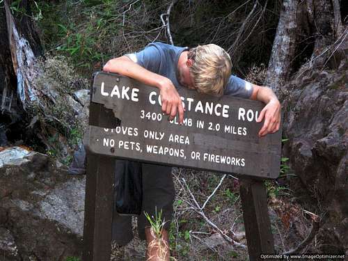
We arrived at the washout in the early afternoon, shouldered our packs and hopped on our mountain bikes. We had about 4 miles and 900 feet of elevation gain of biking to the trailhead. The grade was steadily uphill, and balancing on a mountain bike with a 35 pound pack wasn't an easy task. After about 45 minutes of biking, we reached the trailhead, completely out of breath. My quads were already burning and we hadn't even started the climb yet! We joked that the ride was enough of a climb in itself. After soaking our feet in the small stream, we stashed our bikes and began the hellish ascent of the Lake Constance "trail." (Although most people refer to it as a trail, note that the sign says "route," which seems to be more accurate).
![Before the climb]()
In the two hours that it took us to make it to the lake we had to deal with loose rock, nettles, and exposure. At one point I had to use some serious veggie belaying to prevent myself from peeling off the trail and falling hundreds of feet into the valley below. Finally, we made it to the campsites on the north side of the lake and set up our tent.
![Lake Constance]() Lake Constance
Lake Constance![Camp]() Camp on the lake
Camp on the lake
Just before it got dark, the clear skies gave way to thick fog that descended to the level of the lake, an eerie contrast from the scene just minutes before.
The Climb
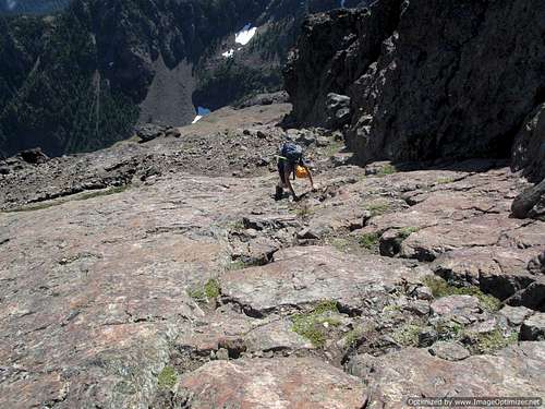
We awoke at 5:30 AM with perfect weather. Excited for the climb ahead, we wolfed down our breakfast, packed our packs and got to work. The first part of the climbers path crosses scree and boulders as it meanders its way through Avalanche Canyon. The scenery was spectacular; all around there were huge basalt cliffs and house sized boulders.
![Avalanche Canyon]() Avalanche Canyon
Avalanche Canyon![Big cliffs]() Big Cliffs
Big Cliffs
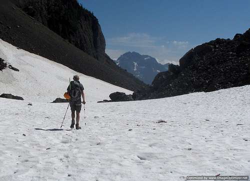
Once we reached "the thumb", a large rock formation on the west side of the canyon, we angled our way up a scree chute towards the Cat's ears. Near the top I found it easier to scramble along the right side of the chute, which contained more solid rock than the middle. We crested the chute and were greeted with a view of the Puget Sound and the Cascades. Although the sound was socked in, visibility was great above the clouds and we were able to see all the way to Mount Stuart clearly.
We dropped down a few hundred feet down a gentle snow slope and then angled north up another scree chute. The scree was very loose here, and it seemed to take forever to reach the top. Once we did, we were faced with a large snow finger we needed to descend. It looked doable with crampons and self belaying, so we donned our crampons and began to go down. Soon however, it became clear this wasn't going to happen. The snow was ROCK solid. Even my brand new crampons were barely able to get any purchase at all in the ice, and my axe wouldn't sink in more than an inch. Both me and my dad agreed that this would only be safe with a belay. My dad rigged up an anchor with webbing and rock, and slowly belayed me down the slope. Near the end it got very steep, around 60 degrees, and he was mostly lowering me since I still couldn't get much use out of my crampons. When I got to the bottom I spotted a narrow, east facing rock rib next to my dad. I yelled up to him that it looked climbable, and he agreed. He made quick work of it and soon was on the other side. I ascended up steep snow (luckily, not as solid as before) and we both wondered how we hadn't thought of scrambling in the first place.
![Descending snow finger]() Descending snow finger
Descending snow finger![My route down snow finger and my dad s]() My route down the snow finger is in red, my dad's route over the rock rib is in blue.
My route down the snow finger is in red, my dad's route over the rock rib is in blue.
We traversed some exposed ramps and soon found ourselves at the beginning of the "finger traverse." The first move, getting into the crack, looked like solid class four with huge exposure. I was confident I could do it but my dad said he wasn't comfortable with me trying it, as a slip would likely mean death. Luckily I brought along a route printout from summitpost that described a variation called the FT Bypass. The first move descended a west facing chimney (on the west side of the rock that the finger traverse is on) and from there traversed about 50 feet of exposed ledges to meet up with the end of the finger traverse. Although this was only class 3, knowing that a fall would put me thousands of feet down in Avalanche Canyon was a sobering feeling. Carefully, we made use of the plentiful handholds for balance and worked our way down the ledge to meet up with the standard route.
![FT Bypass]() FT Bypass
FT Bypass
From here, we plunge stepped and glissaded down steep snow to meet up with the ramp used by the "Terrible Traverse" route. We walked up the ramp and slowly contoured our way around to the northeast side of the mountain. From here we scrambled up some class 3 rock to meet with the summit block. Routefinding is tricky here; make sure you know where you are going and take it slow.
![Getting close...]() Heading around to the summit block
Heading around to the summit block![Climbing class 3 rock near the summit]() Climbing class 3 rock near summit
Climbing class 3 rock near summit
At the block we ditched our packs and picked our way up the class four rock to the summit. Luckily these moves weren't as exposed as what we'd faced previously, and in no time we were on the summit. I couldn't believe it. For as long as I can remember I've looked at this mountain, fantasizing about climbing it but doubting I would ever be able to do so. It was a great feeling for both of us, especially my dad. He'd been worried about being able to make it, but surprised himself by having no trouble at all in any parts of the route. In fact, it was only five hours from the time we left the campsite to the time we arrived at the summit. Kudos to him for taking me on this trip, I definitely wouldn't have made it without him.
![Climbing summit block]() Climbing the summit block
Climbing the summit block![One more move...]() The last few moves
The last few moves![Sitting on top]() Sitting on top
Sitting on top![My dad on the summit]() My dad on top
My dad on top
Downclimbing the block was tricky but we managed, and from the top of the second chute (with the snow finger) to the lake was incredible scree skiing. In no time we were at camp.
![Going back up]() Heading back up towards FT Bypass
Heading back up towards FT Bypass![Heading out]() Heading out
Heading out
By the time we broke camp and shouldered our packs we wanted to be done, but we knew an awful descent awaited us. After carefully climbing down the exposed parts of the trail we practically jogged back to the trailhead, making it down in about an hour. Biking down the road was incredible, and five hours after making the summit and over 7,000 feet lower we arrived at the car, completely wiped but happy for a successful climb.
Summit video
https://www.youtube.com/watch?v=GokY69jB1s4


Comments
Post a Comment