

|
|
Mountain/Rock |
|---|---|
|
|
31.90300°N / 106.493°W |
|
|
7192 ft / 2192 m |
|
|
Overview
The Franklin Mountains are located in El Paso in far West Texas. The range neatly cleaves the city of El Paso, and the highest point, North Franklin Mountain, offers incredible views out over the stark West Texas - New Mexico desert scape. This peak is also the highest point in El Paso County, Texas, and ranks fifth on the Texas prominence list.
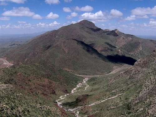
North Mount Franklin © 2006 Brian M. Stansberry http://stansberry.vorvax.com Used with permission
Getting There
The trailhead is located on the west flanks of the range in the Franklin Mountains Preserve. Easiest way is to exit Interstate-10 onto Loop-375 (I-10 exit 6) and drive east about 4 miles to the gate and entrance to the park on the left (north) side of the road. It is well marked and the only sign of civilization along this stretch of road. Follow this road about 1 mile, then turn right. (You may see signs to Mundy's Gap.) After a short distance, you will arrive at a parking area with a trailhead kiosk.
Loop 375 can also be accessed from the east side of the city, but it entails a long drive through Fort Bliss.
Loop 375 is a nice drive for scenery and there are pullouts for picnicking and viewing along the high part of the road. There are other hiking trails in the area as well.
Red Tape
No permits are required, but there is a fee for entering the park (currently $4 for persons over 13 and older). The Tom Mays unit of Franklin Mountain State Park does have "hours" - 8 to 5; a gate will lock you in, so you'll have to time your visit around then.
When To Climb
The mountain can be climbed all year. According to the El Paso Weather Bureau, the sun shines 302 days a year here. Surgent climbed it on December 31, 1999 in very pleasant conditions with just a hint of snow. Most winters, the El Paso area experiences one or two days of light snowfall.
Spring can be very windy – routinely winds will be sustained at 30-50 miles per hour. The wind can kick up dust that reduces visibility severely and even cause the only access road to the State Park (TransMountain/Loop 375) to be closed. Spring can also be one of the most beautiful seasons, particularly when the winter has been wetter than usual. Mexican poppies bloom, turning the east slopes of North Mount Franklin into a golden carpet.
Summer (May through September) can be extremely hot, with temperatures often above 100 degrees Fahrenheit (38 degrees Celsius). The whole route is treeless and exposure to the sun could be a concern. Be aware of summer thunderstorms that are common most afternoons in late June, July, and August.
Fall is a perhaps the best season to hike. October highs, for example, range in the mid-70s to low 80s. Winds are calmer and precipitation is light.
Camping
There is limited camping and RV space, but it is relatively primitive. Bush camping outside the park does not seem to be a viable option if you want to stay close to the park. Suburbia comes right up to the park boundaries on both sides of the range, then there's the vast expanse of Fort Bliss. On the other hand, there are tons of cheap, decent hotels in El Paso and Anthony (on the state line along I-10).
Mountain Conditions
Extremely heavy rains in the summer and fall of 2006 have damaged the trails in Franklin Mountains State Park.
External Links
Check out:
Franklin Mountains State Park Offical Website
Geology provided by UT-El Paso
Wikipedia entry This page has great photographs of the mountain.
dsnell - Aug 22, 2003 4:53 pm - Voted 10/10
Untitled CommentMount Franklin is located in the massive Franklin Mountains State Park, a recent addition to the Texas State Parks system. In addition to the hike up Mount Franklin, visitors can enjoy about 51 miles of excellent, challenging single track mountain biking trails. There are also a number of one-pitch sport climbs in the park. Of course, Hueco Tanks State Park is also in the area.
From afar, the Franklin Mountains appear to be brown lumps of lifeless rock. Up close however, you will find them to be full of interesting Sonoran desert flora and fauna, including Ocotillo, Spanish Dagger and other interesting desert plants.
It's hot as Hades here in the summer, but you can still enjoy the park. Just bring a lot of liquids.
grunt - Jan 22, 2006 12:44 pm - Voted 8/10
Untitled CommentThe new link for the park is http://www.tpwd.state.tx.us/spdest/findadest/parks/franklin/
surgent - Feb 28, 2006 4:53 pm - Hasn't voted
Re: Untitled CommentI made the change! Thx for bringing it to my attention. -SAS
Sarah Simon - Dec 2, 2009 10:46 am - Hasn't voted
Getting There SectionHello. I just summitted North Franklin a few days ago and wanted to provide some additional information to help out-of-towners find the trailhead (in bold, below, augmented to your existing directions). The trailhead is located on the west flanks of the range in the Franklin Mountains Preserve. Easiest way is to exit Interstate-10 onto Loop-375 (I-10 exit 6) and drive east about 4 miles to the gate and entrance to the park on the left (north) side of the road. It is well marked and the only sign of civilization along this stretch of road. Follow this road about 1 mile, then turn right. (You may see signs to Mundy's Gap.) After a short distance, you will arrive at a parking area with a trailhead kiosk. Cheers, Sarah
grunt - Dec 20, 2009 12:54 am - Voted 8/10
Re: Getting There SectionThanks, I'll add it!
jbp28 - Feb 18, 2015 5:58 am - Hasn't voted
Franklin Mountains Tragedy In the MakingUrban sprawl and development are rapidly consuming this beautiful desert mountain range. A new freeway was just put up going through the middle of the range causing the closing of the park entrance. As far as I know a new entrance has yet to be made. New neighborhoods are within less than a mile from the park. The west side of the city has already developed as far up the west side of the range as possible, mainly gated communities. Westward development is almost at a beautiful sight seeing area next to South Franklin Mt. This area people can park, picnic and in the past enjoyed beautiful desert views and views of west ELP in the distance, however now, development is closing in and within a few years only roofs of homes will be viewable. Also, the main portion of the park which includes North Franklin MT., biking paths, camping area, rock climbing, and picnic tables is rapidly being closed in on by new community developments. On the East side of the mountains the famous Tramway & Mckelligon Canyon are also in danger. A large quarry sits right next to the Tramway and also next to the canyon entrance and this quarry is getting larger & larger every year. It is digging deeper into the range and it has already destroyed the aesthetics of Mckelligon Canyon and the Tramway. Sugarloaf Mt. already has a huge gash at its base due to this quarry. I believe developers want to envelope the park into their plans. New gated communities would conjoin the park much like in the west side of the range. It would be a good selling point for land developers that's for sure. These new communities would basically have the park as a backyard. Easy access to all the parks ammenities and they would probably develop there own private entrance. Please go this petition and sgn up to protect these mountains from further damage before it is too late! Download and print the documents below and get started today. For more information contact Jim Tolbert by email at diegotolbert@gmail.com or call 915-525-7364. http://www.iloveparks.com/fmwc/2015p.pdf
T. White - Jun 25, 2023 10:34 pm - Hasn't voted
Re: Franklin Mountains Tragedy In the MakingSad to hear that the tramway is now closed indefinitely.