Previously in Four months in Peru: Urus Central: To boldly err where no man has erred before.
Prologue
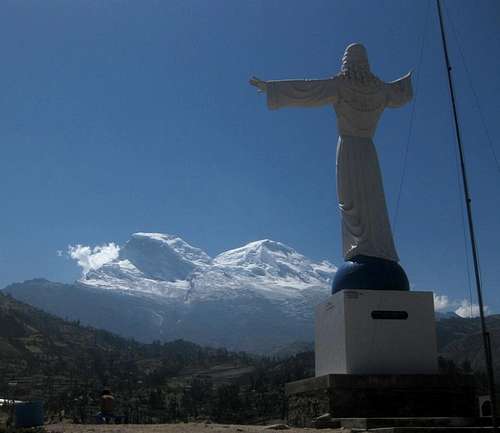
![Yungay memorial]() The a big Jesus statue, memorial for the 1970 disaster, looking at Huascarán
The a big Jesus statue, memorial for the 1970 disaster, looking at HuascaránThe history of the city of Yungay is a sad story. In 1970, a big earthquake hit the north of Peru, and one of its dramatic effects was to dislodge a big mass of ice high on the slopes of Huascarán Norte. As it came crashing down, it developed into a massive avalanche, gathering more and more energy on its destructive path. A few minutes after it started, the debris reached Yungay and almost completely buried it, killing 20 000 people.
Today, a big Jesus statue at the cemetery serves as a sober memorial. The town has been rebuilt a few kilometers further away, hopefully safe from similar future disasters. The new buildings are bright, but the town still has a more subdued feel to it than the lively city of Huaraz.
An inauspicious start
Eric and I planned to climb Yanapaccha and Chopicalqui, but we had left Huaraz too late to head into the mountains the same day. Yungay is much closer to Yanapaccha, so we traveled there instead, so we would have a shorter ride to our trailhead in the mountains tomorrow. We checked in at
Hostal Gledel, reportedly the best place to stay in town, charging 10 Soles (about 3.50 US$) for a bed for the night. It was a bit spartan but clean, and the hosts would prove to be very friendly and helpful.
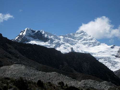
![Yanapaccha from the west]() Yanapaccha as I had seen it a couple of weeks before, from near the Pisco refuge to the west. The south peak, on the right, is the main one. The glacier looks pretty wild from here, but up close it would prove to be not too bad.
Yanapaccha as I had seen it a couple of weeks before, from near the Pisco refuge to the west. The south peak, on the right, is the main one. The glacier looks pretty wild from here, but up close it would prove to be not too bad.Soon after our arrival, I heard that Eric had left his wallet in a shop. At first I thought it was in the shop belonging to the same friendly family that operated our hostel. I somehow got the impression that they told me because they had found it and wanted me to help locating Eric, but as the clouds lifted, I got the real story: he had left it all right, but in a different shop altogether, and it was actually him who had told the family.
He had laid down his wallet only for a short time before he noticed it was gone. There were just a few people around that could have taken it, but, unsurprisingly, nobody knew anything, everybody played ignorant. He enlisted the help of the sympathetic hostal owner, but that didn't bring the required result. Now he suddenly faced a different kind of challenge than climbing big mountains: he was stranded in Peru, without cash or credit card.
He filed a police report. They were friendly, and went on to investigate, but nobody admitted anything and there wasn't much they could do. Eric called his credit card company to block his card, and his family back home to send over some money. In the mean time I lent him some to tie him over.
Next morning, he checked with the police, but they had no result yet. Later, when he got in touch again with the credit card company, he learned that someone had indeed tried to use his card at the local ATM. Unfortunately there were no camera images, so the investigation reached a dead end.
While this was going on, I figured that any development would take time, it didn't seem likely that there would be an instant result. And so I proposed we might as well do what we had come for, and go climbing. Besides, it would take Eric's mind off his misfortune. And so, early afternoon, we finally headed off.
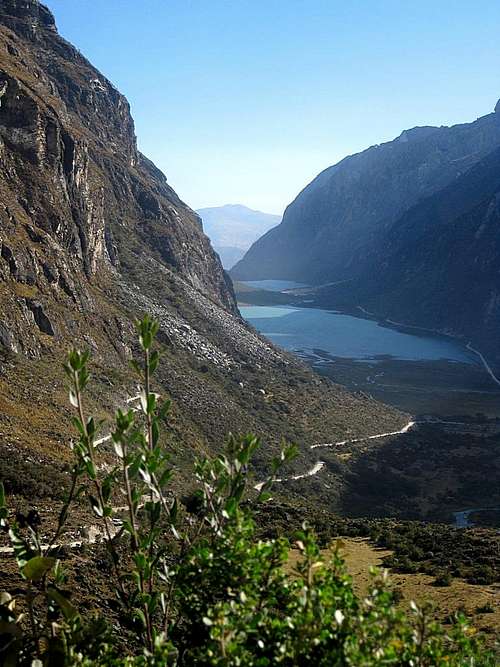
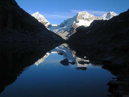
![Llanganuco lakes]() Looking back at Llanganuco lakes from the road above
Looking back at Llanganuco lakes from the road aboveOur approach would lead us past the Llanganuco lakes, near the entrance of the valley bearing the same name. As it happens, these lakes are very popular with the Peruvians, especially on holidays. We didn't know about it, and in Yungay nothing special seemed to go on, but it happened to be the Peruvian Independence Day. Cars were parked everywhere alongside the road, and since it wasn't wide to begin with and dealing with traffic coming from the other side, it took a lot of time to get past that bottleneck.
Now, the guidebook descriptions to base camp for Yanapaccha are a bit confusing. John Biggar
[1] describes the old route, but Brad Johnson
[2] mentions there is a newer one. However, he gives it 3-4 hours from the trailhead to base camp, and from looking at the map, that seemed a lot. Fortunately I had met other climbers in Huaraz recently, who had assured me it was indeed much shorter.
Brad Johnson writes that the trailhead is at the curve just past marker post 42km. I explained that to our taxi driver, repeatedly stressing the "cuarenta y dos kilometros" part, and, as the book instructed, I watched the markers go by as we gained altitude on the winding road. Shortly past the 40km mark the driver declared that we were at the trailhead. I didn't see a trail, and we still had to go two more kilometers, and, more importantly, get higher. I said that we were not yet past the 42km mark, and that I wanted to go further. He was reluctant, but complied anyway. I have no idea why he was acting like this – I was convinced that I had been very clear where I wanted to go.
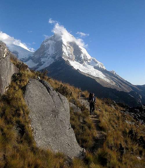
![Eric on the trail to Yanapaccha]() Eric on the trail, with Huascarán Norte in the background
Eric on the trail, with Huascarán Norte in the backgroundA bit higher we got to the 42km marker. It was right before a bend in the road, and Eric got out of the car to have a look. There was a vague trail going up, so he followed it to see where it would go. As it happened, it was just a shortcut, coming back to the road again two bends higher, which is where he found a more promising trail. We had found the trailhead, three bends after the 42km marker. Our driver didn't object anymore, but duly delivered me and our two heavy bags, and so Eric and I could finally start hiking.
It was pretty late by now, already after half past five in fact. I really hoped that Brad's book was wrong and the climbers I had met in Huaraz where right, because we had less an hour and a half of daylight, and although it's easy to forget when you're surrounded by massive glaciated peaks, Peru lies in the tropics, total darkness arrives swiftly after that. The route was clearly well-used, making it easy to follow. It traversed the northern slopes of a big ridge extending roughly west to southwest from Yanapaccha, with a few ups and down. The road would continue to a high pass on the other side of that same ridge. We started out together, but after a while I went ahead, trying to make the most of the daylight we had. In 1½ hours I reached base camp, right around sunset. The climbers in Huaraz had been right.
It was a beautiful place, with a small tranquil lake providing water, and a few places where you could pitch a tent. There were two already. I put the last light of the day to good use and quickly set up camp too. Eric arrived half an hour later. Because of our late start, we had to do filter water and cook dinner in darkness and while it was getting colder, both of which made everything slower. As a result, it was 9 o'clock by the time we finally turned in. Pretty late, but we couldn't care less: we were camping in the mountains again! Since the forecast promised excellent weather, we decided to forego the alpine start that is normal for Yanapaccha, and planned to get up at 6, around daybreak. As a bonus, we would be able to see where we were going right from the start.
A glorious day
![View from the Yanapaccha camp site]() The view from our camp site, early in the moring. Huandoy Este and Pisco early in the morning from our camp site
The view from our camp site, early in the moring. Huandoy Este and Pisco early in the morning from our camp siteWe got up shortly after 6, right on cue for a glorious view to the mountains on the other side of the Llanganuco valley. By half past seven we were moving. We soon spotted a couple of climbers on the slope leading up to the crest of the NW ridge, the steepest bit of the route, not far from the summit. They must have started early.
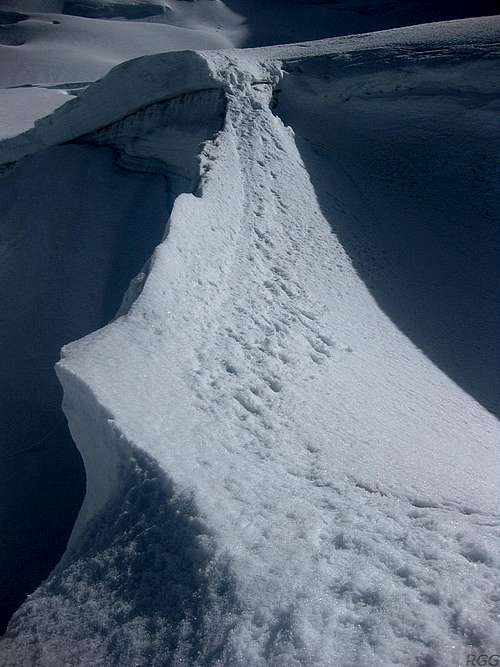
![Snow bridge on the route]() Snow bridge on the route
Snow bridge on the routeTo get to the edge of the glacier, we had to go over a small ridge with some very big boulders tossed around haphazardly. There were cairns marking the route, but with an alpine start it would still have been tricky to find the right way. In daylight it was easy and soon we got to the edge of the glacier.
We took our time getting geared up, but after that we made good progress. It wasn't steep, and we had a wide trail to follow. Route finding wouldn't be any problem today.
Occasionally we saw a crevasse. Mostly they were babies, there were only a few bigger ones. The snow bridges looked very solid though and while we crossed them one at a time, we didn't set up a belay.
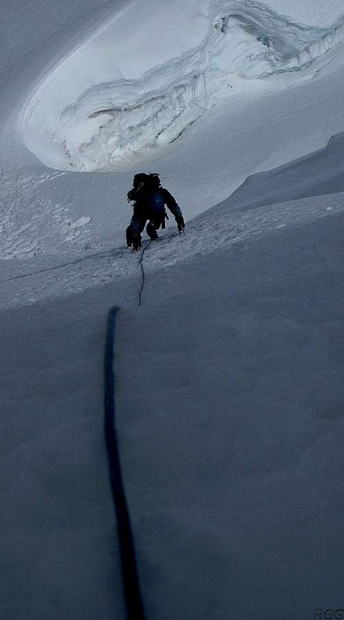
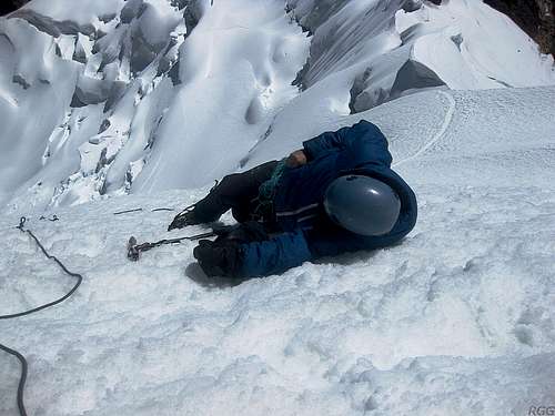
![Eric on the crux]() Eric on the crux
Eric on the crux
As we were making our way up the gentle slopes, we saw two other climbers struggling on the steep slope. They were descending, but I was thinking they were extremely slow and the lower one looked out of his comfort zone. Soon after we met them, and learned they were a local guide with a Swiss client. And it wasn't the guide that was so slow. Nevertheless, the Swiss guy looked very happy, elated to have made it to the summit. He went on to explain that the slope was about 80m high and 60º steep, and from the crest it was only half an hour along the ridge to the summit. That, in turn, made me happy, because that was less than I had thought. And since we knew that it might be steep, we had come prepared and brought two ice tools each.
We had a ball going up the steep slopes, it was great fun. There was no hard ice; it was solid snow, which gave excellent purchase. I went up first, but, knowing it would be too long to climb it in one pitch, I went up until I came to a spot that was marginally less steep. On one snow stake, and using my two tools hammered into the slope as backup, I belayed Eric. From there, the rope was long enough, so I climbed straight to the crest. I estimate that the steepness of the slope was somewhere between 50º and 55º, with the higher part being the steeper one.
Those two steep pitches had put us on the crest of the NW ridge, directly to the right of a large mushroom of snow and ice. Although we had it easy, only having to follow the clear big trail, someone must have been the first to make it. The choice of route was obvious though. As we had seen lower down, the shortest route, directly to the summit, up the steep western slopes, was too dangerous because of seracs hanging high up there. That left the NW ridge as the next best option. And while it would have been easier to get up on the ridge further from the summit, that would have meant having to deal with the big mushroom blocking the ridge. By gaining the crest on the right side of the mushroom, we didn't have to go around it anymore.
We had a break and enjoyed the scenery from up on the ridge. The view of neighboring Chacraraju was especially impressive. I know I'll never climb it – too difficult for me, and even if I could, too dangerous – but it certainly looked awesome!
![Chacraraju from the summit ridge of Yanapaccha]() Chacraraju seen from the ridge, with the big mushroom in the foreground.
Chacraraju seen from the ridge, with the big mushroom in the foreground.
See that backpack lying there? It puts the size of the mushroom in perspective.![The summit ridge on Yanapaccha]() Looking across the NW ridge to the summit, with half an hour to go
Looking across the NW ridge to the summit, with half an hour to goWe could see almost the whole route along the ridge to the Yanapaccha summit from where we were standing. There appeared to be the occasional short steepish section, but, by the looks of it, nothing serious. I suggested Eric that he could lead, and so we continued on our way. Sure enough, with the accuracy of a Swiss watch, we reached the top half an hour later.
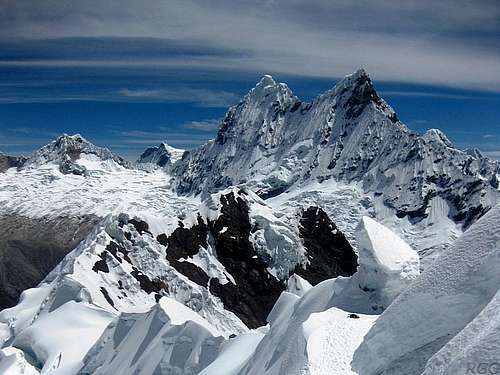
We were happy to be up there - probably Eric even more so than me, as it was his first summit on his trip to Peru. Once more the views were breathtaking. Yanapaccha reaches the respectable altitude of 5460 meters, but all around there were majestic mountains of more than 6000 m towering above us.
Terrain map of Yanapaccha and the surrounding area
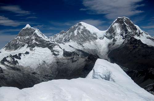
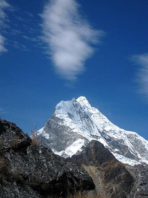
First and foremost, to the south lie the Huascarán peaks, the two highest summits in Peru. I had climbed Norte (6655m) a few weeks ago, but with Sur (6746m) at the top of my wish list, I look at it with more than just casual interest. Norte actually apppears higher, but that's just because it is closer. Much closer still, left of Sur, is our next goal, Chopicalqui (6345m). From Yanapaccha it doesn't look much lower than Huascarán Sur. But again, first impressions are deceiving; Chopicalqui is the nearest, and therefore it doesn't look like it is 400m lower.
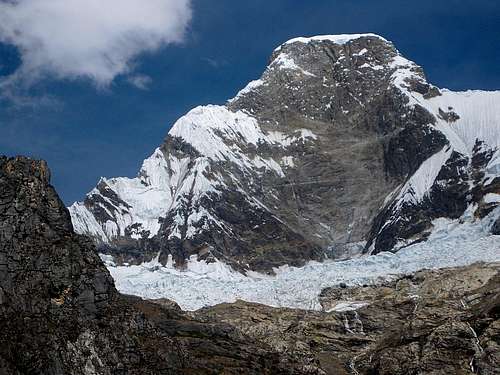
To the west, about the same distance as Chopicalqui, lies the equally impressive Huandoy (6395m). That's a huge mountain, with four distinct peaks that remind me of a crown. Three of the four are higher than 6000 m. I had seen it up close when I decended neighboring Pisco (5722m), but it looks just as beautiful from further away. Finally, to the northwest lie the very steep and dangerous Chacraraju twins, also topping out over 6000m. As if defying gravity, the snow somehow sticks to the near vertical face - which seriously adds to the danger, for occasionally it comes tumbling down.
All in all, that makes eight peaks over 6000m close by - and then I'm not even starting on the rest! It sure is a magical place, the Cordillera Blanca, and there is hardly a better place to enjoy it than on top of of a mountain. Not necessarily the highest ones, mind you – looking up and around from the top of the somewhat lower ones can make at least as big of an impression.
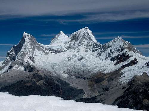
![Chopicalqui and the two Huascarán peaks]() Chopicalqui and the two Huascarán peaks, Sur and Norte
Chopicalqui and the two Huascarán peaks, Sur and Norte
| ![Huandoy]() Huandoy - from left to right are Sur, Oeste, Norte and Este
Huandoy - from left to right are Sur, Oeste, Norte and Este
|
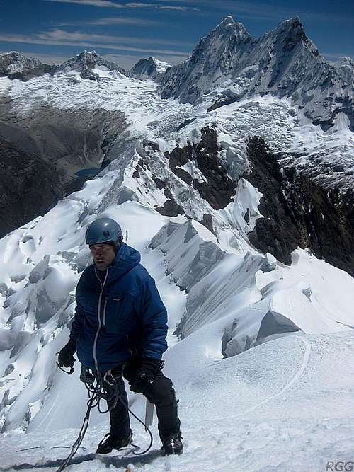
![Eric on Yanapaccha, with Chacraraju in the background]() Eric on the summit, with Chacraraju in the background
Eric on the summit, with Chacraraju in the background![One very tired climber on Yanapaccha]() One tired climber on the summit
One tired climber on the summitStill, although the forecast came true and the weather was excellent, we couldn't stay up there forever. As we started our descent, I thought that if we would be fast, we might have enough time to get all the way back to Yungay. But while we were not slow, we were not quite fast enough either. It didn't help that we lost a bit of time on descending the steep slope. On our way up, we had left a snow stake half way up there, so Eric could rappel from it while I climbed down. I would climb down the slope so we wouldn't have to sacrifice any gear. However, as I lowered Eric from the crest, he didn't see the stake and went past it. Fortunately, when the rope was fully extended, it wasn't quite as steep as higher up, so he could safely wait for me there. I tossed the rope to him, and started my way down.
Along the way I picked up the stake – as I was climbing down, I could see a reflection in the sun from far above. By the time we were together again, we weighed our options. Because it was not quite as steep anymore, we agreed that we didn't need to rappel the bottom part of the slope after all, we could both climb down.
By the time we reached the gentler slopes of he glacier, Eric was tired. I have to admit that I pressed on a bit, thinking that we still had a chance of making it to Yungay. We did all right on the descent, but were not quite fast enough.
By three o'clock we were back at our tent. Eric still thought we would pack up and continue, but I replied that it was too late for that. I reckoned that if we would pack up right away, we might make it to the trailhead somewhere after five o'clock – given that we were tired, it would probably be closer to six. Now that may not seem very late, but with the short days of the tropics that would put us there around sunset, and I reckoned it would be difficult to get a lift by then – if there would be any traffic at all that late. And while we could put up our tent again at the trailhead, there would be no water anywhere near.
As I started filtering water and preparing dinner, Eric lay down in our tent to have a rest. Once horizontal, he realized how tired he really was; he didn't even have the energy to take his socks off. Almost two hours later he came out, to drink and eat a little, before quickly going back to rest again. In hindsight it was no surprise, really. After only a week or so in Peru, he wasn't nearly as well acclimatized as I was.
A bumpy ride back
![Yanapaccha]() Looking back at Yanapaccha, the morning after our climb
Looking back at Yanapaccha, the morning after our climbWe had all the time in the world, so we slept in. By 7:30, well after sunrise, it was still cold outside because our tent was in the shade of a small hill next to the lake. We enjoyed a leisurely breakfast with chocolate cereals, tea, coffee and instant noodles. Gradually, the sun climbed out above the small outcrop next to our tent, and that made it a whole lot more pleasant.
Shortly before 10 we were on the move again, and, well rested and well fed, we reached the trailhead in less than two hours. We waited for half an hour, hoping to catch a ride. However, while there were a few vehicles on the road, they were all going uphill, the wrong way! So maybe we should hike down instead? We had enough time for that, but it would take the better part of the afternoon to get to Cebollapampa, where I expected a taxi would be easy to find.
We felt energetic enough, so instead of just sitting around, we started moving. Mostly we followed the gently descending winding road. Occasionally we chose a steeper route, sometimes following some sort of a trail, sometimes not. The sparse vegetation didn't pose any problems, but the steepness limited our options.
After a while, we spotted a truck coming down the road, still far away, and we headed back to the road. Sure enough, for a small fee we could get a ride.Five other tourists and two Peruvian kids were already in the open back of the truck, but there was plenty of room for more. It was a very bumpy ride down to Yungay, from about 4600m to 2550m, and, taking two hours, quite slow as well, but who cares. By 3 o'clock we were back in civilization and we didn't have to do anything special that day - except to pop in at the police station.
Epilogue
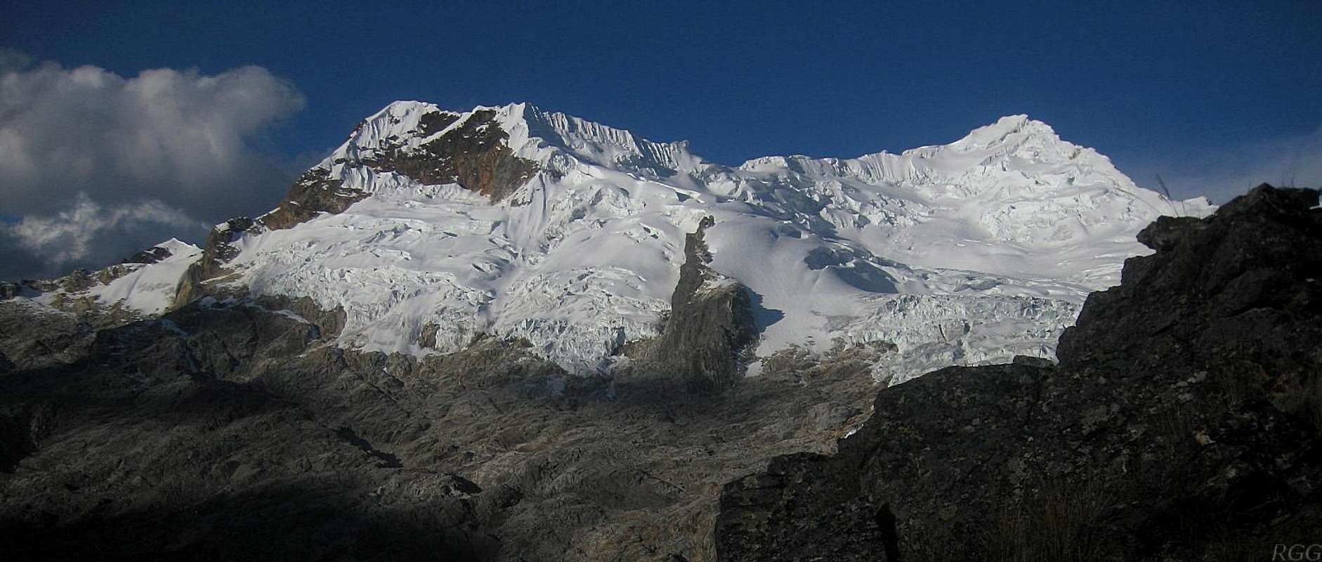
![Chopicalqui]() Chopicalqui from near the trailhead
Chopicalqui from near the trailhead![The north face of Huascarán Norte]() The mighty north face of Huascarán Norte, from the road to the trailhead
The mighty north face of Huascarán Norte, from the road to the trailheadNot surprisingly, Eric never saw his wallet again. It had been easy not to think about it in the mountains, but with that darker side of Yungay hitting home again, he decided he wasn't too keen to have a go at Chopicalqui anymore. I don't blame him.
Despite this incident, I always felt that Peru was a relatively safe place to travel. Sure, there is a bit of crime going on, but as long as you make a few inquiries about where it's safe to go and what places to avoid, you'e usually fine. You can still get unlucky, as Eric did, but that can happen to anyone in just about any country in the world. Apart from a little bit of corruption, the only noteworthy mishap that I fell victim to myself was getting separated from my rain jacket early on in my long trip – and I never found out if it got stolen or if I forgot it somewhere myself.
The story continues here: Is there a mutated strain of contagious summit fever on Huascarán?
![Yanapaccha panorama]() Yanapaccha from the southwest, from the approach hike. The north summit is on the left, the south summit, the main one, is the nice pyramid on the right
Yanapaccha from the southwest, from the approach hike. The north summit is on the left, the south summit, the main one, is the nice pyramid on the right
Notes
[1] The Andes - A guide for climbers, John Biggar. 3rd edition, 2005. ISBN 0953608727
[2] Classic Climbs of the Cordillera Blanca, Brad Johnson. 2009 revised edition. ISBN 9780975860618.


Comments
Post a Comment