This along the watershed divide Vertosan Walloon, parallel to Comba Vetan above the Town of Saint Pierre and waters which fall above Avise, Planavalle above that of the Municipalities of La Salle and Morgex. Starting from the Court de Bard, imposing bastion wooded-rocky falls on SS.26 above the Villages of Villaret, Champ, Bonne and Frenay, the dividing crest is directed towards achieving the two North Bard Pass and Borromein and two elevations of Punta Fetita, Felita and also Falita (radical that always derives from feyes, or sheep, and indicates a steep slope on which ancient times is carried out grazing); over, after a short descent on the hill of the same name, the partition continues to form the Testa dei Frà and the Testa di Serena (2.830m), maximum elevation of the coast. Here the ridge splits by sending a branch to the Northeast toward Serena Pass, Creton du Midi, Grand Creton and Aiguille di Artanavaz (3.071m) to the Northern summit of the Group of the Grande Rochère (3.326m), but this trait separates now the Comba (Basin) of Planavalle that of Merdeux in the Valley of the Gran San Bernardo. The second ramification fold instead progressively towards the East-northeast ridge forming the Cresta di Corléans, Punta Valletta, Citrin Pass and then fold in the Southeast in the direction of the two Mont Flassin, the Mont Vertosan, Monte Rosso, Punta Paletta to the Punta Aouilletta, all now included in the Subgroup of Mont Fallère (3.061m), the highest elevation of all this vast area of the Middle-Upper Valley of Baltea Stream. This last stretch marks the head and the Eastern part of Comba di Vertosan. This whole zone is very suitable for hiking but also for the Ski-mountaineering, is also suitable for hiking with snowshoes. The complete traverse, at least until the Testa di Serena, is highly rewarding panoramic being at all the peaks positioned in the center of Aosta Valley, with special and beautiful views of the Mont Blanc Mountain Chain, which dominates opposite.
Questo lungo spartiacque divide il Vallone di Vertosan, parallelo alla Comba di Vetan sopra il Comune di Saint Pierre e le acque del quale scendono sopra Avise, da quello di Planavalle sopra i Comuni di La Salle e Morgex. Iniziando dalla Court de Bard, imponente bastione boschivo-roccioso che precipita sulla SS.26 al di sopra delle Frazioni di Villaret, Champ, Bonne e Frenay, la cresta divisoria si indirizza verso Nord raggiungendo i due Colli di Bard e Borromein e le due elevazioni della Punta Fetita, Felita ed anche Falita (radicale che deriva sempre da feyes, ovvero pecore, ed indica un versante scosceso sul quale da tempi remoti viene effettuato il pascolo); oltre, dopo una breve discesa sopra il colle omonimo, il divisorio continua formando la Testa dei Frà e la Testa di Serena (2.830 m), massima elevazione della costiera. Qui la cresta si sdoppia inviando un ramo a Nordest verso Colle Serena, Creton du Midi, Grand Creton ed Aiguille di Artanavaz (3.071 m), al vertice Settentrionale del Gruppo della Grande Rochère (3.326 m); ma questo tratto separa ormai la Comba di Planavalle da quella del Merdeux nella Valle del Gran San Bernardo. La seconda ramificazione piega invece progressivamente verso Est-nordest formando la Cresta di Corléans, la Punta Valletta, il Col Citrin per poi ripiegare a Sudest in direzione dei due Mont Flassin,l Mont Vertosan, Monte Rosso, Punta Paletta, Punta Aouilletta, tutte ormai comprese nel Sottogruppo del Mont Fallère (3.061 m), massima elevazione di tutta questa vasta area della Medio-Alta Valle della Dora Baltea. Questo ultimo tratto segna la testata ed il divisorio Orientale della Comba di Vertosan. Tutta questa area è molto indicata per l'Escursionismo ma soprattutto per lo Sci-alpinismo; inoltre è idonea alle escursioni con racchette da neve. La traversata completa, almeno fino alla Testa di Serena, risulta altamente gratificante a livello panoramico essendo tutte le vette posizionate nel centro della Valle di Aosta, con particolari e splendide viste sulla Catena del Monte Bianco, che troneggia dirimpetto.
Getting There
BY CAR:
From Torino, Milano, etc: Motorway A5. Exit at Morgex.
From Switzerland: through the Grand Saint Bernard Tunnel or the namesake pass.
From France: through the Mont Blanc Tunnel or Petit Saint Bernard Pass: It is not necessary to take motorway A5: you can drive on SS.26, in the direction of Aosta. From the Morgex exit of Motorway A5, continue east for about 1.5 km along SS.26 in the direction of La Salle (994m). Take the main street of La Salle and continue along the Regional Route leading to the small Village of Morge (1.625m). After a few switchbacks, and past the Villages of Chatelard (1.061m), Remondey (1.349m) and Cheverel (1.470m), arrive to Challancin (1.610m), where you leave the car.
BY PLANE:
Aeroporto "Corrado Gex" Saint Christophe (Aosta).
Route Description
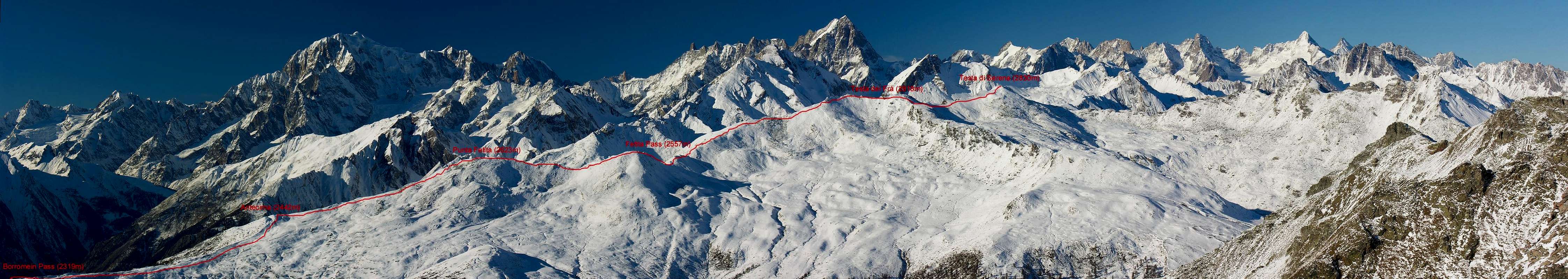
From La Salle come up with the paved road to the overlying Fractions of Croix des Prés, Cheverel (1.470m) and Challancin (1.610m; small parking lot) from this village up towards the Northeast through the path n° 2 coming to Les Ponteilles (1.731m). Abandoning the left (North) trail that climbs n° 2A to Les Ors, mostly in Southeast instead continue reaching Arpilles Pasture (1.862m; beautiful fountain), take an immediate right into the path that goes into the woods and climb with short diagonal alternating hairpin bends that back with beautiful views of the iced North Face of Mont Paramont which stands directly opposite. Crossed two small Torrents of Arpilles and Charvaz with a diagonal more "quiet" to the right to reach the Bard Pass (2.176m). From this worth making a detour to get to the South, crossing a vast grassy plateau and small rocks into the end always with the path, the bastion of the Court de Bard (2.262 meters; 2h'00). After returning to the hill and continue on the ridge dividing the North and go to the next Borromein Pass (2.319m), and always with the same kind of path, after a round antesummit 2.442 meters, the two Tops Fetita (2.623m; 1h'30 from the Col de Bard), in short it comes down to the underlying and namesake Hill (2.557m) continuing, the same direction along the Southern Crest of Testa dei Frà (2.818m) through a small trail that rises up debris, blocks and broken rocks (0h'45 from the Felita Pass; 4h'30/5h'00 by Challancin Hamlet). Easy before to get off the Ridge North-northeast and, after, in ascent through the Crest South-southwest, of easy rock routes, to reach the Testa di Serena (2830m), where the watershed Planavalle/Vertosan ends (0h'45/6h'00 in total).
Da La Salle salire con la strada carrozzabile verso le soprastanti Frazioni di Croix de Prés, Cheverel (1.470 m) e Challancin (1.610 m; piccolo parcheggio); da questo villaggio salire verso Nordest tramite il sentiero n° 2 arrivando a Les Ponteilles (1.731 m). Abbandonando a sinistra (Nord) il sentiero n° 2A che sale a Les Ors, continuare invece maggiormente a Sudest raggiungendo Arpilles (1.862 m; bella fontana); prendere subito a destra il sentiero che si addentra nel bosco e risalire con brevi diagonali alternati a stretti tornanti che lo risalgono con bella vista sulla ghiacciata Parete Nord del Mont Paramont che si staglia proprio di fronte. Attraversati i due piccoli Torrents de Arpille e Charvaz con un diagonale più "tranquillo" verso destra si raggiunge il Col de Bard (2.176 m). Da questo merita effettuare una digressione verso Mezzogiorno per raggiungere, attraverso un vasto plateau erboso e piccole rocce nella parte terminale sempre con sentiero, lo spalto della Court de Bard (2.262 m; 2h'00). Dopo essere ritornati al colle si continua sulla cresta divisoria con direzione Nord raggiungendo il successivo Col Borromein (2.319 m) e, sempre con lo stesso tipo di percorso, dopo una arrotondata antecima 2.442 metri, le due Punte Fetita (2.623 m; 1h'30 dal Col de Bard); in breve si scende al sottostante ed omonimo Colle (2.557 m) proseguendo, stessa direzione, lungo la Cresta Sud della Testa dei Frà (2.818 m), tramite una piccola traccia che sale tra detriti, blocchi e rocce rotte (0h'45 dal Colle Felita; 4h'30/5h'00 da Challancin). Scendere per la facile Cresta Nord-nordest e, tramite la Cresta Sud-sudovest, di facili rocce rotte, raggiungere la Testa di Serena (2.830 m), dove termina lo spartiacque Planavalle/Vertosan (0h'45; in totale 6h'00).
Essential Gear
Hiking; ski or snowshoes in Winter.
Da Escursionismo; sci o racchette da neve in inverno.
External Links
FONDAZIONE MONTAGNA SICURA Villa Cameron, località Villard de la Palud n° 1 Courmayeur (AO) Tel: 39 0165 897602 - Fax: 39 0165 897647.
Parents refers to a larger category under which an object falls. For example, theAconcagua mountain page has the 'Aconcagua Group' and the 'Seven Summits' asparents and is a parent itself to many routes, photos, and Trip Reports.

 3736 Hits
 78.86% Score
 10 Votes