-
 16255 Hits
-
 93.28% Score
-
 42 Votes
|
|
Mountain/Rock |
|---|---|
|
|
45.77710°N / 7.19670°E |
|
|
10043 ft / 3061 m |
|
|
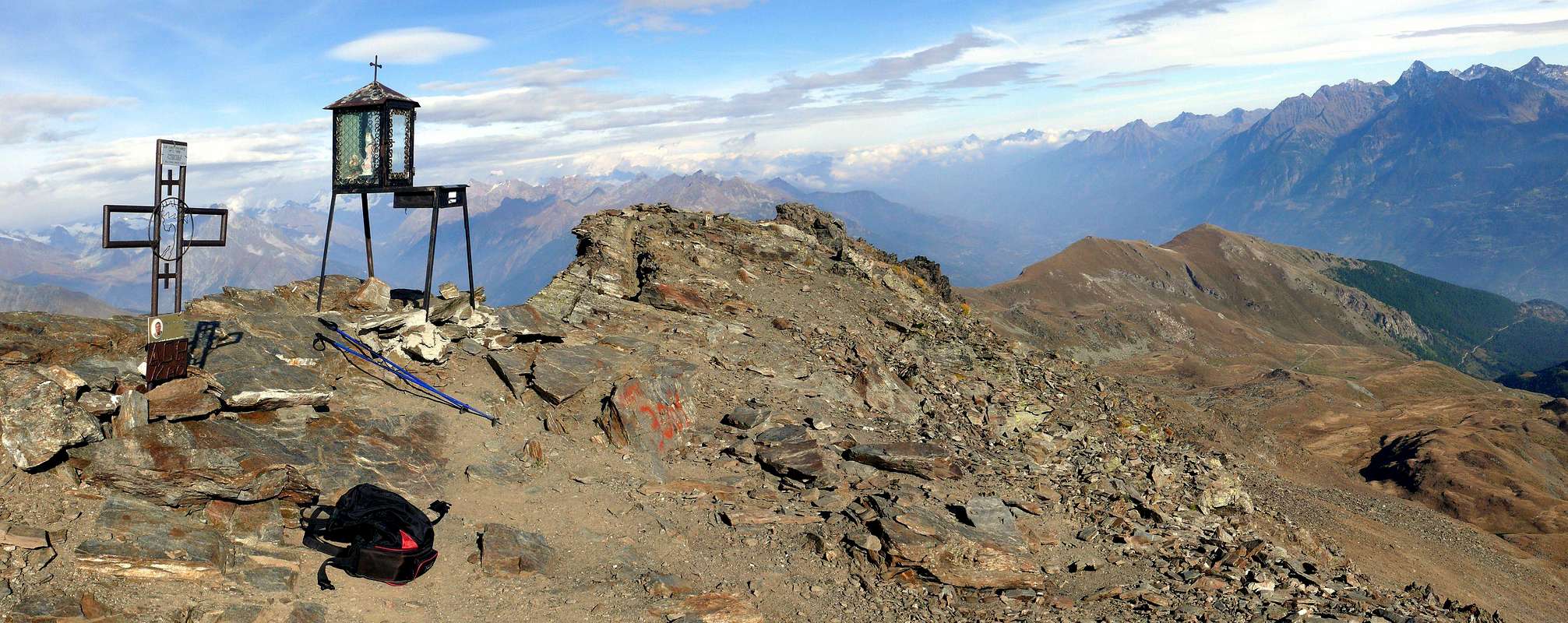
Overview
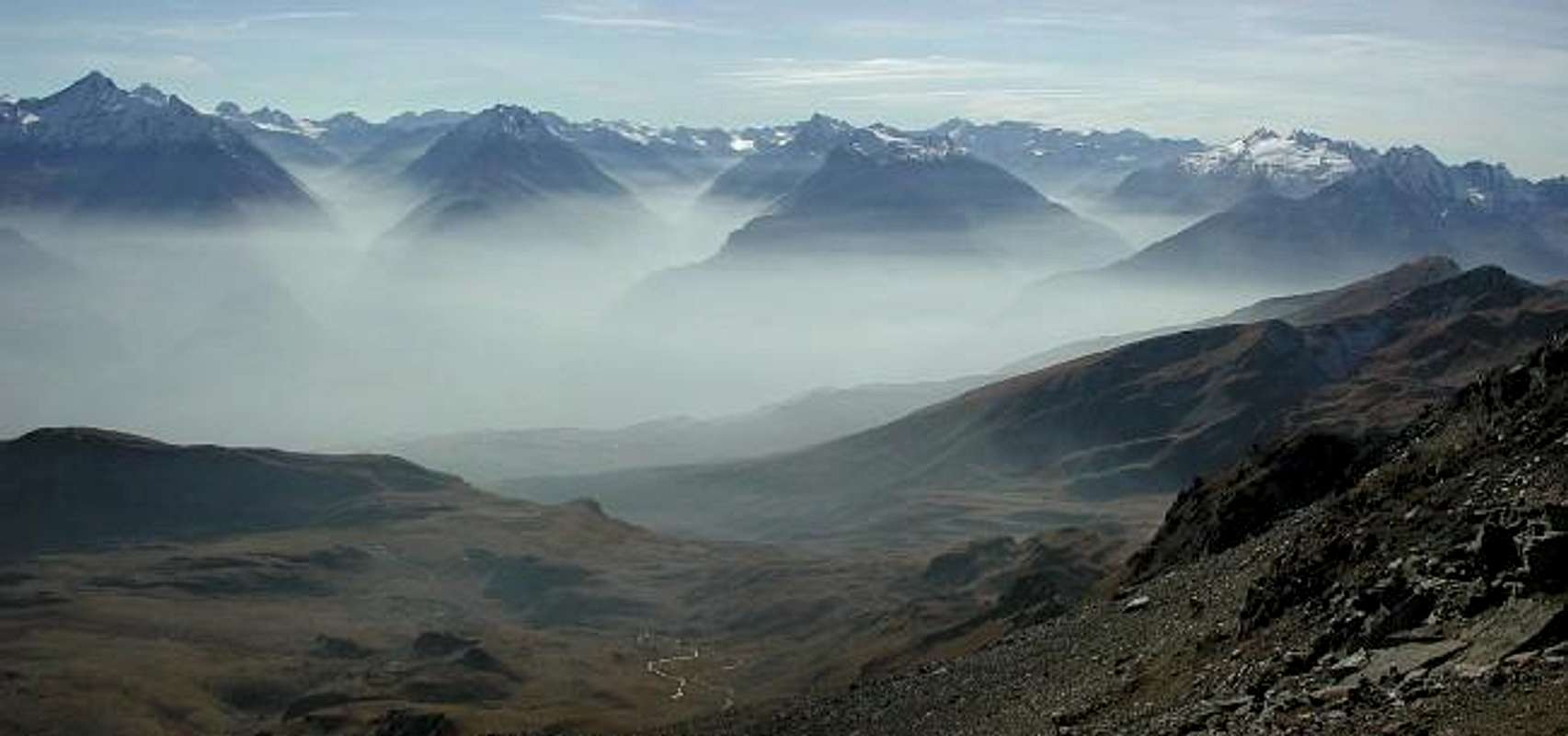
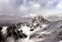
From left: Valsavarenche, Val di Rhemes, Valgrisanche view from the top of Mont Fallère
 |
 |
 |
 |
 |
First Ascents
- On the Summit: Unknown. In winter: Raffaele Armand, Zaccaria Armand, Francesco Chabod and Mario Thomasset, Feb 25th, 1903.
- Second ?: Osvaldo Cardellina and Marco Cossard, Mar 15th, 1973.
- South Slope (Standard Route in East to Shoulder 3.040m and East Crest): Unknown.
- South Slope (Southeast Edge directly from Fallère Lake): Ilario Antonio Garzotto, Dario Franco Cardellina, Osvaldo Cardellina and Walter Ferronato, Aug 01th, 1965, in day.
- South Face (directly by South Rib): Osvaldo Cardellina, Riccardo Botti and Armando Poli, Apr 20th, 1968, in day from Aosta.
- South-southwest Crest: Unknown. West Face: Gino Buscaini and Silvia Metzeltin?, Summer 1970 or 1971?.
- Northwest Ridge (from Fenêtre Pass, Quota 2.971m): Osvaldo Cardellina, lone, Oct 18th, 1992, in ascent and in day from Aosta.
- Northwest Ridge (from Arsy Pass through the Quota 2.971m): Unknown.
- North Slope (to Shoulder 3.043m): Giuseppina Marcoz, Vittorio Marcoz, Yole Mazzetti and Maria Pedrazzini, Aug 03th, 1904, in descent.
- North little Wall (directly to Summit): Osvaldo Cardellina, Marco Cossard and Giuseppe Lamazzi, Sep 10th, 1972, in ascent.
- Northeast Ridge (from pass 2.670m): Unknown.
- Northeast Ridge (traverse from Met Pass, Punta Chaligne, La Tsa, Mont d'Arsy, pass 2.670m): Osvaldo Cardellina and Marco Cossard, Sep 14th, 1974.
- East Face: Unknown or Osvaldo Cardellina, lone, Sep 18th, 1974 in ascent from Thouraz Village and Fallère Lake.
![]()
Getting There
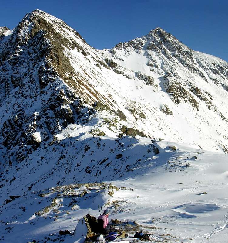
There is more than one possibility to climb this mountain. The easiest one is to drive to Vetan (after St. Nicolas). The deviation from the main road, north side of Aosta, direction Courmayeur, is in St. Pierre. A few meters after the delicious village of Vetan, follow with the car a road direction Loe'. At a certain point the normal traffic is forbidden: park overthere. For the first 40 minutes, walk along the road, straight on till the Alpi Loe', 1.850m, were you can find the water, in case you need. Here there is a panel with the indication: Mont Fallère, 3h'30, number 10. The lane reaches the Alpe Verjoan, 2.100m, close to a small hill with a cross on the top. You can find water also here. Follow the road that brings to the highest Alps, right side, and reach the Fallère lake; after the lake there is the lane that brings you right and left till the east top; a few meters before there are some ruines of a very old refuge. The panorama is wonderful, all around. The 80 meters to reach the West top are not difficult, you cannot simply walk, but you must climb; it'easy, but the valley is more than 100 meters below you.... From the top you can see practically the whole 4.000 of the Aosta Valley. You can come back directly from the top, direction South, for an easy lane; you will find the others lakes, and after the second one, keep your left and join the same lane of the morning.![]()
![]()
![]()
![]()
![]()
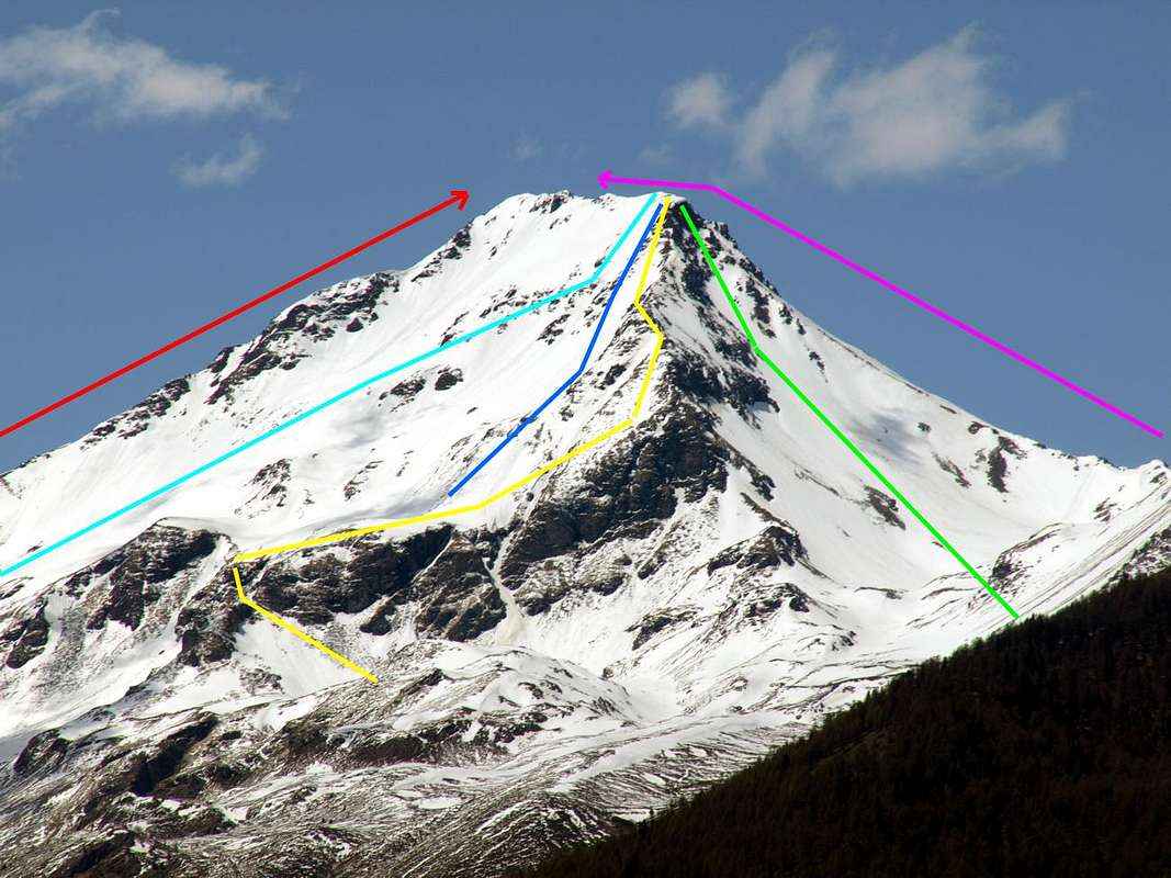
Standard Routes & Approaches
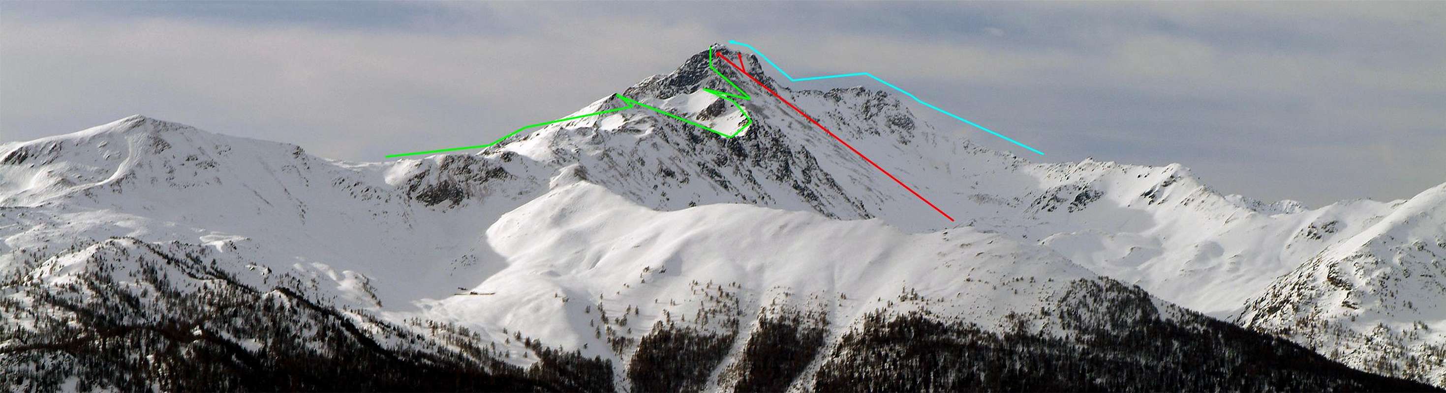
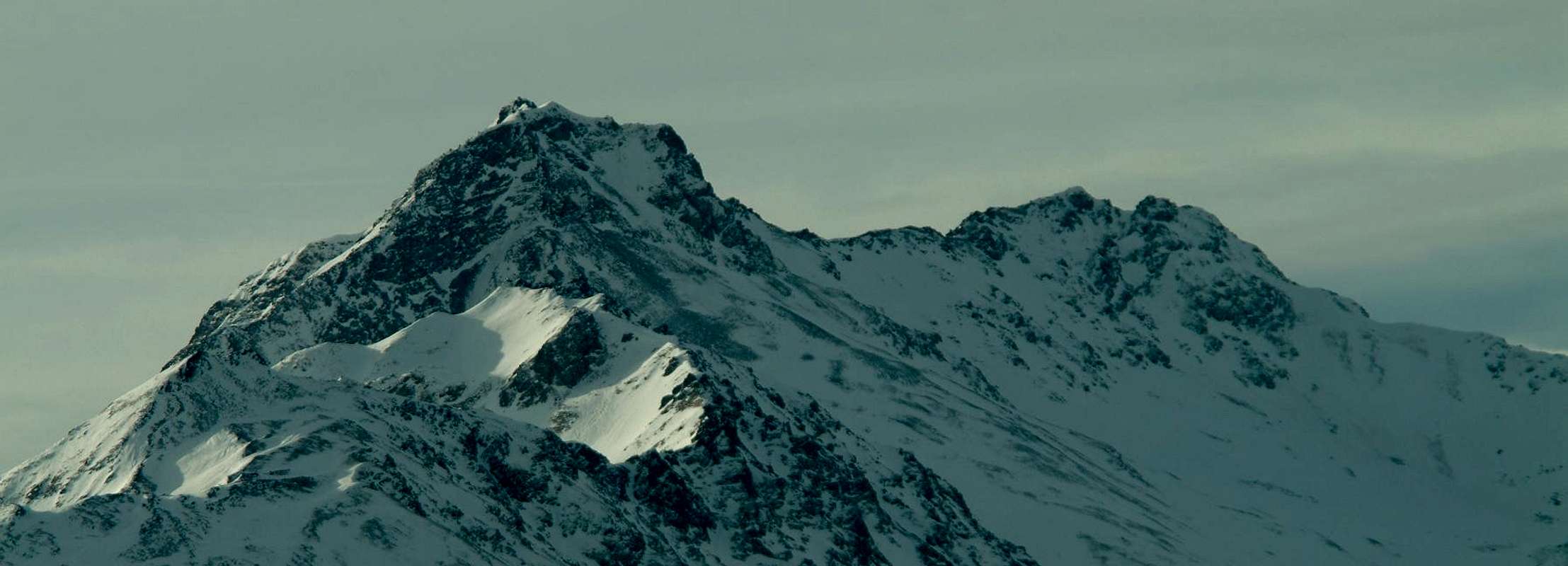
![]() This ancient mountain is a truncated pyramid in the center of the Aosta Valley; formed by three ridges in evidence (Sout-southhwest, Northwest and Northeast) presents atypically four sides, since an edge just mentioned and broken down by steep rocks, covered with grassy slopes, up to Lake Fallère below. The same separates the "classic" South Side, the subject of almost all the climbs this mountain from one side to Eastern, which formed the base from scree slopes, rocky ends with a short hop on the East Summit (3.040/3m), a great big side of flat form. Since this leads to a jagged ridge Western Top, the highest; about the same as a decade have been placed chains gearing up this final stretch of route on which embraces those of the North Face from Arsy Walloon, as well as the long ridge watershed that comes even from Summit of Met, above Aosta Town. The approach to this mountain are numerous and describe them in more detail with the various climbing routes; in any case have to differentiate those from the South with starts from Vetan, Verrogne and Thouraz Villages and also by climbing over the hills of Aosta and crossing Point Chaligne those in the North consisting essentially of Arsy Vallon, above the Etroubles/Saint-Oyen Municipalities into Saint Bernard Valleys.
This ancient mountain is a truncated pyramid in the center of the Aosta Valley; formed by three ridges in evidence (Sout-southhwest, Northwest and Northeast) presents atypically four sides, since an edge just mentioned and broken down by steep rocks, covered with grassy slopes, up to Lake Fallère below. The same separates the "classic" South Side, the subject of almost all the climbs this mountain from one side to Eastern, which formed the base from scree slopes, rocky ends with a short hop on the East Summit (3.040/3m), a great big side of flat form. Since this leads to a jagged ridge Western Top, the highest; about the same as a decade have been placed chains gearing up this final stretch of route on which embraces those of the North Face from Arsy Walloon, as well as the long ridge watershed that comes even from Summit of Met, above Aosta Town. The approach to this mountain are numerous and describe them in more detail with the various climbing routes; in any case have to differentiate those from the South with starts from Vetan, Verrogne and Thouraz Villages and also by climbing over the hills of Aosta and crossing Point Chaligne those in the North consisting essentially of Arsy Vallon, above the Etroubles/Saint-Oyen Municipalities into Saint Bernard Valleys.![Mountain Friends 1963/2013 With Marco Cossard 1965]()
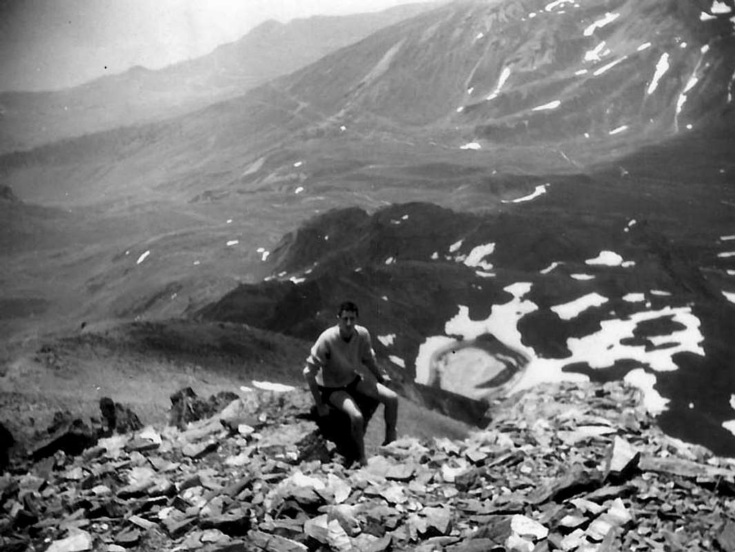
![Fallère Returning from South Slope to Lake Fallère 1965]()
![Mont Fallère Spring Couloir 1968]()
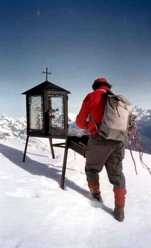
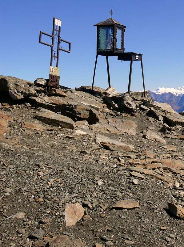
![Mont Fallère Old Tripod Summit s August 1965]()
![Mountain Friends 1963/2013 Fallère with Massimo 1965]()
ANCIENT Approach & OLD Routes to Mont FALLERE Quest'antica montagna é una piramide tronca posta al centro della Val d'Aosta; formata da tre creste in evidenza (Sud-sudovest, Nordovest e Nordest) presenta atipicamente quattro versanti, poiché uno spigolo, appena accennato e spezzato in basso, scende con ripide rocce, ricoperte da infidi pendii erbosi, fino al sottostante Lago Fallère. Lo stesso separa il "classico" Versante Meridionale, oggetto di quasi tutte le salite a questa montagna, da un versante Orientale che, formato alla base da pendii detritici, termina con un corto ma ripido salto roccioso sulla Sommità Est (3.040/43 m), grande spallone di forma quasi piatta. Da questa una cresta frastagliata di 220 m~ conduce alla Cima Ovest, la più elevata; sulla stessa da una decina di anni sono state posizionate delle catene (perealtro non necessarie) attrezzando questo tratto terminale di via sulla quale convergono anche quelle della Faccia Settentrionale dal Vallone di Arsy, nonché la lunga cresta spartiacque proveniente addirittura dalla Punta di Met, sopra la Città di Aosta. Gli avvicinamenti a questa montagna sono molteplici e li descriveremo con le varie vie di salita; in ogni caso son da differenziare quelli che provengono da Sud con partenze dai Villaggi di Vetan, Verrogne, Thouraz ed anche dalla collina di Aosta scavalcando le Punte Chaligne da quelli a Settentrione consistenti essenzialmente dal Vallone dell'Arsy, sopra i Comuni di Etroubles e Saint-Oyen nella Valle del Gran San Bernardo.![]()
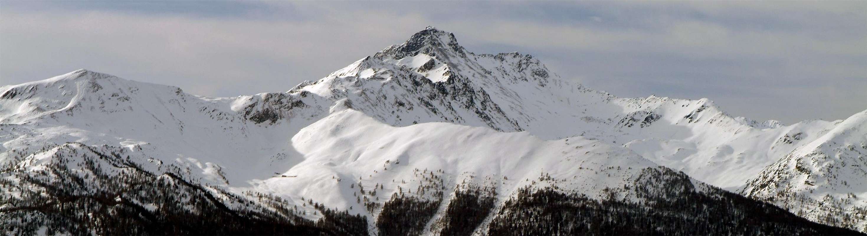
The old Southern Slope by Margherita Queen Shelter
![]() Surely the Normal Route to this mountain that must be considered along the large South Slope. But many variations lead to the peak, especially in approaches that may occur from the Southwest, or from the Tourist Center Vetan (1.671m) through the Vallon of Verrogne first and then entering one of Clusella through a small saddle (2.255m) at the base its Southwest Ridge. The same can be achieved more directly starting from the Village of Verrogne (1.582m) and going up the vallon of the same name, but also from the Vallon of Clusella starting at the new little village of Thouraz (+; 1.652m) above Ville sur Sarre (1.212m). Typically this is mostly used to climb the Southwest Crest, and from Vetan is a necessary step, going up the vallon to the West is discarded Clusella happening climb directly through the South Side of the base of the mountain that extends Eastward from the aforementioned saddle until it reaches a slightly accentuated and Southeast Edge so as to separate this from the North Slope. The basis of, in a small grassy-rocky bifurcation, there is the bautiful Lake Fallère (2.415m), from which a small path goes back to the rocky promontory above and then go to connect with the muletrack-path (renewed for a little over a decade) that reaches the old Hutte Regina Margherita (2.983m), built in 1884 and is now completely destroyed. This main path goes more to the West and begins between the small Loch Clapin and Chaz de Morgnoz (2.271m); first goes directly to the North then, bending gradually to the East with many bends, reaches remains the same. A slope of rocks and debris easy reach in a short time the West Shoulder (3.043m); this crossing on the Eastern Edge of about 220 meters leads to Summit. This trait was not long equipped with chains, which exceed a few short sections with challenging rock gear; this crossing is easy but in some short places it is exposed (E/F/F+; 1h'30/1h'40 from lake 2.415m).
Surely the Normal Route to this mountain that must be considered along the large South Slope. But many variations lead to the peak, especially in approaches that may occur from the Southwest, or from the Tourist Center Vetan (1.671m) through the Vallon of Verrogne first and then entering one of Clusella through a small saddle (2.255m) at the base its Southwest Ridge. The same can be achieved more directly starting from the Village of Verrogne (1.582m) and going up the vallon of the same name, but also from the Vallon of Clusella starting at the new little village of Thouraz (+; 1.652m) above Ville sur Sarre (1.212m). Typically this is mostly used to climb the Southwest Crest, and from Vetan is a necessary step, going up the vallon to the West is discarded Clusella happening climb directly through the South Side of the base of the mountain that extends Eastward from the aforementioned saddle until it reaches a slightly accentuated and Southeast Edge so as to separate this from the North Slope. The basis of, in a small grassy-rocky bifurcation, there is the bautiful Lake Fallère (2.415m), from which a small path goes back to the rocky promontory above and then go to connect with the muletrack-path (renewed for a little over a decade) that reaches the old Hutte Regina Margherita (2.983m), built in 1884 and is now completely destroyed. This main path goes more to the West and begins between the small Loch Clapin and Chaz de Morgnoz (2.271m); first goes directly to the North then, bending gradually to the East with many bends, reaches remains the same. A slope of rocks and debris easy reach in a short time the West Shoulder (3.043m); this crossing on the Eastern Edge of about 220 meters leads to Summit. This trait was not long equipped with chains, which exceed a few short sections with challenging rock gear; this crossing is easy but in some short places it is exposed (E/F/F+; 1h'30/1h'40 from lake 2.415m).![]() Sicuramente la Via Normale a questa montagna deve esser considerata quella lungo il Versante Meridionale. Ma molte varianti conducono alla Cima, soprattutto negli avvicinamenti che posson avvenire da Sudovest, ovvero dal Centro Turistico di Vetan (1.671 m) attraversando dapprima il Vallone di Verrogne e poi entrando in quello di Clusella tramite una piccola sella (2.255 m) posta alla base della sua Cresta Sudovest; la stessa può essere più direttamente raggiunta partendo dal Villaggio di Verrogne (1.582 m) e risalendo l'omonimo vallone, ma pure dal Vallone di Clusella con partenza dal nuovo villaggio di Thouraz (+; 1.652 m), sopra Ville sur Sarre (1.212 m). In genere questa viene maggiormente utilizzata per salire la Cresta Sudovest e, mentre da Vetan costituisce un passaggio obbligato, salendo la Valle Clusella viene scartata ad Occidente avvenendo la salita direttamente tramite il Versante Sud. Alla base della montagna questo si allarga dalla predetta sella verso Oriente fino a raggiungere uno Spigolo Sudest poco accentuato e tale da separare questo dal Versante Est; alla base del medesimo, in una piccola biforcazione erboso-rocciosa, è situato il Lago Fallère (2.415 m), dal quale un sentierino risale al soprastante promontorio roccioso per andar poi a collegarsi con la mulattiera-sentiero (rinnovata da poco più d'un decennio) che raggiunge la vecchia Capanna Regina Margherita (2.983 m) costruita nel 1884 ed ormai completamente andata distrutta. Questo sentiero principale sale più ad Occidente ed inizia tra il minuscolo Lago Clapin e la Chaz de Morgnoz (2.271 m); dapprima risale direttamente verso Settentrione poi, piegando gradualmente ad Est con molti tornanti, raggiunge i resti della medesima. Un pendio di roccette e detriti raggiunge in breve la Spalla Est (3.043 m); da questa una traversata sulla Cresta Est di 220 m~ conduce alla Cima. Questo tratto é stato da non molto tempo attrezzato con catene, che superano qualche tratto impegnativo con roccia marcia; questa traversata é facile ma in alcuni brevi punti risulta esposta (E/F/F+; 1h'30/1h'40 dal lago 2.415 m).
Sicuramente la Via Normale a questa montagna deve esser considerata quella lungo il Versante Meridionale. Ma molte varianti conducono alla Cima, soprattutto negli avvicinamenti che posson avvenire da Sudovest, ovvero dal Centro Turistico di Vetan (1.671 m) attraversando dapprima il Vallone di Verrogne e poi entrando in quello di Clusella tramite una piccola sella (2.255 m) posta alla base della sua Cresta Sudovest; la stessa può essere più direttamente raggiunta partendo dal Villaggio di Verrogne (1.582 m) e risalendo l'omonimo vallone, ma pure dal Vallone di Clusella con partenza dal nuovo villaggio di Thouraz (+; 1.652 m), sopra Ville sur Sarre (1.212 m). In genere questa viene maggiormente utilizzata per salire la Cresta Sudovest e, mentre da Vetan costituisce un passaggio obbligato, salendo la Valle Clusella viene scartata ad Occidente avvenendo la salita direttamente tramite il Versante Sud. Alla base della montagna questo si allarga dalla predetta sella verso Oriente fino a raggiungere uno Spigolo Sudest poco accentuato e tale da separare questo dal Versante Est; alla base del medesimo, in una piccola biforcazione erboso-rocciosa, è situato il Lago Fallère (2.415 m), dal quale un sentierino risale al soprastante promontorio roccioso per andar poi a collegarsi con la mulattiera-sentiero (rinnovata da poco più d'un decennio) che raggiunge la vecchia Capanna Regina Margherita (2.983 m) costruita nel 1884 ed ormai completamente andata distrutta. Questo sentiero principale sale più ad Occidente ed inizia tra il minuscolo Lago Clapin e la Chaz de Morgnoz (2.271 m); dapprima risale direttamente verso Settentrione poi, piegando gradualmente ad Est con molti tornanti, raggiunge i resti della medesima. Un pendio di roccette e detriti raggiunge in breve la Spalla Est (3.043 m); da questa una traversata sulla Cresta Est di 220 m~ conduce alla Cima. Questo tratto é stato da non molto tempo attrezzato con catene, che superano qualche tratto impegnativo con roccia marcia; questa traversata é facile ma in alcuni brevi punti risulta esposta (E/F/F+; 1h'30/1h'40 dal lago 2.415 m).![]()
The equipped South-southwest Crest & West Face from Lago Morto
A) - this ridge, orographic speaking, even takes origin from Becca France (+; 2.312m) above the Municipalities of Sarre and Saint Pierre and salt separating the Vallons of Clusella East and Verrogne on the opposite side. This route can be started from the new Village Thouraz or Thora (1.593m; cartel prohibition of transit immediately after the private dirt farm road at an altitude of 1.638m) in the first vallon or from that of Verrogne (+; 1.595m) and the homonymous by Vetan Dessus (Upper; 1.770m) through the Alps Grandzettaz, Grandes Arpilles (2.252m) and Les Crottes (2.385m), last alpage. All of these approaches lead, by means of roadways followed by paths, the small saddle (2.251m), placed at the base of the ridge. It is preferable to approach starting from the Vetan, because more "direct". After the South Slope is certainly the most traveled, so much so that some passages of "critical" were placed chains, now thirty years old. The same takes practice starting from the small saddle 2.251 meters, located between the two lakes Clapin (2.517m) to the East and delle Rane or des Grenouilles (Frogs; 2.363m) to the West; grassy-rocky promontory after a 2.569 meters, climb directly in its middle by a grassy-rocky slope between two small walls or rock wanders through the debris couloirs to the North of her hips, the ridge changes direction from South-southeast to South-southwest. In general, the same is achieved by using a Est grassy-debris small gully on the Eastern side just after the cape, but it is also possible to reach even higher up towards the 2.630/40 meters, which rises in a linear fashion until you reach a second promontory of rotten rocks on which were placed the chains with a left-right (beautiful views to below Morto Loch (Dead; 2.634m); passed the same (2.893m), the ridge returns to be linear and leads to the terminal part, where a series of "penitentes" allows easy and amusing climbing. Usually they are around the left or to the right or passing in their midst, but can be useful in case of snow; latest crushed rocks and a small dirt track on soil easily lead to Summit (+; EE/F+/PD-; 1h'45/2h'00 from the small saddle 2.251m). It is also possible to make this path downhill, bearing in mind that in the presence of fresh snow it must be approached with some caution; in fact the same, resting on steep grassy slopes, tend to create hazardous situations of detachment or slipping.![]()
![Mont Fallere]()
![Il mont Fallère (3061 m.)...]()
![Il versante sud del Mont Fallère (3061 m)]()
![Mont Fallere]()
![Il versante sud del mont...]() A) - questa cresta che, orograficamente parlando, prende addirittura origine dalla Becca France (2.312 m) sopra i Comuni di Sarre e Saint Pierre risale separando i Valloni di Clusella ad Oriente e Verrogne nella parte opposta. Questa via può iniziare sia dal nuovo Villaggio di Thouraz o Thora (1.593 m; cartello di divieto del transito subito dopo sulla strada poderale a quota 1638 m) nel primo vallone oppure da quello di Verrogne (+; 1.595 m) nell'omonimo ed inoltre da Vetan Dessus (1.770 m) tramite gli Alpeggi di Granzettaz, Grandes Arpilles (2.252 m) e Les Crottes (2.385 m). Tutti questi avvicinamenti conducono, per mezzo di strade poderali seguite da sentieri, alla selletta (2.251 m), posta alla base. Risulta preferibile l'avvicinamento con partenza dal Villaggio di Vetan, poiché certamente più "diretto". Dopo il Versante Sud risulta sicuramente la più percorsa, tanto che su alcuni passaggi "cruciali" sono state collocate delle catene, ormai da una trentina di anni. La medesima prende in pratica inizio dalla selletta 2.251 metri, posizionata tra i due Laghetti Clapin (2.517 m) ad Est e delle Rane o des Grenouilles (2.363 m) ad Ovest; dopo un promontorio erboso-roccioso 2.569 m, che si risale direttamente nel suo mezzo tramite un pendio erboso-roccioso tra due paretine rocciose o s'aggira tramite i canali a Nord dei suoi fianchi, la cresta cambia direzione da Sud-sudest a Sud-sudovest. Generalmente la stessa viene raggiunta da Est tramite un canalino erboso-detritico sul lato Orientale subito dopo il promontorio, ma é inoltre possibile toccarla anche più in alto fino verso i 2.630/40 m, ove risale in modo lineare fino ad incontrare un secondo promontorio di rocce rotte sulle quali sono state posizionate delle catene con andamento da sinistra a destra (belle viste sul sottostante Lago Morto 2.634 m); superato lo stesso (2.893 m), la cresta ritorna ad esser nuovamente lineare e conduce alla parte terminale, dove una serie di "penitentes" consente una facile e divertente arrampicata. Solitamente li s'aggira sulla sinistra o in destra oppure passandovi proprio in mezzo, ma posson diventare utili nel caso di neve alta; ultime roccette frantumate ed una piccola traccia sul terriccio adducono facilmente proprio in Cima (+; EE/F+/PD-; 1h'45/2h'00 dalla selletta 2.251 m). Risulta possibile effettuare questo percorso anche in discesa, tenendo però presente che in caso di presenza di neve fresca lo stesso deve essere affrontato con una certa cautela; in effetti i medesimi, appoggiando su ripidi pendii erbosi, tendono a creare pericolose situazioni di distacco o di scivolamento.
A) - questa cresta che, orograficamente parlando, prende addirittura origine dalla Becca France (2.312 m) sopra i Comuni di Sarre e Saint Pierre risale separando i Valloni di Clusella ad Oriente e Verrogne nella parte opposta. Questa via può iniziare sia dal nuovo Villaggio di Thouraz o Thora (1.593 m; cartello di divieto del transito subito dopo sulla strada poderale a quota 1638 m) nel primo vallone oppure da quello di Verrogne (+; 1.595 m) nell'omonimo ed inoltre da Vetan Dessus (1.770 m) tramite gli Alpeggi di Granzettaz, Grandes Arpilles (2.252 m) e Les Crottes (2.385 m). Tutti questi avvicinamenti conducono, per mezzo di strade poderali seguite da sentieri, alla selletta (2.251 m), posta alla base. Risulta preferibile l'avvicinamento con partenza dal Villaggio di Vetan, poiché certamente più "diretto". Dopo il Versante Sud risulta sicuramente la più percorsa, tanto che su alcuni passaggi "cruciali" sono state collocate delle catene, ormai da una trentina di anni. La medesima prende in pratica inizio dalla selletta 2.251 metri, posizionata tra i due Laghetti Clapin (2.517 m) ad Est e delle Rane o des Grenouilles (2.363 m) ad Ovest; dopo un promontorio erboso-roccioso 2.569 m, che si risale direttamente nel suo mezzo tramite un pendio erboso-roccioso tra due paretine rocciose o s'aggira tramite i canali a Nord dei suoi fianchi, la cresta cambia direzione da Sud-sudest a Sud-sudovest. Generalmente la stessa viene raggiunta da Est tramite un canalino erboso-detritico sul lato Orientale subito dopo il promontorio, ma é inoltre possibile toccarla anche più in alto fino verso i 2.630/40 m, ove risale in modo lineare fino ad incontrare un secondo promontorio di rocce rotte sulle quali sono state posizionate delle catene con andamento da sinistra a destra (belle viste sul sottostante Lago Morto 2.634 m); superato lo stesso (2.893 m), la cresta ritorna ad esser nuovamente lineare e conduce alla parte terminale, dove una serie di "penitentes" consente una facile e divertente arrampicata. Solitamente li s'aggira sulla sinistra o in destra oppure passandovi proprio in mezzo, ma posson diventare utili nel caso di neve alta; ultime roccette frantumate ed una piccola traccia sul terriccio adducono facilmente proprio in Cima (+; EE/F+/PD-; 1h'45/2h'00 dalla selletta 2.251 m). Risulta possibile effettuare questo percorso anche in discesa, tenendo però presente che in caso di presenza di neve fresca lo stesso deve essere affrontato con una certa cautela; in effetti i medesimi, appoggiando su ripidi pendii erbosi, tendono a creare pericolose situazioni di distacco o di scivolamento.![]()
![]()
Northwestern Ridge on great Shoulder from Fenêtre Pass
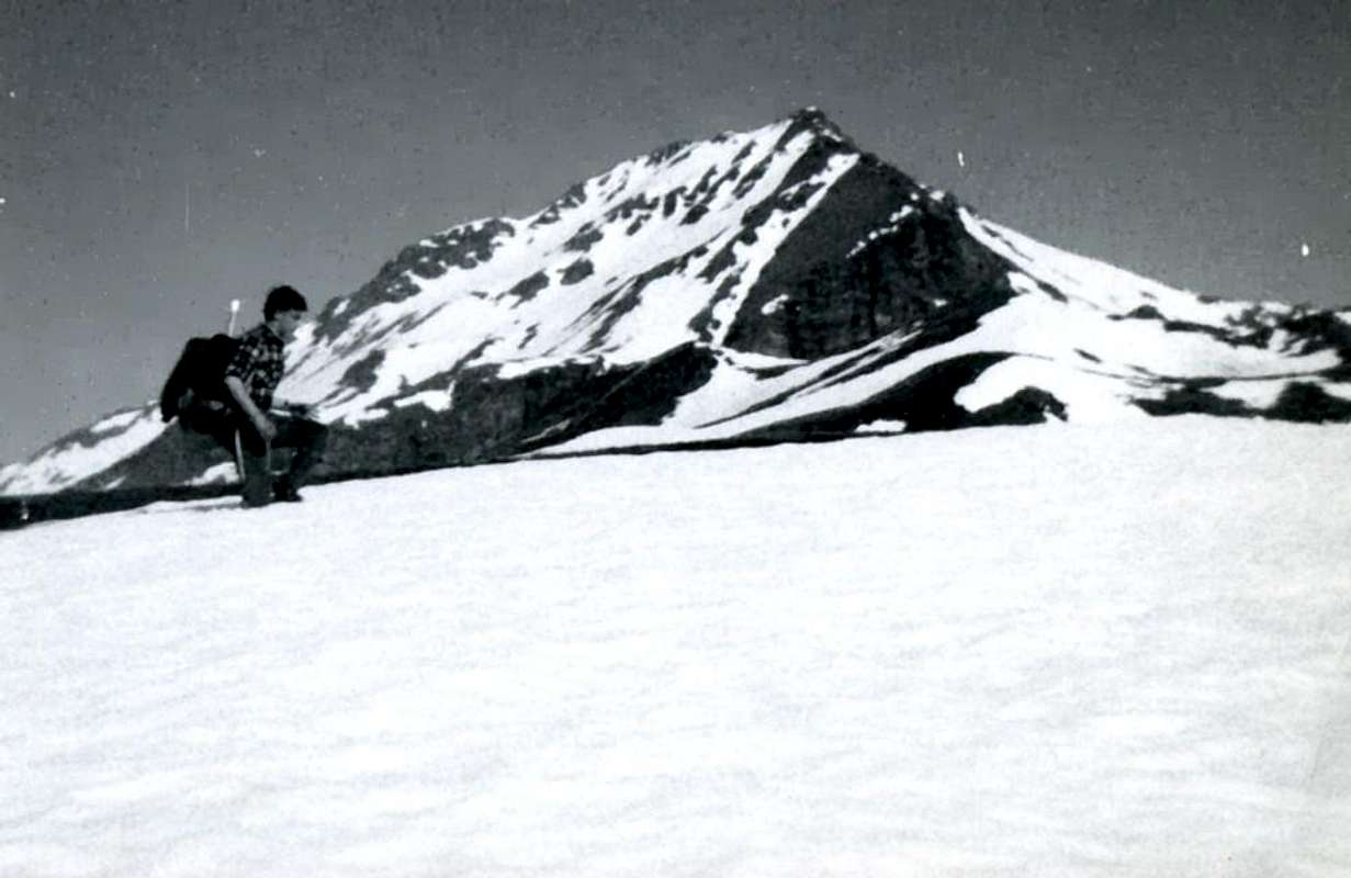
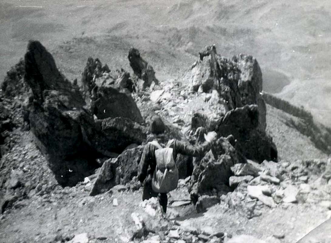
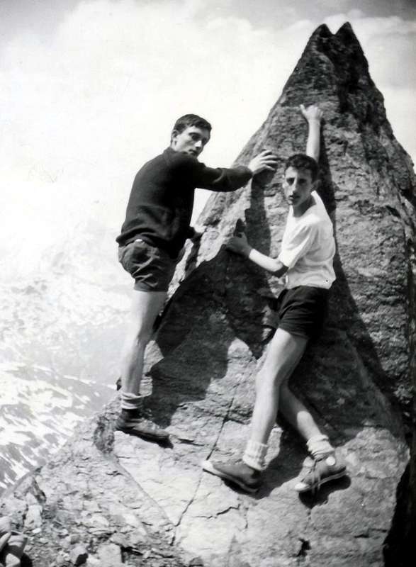
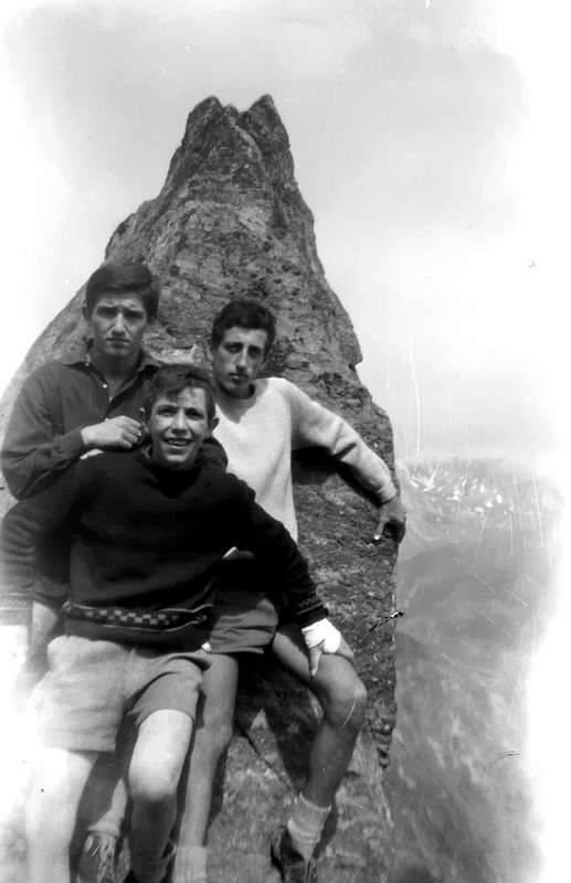
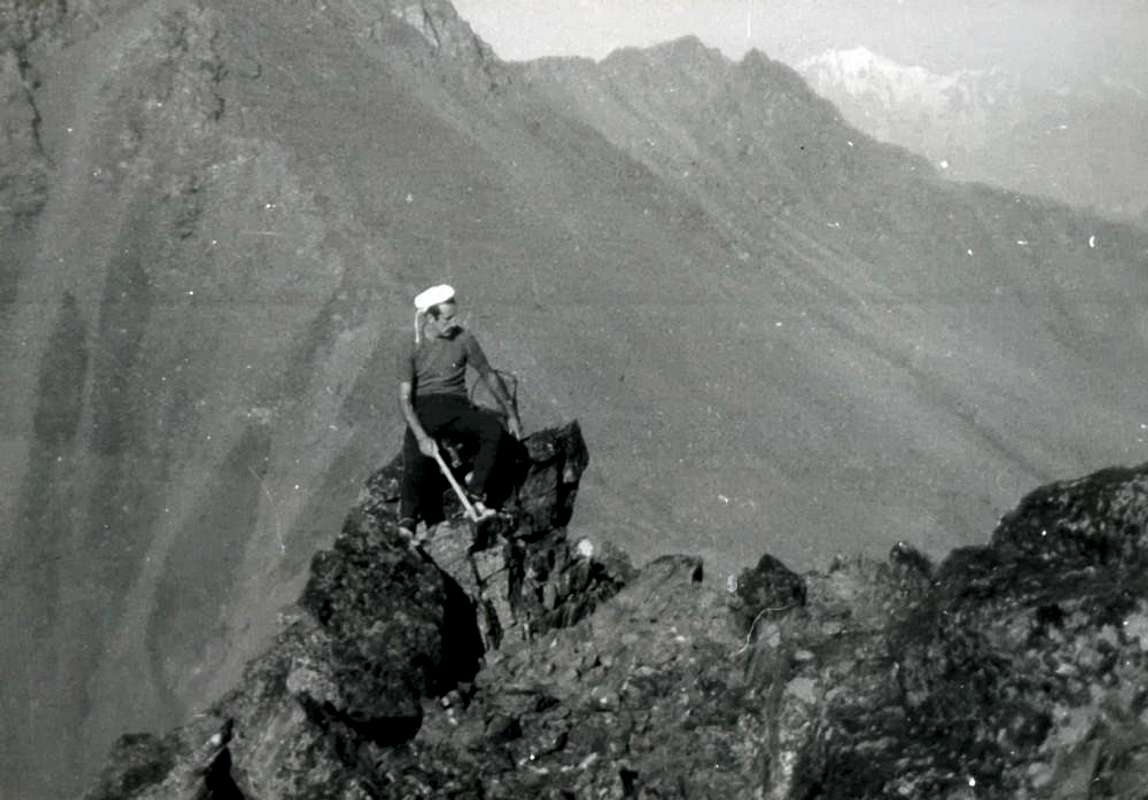
![]() This long ridge has the characteristic of doubling in two distinct branches: going down from the Top with a big shoulder trend Northwest reaches almost horizontal (2.971/3m); from this ramification descends more rugged, completely changing the direction West-southwest, towards the Fenêtre Pass (2.729m) at the end of the long vallon that rises from the Village of Vétan. A second branch instead declines to the North-northeast, reaching first a minor altitude (2.707m), just above the three Lakes of Ars or Arsy (2520m, 2.479m), and then the eponymous pass (2.534m); after being raised to the Mount Labiez (2.632m; Bivouac of Forestry, private and always closed), the partition goes down again towards the North, reaching the Grande Tête (2.455m) to finally conclude on the Bois (Wood) de Lanche in the Municipality of Saint Oyen. Surely the most popular is this last, especially after the construction of the camp, while with regard to the first, shorter but more challenging, there is no news to go up at least until 1971, the year of writing "Pennine Alps Vol I°", by Gino Buscaini. The same is clear, using the conditional, that the author is not aware of it: "It could offer a nice level trail ... if you are missing details, but it is assumed that the difficulties will bypass the second degree". From a personal climb, you confirm everything pointing out that the most challenging part lies in the stretch from the hill reaches the great shoulder, because the rocks are also somewhat routes covered by grass "Olline", very slippery and dangerous. Reached the same (not recommended workarounds in the South for the above reason), continue along the ridge nearly horizontal to finally conclude in the end, even where it exits the gully of the Western Face, through rotten and broken rocks with debris, but very easy (even here we must not abandon the edge of the ridge), going at a fine tooth rocky fun climb (you can not reach standing up, see the two old photos in B&W above and below), just before the true Summit (3.059/61m; EE/A; from PD to PD+, depending on the passages dealt with. 1h'30/1h'45).
This long ridge has the characteristic of doubling in two distinct branches: going down from the Top with a big shoulder trend Northwest reaches almost horizontal (2.971/3m); from this ramification descends more rugged, completely changing the direction West-southwest, towards the Fenêtre Pass (2.729m) at the end of the long vallon that rises from the Village of Vétan. A second branch instead declines to the North-northeast, reaching first a minor altitude (2.707m), just above the three Lakes of Ars or Arsy (2520m, 2.479m), and then the eponymous pass (2.534m); after being raised to the Mount Labiez (2.632m; Bivouac of Forestry, private and always closed), the partition goes down again towards the North, reaching the Grande Tête (2.455m) to finally conclude on the Bois (Wood) de Lanche in the Municipality of Saint Oyen. Surely the most popular is this last, especially after the construction of the camp, while with regard to the first, shorter but more challenging, there is no news to go up at least until 1971, the year of writing "Pennine Alps Vol I°", by Gino Buscaini. The same is clear, using the conditional, that the author is not aware of it: "It could offer a nice level trail ... if you are missing details, but it is assumed that the difficulties will bypass the second degree". From a personal climb, you confirm everything pointing out that the most challenging part lies in the stretch from the hill reaches the great shoulder, because the rocks are also somewhat routes covered by grass "Olline", very slippery and dangerous. Reached the same (not recommended workarounds in the South for the above reason), continue along the ridge nearly horizontal to finally conclude in the end, even where it exits the gully of the Western Face, through rotten and broken rocks with debris, but very easy (even here we must not abandon the edge of the ridge), going at a fine tooth rocky fun climb (you can not reach standing up, see the two old photos in B&W above and below), just before the true Summit (3.059/61m; EE/A; from PD to PD+, depending on the passages dealt with. 1h'30/1h'45).![Mont Fallère]()
![Mount Fallère from West View, by Crevassino 1972]()
![Da sinistra: la punta...]()
![Gran Paradiso range from Col Finestra, near Mont Fallere]()
![Mont Fallère]() Questa lunga cresta presenta la caratteristica di sdoppiarsi in due ramificazioni ben distinte: scendendo dalla Cima con andamento Nordovest raggiunge uno spallone quasi orizzontale (2.973 m); da questa un ramo più accidentato discende, cambiando completamente direzione in Ovest-sudovest, verso il Col Fenêtre (2.729 m) al termine del lungo vallone risalente dal Villaggio di Vétan. Un secondo declina invece a Nord-nordest raggiungendo dapprima una quota secondaria (2.707 m), subito al di sopra dei tre Laghi d'Ars (2.520 m, 2.479 m), e quindi l'omonimo passo (2.534 m); dopo essersi rialzato al Mont Labiez (2.632 m; Bivacco della Forestale, privato e chiuso), il divisorio scende ancora verso Settentrione raggiungendo la Grande Tête (2.455 m) per infine esaurirsi sopra il Bois de Lanche nel Comune di Saint Oyen. Sicuramente la parte più frequentata risulta quest'ultima, soprattutto dopo la costruzione del bivacco, mentre per quanto concerne la prima, più breve ma maggiormente impegnativa, non s'hanno notizie di salite almeno fino al 1971, anno di stesura di "Alpi Pennine Vol. I°", ad opera di Gino Buscaini. Nella medesima appare chiaramente, usando il condizionale, che l'autore non ne é a conoscenza: "Potrebbe offrire un bel percorso in cresta se... Mancano particolari, ma si presume che le difficoltà si aggirino sul II° grado". Da una salita personale, si conferma il tutto, evidenziando come la parte più impegnativa si collochi nel tratto che dal colle raggiunge la spalla, anche perché le rocce alquanto rotte sono inoltre ricoperte da erba "ollina", molto scivolosa e pericolosa. Raggiunta la medesima (sconsigliabili gli aggiramenti a Sud per il motivo suddetto), proseguire lungo il filo di cresta quasi orizzontale per infine concludere nella parte finale, ove esce anche il canalino della Parete Ovest, tramite rocce molto rotte con detrito, ma facili, passando presso un bel dente roccioso di divertente salita (non si può raggiungerlo restando in piedi, vedi le due vecchie foto in B&W appresso), subito prima della Sommità (3.059/61 m; EE/A/da PD a PD+, a seconda dei passaggi affrontati. 1h'30/1h'45).
Questa lunga cresta presenta la caratteristica di sdoppiarsi in due ramificazioni ben distinte: scendendo dalla Cima con andamento Nordovest raggiunge uno spallone quasi orizzontale (2.973 m); da questa un ramo più accidentato discende, cambiando completamente direzione in Ovest-sudovest, verso il Col Fenêtre (2.729 m) al termine del lungo vallone risalente dal Villaggio di Vétan. Un secondo declina invece a Nord-nordest raggiungendo dapprima una quota secondaria (2.707 m), subito al di sopra dei tre Laghi d'Ars (2.520 m, 2.479 m), e quindi l'omonimo passo (2.534 m); dopo essersi rialzato al Mont Labiez (2.632 m; Bivacco della Forestale, privato e chiuso), il divisorio scende ancora verso Settentrione raggiungendo la Grande Tête (2.455 m) per infine esaurirsi sopra il Bois de Lanche nel Comune di Saint Oyen. Sicuramente la parte più frequentata risulta quest'ultima, soprattutto dopo la costruzione del bivacco, mentre per quanto concerne la prima, più breve ma maggiormente impegnativa, non s'hanno notizie di salite almeno fino al 1971, anno di stesura di "Alpi Pennine Vol. I°", ad opera di Gino Buscaini. Nella medesima appare chiaramente, usando il condizionale, che l'autore non ne é a conoscenza: "Potrebbe offrire un bel percorso in cresta se... Mancano particolari, ma si presume che le difficoltà si aggirino sul II° grado". Da una salita personale, si conferma il tutto, evidenziando come la parte più impegnativa si collochi nel tratto che dal colle raggiunge la spalla, anche perché le rocce alquanto rotte sono inoltre ricoperte da erba "ollina", molto scivolosa e pericolosa. Raggiunta la medesima (sconsigliabili gli aggiramenti a Sud per il motivo suddetto), proseguire lungo il filo di cresta quasi orizzontale per infine concludere nella parte finale, ove esce anche il canalino della Parete Ovest, tramite rocce molto rotte con detrito, ma facili, passando presso un bel dente roccioso di divertente salita (non si può raggiungerlo restando in piedi, vedi le due vecchie foto in B&W appresso), subito prima della Sommità (3.059/61 m; EE/A/da PD a PD+, a seconda dei passaggi affrontati. 1h'30/1h'45).![]()
Northern Face to Great Saint Bernard Valley in Arsy Vallon
![]()
APPROACHES To achieve this you must pass mandatory side of the Great Saint Bernard Valley with three different possibilities of approach, starting from the lower-middle part by the State Road n°27, leading into the Ars also Arsy Vallon, or by Condemine, Echevennoz Hamlet or Etroubles Municipality. 1) - from Gignod Commune (988m) reach the road alternative Municipal and turn left go to the place called Condemine (1.137m); after having surpassed, continue to Villages of Grand and Petit Buthier (1.302m, 1.439m, fountain) at the entrance of Comba Chaligne; leaving to the left (South) the short detour to Clemencey (1.409m), we carry on instead at first westward reaching Mendey (1.547m) and then, more in the Southwest, in the direction of the Pastures of Roncaille, Rombason (1.656m, 1.695m) reaching 1.723 meters at the junction for Arolla Dèsott and the next for Damon. Discard both always reaching to the left, at a bend at an acute angle, the subsequent diversion; abandoned this road that continues to the South, reaching the new Refuge Chaligne (1.936m), continue to the right (Northwest) through another private dirt farms road that reaches the pasture block Collet (1.919m). The same, doubling the Tardiva Costa or Crest (2.380m), goes through a long diagonal towards the Southwest and alongside the Ru (Brook for irrigation) Collet progressively introduced in the Walloon of Arsy; crossed the eponymous Torrent reach Alp d'Ars (1.975m) and the Tsa d'Ars (2.263m), or so-called upper and last pasture (E; 1h'45/2h'00 from the winding road just before Mendey Village).2) - from Echevennoz Fraction (1.233-1.264m; "Ei qui ven à nos" or is water that is in us, by the course of the stream that comes from above Ars Vallon; Hostel Marietty), reached by a short detour from the main road, and starting from Dessus via a short private road, or more to the right (West) with the path to arrive at a small village (1.408m, up to here with the private road which, passing high above Echevennoz from Northwest to Southeast, connects the Villages above Lavanche (around 1.300m) to this Gariache (1.472m)). From this, with the path to the South and through the forest to reach Eteley (1.716m), and the next route that comes from Etroubles, this via, in our opinion, certainly is the most recommended among the three described as more practical and the most direct (E; 2h'00/2h'15).3) - from Etroubles Municipality (1.270m) via the path concomitant with the private road until the junction about 1.400 meters immediately after the village neighbor Alp Lavanche and before Champ-Reclos (1.425m); left on the left (Southeast) a secondary deviation, it continues in the opposite direction on the main road to gradually reach the Pastures of Yettes (1.591m), and through the Bois (Wood) de Peson and discarding the right to further branching Teppes (1.879m), those successive Eteley. Continuing towards the walloon floor and crossing the Torrent d'Ars, you reach a junction immediately before the Alp Praz-Gallet (1.626m), which is to the left; this finally with a long diagonal to the South-southeast into forest to reach the Ars Alpage, whence the preceding route (E; 2h'15/2h'30).ROUTE The North Slope is split into two sides: one is farther North-northeast between the East-Northeast Crest (see itinerary below) and a large pillar of broken rocks turned decidedly to the North; this debris over a wide side-rocky stretches from the left (East) to the right towards the large Shoulder (2.971/3m) of the Northwest Ridge in its most Northern branch, which descends to the Col d'Ars (2.543m) among the namesake walloon and the side Flassin. While the former is totally inadvisable, if not with the exceptions suggested in the following itinerary, as regards the second is to note how the same constitutes the "Normal Route" coming from the Low/Middle Valley of the Great St. Bernard; nevertheless it is really poorly attended, although the construction of the Bivouac of the Forest in recent years may have increased the number of visits, at least, being private and closed by the Guards themselves. Maybe in the distant past, when there were no South Slope on the current private dirt farms roads that facilitate the approaches, it was more because the slopes were almost identical to go so that route also appears to have been down in 1904; in practice today is almost completely fallen into disuse for the fact that the almost total absence of snowfields (up to forty years ago there until late in the season) makes the climb somewhat boring and completely devoid of a trail. In turn, however, this face is divided into two distinct sectors: a usually with some debris falling rocks in the terminal directed more to the East, which culminates on the shoulder at about 220 meters from the true Summit and a second much more rocky is subject to the same stretching to Quota 2.971/3 meters or large shoulder on the opposite side. The latter which until 1971 was still unexplored, has been directly uphill, and perhaps for the only time in 1972; you in any case it is not recommended and dangerous climb to the steepness and poor quality of the rocks at the bottom. Limit then the description is solely for the first route, so to speak "classic or traditional", which, precisely, salt decidedly more to the left. From the Alps of Arsy, reached with one of three regulated approach described above, climb progressively towards addressing Southeast through grassy slopes and bumps of debris; left to right (west) of the three Arsy Ponds, directed towards the base of the Pillar in North altituidine 2.776 meters. Do not get this but, going off to the right (West), and go up through the end boring or very fine and "chopped" debris in the beginning of the season, with snowfields slope from 30° to 38° (usually very hard snow, which requires the need to have with him an ax, or even crampons); then arrive with increasingly steep climb in altitude around 2.970/80 meters. Relying more and more diagonally to the left in the last 70 meters to reach the Great Shoulder or Eastern Top and with a crossing of about 220 meters on the Crest East, equipped with chains, to achieve true Summit (EE/A/from F to F+; 2h'00/2h'30 by the Tsa of Arsy; 3h'30/4h'15 in total from various starting points). ![Il Mont Fallère (3061 m) dall alpe di Ars]()
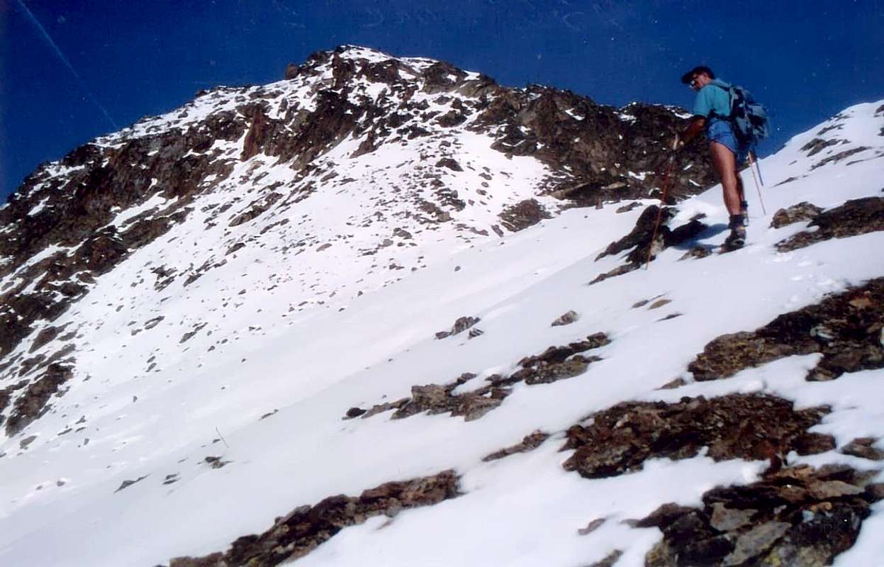
![The last 80 meters to reach...]()
![Mont Fallère Summit after Northern Little Wall 1972]()
![Il versante n-e del mont Fallère (3061 m.)]()
![il versante n-e del mont...]()
AVVICINAMENTI Per raggiungere questo versante si deve d'obbligo transitare dalla Valle del Gran San Bernardo con tre differenziate possibilità d'avvicinamento, partendo dalla sua parte medio-bassa tramite la Strada Statale n° 27, che conducono nel Vallone di Flassin, ovvero dai Villaggi di Condemine, Echevennoz o dal Comune di Etroubles.1) - dal Comune di Gignod (988 m) raggiungere la strada alternativa Municipale e, svoltando a sinistra raggiungere la località chiamata Condemine (1.137 m); dopo averla sorpassata proseguire per i Villaggi di Grand e Petit Buthier (1.302 m, 1.439 m; fontana) all'ingresso della Comba Chaligne; lasciando a sinistra (Sud) la breve deviazione per Clemencey (1.409 m), si continua invece dapprima verso Ovest raggiungendo Mendey (1.547 m) e quindi più a Sudovest in direzione degli Alpeggi di Roncaille, Rombason (1.656 m, 1.695 m) arrivando al bivio 1.723 metri per Arolla Dèsott ed il successivo per Damon. Scartatili entrambi sempre a sinistra pervenire, presso un tornante ad angolo acuto, la successiva deviazione; abbandonata la strada che prosegue verso Sud raggiungendo il nuovo Rifugio Chaligne (1.936 m), si continua a destra (Nordovest) tramite un'altra strada poderale che raggiunge l'Alpeggio isolato di Collet (1.919 m). La medesima, doppiando la Costa o Cresta Tardiva (2.380 m), prosegue tramite un lungo diagonale verso Sudovest ed affiancando il Ru (Ruscello per l'irrigazione) Collet progressivamente s'introduce nel Vallone dell'Arsy; attraversato l'omonimo Torrent raggiunge l'Alpe d'Ars (1.975 m) e la Tsa d'Ars (2.263 m), o siddetto ultimo superior alpeggio (E; 1h'45/2h'00 da Mendey).2) - dalla Frazione di Echevennoz (1.233-1.264 m; "Ei qui ven à nos" cioé acque che vengono a noi, dal corso del soprastante torrente proveniente dal Vallone dell'Ars; Ostello Marietty), raggiungibile con breve deviazione dalla Strada Statale, e partendo dal settore superiore, cosiddetto Dessus, tramite una breve strada poderale, oppure leggermente più a destra (Ovest) per mezzo del sentiero, arrivare ad un villaggetto (1.408 m; si può giungere fino a qui anche con la poderale che, transitando alta da Nordovest verso Sudest sopra Echevennoz, connette i Villaggi presso Lavanche (all'incirca 1.300 m) a quello di Gariache (1.472 m). Da questo, con sentiero verso Meridione ed attraverso la foresta, raggiungere il Villaggio d'Eteley (1.716 m), nonché la successiva via che proviene dal viciniore Etroubles; quest'itinerario, a nostro avviso, risulta certamente il più consigliabile tra i tre descritti, poiché via più pratica nonché maggiormente diretta (E; 2h'00/2h'15).3) - dal Comune di Etroubles (1.270 m), tramite il sentiero concomitante con la strada poderale fino al bivio 1.400 m~ subito dopo l'Alpe Lavanche e prima di Champ-Reclos (1.425 m); lasciata sulla sinistra (Sudest) una deviazione secondaria, si continua invece in direzione opposta sulla strada principale raggiungendo progressivamente gli Alpeggi di Yettes (1.591 m), ed attraversando il Bois de Peson e scartando a destra un'ulteriore ramificazione verso Teppes (1.879 m), quello a seguire di Eteley. Proseguendo verso il fondovalle ed attraversando il Torrent d'Ars, si raggiunge un bivio immediatamente prima dell'Alpe Praz-Gallet (1.626 m), che si lascia sulla sinistra; da questo infine con un lungo diagonale a Sud-sudest nel bosco si raggiunge l'Alpe di Ars, donde alla precedente via (E; 2h'15/2h'30).VIA Il Versante Settentrionale si sdoppia in due facce: una più a Nord-nordest é compresa tra la Cresta Est-nordest (vedi l'itinerario sottostante) ed un grande pilastro di rocce rotte rivolto decisamente a Nord; oltre questo un largo versante detritico-roccioso si allunga da sinistra (Est) a destra verso lo Spallone (2.971/3 m) della Cresta Nordovest nel suo ramo più Settentrionale, che scende al Colle d'Ars tra l'omonimo vallone ed il laterale di Flassin. Mentre il primo risulta del tutto sconsigliabile, se non con le eccezioni suggerite nel successivo itinerario, per quanto concerne il secondo é da annotare come il medesimo costituisca la "Via Normale" arrivando dal Vallone del Gran San Bernardo; ciononostante é scarsissimamente frequentato, anche se la costruzione del Bivacco della Forestale negli ultimi anni può aver allargato il numero delle visite, almeno, essendo privato e chiuso, da parte delle Guardie Forestali medesime. Forse in un lontano passato, allorché sul Versante Meridionale non esistevan l'attuali strade poderali facilitanti l'avvicinamento, lo era maggiormente poiché i dislivelli da percorrersi erano quasi uguali tanto che risulta essere stato effettuato pur in discesa nel 1904; oggigiorno in pratica é caduto quasi completamente nell'oblio anche pel fatto che la quasi totale assenza di nevati (fino ad una quarantina d'anni orsono presenti fino a stagione inoltrata) rende la salita alquanto noiosa e del tutto priva di sentiero. A sua volta, comunque, questa faccia si divide in due settori ben distinti: una, in genere detritica con qualche roccetta nella parte terminale, rivolta più ad Oriente che culmina sullo Spallone a 220 m~ dalla vera Cima ed una seconda nettamente più rocciosa sottostante alla stessa ed allungantesi insino alla Quota 2.971/3 m o Spallone opposto. Quest'ultima che fino al 1971 risultava ancora inesplorata, é stata salita direttamente e, forse, per l'unica volta nel 1972; in ogno caso diviene salita sconsigliata e pericolosa per la ripidezza e cattiva qualità delle rocce nella parte finale. Limitiamo quindi la descrizione esclusivamente al primo itinerario, per così dire "classico o tradizionale". Dall'Alpe di Arsy, raggiunta con uno dei tre Avvicinamenti sopra descritti, salire portandosi progressivamente verso Sudest tramite pendii e gobbe detritico-erbose; lasciando a destra (Ovest) i tre Laghetti d'Arsy, indirizzarsi verso la base del Pilastro Nord in altituidine 2.776 metri. Non raggiungerla bensì, passandole subito sulla destra (Ovest), salire per mezzo di finissimo al punto d'apparir "tritato" nonché noioso detrito od, in inizio di stagione, nevati con pendenza dai 30° ai 38° (generalmente in neve durissima e tal da richiedere la necessità d'aver seco piccozza, se non ramponi); arrivare quindi con salita sempre più ripida a quota 2.970/80 m~. Poggiando in diagonale sempre più sulla sinistra negli ultimi 70 metri pervenire allo Spallone o Sommità Orientale e con una traversata di 220 m~ sulla Cresta Est, attrezzata da pochi anni con catene, raggiungere la vera Sommità (EE/A/ da F a F+; 2h'00/2h'30 dalla Tsa d'Arsy; 3h'30/4h'15 nel totale). ![]()
The traverse on East-northeast Crest integrally or by Eastern Face in watershed from Met or Buthier or Variant by Thouraz
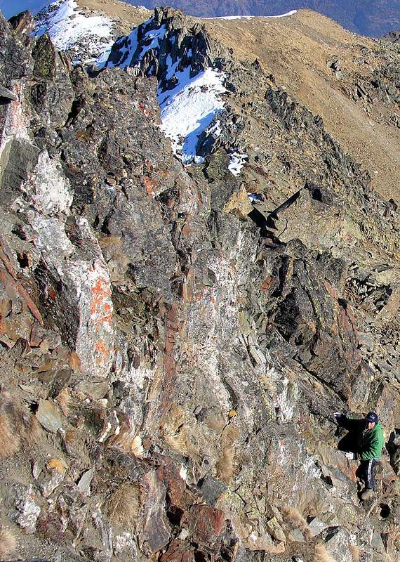
![]() Finally we analyze this ridge that descends from the great Shoulder 3.040/3 meters to an unnamed hill below 2.670 meters in altitude; this was certainly true in that passage "Alta Via delle Alpi" (High Route of the Alps) in past centuries led, across the whole of Europe, very ancient via from Amsterdam to the Venetian and vice versa. In fact it is more than mere transit as opposed Colle Finestra (Window; 2.941m) and with lower altitude to accomplish; both lead in the Vallon of Arsy or Vallon d'Ars, above the Municipalities of Etroubles and Saint Oyen on the road to the Great Saint Bernard. But it was the very ancient Hamlet of Thora (today rebuilt more in East as Thouraz) indicating the passage; completely buried by a enormous landslide from Becca France (2.312m) just behind him with all 600 residents at dawn on Jul 6th, 1564, it offered four great Fairs of European fame, among whom was the famous one turned to "Seed". A pass so ancient, popular and frequented fell, after the sad event, most complete anonymity, as was the East-northeast Ridge of Mount Fallère. No one thought to go up that way and this almost to the present day. Made this premise, we go to "view" this ridge that descends briefly above the aforementioned hill, but then rises again to form along the watershed dividing the Central Valley of Dora Baltea from the North of the Great Saint Bernard Pass and which would constitute his natural extension orographic up above the Town of Aosta. With three small walls on ridge the same reaches the Mont d'Arsy (2.826m) down to a small saddle (2.655m), above what is known as "Costa Mayan", and, turning gradually toward the Southeast, in succession reaches the Mont de la Tsa (2.741/2m) Punta Chaligne or Pointe Tzaligne (2.608m) and, after the Hill of Met or Metz, ends with the eponymous Point (2.553m). Furthermore, it is possible to join on the same ridge starting from the Valley of the Great St. Bernard Condemine-Buthier Villages (1.137m, 1.302m) and climb to new Chaligne Refuge (1.936m); this in a short time you reach the Tardiva Hill (2.410m) and through the easy Ridge North you come to Tsa, whence the previous route to the Summit. In any case, the crest looks long but easy and only descent through the West Ridge of Mont d'Arsy requires caution: it is necessary to find the way along the rocks and dangerous routes with three small walls allege the hill below. The final part, or true East-northeast ridge, it is boring and fine debris and rocks formed by somewhat broken and rotten; only in the last meters of the same require a little effort and vigilance, because they increase in steepness (I°+/II°-); caution: in early season great snow frame just off the great Shoulder 3.040/3 meters. In this case, deviate more to the right (North) and, crossing the narrow Slope North-northeast, reaching the imposing pillar that splits in two the North Face; this climb, passing a small rock wall along the Northern Ridge, reaching the same shoulder. On the contrary, with the path "dry", avoid this crossing exposed to falling rocks and climb faithfully on the edge of the ridge. (EE/A/F+/PD-; 1h'00 from the hill; 3h'30/4h'00 by Punta Met or Chaligne Shelter; 5h'00/6h'00 a total from the departure).Variant: it is also possible to climb the Eastern Face with a deviation from the predicted crest (not recommended) or directly from the bottom along the valley that from Thouraz New (1.593m) reach Lake Fallère (2.415m) with the usual way to the Tsa de Morgnoz Pasture (2.205m) to reach the altitude 2.276 meters, where the dirt road ends. From the lake back to the Northeast up to the altitude of 2.520 metres entering the small vallon with the Mont d'Arsy. With path between small Torrents des Feuilles Mortes and Carteresse reach the stony ground at the base of the Eastern Slope. From this climb along a back side of a barely visible rib on the left until you reach the first terminals rocks and finally the triangular partition wall terminal. With this delicate and exposed climbing both for the above exhibition and for the bad quality of the rock conclude on Punta Eastern or Spallone 3.043 meters (EE/A/F+/PD-/PD/PD+; 1h'00/1h'15 from base; 2h'00/2h'15 Fallère Loch; 3h'30/4h'00 by junction 1.638 metres with ban, just after the Thouraz small Villages).
Finally we analyze this ridge that descends from the great Shoulder 3.040/3 meters to an unnamed hill below 2.670 meters in altitude; this was certainly true in that passage "Alta Via delle Alpi" (High Route of the Alps) in past centuries led, across the whole of Europe, very ancient via from Amsterdam to the Venetian and vice versa. In fact it is more than mere transit as opposed Colle Finestra (Window; 2.941m) and with lower altitude to accomplish; both lead in the Vallon of Arsy or Vallon d'Ars, above the Municipalities of Etroubles and Saint Oyen on the road to the Great Saint Bernard. But it was the very ancient Hamlet of Thora (today rebuilt more in East as Thouraz) indicating the passage; completely buried by a enormous landslide from Becca France (2.312m) just behind him with all 600 residents at dawn on Jul 6th, 1564, it offered four great Fairs of European fame, among whom was the famous one turned to "Seed". A pass so ancient, popular and frequented fell, after the sad event, most complete anonymity, as was the East-northeast Ridge of Mount Fallère. No one thought to go up that way and this almost to the present day. Made this premise, we go to "view" this ridge that descends briefly above the aforementioned hill, but then rises again to form along the watershed dividing the Central Valley of Dora Baltea from the North of the Great Saint Bernard Pass and which would constitute his natural extension orographic up above the Town of Aosta. With three small walls on ridge the same reaches the Mont d'Arsy (2.826m) down to a small saddle (2.655m), above what is known as "Costa Mayan", and, turning gradually toward the Southeast, in succession reaches the Mont de la Tsa (2.741/2m) Punta Chaligne or Pointe Tzaligne (2.608m) and, after the Hill of Met or Metz, ends with the eponymous Point (2.553m). Furthermore, it is possible to join on the same ridge starting from the Valley of the Great St. Bernard Condemine-Buthier Villages (1.137m, 1.302m) and climb to new Chaligne Refuge (1.936m); this in a short time you reach the Tardiva Hill (2.410m) and through the easy Ridge North you come to Tsa, whence the previous route to the Summit. In any case, the crest looks long but easy and only descent through the West Ridge of Mont d'Arsy requires caution: it is necessary to find the way along the rocks and dangerous routes with three small walls allege the hill below. The final part, or true East-northeast ridge, it is boring and fine debris and rocks formed by somewhat broken and rotten; only in the last meters of the same require a little effort and vigilance, because they increase in steepness (I°+/II°-); caution: in early season great snow frame just off the great Shoulder 3.040/3 meters. In this case, deviate more to the right (North) and, crossing the narrow Slope North-northeast, reaching the imposing pillar that splits in two the North Face; this climb, passing a small rock wall along the Northern Ridge, reaching the same shoulder. On the contrary, with the path "dry", avoid this crossing exposed to falling rocks and climb faithfully on the edge of the ridge. (EE/A/F+/PD-; 1h'00 from the hill; 3h'30/4h'00 by Punta Met or Chaligne Shelter; 5h'00/6h'00 a total from the departure).Variant: it is also possible to climb the Eastern Face with a deviation from the predicted crest (not recommended) or directly from the bottom along the valley that from Thouraz New (1.593m) reach Lake Fallère (2.415m) with the usual way to the Tsa de Morgnoz Pasture (2.205m) to reach the altitude 2.276 meters, where the dirt road ends. From the lake back to the Northeast up to the altitude of 2.520 metres entering the small vallon with the Mont d'Arsy. With path between small Torrents des Feuilles Mortes and Carteresse reach the stony ground at the base of the Eastern Slope. From this climb along a back side of a barely visible rib on the left until you reach the first terminals rocks and finally the triangular partition wall terminal. With this delicate and exposed climbing both for the above exhibition and for the bad quality of the rock conclude on Punta Eastern or Spallone 3.043 meters (EE/A/F+/PD-/PD/PD+; 1h'00/1h'15 from base; 2h'00/2h'15 Fallère Loch; 3h'30/4h'00 by junction 1.638 metres with ban, just after the Thouraz small Villages).![Il versante nord est...]()
![Il versante n-e del mont...]()
![M. Fallère The long shadows of the very long Ridge East-northeast 1974]()
![Il versante est del mont...]()
![Mont Fallère]() In ultimo analizziamo questa cresta discendente dallo Spallone 3.040/3 metri verso un sottostante colle innominato in quota 2.670 metri; sicuramente era questo il vero passaggio che nell'"Alta Via delle Alpi" nei secoli scorsi conduceva, attraversando l'intera Europa, da Amsterdam alle Venezie e viceversa. Infatti risulta di più semplice transito rispetto all'opposto Colle Finestra (2.941 m) e con minore dislivello da compiersi; entrambi conducono nel Vallone di Arsy o d'Ars, al di sopra dei Comuni di Etroubles e di Saint Oyen sulla via pel Gran San Bernardo. Ma era l'antico Villaggio di Thora (oggigiorno ricostruito più ad Oriente come Thouraz) che ne indicava il transito; completamente sepolto da una frana dalla Becca France (2.312 m) alle sue spalle con tutti i 600 abitanti all'alba del 6 Luglio 1564, offriva quattro grandi Fiere di fama Europea, tra le quali era celebre quella rivolta alle "Sementi". Un valico quindi antico, popolare e frequentato caduto, dopo il triste evento, nell'anonimato più completo, com'era la Cresta Nordest del Mont Fallère. Nessun pensava di salir da quella parte e questo quasi fin ai giorni nostri. Effettuata questa doverosa premessa, andiamo a "visionare" questa cresta che brevemente scende sopra il suddetto valico, ma in seguito si rialza a formare quel lungo spartiacque divisorio la Valle Centrale della Dora da quella Settentrionale del Gran San Bernardo e tale da costituire il suo naturale prolungamento orografico fino al di sopra della Città d'Aosta. Con tre piccoli risalti la stessa raggiunge il Mont d'Arsy (2.826 m) scende ad una selletta (2.655 m), sopra quella che é conosciuta come "Costa Mayan" e, volgendo progressivamente verso Sudest, raggiunge in successione il Mont de la Tsa (2.741/2 m) la Punta Chaligne o Tzaligne (2.608 m) e, dopo il Colle di Met o Metz, si conclude con l'omonima Punta (2.553 m). Inoltre risulta possibile inserirsi sulla stessa cresta con partenza dalla Valle del Gran San Bernardo da Condemine-Buthier (1.137 m, 1.302 m) e salita al nuovo Rifugio Chaligne (1.936 m); da questo in breve tempo si raggiunge il Passo Tardiva (2.410 m) e tramite la facile Cresta Settentrionale si perviene alla Tsa, donde alla precedente via. In ogni caso la cresta si presenta lunga ma facile e soltanto la discesa tramite la Cresta Ovest del Mont d'Arsy richiede cautela: é necessario trovare la via lungo rocce rotte e pericolose che con tre muretti adducono al colle sottostante. La parte finale, o vera e propria Cresta Est-nordest, risulta noiosa e formata da fine detrito e rocce alquanto rotte; solo negli ultimi metri le medesime richiedono un poco di impegno e vigilanza, perché aumentano in ripidezza (I°+/II°-); attenzione, in inizio di stagione, al cornicione d'uscita sullo Spallone 3.040/3 m. In codesta situazione, conviene traversare completamente l'angusto Versante Est-nordest raggiungendo il grande pilastro che spezza in due la Faccia Settentrionale; da questo, dopo aver superato un muretto, continuare lungo la Cresta Nord insino alla spalla. Contrariamente, in caso di percorso "asciutto", evitare questa variante esposta alla caduta di pietre e proseguire più fedelmente sul fil di cresta. (EE/A/F+/PD-; 1h'00 dal colle; 3h'30/4h'00 dalla Punta di Met o dal Rifugio Chaligne; 5h'00/6h'00 dalle basi di partenza).Variante: é inoltre possibile risalire la Faccia Est con una deviazione dalla predetta cresta (non consigliabile) oppure direttamente dal basso percorrendo il vallone che da Thouraz Nuova (1.638 m)raggiunge il Lago Fallère (2.415 m) con la solita via della Tsa de Morgnoz (2.205 m) fino a raggiungere la quota 2.276 metri, dove la strada poderale termina. Dal lago risalire verso Nordest fino all'altitudine di 2.520 metri entrando nel valloncello con il Mont d'Arsy. Con percorso tra i torrentelli des Feuilles Mortes e Carteresse raggiungere la pietraia alla base del Versante Orientale. Da questa risalire a fianco d'una costola appena accennata sulla sinistra fino a raggiungere dapprima le rocce terminali ed infine la triangolare paretina terminale. Con questa ed arrampicata delicata sia per l'esposizione che per la cattiva qualità della roccia concludere sulla Punta Orientale o Spallone 3.043 metri (EE/A/F+/PD-/PD/PD+; 1h'00/1h'15 dalla base; 2h'00/2h'15 dal Lago Fallère; 3h'30/4h'00 dal bivio 1.638 metri con cartello di divieto, subito dopo i Villaggetti di Thouraz).
In ultimo analizziamo questa cresta discendente dallo Spallone 3.040/3 metri verso un sottostante colle innominato in quota 2.670 metri; sicuramente era questo il vero passaggio che nell'"Alta Via delle Alpi" nei secoli scorsi conduceva, attraversando l'intera Europa, da Amsterdam alle Venezie e viceversa. Infatti risulta di più semplice transito rispetto all'opposto Colle Finestra (2.941 m) e con minore dislivello da compiersi; entrambi conducono nel Vallone di Arsy o d'Ars, al di sopra dei Comuni di Etroubles e di Saint Oyen sulla via pel Gran San Bernardo. Ma era l'antico Villaggio di Thora (oggigiorno ricostruito più ad Oriente come Thouraz) che ne indicava il transito; completamente sepolto da una frana dalla Becca France (2.312 m) alle sue spalle con tutti i 600 abitanti all'alba del 6 Luglio 1564, offriva quattro grandi Fiere di fama Europea, tra le quali era celebre quella rivolta alle "Sementi". Un valico quindi antico, popolare e frequentato caduto, dopo il triste evento, nell'anonimato più completo, com'era la Cresta Nordest del Mont Fallère. Nessun pensava di salir da quella parte e questo quasi fin ai giorni nostri. Effettuata questa doverosa premessa, andiamo a "visionare" questa cresta che brevemente scende sopra il suddetto valico, ma in seguito si rialza a formare quel lungo spartiacque divisorio la Valle Centrale della Dora da quella Settentrionale del Gran San Bernardo e tale da costituire il suo naturale prolungamento orografico fino al di sopra della Città d'Aosta. Con tre piccoli risalti la stessa raggiunge il Mont d'Arsy (2.826 m) scende ad una selletta (2.655 m), sopra quella che é conosciuta come "Costa Mayan" e, volgendo progressivamente verso Sudest, raggiunge in successione il Mont de la Tsa (2.741/2 m) la Punta Chaligne o Tzaligne (2.608 m) e, dopo il Colle di Met o Metz, si conclude con l'omonima Punta (2.553 m). Inoltre risulta possibile inserirsi sulla stessa cresta con partenza dalla Valle del Gran San Bernardo da Condemine-Buthier (1.137 m, 1.302 m) e salita al nuovo Rifugio Chaligne (1.936 m); da questo in breve tempo si raggiunge il Passo Tardiva (2.410 m) e tramite la facile Cresta Settentrionale si perviene alla Tsa, donde alla precedente via. In ogni caso la cresta si presenta lunga ma facile e soltanto la discesa tramite la Cresta Ovest del Mont d'Arsy richiede cautela: é necessario trovare la via lungo rocce rotte e pericolose che con tre muretti adducono al colle sottostante. La parte finale, o vera e propria Cresta Est-nordest, risulta noiosa e formata da fine detrito e rocce alquanto rotte; solo negli ultimi metri le medesime richiedono un poco di impegno e vigilanza, perché aumentano in ripidezza (I°+/II°-); attenzione, in inizio di stagione, al cornicione d'uscita sullo Spallone 3.040/3 m. In codesta situazione, conviene traversare completamente l'angusto Versante Est-nordest raggiungendo il grande pilastro che spezza in due la Faccia Settentrionale; da questo, dopo aver superato un muretto, continuare lungo la Cresta Nord insino alla spalla. Contrariamente, in caso di percorso "asciutto", evitare questa variante esposta alla caduta di pietre e proseguire più fedelmente sul fil di cresta. (EE/A/F+/PD-; 1h'00 dal colle; 3h'30/4h'00 dalla Punta di Met o dal Rifugio Chaligne; 5h'00/6h'00 dalle basi di partenza).Variante: é inoltre possibile risalire la Faccia Est con una deviazione dalla predetta cresta (non consigliabile) oppure direttamente dal basso percorrendo il vallone che da Thouraz Nuova (1.638 m)raggiunge il Lago Fallère (2.415 m) con la solita via della Tsa de Morgnoz (2.205 m) fino a raggiungere la quota 2.276 metri, dove la strada poderale termina. Dal lago risalire verso Nordest fino all'altitudine di 2.520 metri entrando nel valloncello con il Mont d'Arsy. Con percorso tra i torrentelli des Feuilles Mortes e Carteresse raggiungere la pietraia alla base del Versante Orientale. Da questa risalire a fianco d'una costola appena accennata sulla sinistra fino a raggiungere dapprima le rocce terminali ed infine la triangolare paretina terminale. Con questa ed arrampicata delicata sia per l'esposizione che per la cattiva qualità della roccia concludere sulla Punta Orientale o Spallone 3.043 metri (EE/A/F+/PD-/PD/PD+; 1h'00/1h'15 dalla base; 2h'00/2h'15 dal Lago Fallère; 3h'30/4h'00 dal bivio 1.638 metri con cartello di divieto, subito dopo i Villaggetti di Thouraz).![]()
Routes Difficulties
All Roads lead to the Summit ![]()
![]()
![]()
When To Climb
The best period is from July to September; I went at the end of October, it depends also from the season. In winter it is possible to make sky mountanering, usually in April, but it's better to ask information in the area; after fresh snow, please avoid.....Campings
In Aosta Valley it's possible to camp only over 2.500 meters.![]()
Miscellaneous Info
Interesting places in the area You will find a few informations on the area, including some hotels addresses on the site: Comune di Saint Nicolas and some others indication on the site: Inalto![]()
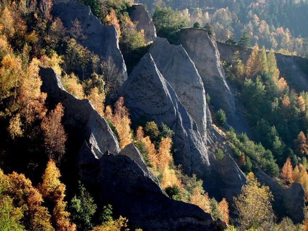
Calanchi close to Saint Nicolas
Books and Maps
BOOKS:- "Guida dei Monti d'Italia-Alpi Pennine" (Vol. I°) di Gino Buscaini-Club Alpino Italiano/Turing Club Italiano, Luglio 1971.
- "Dove si specchia il cielo - i laghi della Valle d'Aosta", di Sergio Piotti, Ed. Ferrari Luglio 1996.
- "80 itinerari di Escursionismo Alpinismo e Sci Alpinismo in Valle d'Aosta", di Osvaldo Cardellina, Ed. Musumeci, Giugno 1977 (in Italian); seconda Ed. Luglio 1981; terza Ed. Luglio 1984; (in French), prima Ed. Febbraio 1978; seconda Ed. Marzo 1980.
MAPS:![]()
![]()
![]()
- Kompass "Monte Bianco Valle d'Aosta Sentieri e Rifugi" Carta turistica 1:50.000.
- Kompass "Gran Paradiso Valle d'Aosta Sentieri e Rifugi" Carta Turistica 1:50.000.
- I.G.C. Istituto Geografico Centrale Torino "Massiccio del Monte Bianco" (n° 4), Torino, 1998 1:50.000.
- Studio F.M.B. "Monte Bianco-Mont Blanc", Bologna 1988 1:50.000.
- I.G.C. Istituto Geografico Centrale "Carta dei sentieri e dei rifugi" 1:25.000.
- I.G.M. Istituto Geografico Militare 1:25.000.
Important Information
- REGIONE AUTONOMA VALLE D'AOSTA the official site.
- FONDAZIONE MONTAGNA SICURA Villa Cameron, località Villard de la Palud n° 1 Courmayeur (AO) Tel: 39 0165 897602 - Fax: 39 0165 897647.
- A.I.NE.VA. (Associazione Interregionale Neve e Valanghe).
Useful numbers
- Protezione Civile Valdostana località Aeroporto n° 7/A Saint Christophe (Ao) Tel. 0165-238222.
- Bollettino Meteo (weather info) Tel. 0165-44113.
- Unità Operativa di Soccorso Sanitario Tel. 118.