
|
|
Route |
|---|---|
|
|
38.62540°N / 106.3855°W |
|
|
Mountaineering |
|
|
Summer |
|
|
Most of a day |
|
|
Hike |
|
|
Getting There
Directions to the ghost town of Hancock:From the town of Buena Vista drive 8 miles south on Route 285 to a place known as Nathrop and then turn west onto Route 162. Drive this road 15.3 miles to just before the ghost town of St. Elmo (the first 10 miles are paved and the rest is a well graded dirt road).
Turn left onto Route 295. This road is rougher but is still passable by most/any car. Continue 2.7 miles until you see a detour around an old decaying railroad bridge (The detour is rather steep and the road beyond it is much rougher. I did not need to use 4 wheel drive but I will probably not drive this road in anything less than an SUV). Continue another 2.8 miles to the remains of the old mining town of Hancock.
Route Description
All distances are per my GPS.Place…………..Elevation (ft)………….Distance (miles)
Ghost Town
Of Hancock……11050………………….Zero
Hancock
Pass…………….12100…………………..2.2
Chapman………...12755…………………0.9
Total………………………………………….3.1 miles
At the ghost town of Hancock you will see a trail that heads west to the old Alpine Tunnel. Do not go there. Head south on a rough Jeep Trail to Hancock Lakes and Hancock Pass. After a very short distance, you will see a Jeep Trail on the right (west). Turn right onto the trail to Hancock Pass (going straight (south) will take you to Hancock Lakes and Chalk Creek Pass).

Jeep Trail
Follow the Jeep Trail through the pine forest and above tree-line to reach Hancock Pass.

High Point from Hancock Pass
At the pass, leave the trail and head directly up a steep grassy slope to reach the first high point (USGS contour lines 12720-12760 ft). Follow the ridge-top down roughly 100 vertical feet and then up again to reach the summit of Chapman.
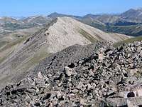
Chapman from High Point