
-
 6183 Hits
-
 74.92% Score
-
 5 Votes
|
|
Route |
|---|---|
|
|
39.13440°N / 105.4576°W |
|
|
Hiking, Scrambling |
|
|
Spring, Summer, Fall, Winter |
|
|
Less than two hours |
|
|
Overview
 Easy scramble
While this route is short in mileage and mellow in elevation gain, it provides a good mix of trail hiking, route-finding on faint footpaths and easy scrambling. This is a great option to combine with other objectives, share with children or out of town visitors, or save for a day when time or energy constraints call for an easy outing. The views from the open rock summit are fantastic and the scrambling and route finding on the southeast slope just interesting enough to keep things from being a slog.
Roundtrip Distance: 2 miles
Elevation Gain: 600 feet
YDS Class: 2+ - 3
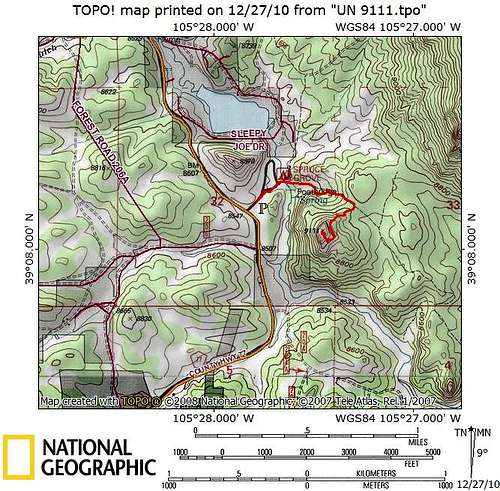
Getting There
 Ascending the southeast slopes
 Eroded footpath
This route to the summit of UN 9111 starts at the Spruce Grove Campground, operated by the National Forest Service. This campground sits just to the east of Park County Road 77. From the intersection of US Hwy 24 and CR 77 near Lake George, travel about 12 miles northwest on CR 77 and turn right/east toward the Spruce Grove Campground. Day visitors should park at the gate above the campground near the road.
Route Description
 Crossing the bridge
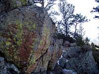 Hiking through the rock garden
 Follow this ramp south-southeast
• Park at the day use gate and walk downhill to Spruce Grove Campground.
• Head into the campers parking area then behind outhouses. Follow the trail across footbridge.
• Continue uphill (do not turn left onto marked trails like the one to Lizard Rock) through the campground.
• Continue between/through spots 6 and 7 on footpath, and then continue eastbound on the unmarked footpath past the campground.
• After a brief stroll through an Aspen meadow, encounter a steep, eroded section of the footpath.
• Continue uphill through to saddle trending southeast.
• At the top of the saddle, leave the trail and turn southwest directly toward the mountain.
• The off-trail segment begins very as a gentle ascent and then steepens into a rock garden of granite and Ponderosa Pine with some Douglas Fir.
• You should notice very faint signs of social path as you get higher on the route.
• A short time after leaving the trail, you will run into cliff. Here you want to turn left/south-southeast, and follow faint path along base of cliff through the duff and tree branches along a gradual ramp through the trees.
• On the southeast side of the peak you will find the weakness enabling your ascent, a series of shelves, ramps and cleft.
o *Make a mental note of where you leave the trees to ensure a quick an easy return/descent.
• Zigzag up the southeast face to the summit boulder on the far northeastern end of the summit area. Enjoy fantastic, wide-open views before retracing your steps.
Essential Gear
 Looking back to parking
 UN 9111 from parking area
Essential gear for this hike and easy scramble is pretty basic:
• Standard hiking equipment appropriate to the season.
• A map and compass and/or GPS for navigation. For this outing, I recommend using a zoomed-in custom map, such the one provided on this page or your own TOPO! Map.
• A good sense of route finding and direction to follow the route up to the summit, and return safely without getting marooned on the southeast side of the peak because you cannot relocate the descent weakness.