
-
 5570 Hits
-
 82.48% Score
-
 15 Votes
|
|
Mountain/Rock |
|---|---|
|
|
39.13440°N / 105.4576°W |
|
|
Park |
|
|
Hiking, Scrambling |
|
|
Spring, Summer, Fall, Winter |
|
|
9111 ft / 2777 m |
|
|
Overview
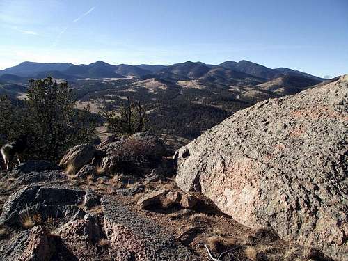
Granite Boulder and Puma Hills from the UN 9111 summit
This cool little rocky wonder is easily one of my favorite 9,000 footers near the Colorado Front Range metropolitan areas. This steep but petite jumble of granite offers up a lot of bang for the buck. From a distance, it may appear this peak would not permit a non-technical acent, bit the southeast aspect offers a hidden surprise. Indeed, a dog can ascend this nifty little peak where the difficulty does not exceed a stiff YDS Class 2+.
The surprisingly broad summit plateau is the perfect place to kick back and take in the views or explore a bit. The sheer walls of the peak dropping away from the summit plateau allows for cool aerial views of the surrounding valley. Close-up views of the Tarryall Mountains, particularly South Tarryall Peak and McCurdy Mountain, delight. Fourteener Pikes Peak shows itself in the distance to the southeast, while high Thirteener Bald Mountain pushes its bulky mass toward to sky to the west.
Rank: 2861st highest peak in Colorado
Prominence: 331 feet
USGS Quad: McCurdy Mountain
Recreation Map: Trails Illustrated #105 Tarryall Mts | Kenosha Pass
Rank & Prominence Source: http://listsofjohn.com/PeakStats/Climbers.php?Id=4025
Getting There

High wispy clouds
Southeast from summit
UN 9111 sits just to the east of Park County Road 77. From the intersection of US Hwy 24 and CR 77 near Lake George, travel about 12 miles northwest on CR 77 to the Spruce Grove Campground.
Red Tape

Enjoying the summit area

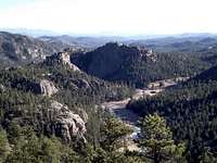
Up the Tarryall Valley
There is little red tape governing recreational use in this part of the National Forest and there is no fee to access this area. Adhere to LNT (Leave No Trace) principals, observe fire ban when in effect and do not harass wildlife or allow your pet to do so.
When ascending the peak via the Spruce Grove Campground, as most visiters will do, please be respectful of those camping. Give them their space and privacy, even as you must tiptoe through the campground to reach the peak.
Camping
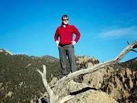
On the summit of UN 9111

UN 9111 summit jar
Designated National Forest Service Sites
The National Forest Service has a large selection of campgrounds in and around the Lake George area, not far from UN 9111. The closest are Spruce Grove (right below the peak) and Twin Eagles, just a few miles north. Please check with the Forest Service in advance during shoulder season regarding seasonal closures for campgrounds.
| Campground Name | Elevation | Sites | Nightly Rate | Reservations? | Notes |
|---|---|---|---|---|---|
| Blue Mountain | 8,200 ft. | 21 | $12 | Yes | Less than 3 miles as the crow flies from the summit of Blue Mountain. |
| Spruce Grove | 8,600 ft. | 27 | $12 | No | Let the gurgling Tarryall Creek sing you to sleep. |
| Twin Eagles | 8,600 ft. | 9 | $8 | No | Must haul or purify drinking water. |
| Happy Meadows | 7,900 ft. | 8 | $12 | No | Situated along the South Platte River. |
| Round Mountain | 8,500 ft. | 16 | $12 | Yes | Drinking water, vault toilet and trash pickup. |
| Springer Gulch | 8,300 ft. | 15 | $12 | Yes | Situated within the Elevenmile Canyon; water, tables, fire grates. |
| Riverside | 8,000 ft. | 19 | $12 | Yes | Situated within Elevenmile Canyon; large grassy meadow with little shade. |
Weather & Seasons
South Tarryall Peak

Summit area of UN 9111

UN 9111 from the northeast

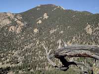
Bald Mountain rises to the west
Note: The primary route to the summit of this peak requires walking right through the Spruce Grove Campground on a social trail. It is recommended that this peak be visited when the campground is closed, and certainly not in high season (mid-summer). This will give campers some quiet and privacy and avoid any awkward moments as you walk through the campground.
Summer: The air temperature may be a little warm in the summer and the area quite crowded.
Spring: The snowpack is less deep here than in the high country and melts out faster than higher areas to the west. None-the-less, expect post-holing through unconsolidated snow drifts in the trees.
Fall: The aspen coating the slopes of area peaks make this area a golden-hued heaven in the fall. The Tarryall Valley is a special autumn treat.
Winter: Thanks to proximity to CR 77, this peak is accessible in all but the most epic snowfalls.
Jeremy Hakes - Oct 30, 2011 3:56 pm - Voted 10/10
Coords?Might want to add the coords to this peak.... :)
Sarah Simon - Nov 5, 2011 11:42 am - Hasn't voted
Re: Coords?Hmmm...it must have been a 12-year Glenfiddich night when I posted this. My bad... Good catch, thank you! Sarah
eldoce - May 16, 2018 1:12 pm - Voted 10/10
Class 3-4 route up the wallI have climbed the upper wall unroped from the campground in like 1-2 hours. With care to find the easiest route, rock should not exceed class 3, but the most obvious route is class 4. Route goes diagonal left to right from about the middle of the upper portion of the wall. The backside ascent described above is not nearly as rewarding as the scramble up the front side, in my experience.