
|
|
Route |
|---|---|
|
|
36.06098°N / 51.55260°E |
|
|
Mountaineering |
|
|
Summer |
|
|
A few days |
|
|
Hike+Class III/IV |
|
|
Getting There
Directions to Varengeh Rood Village:From downtown Tehran drive the Tehran-Karaj Freeway 40 Km west to the town of Karaj and take the Chalus Road exit. Drive the Chalus Road up the mountains roughly 70 Km till the junction of the road that goes to Dizin Ski Area (2250 m). Turn onto this road and follow it a few Km till you see a side road on the left that goes to Varengeh Rood Village (2325 m). Turn onto this road and follow it a few Km till the end of it at the village (2450 m).
Route Description
Please refer to the Detailed Map of Central Alborz for the below discussion. Having the 1:50 000 maps (See the “Maps” section of Introduction to Central Alborz) can add much more detail. You will need Sheet “6262 II Gajereh” for Varengeh Rood Village and much of the valley and Sheet “6362 III Uz” for the Kholeno Peaks.All distances are per my GPS
Place…………….Elevation…………….Distance
Varengeh Rood
Village…………..2450 m……………….Zero
Junction
Of the
Stream to
Kholeno Lake…..3100 m……………….16.5 Km
Kholeno Lake…..3830 m………………..4.0 Km
Farakhe No……..4230 m………………..4.85 Km
Khers Chal………4253 m……………….0.5 Km
Kholeno
The Small……….4350 m………………..2.5 Km
Kholeno
The Great………..4387 m………………..0.65 Km
Kholeno
Lake via
Descending
West slopes……..3830 m…………………2.0 Km
Total………………………………………..31 Km
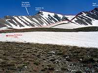
Get on the trail at the north end of the Varengeh Rood Village (2450 m). This trail soon crosses (via a bridge) to the northwestern side of the River (The river is too large to cross on foot). You will have to follow the river-side trail 16.5 Km to reach the junction of the branch that goes to Kholeno Lake. The trail is, for the most part, fairly well-established. We did, however, lose it at times. We were in the area in mid June. Avalanche remains covered the river frequently and provided convenient ways of crossing the river. Later in the season, when the snow has melted away, crossing the river will become a problem.
16.5 Km after Varengeh Rood Village, at an elevation of 3100 m, you will reach a split in the river. Turn right (south, and later southeast) and follow the southern branch up much steeper slopes another 4 Km to reach the Kholeno Lake (3830 m) which sits at the base of the northern slopes of Khers Chal Peak. The pointy summit of Khers Chal will guide you to the lake. Set up your base camp near the lake.
The western slopes of the Kholeno peaks above the Kholeno Lake are very steep and are covered by scree. This makes them a poor choice for climbing (they can be used as quick descend routes). The best option is to climb to the summit of Kherchal Peak and then follow the ridgetop to Kholeno.
Hike one Km back along the way that you came until you are directly to the north of Peak 4051 m (that rises between Farakhe No to the east and the 4118 m Bandalkoli Peak to the west). Identify the northern ridgeline of Peak 4051 m. This ridgeline might look intimidating, but if you stick just to the east of the crest of it, you will find a trail that takes you all the way to the summit of Peak 4051 m.
 Farakhe No & Peak 4051 m
Once on the summit of Peak 4051 m, turn east and follow the ridge-top down a little to a saddle and then up to the summit of Farakhe No and then Khers Chal.
Continue east on the crest of the ridgeline to a high point known as Harzeh Kooh (4268 m), then follow the ridgetop as it turns north toward the Borj Peaks. Bypass the first Borj Peak to the east of it and then go up the southern slopes of the second Borj Peak to its summit.
From the top of Borj Peak, continue down the ridgetop to reach the south and the middle Jhandark Needles (see main page). These present little technical challenge. Bypass the north Jhandark Needle to the east of it below its summit (see main page). You can then go up the easy southern slopes of Kholeno the Small and continue up to Kholeno the Great.
 East of N. Jhandark
From the summit of either of the Kholeno Peaks, you can go down the steep scree western slopes to reach the Kholeno Lake.