From Velan to Mont Blanc and to Rosa and beyond in time and space / 3

From Velan to Mont Blanc and to Rosa and beyond in time and space / 3

Page Type Page Type: Article
Activities Activities: Mountaineering

The Devils of Mont Blanc


Mont Blanc or MONT MAUDITE with tHE dEVILS OF vAL vENI, by Ilario Antonio Garzotto


We were left with: "A very hot summer has upset not only the men but also the mountains that, having lost their glue or "PERMAFROST", have become disjointed and, trembling, unglued. As the Mont Blanc. The walls of the V'lan have always been very dangerous, but even those of the Mont Blanc (4.810m), together with those of its satellites, are no less so. Indeed an ancient legend tells that the Val Veni, the one at the foot of its Southern Slope, was infested by a host of Devils. They went down to Primavera, abandoning their hiding places, to go down into the valley in search of the Witches with whom to mate. They camouflaged themselves in the guise of men, women, horses, mules and donkeys (never of jackass, ass idiot or dunce!) And wandered at night in the light of their torches. These guests damaged the pastures, the cultivated fields and the houses of the inhabitants of Courmayeur and of all the Valdigne. The inhabitants of the place could not bear to fact it anymore and, to get rid of them, they resorted to the intervention of a Friar Exorcist: Father Teodorato; who, by exposing all His Holiness, defeated them by putting them to flight. Forever? No, but only in appearance, since the Devils, more irritated than before, did not descend further downstream because they did not smell of Sanctity, but resorted to other subterfuges: starting to throw stones, rocks, slabs of granite and blocks of ice as big as a great serac. Not knowing what to do to oppose this Maleficent Nature, they first called the mountain as Mont Maudit (4468m) or Monte Maledetto also Cursed Mount (with a toponym derived from what Mont Blanc or Mont Maudite as was called at that time), then, seeing that he was particularly offended by continuing to throw not only blocks of granite or ice but also avalanches and landslides , they again had to resort to Mother Church. Turning to a power even greater than that of a saint: they invoked the aid of nothing less than that of the Madonna. They were advised to erect a votive chapel, in order to oppose or, at least, limit the nefarious power of the Devils, who, after a brief investigation, seems to have broken the boxes since the birth of Mont Blanc. Having fun coloring the same at pink dawn and red evening. Or covering it with black clouds to the point that when one went up to Courmayeur to admire the Mont Blanc, he found the same painted black and with its greenish glaciers. because they were bruised by a violent anger. So that they were forced, in order not to lose those four tourists who had (the tunnel had not yet been excavated), to build a first votive chapel, which established an impromptu cross called "Croix du Berrier", since it had been planted between a pile of stones , ie an ancient mound of Celtic origin (always contested by the Savoiardi or "Savoyans"), a cluster that existed "ab immemorabilis". As proof that the Devils had broken the boxes from an incalculable age. One turned to a valligiano (inhabitant of the valley, generally in the high pastures), a certain Michel-Joseph Lanier, who in the Hamlet of La Saxe, where he resided, owned a statue of the Virgin that his mother had brought from neighboring French region of Savoy; on its conception the same could replace the Croce du Berrio (del Sasso). Also because (ah, the miserable Human Nature!) to the purpose of obtaining a certain profit with the alms. Everything happened in the late spring of 1760, when it was consecrated. The Devils of the Brenva looked astonished and stunned: someone even worse than them had arrived ...


Very dangeraous Mont Maudit (4468m) or "Monte Maledetto" also "Cursed Mountain"

The most horrible speculation of Lanier therefore could not last for a long time, because the so savages as "honest" great Devils, scandalized, even if not believers, went to confess the fact to the Parish Priest of Courmayeur, Jean Jaccod who, annoyed by the theft to the Church, quoted the Lanier before the Courmayeur "Officer of Justice" on charges of having stolen the oblations. He was then forced to account for the offerings of the faithful. Not presenting himself on January 30, 1765, he was sentenced in absentia. The Devils laughed like the Devils, so much so that for a while they stopped throwing stones and stones, because they were exhausted from laughing. In response, the Lanier sent everyone to the Devil and stripped off the chapel altogether, also taking back the statue of the Madonna which he brought back to La Saxe, where, improvised another votive chapel, he continued to seize money coming from offers and alms. The parish priest appealed to the Vice-Balivo (Vice-Bailiff) of Aosta, who accepted his appeal; ordering Judge Donnet of Courmayeur to destroy, despite the fact that the devotees of the Holy Virgin invoked in vain that the same be spared, the second chapel and to seize the statue of the Madonna. In the same year a rich man from the Village of Chenalley, also from Courmayeur, a certain Michel-Joseph Truchet, tried to satisfy the desires of the same by having another chapel built at his own expense in 1781, to which he donated 15 pounds annuity annually. Lanier, scorned even by the Devils, appealed to the Senate of Chambery. But the votive chapel was also erected and the first Mass was celebrated by the new Parish priest of Courmayeur, the Abbot Dondeynaz, who on May 29, 1792, ignoring both the Devils and Napoleon, in full French revolution carried it out in front of a large crowd of heard faithful. To reward his courage and his devotion many graces were given, which is confirmed by the many ex-votos, while his reputation began to cross the threshold of the Valle d'Aosta. The Devils, annoyed because the pots were make, had not been able to cover the same lid, furtively resumed to made the Devils at night: it was a night in 1816 when they swallowed the chapel from the Brenva Glacier, which opened its terrible greenish jaws against the Mont Chetif or Monte Debole even Monte Misero, also Weak Mountain or Miserable Mount, logically in comparison with the neighboring Monte Bianco and the nearby Grandes Jorasses (2343m), destroying the small sanctuary. On the spot came, in droves, the inhabitants of the valley who miraculously found the statue of the Virgin intact. Thus they convinced themselves to build, but without peace of mind of the Devils, a third votive chapel. The following reaches our days and passes through the dates of 10 September 1909, 25 August 1868 (consecration of the new Sanctuary) and 1902 (Mass for the expedition of the Duke of Abruzzi with his eight guides at the North Pole); but without the Devils surrendering. In fact they do not descend further downstream in search of mating and Sabba with the Witches (because there is a traffic of the Madonna ...), but are content (even if we are in 2019) to throw stones and landslides at inhabitants, tourists, hikers and mountaineers. But this is another story, which I will tell you later ...
<font color=blue><b>MOUNT BLANC</font></b> EAST BRENVA s FACE
AFTER one MONTH
Val Veny Notre Dame de la Guérison & Aig. Noire 2016


Mont V'lan towards the Mont Blanc with the vertiginous landslides from Brenva 's Glacier to the Notre Dame de la Guérison Shrine, by Ilario Antonio Garzotto, Camillo Roberto Ferronato & Osw


Ci eravamo lasciati con: "Un'estate molto calda ha sconvolto non solo gli uomini ma anche le montagne le quali, perduto il loro collante o "PERMAFROST", si sono disunite e, tremando, scollate. Come il Bianco. Le pareti del V'lan sono sempre state alquanto pericolose, ma anche quelle del Monte Bianco (4.810 m), insieme a quelle dei suoi satelliti, non sono da meno. Anzi un'antica leggenda racconta che la Val Veni, quella ai piedi del suo Versante Meridionale, era infestata da una schiera di Diavoli. I quali scendevano a Primavera, abbandonando i loro nascondigli, per scendere nella vallata alla ricerca delle Streghe con le quali accoppiarsi. Si cammuffavano sotto le spoglie di uomini, di donne, di cavalli, muli ed asini (di somari mai!) e gironzolavano di notte alla luce delle loro fiaccole. Questi convivi arrecavano danni ai pascoli, ai campi coltivati ed alle case degli abitanti di Courmayeur e di tutta la Valdigne. Gli abitanti del posto non ne potevano più e, per sbarazzarsi di loro, fecero ricorso all'intervento di un Frate Esorcista: Padre Teodorato; che, esternando in bella mostra tutta la Sua Santità, li sconfisse mettendo loro in fuga. Per sempre? No, ma soltanto in apparenza, poiché i Diavoli, più irritati di prima, non scesero più a valle per non sentire puzza di Santità, ma ricorsero ad altri sotterfugi: iniziando a scagliare pietre, sassi, lastroni di granito e blocchi di ghiaccio grandi come un seracco. Non sapendo più cosa fare per opporsi a questa Malefica Natura, dapprima chiamarono il monte come Mont Maudit (4468 m) ovvero Monte Maledetto (con toponimo derivato da come si chiamava in quel tempo il Monte Bianco ovvero Mont Maudite), poi, vedendo che lo stesso si era particolarmente offeso continuando a scagliare non solo blocchi di granito o di ghiaccio ma addirittura valanghe e frane, dovettero nuovamente fare ricorso a Madre Chiesa. Rivolgendosi ad una Potenza ancora più grande rispetto a quella di un Santo: invocarono l'aiuto nientepopodimenoche della Madonna. Venne consigliato loro di erigere una cappella votiva, onde contrastare o, perlomeno, limitare, il potere nefasto dei Diavoli, che ad un'indagine sommaria, par che abbian rotto le scatole sin dalla nascita del Monte Bianco. Divertendosi a colorare il medesimo all'alba di rosa ed alla sera di rosso. Oppure coprendolo di nubi nere al punto che quando uno saliva a Courmayeur per ammirare il Monte Bianco, trovava il medesimo pitturato di nero e con i suoi ghiacciai color verdastro, perché violentemente lividi dalla rabbia. Cosicché furono costretti, per non perdere quei quattro turisti che avevano (il tunnel non era stato ancotra scavato), a costruire una prima cappella votiva, che sostituiva una estemporanea croce detta "Croix du Berrier", poiché era stata piantata tra un cumulo di pietre, cioé un'antico tumulo di origine celtica (sempre contestato dai Savoiardi), un ammasso he esisteva "ab immemorabilis". A dimostrazione che i Diavoli avevano rotto le scatole da epoca incalcolabile. Ci si rivolse ad un valligiano, un certo Michel-Joseph Lanier, che nella Frazione di La Saxe, dove risedeva, possedeva una statua della Vergine che sua madre aveva portato dalla vicina Savoia; su sua ideazione la medesima poteva sostituyire la Croce du Berrio (del Sasso). Anche perché (ah, la misera Natura Umana!) all'intento di ricavare un certo profitto con le elemosine. Il tutto avvenne nella tarda primavera del 1760, allorché la medesima fu consacrata. I Diavoli della Brenva guardavano attoniti ed esterrefatti: era arrivato qualcuno ancor peggio di loro ... La più che orrenda speculazione di Lanier quindi non poteva durare per lungo tempo, perché i tanto selvaggi quanto "onesti" Diavoloni, scandalizzati, anche se non credenti, andarono a confessare il fatto al Parroco di Courmayeur, Jean Jaccod che, indispettito per il furto alla Chiesa, fece citare il Lanier davanti allo "Ufficiale di Giustizia" di Courmayeur con l'accusa di avere sottratto le oblazioni. Venne quindi costretto a rendere conto delle offerte dei fedeli. Non presentando se stesso il 30 Gennaio 1765, venne condannato in contumacia. I Diavoli se la ridevano come dei Diavoli, tanto che per un pò di tempo smisero di scagliar pietre e sassi, perché spossati a forza di ridere. Per risposta il Lanier mandò tutti al Diavolo e spogliò del tutto la cappella, riprendendosi anche la statua della Madonna che riportò in quel di La Saxe, dove, improvvisata un altra cappella votiva, continuò a perecepire soldi che provenivano da offerte ed elemosine. Il Parroco fece ricorso al Vice-Balivo di Aosta, che accolse il suo ricorso; ordinando al Giudice Donnet di Courmayeur di distruggere, nonostante che i devoti della Santa Vergine invocassero invano che la medesima fosse risparmiata, la seconda cappella e di sequestrare la statua della Madonna. Nello stesso anno un ricco del Villaggio di Chenalley sempre di Courmayeur, tal Michel-Joseph Truchet, cercò di soddisfare i desideri degli stessi facendo costruire a sue spese nel 1781 un'altra cappella alla quale donò in dote annua 15 libbre di rendita. Lanier, scornato dai Diavoli, fece ricorso rivolgendosi al Senato di Chambery. Ma la cappella votiva venne ugualmente eretta e la prima Messa venne celebrata dal nuovo Parroco di Courmayeur, l'Abbé Dondeynaz, che il 29 Maggio 1792, infischiandosene sia dei Diavoli che di Napoleone, in piena rivoluzione francese la effettuò davanti a gran folla di esauditi fedeli.Per premiare il suo coraggio e la sua devozione vennero concesse molte grazie, delle quali si trova conferma nei numerosi ex-voto, mentre la sua nomea incominciava a varcare la soglia della Valle d'Aosta. I Diavoli, indispettiti perché fatta le pentola non erano riusciti a coprire la medesima di coperchio, furtivamente di notte ripresero a fare i Diavoli: era una notte del 1816 allorché fecero inghiottire la cappella dal Ghiacciaio della Brenva, che aprì le sue terribili fauci verdastre contro il Mont Chetif ovvero Monte Debole od anche Monte Misero (2343 m), logicamente al cospetto del dirimpettaio Monte Bianco e nel confronto con le viciniore Grandes Jorasses (4206 m), distruggendo il piccolo santuario. Sul posto arrivarono, a frotte, i valligiani che miracolosamente ritrovarono, intatta, la statua della Vergine. Così si convinsero di costruire, ma senza buona pace dei Diavoli, una terza cappella votiva. Il seguito raggiuinge i nostri giorni e passa attraverso alle date del 10 Settembre 1909, del 25 Agosto 1868 (consacrazione del nuovo Santuario) e del 1902 (Messa per la Spedizione del Duca degli Abruzzi con le otto sue guide al Polo Nord); senza però che i Diavoli si siano arresi. Infatti non scendono più a valle in cerca di effettuare accoppiamenti e Sabba con le Streghe (perché c'é un traffico della Madonna ...), ma si accontentano (anche se siamo nel 2019) di lanciare sassi e frane contro abitanti, turisti, escursionisti ed alpinisti. Ma questa é un'altra storia, che vi racconterò in seguito ....

Into the Space during the Time

But this history / legend of the Mont Blanc and the related ice falls from the Brenva Glacier towards the underlying Val Veny is not something new. Certainly the mountains have begun to collapse a moment after being born but, without going down to unsafe and better attributable brain inductions to geologists and orogenesis and tectonic scholars, we can go in search of certain and recorded events in a past more or less distant from the chronicles. Logically remaining within the small Valle d'Aosta which, however, can be used as a sample for measuring the extent of events.


A great Landslide buried Thôra with 600 inhabitants (July 06th, 1564 hours 6.'10)

I know many other stories to tell to you, beginning with the Becca France. That night the poor traveler knocks at every door of the ancient Hamlet of Thôra, famous throughout Europe for its four Exhibitions and very popular transit point between Amsterdam and the Venices through the Great St Bernard Pass, the valley of the same name and that of Cogne. None opened the door giving him shelter for the night and a little food. Only a poor widow welcomed him by feeding him, but did not want to stop for the night progresses. Indeed he went away, but first, turned and said to woman to take her baby and run away from that place, for in that terrible night would happen something horrible. The woman listened carefully holding out for much of the night the ear to those sinister noises that came from the belly of the mountain, inside which had infiltrated the waters of the Ru de Thôra, a brook dug by men to carry water from the Lac Mort, below M. Fallère, down to the hill of Combellin Homené and towards the plain of St. Pierre. Crossing in mid-altitude throughout its Face Southeast. He took the child, ran away. At dawn the mountain exploded, covering the entire village, its 600 inhabitants and all their livestock. The shot was heard by ear until Pont St. Martin to 50 km. and recorded by seismographs London. No one but she and the baby was saved and there, where was played a great Fair of Seeds the most natural and important sign of life that is born, it has remained only a dark large forest that grew over this natural cemetery. Which can still be seen from New Thouraz on the opposite side of the valley. Perhaps to teach something to the foolishness of men ...

 Becca France  from Vetan
Thora
Becca France


Between the Mont V'lan and the Mont Blanc but more in bottom nearby the Dora Baltea the collapsed Southern Face of Becca France, by Antonio, emilius & Osw


Ma questa storia/leggenda del Monte Bianco e delle relative cadute di ghiaccio dal Ghiacciaio della Brenva verso la sottostante Val Veny non é cosa recente.
Certamente le montagne hanno incominciato a crollare un attimo dopo essere nate ma, senza scendere ad induzioni cerebrali poco sicure e meglio attribuibili ai geologi ed agli studiosi di orogenesi nonché di tettonica, possiamo andare a cercare in un passato più o meno lontano eventi certi e registrati dalle cronache. Logicamente restando all'interno della piccola Valle d'Aosta che, però, può essere utilizzata come campione di misurazione dell'entità degli eventi.
Conosco molte altre storie da raccontarvi, incominciando dalla Becca France. Quella notte il povero viandante pellegrino bussò a tutte le porte dell'antico Villaggio di Thôra, famoso in tutta Europa per le sue 4 fiere e punto di transito alquanto popolare tra Amsterdam e le Venezie tramite il Colle del Gran San Bernardo, l'omonima valle e quella opposta verso Cogne. Neppuno gli aprì la porta dandogli riparo per la notte ed un poco di cibo. Solo una misera vedova pietosamente lo accolse sfamandolo; lui però non volle fermarsi per il trascorrere della notte imminente. Anzi di fretta se ne andò via, ma prima, voltandosi, disse alla stessa di prendere il suo bambino e fuggire subito e lontano da quel posto, poiché in quella terribile notte sarebbe successo qualche cosa di orrendo. La donna lo ascoltò attentamente porgendo per molta parte della notte l'orecchio verso quei sinistri rumori che provenivano dal ventre della montagna, dentro al quale si erano infiltrate le acque del Ru de Thôra, un ruscello scavato dagli uomini per portare le acque dal Lac Mort (Lago Morto), sotto il Mont Fallère, giù verso la collina di Combellin ed Homené e la pianura di Saint Pierre. Attraversando a metà altitudine tutta la sua Parete Sudest. Poi, presosi il bambino, scappò lontano. All'alba la montagna esplose ricoprendo l'intero villaggio, i suoi 600 abitanti e tutto il bestiame. Il colpo fù udito ad orecchio fino al Comune di Pont Saint Martin all'ingresso in Valle a 50 kilometri e registrato dai sismografi di Londra. Nessuno, tranne lei ed il bambino, si salvò e là, dove si disputava una grande Fiera delle Sementi il più naturale e grande segno della vita che nasce, é rimasta soltanto una tetra e grande foresta cresciuta al di sopra di questo vero cimitero naturale. Che si può ancora oggi osservare dalla Nuova Thouraz sul versante opposto del vallone. Forse per insegnar qualche cosa alla stoltezza degli uomini ...

The great Landslide between the two Summits of Becca France (2312m)

From BECCA FRANCE (1564) to BECCA de LUSENEY (1952)


Other similar stories that I come to mind ... Luseney June 1952


June 08th, 1952 From Becca di Luseney towards Chamen Village in Valpelline.


In June 08th, 1952 from the Western Face Becca di Luseney above Chamen Village in the middle Valpelline. During that awful night a terrible landslide comes off, because of a pocket of water formed in the belly of the mountain, from the Western Wall between 3200 and 2900 metres falling below the Comba of Arbière above the Common of Bionaz (1612m). The four shepherds, surprised during sleep, died without being aware of what was happening. A great mass formed by rocks, blocks, debris, rubble moraine and muddy water came down, burying the Pastures of Creuset and Arbières with them and all cattle; then he went back for inertia on the opposite side, over the Buthier of Valpelline, for over an about hundred metres reaching the edge of the Bois de Drousa below the Mont de la Tsa and destroying even the ancient Village of Chamen or Chamin. A tragic event that brought back the memory of the inhabitants of the Valley of Aosta the great tragedy of July 1564 to the Becca France, where even on that occasion had exploded a bag of water over the even older Village of Thouraz in those days known and called as Thôra. Here also contributed also the detachment of the Glacier of Arbière from an altitude of 2800 metres around, now completely extinct. The landslide completed its run couching on the valley floor in the Gorge Pouillaye or Pullayes (1622m), where lies, now covered by vegetation, still. The material deposited on top of the conoid Chamen is approximately 7/8 metres, while in the throat, that for "luck" performed by the buffer, it can reach from 50 to almost 100 metres; the phenomenon occurred for a variety of circumstances ranging from the big snow of winter before to the merger ice bank underground but, above all, from the rocky sub-horizontal stratification of the same Becca. Here, however, the phenomenon, unlike Becca France that is connected to the excavation of a "Ru" (brook) for the irrigation performed by men carrying the waters of the Lago Morto (Dead Lake) at the Hill of Saint Pierre, is completely natural. As are all natural lakes and ponds arisen as a result, almost large tears to mark the tragic event that, as all the sorrows of life, fortunately dry. Here swept away by the fury of the Torrent Valpelline's Buthier that usurped its old bed, he has seen fit to dig another. The inhabitants of small Villages of Pullayes and Chamin, miraculously survived thanks to the great roar night, is not nothing left but to erect a small votive Chapel dedicated to the four victims, on the Regional Road and the entrance into the namesake valley that leads to Alpe Grand Chamin (2010/23m) and the Sassa Bivouac (2973m) in the homonymous Comba. Today the Alps Praz de Dieu, Arbières and Envers resurrected on top in the East, where always the Sun rises ...


1952 From Becca de Luseney (3504m) above Chamen Hamlet into the Pelline Valley.


L'8 di Giugno 1952 dalla Parete Ovest della Becca di Luseney nella media Valpelline sopra il Villaggio di Chamen. Durante quell'orrenda notte una terribile frana si staccò, a causa d'una sacca d'acqua formatasi nel ventre della montagna, dalla Parete Ovest tra i 3200 ed i 2900 metri di quota precipitando nella sottostante Comba d'Arbière sopra il Comune di Bionaz (1612 m). I quattro pastori, sorpresi durante il sonno, morirono senza accorgersi di quanto avvenisse. Una grande massa formata da rocce, blocchi, detriti, pietrame morenico ed acqua fangosa discese seppellendo gli Alpeggi di Creuset e di Arbières con gli stessi e tutto il bestiame; poi risalì per inerzia sull'opposto versante, oltre il Buthier de Valpelline, per oltre un centinaio di metri arrivando al margine del Bois de Drousa sotto il Mont de la Tsa, nonché distruggendo anche l'antico Villaggio di Chamen o Chamin. Un tragico evento che riportava alla memoria degli abitanti della Valle di Aosta la grande tragedia del lontano Luglio 1564 alla Becca France, dove anche in quell'occasione era esplosa una sacca d'acqua sopra l'ancor più antico Villaggio di Thouraz, a quei tempi Thôra. Qui inoltre contribuì anche il distacco del Glacier d'Arbière da quota 2800 metri circa, oggi completamente estinto. La frana completò la sua corsa adagiandosi sul fondovalle nella Gola di Pouillaye o Pullayes (1622 m), dove giace, ormai ricoperta dalla vegetazione, tuttora. Il materiale depositato sopra la conoide di Chamen risulta di circa 7/8 metri, mentre nella gola, che per "fortuna" ha effettuato da tampone, può raggiungere da 50 a quasi 100 metri; il fenomeno avvenne per tutta una serie di circostanze che vanno dal grande innevamento dell'inverno precedente alla fusione del banco di ghiaccio sotterraneo ma, soprattutto, dalla stratificazione rocciosa suborizzontale della Becca medesima. Qui però il fenomeno, a differenza della Becca France che é collegato allo scavo d'un "Ru" (ruscello) d'irrigazione effettuato dagli uomini trasportando le acque del Lago Morto alla Collina di Saint Pierre, risulta completamente naturale. Come del tutto naturali sono i laghetti sorti di conseguenza, quasi grandi lacrime a segnare l'evento luttuoso che, come tutti i dolori della vita, fortunatamente s'asciugano. Qui spazzati via dalla furia del Torrent Buthier che, usurpato del suo antico letto, ha pensato bene di scavarne un altro. Agli abitanti di Pullayes e Chamen, miracolosamente scampati grazie al grande boato notturno, non é rimasto altro che erigere una Cappellina dedicata alle quattro vittime, sulla Regionale ed all'ingresso dell'omonimo vallone che conduce all'Alpe Grand Chamin (2010/23 m) ed al Bivacco della Sassa (2973 m) nell'omonima Comba. Oggi le Alpi di Praz de Dieu, Arbières ed Envers risorgono in alto più verso Oriente, ove sempre sorge il Sole ...

OTHER EVENTS from MONT BLANC up to the MONTE ROSA

But even on the other mountains of the small Valley of Aosta the same phenomena have occurred due to the same pathologies, such as to save no one. Likewise the great mountains, even the most beautiful and clear ones, have become ugly, losing, if not their lines, certainly their splendid and clear colors. Becoming old spinsters, full of wrinkles and flickering against the undaunted and merciless sky. Like decadent women, they fall to pieces ...As we have just seen, the phenomenon of landslides particularly marked this territory; but that carried out is only a simple exemplification of the events that occurred throughout the Alpine chain and, so to speak, from the Mont Blanc to the Monte Rosa on the borders with France, Switzerland and the Piedmont Region in Italy. But also other phenomena have followed one another following the great floods, to which we connect through the last or of the 2000 year; such as to bring considerable sofference throughout the Valley. Especially in the Municipalities of Fénis (five dead at the foot of Mont Saint Julien) and Pollein (eight deaths between the hamlets of Chenaux and Cheniéres in the Saint Benin region, as well as at the end of the Dard gully at the foot of Becca di Nona (3142m, the mountain right above my town and facing the City of Aosta) , this last neighbor on the Fraction of Pian Felina (Charvensod) where I live, then an event which I personally witnessed on that Sunday morning after it started raining with heavy rain until Thursday evening, October 12th prolonging the water fall until Monday 16th, while the previous day the Comboé Torrent (little but impetuous stream), coming from the Conca (Dard 's Basin or small valley) del Dard, at about 9.30 am was overflowed. Ma anche sulle altre montagne della Valle di Aosta si sono verificati gli stessi fenomeni a causa delle medesime patologie, tali da non risparmiare nessuno. Così pure le grandi montagne, anche le più belle e limpide, si sono abbruttite, perdendo, se non le loro linee, certamente i loro splendidi e limpidi colori. Diventando vecchie zitelle, piene di rughe e tremolanti contro l'imperterrito ed impietoso cielo.Come le donne in decadenza, pur loro cascano a pezzi ... Come abbiamo appena visto, i fenomeni di frane hanno segnato particolarmente questo territorio; ma quella effettuata risulta solo una semplice esemplificazione degli eventi accaduti in tutta la catena alpina e, per modo di dire, dal Monte Bianco al Monte Rosa ai confini con Francia, Svizzera e Regione del Piemonte in Italia. Ma anche altri fenomeni si sono succeduti in seguito alle grandi alluvioni, alle quali ci colleghiamo tramite l'ultima o del 2000; tale da portare lutti non indifferenti in tutta la Valle. Soprattutto nei Comuni di Fénis (cinque morti alle falde del Mont Saint Julien) e di Pollein (otto morti tra le Frazioni di Chenaux e Cheniéres in Regione Saint Benin, nonché al termine del canalone del Dard ai piedi della Becca di Nona (3142 m, la montagna proprio sovrastante il mio paese e rivolta alla Città d'Aosta), questo ultimo confinante on la Frazione di Pian Felina (Charvensod) dove io risiedo. Un evento al quale in quel tragico mattino della domenica ho quindi personalmente assistito, dopo che aveva iniziato a piovere con pioggia battente sino dalla serata del giovedì 12 ottobre prolungando la caduta di acqua fino alunedì 16, mentre il giorno precedente il Torrente Comboé, proveniente dalla Conca del Dard, alle ore 9.30' circa del mattino era esondato.


The GREAT LANDSLIDE of the Flood in October 2000 at Chenaux in Pollein.
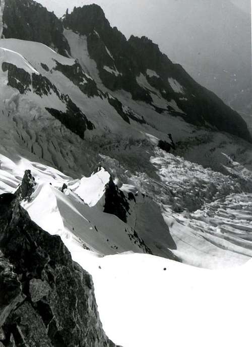
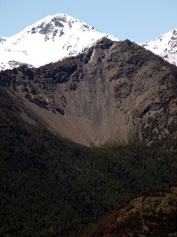
In the Year 2000 since Thursday 13th until Moonday 16th, cause the great flood that struck the whole small Valley of Aosta, occurred an enormous landslide that, departing from a great fault to form of hole from letters, at the Western base of Northern Wall near the rocky "clog" of 
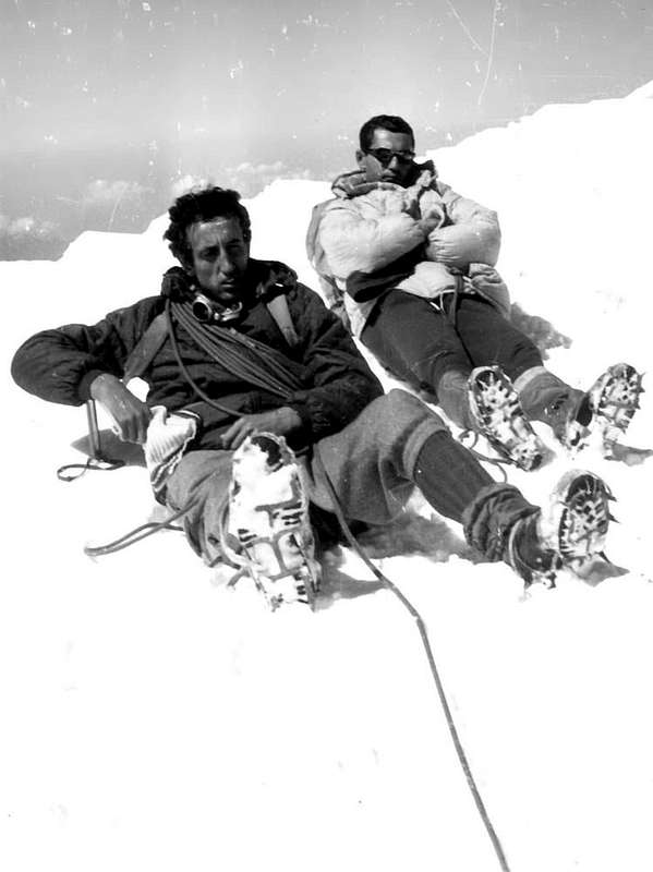
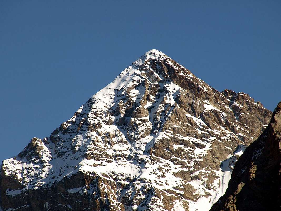
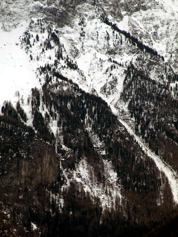
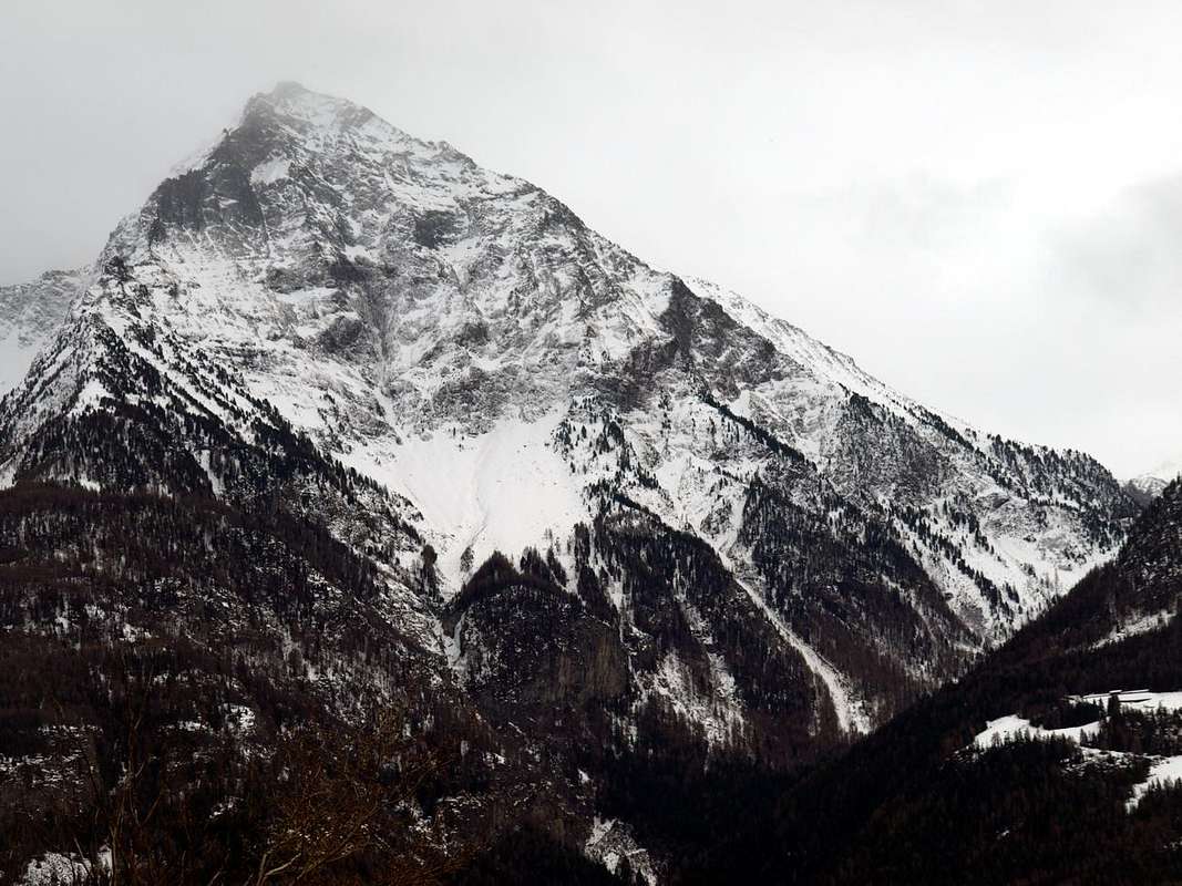
Becca di Nona (3142m, mountain above my village and facing the City of Aosta), wide also 4 metres and long over 250 metres (in July of 1966 she was ascertained by the rope Ilario Antonio Garzotto - Dario Franco Cardellina and Walter Ferronato, that had looked for at first to climb along the right sector of the wall, abdicating then you cause the precariousness of the rock, the presence of such wide earthy crevasse, then from the 20 to the 30 centimeters and along less than about twenty metres). The same descents in the bed of the ancient basal, of Northwest, couloir for over 700 meters with such a blow of double-bladed razor to devastate him completely, widening him than at least ten times and deepening him of almost the same. Then, reached the bed of the Comboé's Torrent inside the narrow and deep Valley of the Dard, it upset the course of it and (formed a knapsack of water with material sundry near the small Bridge of Rongachet 1100 metres about) exploding in the forenoon of the Sunday of October 15 th, 2000, it got wildly epressed on the underlying three Fractions of Saint Bénin, Chenaux and Chèniere, just overlooking the Municipality of Pollein, causing the downfall and the death of seven people of it, among which a child; widening himself to fan also struck the wide Fraction of Pian Felina for then to relieve himself just into the River Dora Baltea.


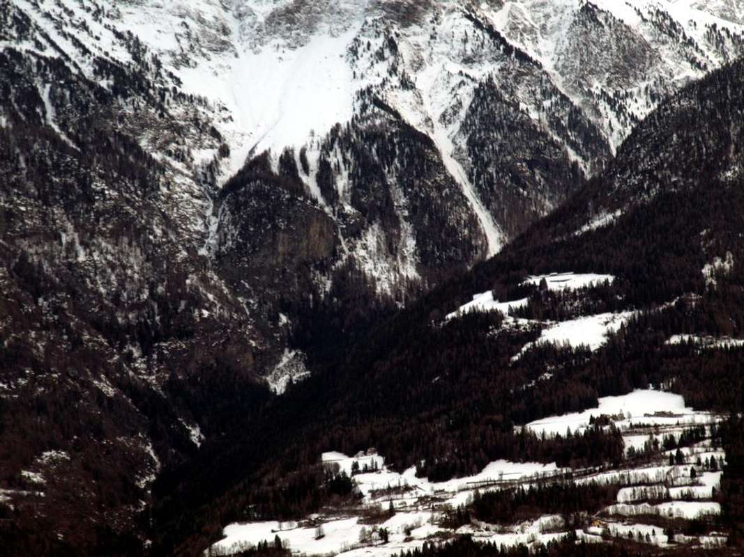
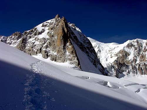
La GRANDE FRANA dell'Alluvione nell'Ottobre del 2000 ai piedi della Becca di Nona.


Nell'Anno 2000 dal giovedì 13 al lunedì 16 Ottobre
, causa la grande alluvione che colpì l'intera piccola Valle d'Aosta, si verificò un'enorme frana che, partendo da una grande faglia a forma di buca da lettere, alla base Occidentale della Parete Nord nelle vicinanze dello zoccolo roccioso della Becca di Nona (3142 m, montagna proprio soprastante il mio paese nonché rivolta alla dirimpettaia Città d'Aosta), larga anche 4 metri e lunga oltre 250 (nel Luglio del 1966 fu constatato dalla cordata Ilario Antonio Garzotto, Dario Franco Cardellina e Walter Ferronato, che dapprima aveva cercato di salire lungo il settore destro della parete, rinunciandovi poi a causa della precarietà della roccia, la presenza di tale crepaccio terroso allora largo dai 20 ai 30 cm. e lungo meno d'una ventina di metri). La stessa scese nel letto dell'antico canale per oltre 750 metri con una doppia rasoiata tale da devastarlo completamente, allargandolo di almeno dieci volte ed approfondendolo di quasi altrettanto. Quindi, raggiunto il letto del Torrente Comboé dentro l'incassato e strettissimo Vallone o Gorgia del Dard (sottostante i Valloni del selvaggio Arbole od Arbole e dell'ameno Comboé), ne sconvolse il corso ed (formata una sacca d'acqua con materiali varii presso il Ponte di Rongachet 1100 metri circa) esplodendo in mattinata di Domenica del 15 Ottobre 2000, si abbatté violentemente sulle Frazioni di Saint Bénin, Chenaux e Chèniere, soprastanti il Comune di Pollein, causandone la rovina e la morte di sette persone, tra le quali un bambino; allargandosi progressivamente a gran ventaglio ventaglio colpì anche la Frazione di Pian Felina per poi scaricarsi nella Dora Baltea.


The GREAT LANDSLIDE of the Flood in October 2000 above the Dard 's Vallon.
An interminable & endless series of events also struck the mountains in the third Millennium, after the great landslides of 1995 and 1997, 2003, 2005 with the collapse of the famous Petit Dru Southwest Pillar (won in solitary between 17 and 22 August 1955 by the equally famous Walter Bonatti) and of 12 September 2011 on the beautiful West Wall of the Petit Dru (3733 m), recorded in the Mont Blanc Chain, already affected by the rocky detachment, not long ago, at the base of the Col Moore (3479m Touring Map, at the beginning of the street with the same name or "Sperone della Brenva") and from the dangerous expanse of seracs on the French side from the "Corridor" to the Mont Blanc. On October 19, 2015 with the fall of a huge boulder at the Mel de la Niva forcing to evacuate the town of Evolène in Switzerland and on September 26, 2018 on the South Face of the Trident du Tacul (3693m). This 2019 season is not exempt, highlighting the collapse of rocky parts almost everywhere in the Valle d'Aosta mountain range, starting from the always present landslide of 
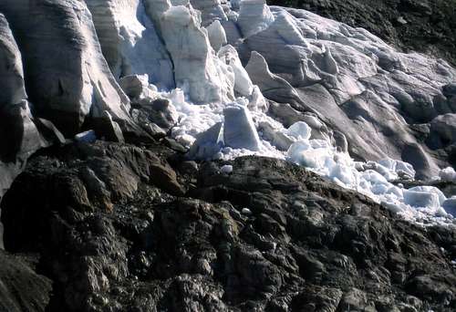
Mont de la Saxe above the Villair and the Eastern most area of ​​Courmayeur to reach the looming detachment of a serac of the Plampincieux Glacier (along the Standard Route at the Southeastern base of the Grandes Jorasses) above the Val Ferret. But starting from the French side starting from the Aiguille du Peigne (3152m) to the various Aiguilles de Chamonix, from the Tour Ronde (3798m, on the Normal Via or route of E-NE Face , in the first days of August (27) 2019 followed a few days later or 3 September 2019 from a second landslide from the nearby Colle Freshfield, about 3650 meters); and again at the Bivouac of Pèriades at the Brèche Puiseux, on August 16 on the Diedro Rébuffat at the Walker Spur at the Grandes Jorasses (4204m), on August 31 on the SE Wall of the Dent du Caiman (3554m) still on the Aiguilles de Chamonix to reach the tops of the far East Monte Rosa (4634m), where on 12 September 2019 at Cima Jagger (3900m) there was a large rocky detachment on its ridge called "Jaggerrucken"; precisely at the altitude of 3000 meters on the buttress dividing the Fillàr Glacier (front at 2725 meters) from that of the Nordend (facing 2540 meters). In addition, several preacautions were taken along the lines of the closure of the SW Ridge or 
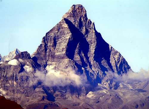
"Cresta del Leone" on the Italian Normal Via of Cervino or Matterhorn (4478m) carried out by the Miss Mayor of Valtournanche on 27 July 2015 and then reopened in feast of the Assumption of the same year, limiting or discouraging certain classic routes such as the "Grand Couloir" at the Aiguille du Goûter (3817m, Touring Map & Vallot) or at the "Arete des Cosmiques" at the Aiguille du Midi (3843m) or in the crossing of the Pointes Lachenal (3622m) at the base of the Mont Blanc du Tacul (Western Top 4249m, East Summit 4247m) for a macroscopic drought. On the other hand, under the Dente del Gigante (4014m), and more precisely at the base of the Aiguilles Marbrées (3536m), between the end of June and the beginning of July 2019 a small lake was born, at about 3320 meters, result of the more than unusual increase in temperature of about 10 degrees centigrade. It is not a good sign, despite registering of a one "birth" ...
La Tour Ronde (3792 m), versante NE
 Becca  Landslide in West by Morion promontory 2016
North Dufour & Nordend from Signalkuppe/Zumstein 1981


Una serie interminabile di eventi hanno colpito anche le montagne nel terzo Millennio, dopo le grandi frane del 1995 e 1997, 2003, 2005 con il crollo fatto registrare alle Aiguilles du Dru (Grand e Petit) del celebre Pilastro Sudovest del Petit Dru (vinto in solitaria tra il 17 ed il 22 Agosto 1955 dall'altrettanto celebre Walter Bonatti) e del 12 Settembre 2011 sulla bella Parete Ovest sempre del Petit Dru (3733 m), registrate nella Catena del Monte Bianco, già colpita, non molto tempo fa, dal distacco roccioso alla base del Col Moore (3479m Carta Touring all'inizio dell'omonima via o "Sperone della Brenva") e dall'altresì perigliosa distesa di seracchi sul versante francese dal "Corridor" al Monte Bianco. Il 19 Ottobre 2015 con caduta di un enorme macigno al Mel de la Niva costringendo ad evacuare l'abitato di Evolène in Svizzera ed il 26 Settembre 2018 sulla Parete Sud del Trident du Tacul (3693 m). Non é esente questa stagione 2019 che ha messo in evidenza crolli di parti rocciose un pò dovunque sulla catena montuosa valdostana, a partire dal sempre franoso Mont de la Saxe sopra il Villair e la zona più Orientale di Courmayeur per arrivare all'incombente distacco di un seracco del Ghiacciaio di Plampincieux (alla base Sudorientale della Grandes Jorasses) sopra la Val Ferret. Ma iniziando dal versante francese partendo dall'Aiguille du Peigne (3152 m) alle Aiguilles de Chamonix, dalla Tour Ronde (sulla Via Normale o Versante E-NE, nei primi giorni di agosto (27) 2019 seguito pochi giorni appresso o 3 Settembre 2019 da una seconda frana dal vicino Colle Freshfield, 3650 metri circa); ed ancora al Bivacco delle Pèriades alla Brèche Puiseux, il 16 Agosto sul Diedro Rébuffat allo Sperone Walker alle Grandes Jorasses, il 31 agosto sulla Parete SE della Dent du Caiman (3554 m) ancora sulle Aiguilles de Chamonix per arrivare alle sommità del lontano ad Oriente Monte Rosa (4634 m), dove il 12 Settembre 2019 alla Cima Jagger (3900 m) si é verificato un grosso distacco roccioso sulla sua cresta chiamata "Jaggerrucken"; precisamente all'altitudine di 3000 metri sul contrafforte divisorio il Ghiacciaio di Fillàr (fronte a 2725 metri) da quello del Nordend (fronte a 2540 metri). Inoltre sono state prese diverse preacauzioni, sulla falsariga della chiusura della Via Normale italiana al Cervino (4478 m) effettuata dal Sindaco di Valtournanche il 27 Luglio 2015 e poi riaperta a Ferragosto dello stesso anno, limitando o sconsigliando alcune vie classiche come al "Grand Couloir" all'Aiguille du Goûter (3817 m, Touring Map & Vallot) od all'"Arete des Cosmiques" all'Aiguille du Midi (3843 m), oppure nella traversata delle Pointes Lachenal (3622 m) alla base del Mont Blanc du Tacul (Vetta Occidentale 4249 m, Cima Orientale 4247 m) per una macroscopica siccità. Per contro, sotto al Dente del Gigante (4014 m), e più precisamente alla base dell'Aiguilles Marbrées (3536 m), tra la fine di giugno e l'inizio di luglio 2019 é nato a quota 3320 metri circa un piccolo lago, frutto del più che insolito aumento della temperatura di circa 10 gradi centigradi. Non é un buon segno, nonostante faccia registrare una "nascita" ...


Comments

No comments posted yet.