Sunrise Stumbles
Trips do not always worked out as planned. However, sometimes changes in plans and unexpected events can make a trip better than anticipated. This was one of those trips…
I woke up early on Saturday morning to pick up a local peakbagging friend, Michael. He was to be the first of several people I would encounter that day for a summit attempt of Lennox Mountain, one of the more prominent yet remote peaks in Washington. However, Michael did not appear at our meet-up location. This seemed odd. Michael acted very interested in participating with this trip beforehand, but he had also asked me to continue without him if he was not at the meet-up location at the designated time. After waiting for a while, I continued driving to Sultan where another person (Fletcher) waited for pickup.
I had first met Fletcher during a successful summit trip of Arrowhead Mountain earlier this year. This would be our second peakbagging trip together. The plan for the Lennox Mountain trip was to approach from the north. Another person who would be with us, Dave, had attempted that route during February of the previous day and came within 300’ elevation of the summit before timing-out. We anticipated the combination of Dave’s direct knowledge of the north approach coupled with an attempt during Spring rather than during Winter (i.e. more daylight) would greatly improve our chances of success.
Fletcher and I arrived shortly after 7:00 AM at the pre-planned group starting point; the furthest Money Creek Road was plowed and/or drivable by a standard vehicle. I immediately noticed potential problems with our approach. During Dave’s attempt the previous year, he was able to drive over three miles to the furthest plowed location and started hiking above 1600’ elevation. However, for this attempt, we would be starting farther away, adding approximately 3-4 miles roundtrip road-snowshoeing and and extra 400’ elevation gain. In addition, during Dave’s attempt the previous year, the crossing of Money Creek was nothing more than a standard creek crossing. However, for this attempt, the crossing of Money Creek appeared to be more like a major river crossing.
Another vehicle arrived ten minutes after we parked. It was Joanna and two of her dogs; we did not expect to see her on this trip because she is generally uncomfortable with crossing creeks. She asked me where Michael was, and I told her that he was not at either meeting/pickup location. She called his brother Josh, who confirmed Michael had left home with the car prior to Josh waking up. Dave and his son Derrick arrived ten minutes later. Dave immediately realized the potential route problems for this attempt. I verified our location using my GPS and we immediately knew we had two choices: Take our chances with the north approach (for which the chances of success seemed less than desirable) or take our chances with a different approach.
Prior to the trip, I had mentioned to several people, including Dave, that some friends had successfully summited Lennox Mountain from the east rather than from the north. The advantages to the other approach were clear: The east approach started just slightly higher (1300’) than where we were currently parked for the north approach (1250’), and the east approach did not require any creek crossings. Dave and I discussed the different approach options for several minutes. It was possible we could try the north approach as planned but be stopped well short of our summit goal by a treacherous crossing of Money Creek, thus wasting enough time and distance to waste any summit goals for the day. It was also possible we could try the east approach and not even reach the trailhead due to snowpack impassable for vehicles. I told Dave it would not require too much extra time for us to at least drive towards the east approach trailhead and see how far the road was drivable, so we all agreed to check out that option.
I led the drive up nearby Miller River Road but soon became concerned. Unlike Money Creek Road, I started seeing subtantial snowpack on the sides of the road by 1000’ elevation. However, Miller River Road itself was surprisingly barren of snowpack. As we continued driving, the mounds of snow on the sides of the road got higher and higher, and the road seemed to become narrower and narrower. However, for whatever bizarre reason, Miller River Road was plowed all the way to the trailhead (1300’ elevation). This seemed bizarre because Miller River Road is a far less popular roadway than Money Creek Road. The snowplow truck had also left enough space for several vehicles to park at the end, even if only because the truck had needed enough extra space to turn around. Parking at a true starting location for an approach, rather than miles away from it, got our group more excited about the prospects of the trip.
![Parking Spot]() Our Convenient Parking Spot
Our Convenient Parking SpotUnexpected Arrivals
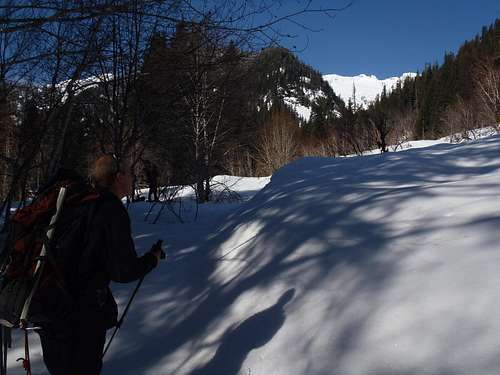
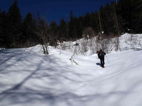
We started snowshoeing up the abandoned West Fork Miller River Road at 8:10 AM. The temperature was cold; the skies above were crystal blue-colored. By 1400’ elevation, we started to notice some cat tracks following the snow-covered road, for which later a bobcat was seen by Dave, Derrick, and Fletcher by 1700’ elevation and ran away. While snowshoeing up the road we eventually found several locations where we could see the Lennox Mountain ridgeline. Our anticipation grew larger.
![Lennox Mountain From Miller River]() First View Of The Goal...
First View Of The Goal...![West Fork Miller River Road]() Following West Fork Miller River Road...
Following West Fork Miller River Road...
After 1.5 hours and nearly three miles, but only a short distance north of Coney Creek, we turned off West Fork Miller River Road and headed up a semi-open snow slope. After several hundred feet of elevation gain, we side-traversed into a forest and soon encountered an old mining road. We followed this road southward towards Coney Creek, but despite heading the correct general direction the road oddly went downhill (because we did not realize the road switchbacked uphill a short distance behind where we had joined the road). Before reaching Coney Creek, we turned west and headed steeply uphill through the thick forest. We soon encountered the mining road again, which we followed (or sometimes paralleled) for a while until reaching a large basin (2750’ elevation) at 10:45 AM.
![Ascending Near Coney Creek]() Following Old Mining Road Route Near Coney Creek...
Following Old Mining Road Route Near Coney Creek...![Coney Basin]() Entering Large Basin
Entering Large Basin
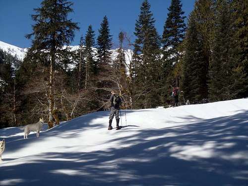
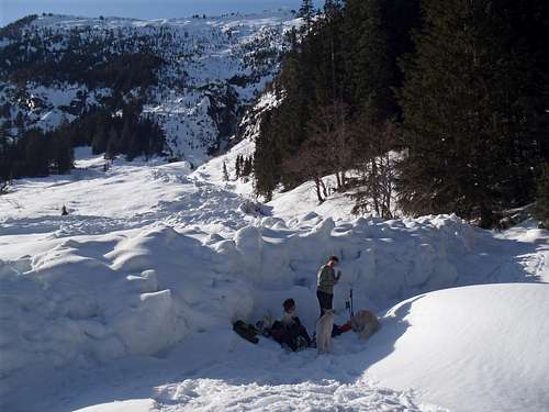
Lennox Mountain was visible above the right side of the basin, but the most notable aspect of the basin was the amount of avalanche debris sitting in it. Remnants of a major avalanche had left behind a substantial track of debris and a large snow wall at the base of the basin. We were each very thankful the avalanche had occurred some other day prior to our visit. After a 15 minute break, rather than ascend the open basin and possibly get cliffed-out or encounter avalanche-prone slopes, we began steeply ascending northwest up a forested ridgeline. This forested ridge was very steep, gaining approximately 2400’ elevation in one mile. The travel was slow but steady, with Derrick and Fletcher leading the way.
![Ascending Steep Slopes]() Ascending Steep Forested Slopes
Ascending Steep Forested Slopes
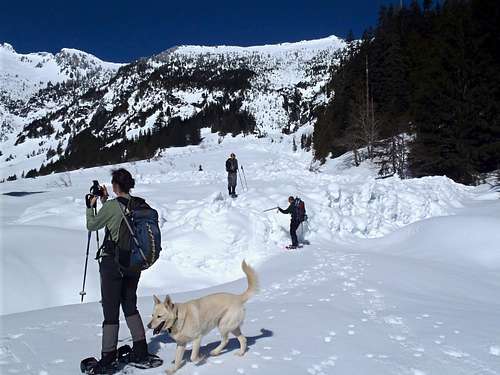
Dave and Joanna took a short snack break at 4100’ elevation but I continued following the snow tracks left by Derrick and Fletcher. As soon as I was approximately 100’ above Joanna I heard her shout, “Oh my gosh! It’s Michael!” I looked down the forested slopes and could see a silhouette of a person ascending the ridge towards Dave and Joanna. We would later learn that Michael had woken up late, driven himself to Money Creek Road, did not find any vehicles so he figured we tried a different approach, and eventually found our parking spot. What was even more impressive than finding our parking spot was that he started snowshoeing our route nearly 1.5 hours after we did. He was very fast!
The East Ridge Cometh
The forest opened up above 4500’ elevation. Derrick and Fletcher decided to stop at a small grove of trees near the top of the steep slope (5200’ elevation). I reached their location 10 minutes afterwards at 1:15 PM, and then Dave, Joanna, and Michael arrived 10-15 minutes later. Frozen-over/snow-covered Coney Lake was around the corner of the ridge from our location, just beyond our sight, and the wind was very breezy and frigid.
![Views Opening Up]() Southeast Views At 5000' Elevation...
Southeast Views At 5000' Elevation...![Rest Stop]() Rest Stop At 5200' Elevation
Rest Stop At 5200' Elevation
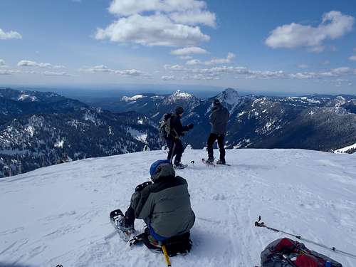
Soon after the group rejoined, Derrick and Fletcher headed west to what we hoped would be the summit but what was actually the false summit (5695’). Joanna and her dogs were a short distance behind them, and then followed by Dave and I, and eventually Michael (who was very tired by this stage) continued. Before reaching the false summit, the true summit was in clear view… less than 200’ of vertical gain remaining but still 0.3 miles away.
![East Ridge]() East Ridgeline Of Lennox Mountain
East Ridgeline Of Lennox Mountain![Lennox False Summit]() Looking Back At Dave Standing Near False Summit
Looking Back At Dave Standing Near False Summit
Joanna grew concerned of the prospect of taking her dogs across several narrow, and possibly corniced, sections of the summit ridge. As a result, she stopped near the false summit while everyone else continued. There is no faulting her decision; I would rather a person stop short of a summit out of concern for safety than to uncomfortably continue. Derrick and Fletcher reached the summit (5894') first, followed shortly thereafter by Dave and I.
![Following Ridge To Lennox Summit]() Following Upper Ridgeline To True Summit...
Following Upper Ridgeline To True Summit...![Lennox Mountain Summit Ascent]() Derrick and Fletcher Reach The Summit
Derrick and Fletcher Reach The Summit
It had taken our group 6h30m to reach the summit from the cars. Michael arrived 10 minutes later, exhausted and rightly so... it had taken him only five hours to reach the summit. The five of us took one group summit photo before the group started to descen. The wind was even more breezy and frigid than it was earlier, and everyone was feeling the effects of the cold. Dave, Derrick, and Fletcher headed back while I waited on the summit with Michael for a few more minutes. Michael had used so much energy and effort to get to the summit I thought he deserved some company and time to enjoy it.
![North Fork From Lennox Summit]() Looking West From Summit...
Looking West From Summit...![Summit Group Photo]() Group Photo At Summit
Group Photo At Summit
The summit views were spectacular, some of the best I have ever seen in the Alpine Lakes Wilderness. We could see mountains in every direction. Some snow slopes looked like white-colored pillows. Some ridges had large cornices. Some peaks closer to the Cascade Crest were covered by clouds. Fortunately, the weather and snow conditions on Lennox Mountain were much better than would be normally expected during most April months in Washington. Michael and I began descending from the summit at 3:00 PM.
![Snow Pillows]() Snow Pillows
Snow Pillows![Goat Mountain From Lennox]() Looking Southwest Towards Goat Mountain...
Looking Southwest Towards Goat Mountain...A Daunting Descent and Final Thoughts
While the rest of the group decided to return to the previous rest stop at 5200’ elevation, which required an additional steep ascent, Michael and I did not want an additional ascending so we chose to side-traverse around that particular hill and easily reached our original tracks below it at 5000’ elevation. After the group rejoined, we took a short snack break before continuing down the steep forest slopes. We were hoping that the descent of the steep ridge would be much faster than the ascent had been, but the reality was that some sections were so steep that it required extra caution and time to avoid accidents such as tree wells and sliding. The steep ridge originally took the majority of our group 2h15m to ascend but took 1h30m to descend, much less difference than we had hoped.
![Avalanche Debris]() Final Look At Basin and Avalanche Debris
Final Look At Basin and Avalanche Debris
The rest of the descent from the basin to the cars was uneventful. Michael was exhausted, so Joanna and I went back with him while the rest of the group continued ahead of us. Even with extra breaks and a slower pace, Dave, Derrick, and Fletcher arrived at the cars only 15 minutes ahead of us. We were back during daylight and were all safe. We were each tired from the long trip but we all believed the effort was worthwhile. After changing our clothes and packing our gear, we each said our good-byes and went our separate ways. I gave Michael my emergency-stashed “Five Hour Energy” drink in an attempt to help him drive home more awake. He was able to drive home without incident.
Having now done a successful summit approach of Lennox Mountain from the east, I cannot fathom why people attempt the north approach. The north approach involves crossing Money Creek (which we discovered during this day could be very troublesome and potentially dangerous to cross), while the east approach does not involve any creek crossing. In addition, Dave informed me that the north approach would have involved some bushwhacking through annoying slide alder despite the deep snowpack, while in contrast the east approach had no brush problems because of the deep snowpack.
The east approach might be a long trek, but as a Spring ascent it is a much more straightforward and safe summit route for Lennox Mountain than the north approach. Even if Miller River Road had not been plowed, it would have only added another 1-2 hours to the trip. In that scenario, even including our late (post-sunrise) start on this day, we still would have been safely back on the main road before darkness would have set in.
Overall, it took us approximately 11h30m roundtrip to travel 12 miles and have over 5000' cumulative elevation gain. As a Spring ascent while local avalanche conditions are low-to-moderate, as they were on this day, the east approach for Lennox Mountain proved to be an excellent route option and is highly recommended. I hope future summit teams who choose this route will be as successful and have as great a trip as we did on this day.


Comments
Post a Comment