
-
 4933 Hits
-
 0% Score
-
 0 Votes
|
|
Route |
|---|---|
|
|
69.57820°N / 19.37929°E |
|
|
Ski tour or hike. |
|
|
Half a day |
|
|
scramble |
|
|
Approach

 |
Route Description
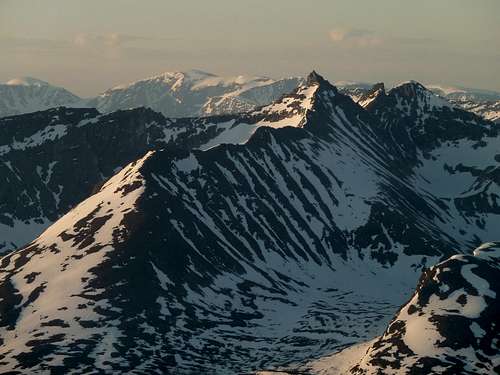
Many summits visible from Tromsdalstind.Hamperokken in the center foreground. The entire middagsaksle ridge route is visible. It's the long ridge split in sun\shade.The skyline in the back shows part of the Jiekkevarre traverse. Look from the summit of Hamperokken, behind and just to the left of the summit pinnacle is Holmbuktind. One can see the top of the skiing route. Follow the ramp of snow to the pass, and take a sharp right to get to the summit. From there, continue left to Jiekkevarre, the highest dome. Continue looking left to the gap and onward to Kveita, which is the next dome of snow on the far left edge of the picture.Also in this photo, in the foreground to the left of Hamperokken is Gabrielfjellet, which is an extension of Hamperokken, but can be considered a separate peak.The peak immediately to the right of Hamperokken is Bjørnskardalstind (trans. Bear Pass Valley Peak.)
From the highway, begin a gentle diagonal away from the stream and toward the ridge. From this point, the route appears to climb a face before connecting to a gentle ridge slanting up and right. This is an illusion. After around 30-45 minutes of gradual traversing left, the climber breaks out ot the scrub birch above all vegetation. Depending on the time of year, and snow cover, the climber must choose the best route of ascent. For the most part, staying slightly left will be the best, though too far, and the terrain gets uneven and rocky.
At 900 meters, the route eases to an ascending plateau. Traverse up and right (south) along this plateau, ignoring what appears to be the summit to the left. At just over 1200 meters the ridge crest is gained, and can be traversed a short distance to a high point. From here, the ski route ends, and a glorious descent begins.
Continuation: WARNING: the following information is just from observations, I don't know anyone who has actually climbed the rest of the ridge:
From the skiers high point, a short easy descent of about 15 meters reaches the connecting ridge. Following this will involve some 3rd class traversing, though sections of the ridge are wide and almost perfectly flat. When coming to the summit spire of Hamperokken, a traverse would be easiest made to the right (west) across the north face. Good snow and ice is critical here as it's steep and loose, probably around 60 degrees. Following the traverse, the standard route is reached for the summit.
Here is a link showing the entire route in photo's, description in Norwegian: Photo series
 |
Essential Gear
Winter/Spring: Randonee or telemark ski equipment.Summer/Fall: Boots and good trekking poles. It's surprising how exciting steep wet heather can be at times.