
-
 2945 Hits
-
 77.48% Score
-
 8 Votes
|
|
Route |
|---|---|
|
|
46.53407°N / 11.08559°E |
|
|
Hiking |
|
|
Summer, Fall |
|
|
Half a day |
|
|
Steep Hike and Scramble |
|
|
Overview
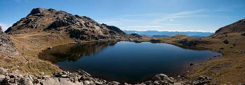 Kleine Laugenspitze mirrored in Laugensee Kleine Laugenspitze mirrored in Laugensee |
The most direct route to Große Laugenspitze / Monte Luco is a very steep scramble from Gampenpass / Passo Palade. It is rarely climbed, mainly due to the fact that an easier route runs close nearby. For the first half it uses Sentiero Alberto Bonacossa a 54 trekking route between the pass and the mountain town of Rabbi in the south of the Ortler / Ortles Group. Bonacossa was a famous Italian sportsman (president of the national Italian tennis association) for whom more than one mountain route has been named. The best known one is a ferrata / sentiero attrezzato in the Cadini di Misurina.
Only the very first 300m of the route run along a narrow mountain road, after which Sentiero Bonacossa dives into a very dark forest of fir and pine trees. The slope is about 30° for 3km until you get close to the picturesque Laugensee. The final ascent through the east facce is about 45° until you reach the final chimney right underneath the main summit of the mountain.
Getting There
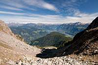
 Looking across the Etsch / Adige Valley towards the Sarntal Alps right above the timberline
Most routes to Laugenspitze start at Gampenpass / Passo Palade opposite to the restaurant on the pass. The Laugenspitze main page gives instructions how to reach this road pass.
Route Description
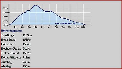 Route Statistics (East face route is the ascending line to the left
- Start altitude: 1550m
- Summit altitude: 2434m
- Prevailing exposure: East
- Type: Steep Hike and Scramble
- Protection: None
From the parking lot near the Gampenpass / Passo Palade Restaurant cross the road to the start of a narrow mountain road. Follow this road in a wide swing for something like 300m until you reach the start of Sentiero Bonacossa. The trail plunges into the very dense and dark forest and immediately starts to ascend very steeply through the trees. For the next 2km / 600m of elevation you rarely get a glimpse of your surroundings as the trail climbs at a constant angle of roughly 30°.
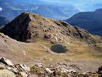
 The Brenta Group
After roughly 90 minutes you head out of the forest and now climb across open pastures, still at the same angle. Your position is east of Kleine Laugenspitze, the smallest of the three summits. In order to reach the Laugenspitze cirque with its lake you need to pass Kleine Laugenspitze on its southern side, where a first glimpse of the final destination and the two routes which head for it from this side can be seen. To the left is the normal south-west ridge route, to the right the east face route, which heads for the north ridge, never quite reaching it, however.
 |  |  |
Passing Kleine Laugenspitze first views of the Brenta Group develop and a steep rocky hike finally takes you to Laugensee inside the cirque which is formed by the three summits of our mountain. Make sure to step a bit sideways (northward) into the saddle between Kleine and Mittlere Laugenspitze from where a wonderful view of the mountains to the north awaits you.
 Große and Mittlere Laugenspitze
Pass to the far (western) side of the lake, where the final scramble through the south face of Große Laugenspitze starts. The angle of the slope is more than 50° but the zig-zagging trail stays at an angle of about 45°. In several sections difficulty rises to UIAA I but overall the route remains relatively easy. The trail heads for a nothch on the north ridge which separates Große and Mittlere Laugenspitze but before it reaches it, it turns left (south) to head for a short wide chimney immediately to the east of the main summit. A last UIAA I struggle takes you to the summit of Große Laugenspitze.