
-
 4163 Hits
-
 79.04% Score
-
 10 Votes
|
|
Route |
|---|---|
|
|
46.53407°N / 11.08559°E |
|
|
Hiking |
|
|
Summer, Fall |
|
|
Half a day |
|
|
Hike |
|
|
Overview
 Laugenspitze South Summit Laugenspitze South Summit |
Of the many routes which lead to Große Laugenspitze / Monte Luco the South Ridge Route from Gampenpass is one of the longest but also one of the easiest. Its first two fifth lead along a dirt road, which serves the Laugenalm Pasture to the south-east of the mountain while the remainder runs along easy hiking trails. It runs along three fifth of the normal route to the mountain, which rather traverses the steep and exposed south-east ridge.
Therefore those last two fifth, which differ from the normal route can be rather solitary. A lonesome traverse underneath the southern east face leads to the panoramic south ridge where several of the longer trails from Ultental / Val d'Ultimo and Hofmahdjoch join. The final section of the south ridge is almost flat and offers fabulous views all along.
Getting There
 Ultener Hochwart as seen from the steepest section of the south ridge route
Most routes to Laugenspitze start at Gampenpass / Passo Palade opposite to the restaurant on the pass. The Laugenspitze main page gives instructions how to reach this road pass.
Route Description
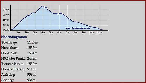 Route Statistics (South ridge is the descending part to the right
- Start altitude: 1550m
- Summit altitude: 2434m
- Prevailing exposure: Eastand South
- Type: Hike
nbsp; - Protection: None
From the restaurant at Gampenpass / Passo Palade cross the road and follow the mountain / dirt road which heads to Laugenalm. After several hundred metres Sentiero Bonacossa turns of to the right. Remain on the road which heads in south-westerly direction. After a while the firts turns appear and the road turns steeper until it heads above the forest canopy near the pasture / rustic restaurant of Laugenalm.
 |  |  |
From here trail number 10 heads up a steep valley towards the cirque between the three summits of the mountain. The normal route turns off right, climbing a steep step in the terrain while our south ridge route turns south-west onto trail number 133 (Sentiero Bonacossa). A short scramble takes you to the south-east face traverse which heads for a point low on the south ridge of the mountain. In spring you can find a multitude of beautiful flowers on the meadows which are crossed by this traverse.
 |  |  |
Once on the south ridge things get a bit more complicated. There are several paths which are hard to distinguish from each other but which eventually all lead to the summit of Große Laugenspitze / Monte Luco. Moreover one trail from Hofmahdjoch joins as well as one from Ultental / Val d'Ultimo making matters even more confusing. The regular trail runs along to the west of the south ridge but there also is a direct path which on the final ascent gets a bit tricky and exposed. A short UIAA II section needs to be climbed before you reach the broad top of the southernmost summit of Laugenspitze. From there a rather obvious ridge traverse leads to the main summit without any gain of elevation.