
-
 2307 Hits
-
 77.48% Score
-
 8 Votes
|
|
Route |
|---|---|
|
|
46.73452°N / 11.39553°E |
|
|
Download GPX » View Route on Map |
|
|
Hiking, Scrambling |
|
|
Summer, Fall |
|
|
Most of a day |
|
|
Hike and exposed scramble |
|
|
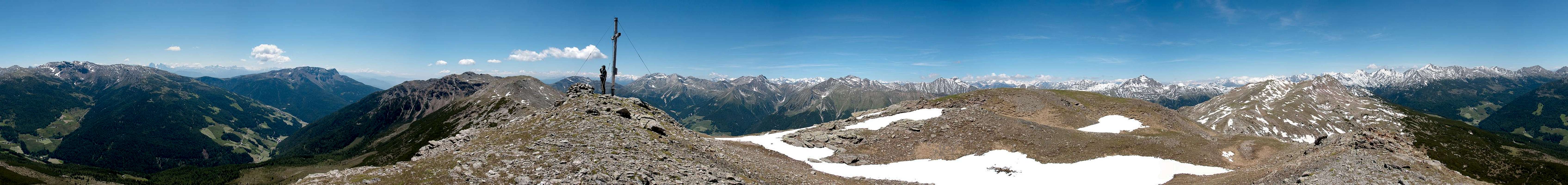
Overview
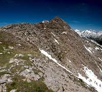
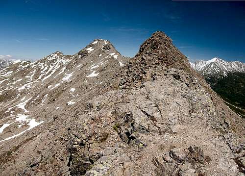 Rocky section between Karnspitz and Hoferberg Rocky section between Karnspitz and Hoferberg |
Gentersbergkamm / Cresta Ganda is a ridge of about 2400m in height, which protrudes from the north-eastern side of the Sarntal Alps horseshoe into the centre of the range. It is a very panoramic ridge but thanks to big elevation differences only few hikers attempt it. Moreover, the two possible trailheads are somewhat remote and take long access times if you don't happen to stay in the broader vicinity of the ridge.
  |
This route describes the north-eastern half of the ridge as climbed from Durnholz / Valdurna. The complete traverse takes a very long day and depends on reaching the last bus between Astfeld / Campolasta and Durnholz / Valdurna. If you miss that the day will get even longer. We decided to return after the fourth summit, Hurlerspitze / Monte Corlo, which turned our hike in a long daytour as well.
Getting There
 Durnholz and Durnholzer See
There are three reasonable trailheads for the ridge traverse, one at Durnholz / Valdurna one in Pens / Penes, one in Astfeld / Campolasta, all three in Sarntal / Val Sarentino. This page describes the traverse started at Durnholz / Valdurna.
- Durnholz / Valdurna trailhead
- Take Brenner Motorway A22 to Bozen / Bolzano
- Drive through the city, following signs to Sarntal / Val Sarentino on SS508
- At Astfeld / Campolasta turn off onto SP137, direction Durnholz / Valdurna. You have to park outside the village and will be charged a fee of 3€.
Route Description
 |
- Start altitude: 1500m
- Summit altitude: 2450m
- Prevailing exposure: SE and NW
- Type: Hike and scramble
nbsp; - Protection: None
Durnholz / Valdurna to Durnholzer Jöchl
From the parking lot at the lower end of Durnholz / Valdurna (parking fee: 3€) follow the road for several hundred metres until you reach the shore of Durnholzer see / Lago di Valdurna. The road follows the shore for a few hundred metres and than switches back and up into the village, but there is a shortcutting path, which scales a staircase, then runs through a few smaller side streets until you reach the main street near the biggest inn of the place. Here the only challenge in orientation awaited us: where to head onwards? In the end it turned out that you have to simply hike straight ahead but with construction going on it was difficult to find.
 |  |  |
You now start hiking very steeply across the meadows of the village, heading for a farmhouse which you can see to the left. At the farmhouse the path joins a dirt road through the farmyard and soon afterwards enters a dense forest turning into a path again. Going remains steep, in one place the ground has broken away you have to negotiate the brittle slopes before returning to the path.
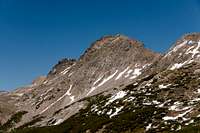
 Sarner Weißhorn from Durnholzer Jöchl
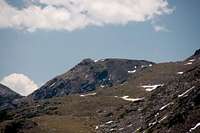
After about an hour you reach a small mountain pasture, above which the big trees vanish. Rather, the ground is covered by numerous dwarf pines, just high enough to obstruct views but low enough to have you out in the open sun. The endpoint of the first stage becomes visible: Durnholzer Jöchl is up ahead with the Gentersbergkamm Ridge also visible in foreshortened view. Make sure you head for the saddle, though the traverse avoids it: a wonderful view of Sarner Weißhorn / Corno Bianco di Penes across Penser Tal / Val di Penes awaits you. (On the other hand, tthis mountain will accompany you for the rest of the day ...)
Karnspitz / Cima di Quaire
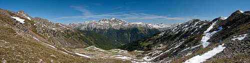
Return to the Durnholz / Valdurna side of the saddle where a path awaits you which passes a small hill and then heads for the base of Karnspitz / Cima di Quaire. You have to pass a small valley (snow possible in June). At the base a WW II position awaits you. In the snow conditions we encountered we had to walk right through the ruins of the building to reach the path to Karnspitz - in dry conditions there might be a way around them.
 |  |  |
Follow the trench and a few steps to the north-east ridge of the mountain, which the path follows for most of the time. The ridge is steep and the rock quality worse than horrible. The path winds along the ridge until right underneath the summit, where it turns to the north face, the slope of which it follows to the summit.
Hoferberg
The next mountain, twin peaked Hoferberg is right ahead. This mountain is the highest one on the ridge and the traverse between Kanspitz and Hoferberg is the most exposed part of the traverse. From the Karnspitz summit turn south-west and head into a small gully, which ends out on the south-west ridge of the mountain. Again, we had snow here, so that we had to use a parallel gully and return to the ridge in a rocky section. Rock quality is still horrible and you have to negotiate your way around a broad gendarme before reaching the saddle between the mountains.
 | 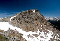 |  |
Out of the saddle a short steep ascent takes you to the Hoferberg north-east ridge, which is surprisingly broad. After a flat section you reach the base of a first summit which turns out to be a broad camelback. A few steps down to a saddle and some more steps up and you stand on the main Hoferberg summit enjoying the views around. Again several metres down and you are in a saddle between the two Hoferberg summits, with a wonderful view of the main summit south face. Again a steep ascent awaits you and you stand on the secondary summit.
Gentersbergspitze / Monte dei Masi
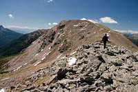
The following section amounts to something of an anticlimax. After the rather steep sections of Karnspitz and Hoferberg the descent from the latter is already surprisingly lame. After a short rocky section near the second summit you simply follow the broad ridge down into a slightly pronounced saddle. The following Gentersbergspitze / Monte dei Masi consists of several (3 or 4) summits, all of which have similar elevations and thus turn the mountain into a kind of plateau. The path leads onward to the highest summit the views of which are comparable to the ones from the mountains before.
 |  |  |
Hurlerspitze / Monte Corlo
A broad back separates Gentersbergspitze / Monte dei Masi from Hurlerspitze / Monte Corlo. You have to descend into a small valley off the main ridge which, however, opens out into the saddle between the two mountains. From there a little rock hopping takes you across an unnamed secondary summit onto the north ridge of Hurlerspitze. An easy traverse and you are on the summit.
 |  |  |
The following section to Kollmannspitze / Monte Colma runs along the same type of difficulty only afterwards you have to negotiate a profound saddle and exposed protected sections towards the summit of Radlspitze / Cima Rodella.