Stats
- Route: Ferguson Canyon, W Ridge
- Elevation Gained: 4,324 ft
- Distance: 3.5 miles (7.3 miles RT)
- RT Time: 4 hrs 55min (strenuous)
- Trailhead: Ferguson Canyon
- TH Elevation: 5,250'
- Summit Elev.: 9,524'
- Rating: II Class 3-
- Climbers: Mark Thomas
|
![]() |
Ascent Route: Ferguson Canyon – West Ridge
Descent Route: unnamed ‘poop chute’ – Ferguson Canyon
Storm Mountain was another major Wasatch peak that I had wanted to do for a while, and on Sunday, June 6th, I set out to bag it. I couldn’t find anyone else interested in climbing it, so I set out alone, leaving my car at 8am. Typical of most Wasatch western approaches, I started out in a Salt Lake City suburb, but quickly found myself isolated from the city. The trail began as a dirt road before fading into a series of branching and merging trails, all of which headed up the narrow mouth of Ferguson canyon. There are many striated granite cliffs here which are very popular for rock climbing, but this morning I was the only one in the canyon. The trail had started out very flat, the switchbacks to come were very flat, and the upper meadow was relatively flat, so most of the elevation gain was isolated into a few steep straight-a-ways on the trail, making it steeper than the average elevation gain would lead one to believe.
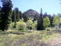
![June 6th 2004 - The summit of...]() First view of Storm Mountain's summit
First view of Storm Mountain's summit
The trail was hard to follow since there were so many other use-trails in the area, and the stream, full from spring runoff, filled in much of the main trail. I persisted, walking up a swamped trail, crossing rocks to the north side of the stream, to avoid some cliffs dropping directly into the stream. From there I hiked straight up a very steep hill, missed the next crossing, but forded the stream on some bushes and rocks a little ways farther up the canyon. I crossed to the north side of the stream again on a log and took my first 3 minute break. I was resolved to rest for three minutes every half hour, and it was now 8:30 am. A few minutes after my first break I encountered the switchbacks. These were very flat and I made good time on them. I paid special care to avoid taking the branch to the lookout and found the switchback that continued up the canyon from the more commonly traveled trail. From here the trail became even more overgrown and never got much better - apparently not many people continue up Ferguson Canyon to hike Storm Mountain. After the final switchback I entered a meadow with a nice view of the surrounding canyon, which had begun to broaden as I ascended higher. There were still many scattered cliffs high above me on the ridgelines.
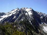
![June 6th 2004 - The ridgeline...]() Robinson Ridge seen from the summit
Robinson Ridge seen from the summit
As I hiked on I kept hearing popping sounds that I attributed to some construction project going on in the suburbs below – now that I had line-of-site with the city I could begin to hear some of its sounds. I crossed the river to the south, and then to the north again. At one point I entered a clearing and some bushes ahead of me shook intensely and out fluttered a pheasant. I took a few minutes to snap some photos of it and let myself be amused by its silly clucking before continuing on.
![June 6th 2004 - Wildcat Ridge...]() Wildcat Ridge seen from the summit
Wildcat Ridge seen from the summit
I crossed the river to the south again and began to wind up along the north edge of a steep meadow. As I neared the cliffs above me the faint trail began to ease up on the abuse that the low branches were wreaking on my legs and I entered a dry stream bed. The trail continued straight up the steep stream bed with occasional detours onto the upper sides of the ditch before eventually topping out in a flat meadow above the cliffs on the south side of the canyon. From here I had my first glimpse of the cirque. It was close now and I knew that I would be at the base of the peak in a matter of minutes. I walked to a joining meadow to the south before cutting through some pine trees and aspens to another meadow to the north. From here I continued cross country on a series of linked meadows along the base of the north slopes of the canyon. Occasionally I followed a faint use trail, but it disappeared often. While the standard route up the peak was to follow the meadows to the end of the cirque and scramble south on the ridge to the peak, I decided to take the alternate route listed by John Veranth in his “Hiking the Wasatch” trail guide, which ascends the west ridge of the peak, on the north side of the canyon.
![June 6th 2004 - Mount Olympus...]() Mt. Olympus seen from the summit
Mt. Olympus seen from the summit
As I neared the base of the peak, keeping close to the north side of the meadows, I saw a twisting chute gouged out of the rocky ridge. It has a lone tall pine tree in it and it appeared to be a good way to access the ridge with a minimum amount of light bush-wacking. The quartzite rocks in the chute were a little loose, but not too bad. Once I got above the pine tree I traversed west on some ledges to gain the ridge. From here it was a nice scramble to the summit. It was mostly class 2 with a few 15-25 ft class 3 walls, and there was only a little bit of brush that was in the way. There was never much exposure, but the views were incredible. I could hear popping sounds again and this time I realized that it was not hammering at a construction site, but rather, gun shots. I could see a shooting range on a plateau above the mouth of Big Cottonwood canyon 4,000 feet below me.
I reached the summit at 10:30am and was surprised to find another summit register – I had only seen registers on a few other Wasatch peaks. It turned out to be a geocache. These are registers left at hidden locations around the US as part of a nationwide treasure hunt – people would load geocache coordinates from a website into a GPS unit and would hunt for them. The caches contained a register and some odd items – people who found the caches were encouraged to take something from the cache and leave something behind. Inside the cache was a business card, a membership ID, a plastic Chihuahua form a fast food chain, some currency with Cyrillic writing on it (perhaps its Russian?), and a skier figure made out of soldered screws, a wing-nut, and other metal items. I called my father from the summit on my cell phone, wrote in the register, had a snack, and took some of the coins from the register. I didn’t have much to give back, but I left 3 granola bars with my summit date attached for the next discoverers to eat.
I had originally planned to do the mountaineering traverse along a narrow ridge and over several unnamed peaks to reach the Broad Fork Twin Peaks, but the snow was so sloppy that I decided to leave the route for when the snow had fully melted or the following spring. I left the summit at 11:20am and headed down the standard route, following a ridge heading south to a low point in the cirque headwall. I became fed up with the vegetation very quickly. Luckily I spotted a chute below me that seemed to go all the way down to the meadow, and I headed down it. The chute had a lot of loose rock, but it still seemed a more pleasant descent alternative for me. As I reached the meadow I met a party of 5 people heading up the meadow. They didn’t seem interested in doing the cleaner west ridge, so I gave them directions to the start of the standard route and continued down the trail.
I descended at a fast pace, jogging at some points, moving my legs as fast as possible to keep up with all of the rocks and tree roots racing underneath me. I sped past the groups of climbers who had since descended on the climbing areas at the mouth of the canyon and reached my car at 12:55 pm.
Links
Comments
No comments posted yet.