
|
|
Mountain/Rock |
|---|---|
|
|
38.22820°N / 111.1994°W |
|
|
Wayne |
|
|
Hiking |
|
|
Spring, Summer, Fall, Winter |
|
|
7289 ft / 2222 m |
|
|
 Golden Throne
Overview
Capitol Reef National Park is a beautiful and amazing place, full of surprises and geologic wonders. Home to the Waterpocket Fold and so much more to visit, and so it is not at all surprising that few know of this peak that is higher than the nearby Golden Throne. Not touted at all, this peak is very much unknown and would appeal to the few that can appreciate a good cross country hike, a bit of a scramble and a superb viewpoint while spending time in this outstanding National Park. The nearby dome called the Golden Throne is the "famous" landmark of the area but when you reach the summit of George BM peak, you find yourself looking down towards it. George BM's summit as seen from the bench area below
The BM in the name George BM signifies that a benchmark placed by the USGS survey teams was placed at the summit but where the name George came from and who it honors is not known by the author of this page at this present time. Two witness benchmarks are also located near the central one although you will have to look for them since they are located in interesting spots. I know of one reference to this one as George Dome but have not seen that name anywhere else. On the topo map it is called George BM.
On the Utah prominence list, this one comes in well down the list at #196 with but 1309 feet of prominence but the view obtained from getting to the top of this special peak is one of the best anywhere.
UPDATE: A great picasa album has been provided by NWHiker member Albert.
Getting There
From Torrey or Hanksville, drive on highway 24 to the visitor center in Fruita and then turn south towards the campground which you will pass on the way. Drive 7.8 miles to the turnoff for Capitol Wash road, which passes a parking area and has restroom facilities and the road you want passes a usually open gate (closed during flash flood possibilities) and enters onto a dirt road which is a 2.2 miles drive to the trailhead and end of the road. High clearance isn't necessary on this well graded dirt road. So follow the dirt road into Capitol Wash to the very end and park at the trailhead for the Golden Throne hiking trail. A covered picnic table area is available as well as a restroom (vault toilet). Look for the sign marking the Golden Throne trail and this is where you will begin your hike from.At one time, Capitol Gorge was the only route through this portion of Capitol Reef but that all changed in 1964 when Utah Hwy 24 was built. Early settlers and travelers made their way through this narrow passage, avoiding it during times of potential flash flooding which made it a dangerous place and many have left their names on the canyon walls as noted below:
Fodor's Review:
Travelers passing through Capitol Gorge in the 19th and early 20th centuries etched the canyon wall with their names and the date they passed. Directly across the canyon from the Pioneer Register and about 50 feet up are signatures etched into the canyon wall by an early United States Geologic Survey crew. It's illegal to write or scratch on the canyon walls today. You can reach the register via an easy 1-mi hike from the end of the road.
See this link for a picture.
Red Tape
Located in Capitol Reef National Park, it is important to understand and follow the park regulations.Write to
Capitol Reef National Park
HC 70 Box 15
Torrey, UT 84775
E-mail Us
Phone
Visitor Information
(435) 425-3791 ext. 111
Fax
(435) 425-3026
Camping
A nice campground is available at Fruita, complete with running water and modern bathrooms (flush toilets). Weekends can be crowded in the summer season so be aware of the first come first serve aspect, reservations are not possible. (hopefully it will remain that way)Link One
Link two
 Campground near park headquarters and close to Capitol Gorge
 Near park headquarters at Fruita
Weather

Route
The following description represents the route we used and there may be a better way to get to the top of this peak. If you choose to utilize this route as described here, you do so at your own risk (my disclaimer). Trailhead sign
 Trailhead in Capitol Gorge
Using this route, it was a round trip of 9 miles with around 2000 feet of elevation gain. Four of the miles were on the very well designed Golden Throne trail and the other five were cross country following use trails and common sense (GPS waypoints)
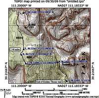
Follow the Golden Throne trail to its end and then look for a use trail that starts just before you gain the last bit of elevation up to the view point. (see the map that is posted in this section) You are off trail if you have to step on crytobiotic soil, the use trail is there, but requires sleuthing for it at the beginning.
The use trail takes you toward the Golden Throne (below it of course) to a spot where you will see a large tank at the head of the canyon which ends (natural water pool - see pic) below you and when you see that landmark, the way you want to go is behind it and then to the left of it (waypoint B), heading up on a highway of slickrock, marked with cairns along the way. Staying left of the rock structures (see this pic), work your way into a wash and follow the wash. This will keep you off of cryptobiotic soil and also help you avoid the nasty cacti which will plague you when you have to deal with it. (see pic) At a confluence of two washes (waypoint D), take the smaller fork to the right and follow its winding path to as close to George BM as you can. Look for a cleft and head for it (see pic). From there you will make your way up toward waypoint F and the base of the class 3 section that is the crux of the hike. Once above the wall there is a flat area that works nicely over to a gully that will lead up to close to the summit of George BM.
 Our route
Cryptobiotic soil
This is an important consideration and Wikipedia has some good informationon this topic. I have included some of that information here:
"In more arid regions, vegetative cover is generally sparse. Open spaces are usually covered by a biological soil crust or biocrust, a highly specialized community of cyanobacteria, mosses, and lichen. Soil crusts are important members of desert ecosystems and contribute to the well-being of other plants by stabilizing sand and dirt, promoting moisture retention, and fixing atmospheric nitrogen. Because of their thin, fiberous nature, cryptobiotic soils are extremely fragile systems. A single footprint or tire track is sufficient to disrupt the soil crust and damage the organisms.While some species within the soil crust system may regrow within a few years of a disturbance, the damage to slow-growing species may require more than a century before the delicate soil returns to its former productivity. This sensitivity to disturbance means that travelers in arid regions should be mindful of their impact on cryptobiotic soils.As a general rule, visitors should stay on pre-existing roads and trails, only traveling off-trail on durable surfaces such as bedrock or river gravel." From Wikipedia
Click on the link for the full article.
A really great article about this subject was written by our own Bob Sihler and you can find that information HERE.
 Cryptobiotic soil
The summit area and views
 Looking to the north
 view west
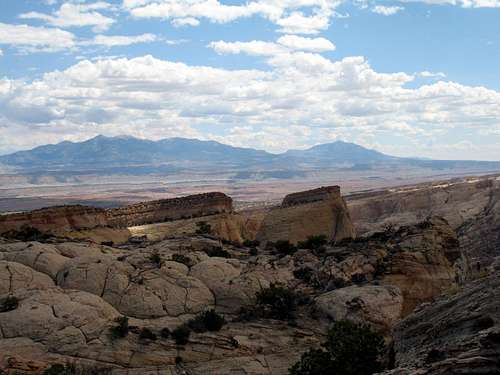 The view to the southeast
 Looking south
Warning
This is a hot hike in the summer and not recommended when the temperatures soar. Even in more temperate weather, take plenty of water and plan on a good chunk of a day to do this hike. One class three section has just enough exposure to allow me to make the recommendation that this may not be the hike for you if you are bothered by exposure or lack scrambling skills. A rope for making a rappel might be worthwhile. If you are a skilled backcountry hiker, I believe you will enjoy this hike since it takes you into the heart of rarely visited territory but please keep your impact minimal and leave it in as good a condition as you find it. That is why taking the washes will be the best way to reduce impact.Do not enter Capitol wash (even if the gate is open) in times of questionable weather. Flash floods in that canyon would not be a good experience.