-
 10198 Hits
-
 89.39% Score
-
 29 Votes
|
|
Mountain/Rock |
|---|---|
|
|
38.29866°N / 111.26329°W |
|
|
Trad Climbing, Scrambling |
|
|
Spring, Summer, Fall, Winter |
|
|
6387 ft / 1947 m |
|
|


Overview
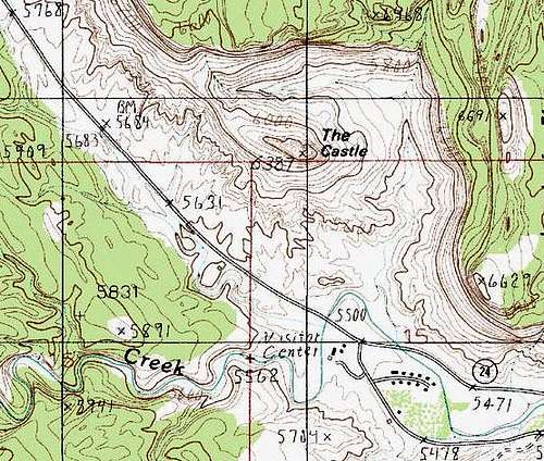
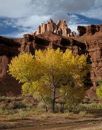
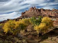
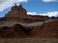
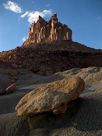
Everyone who drives through Capitol Reef National Park sees the Castle. Many of those people stop to photograph it. From a number of different points, the Castle is impossible to ignore, but it is perhaps most impressive when seen from the park’s visitor center, where it rises directly across the road, towering over cottonwoods and the bends of the Fremont River. It is not the largest or the highest of Capitol Reef’s formations, but it is one of the most recognizable and arguably the most spectacular.
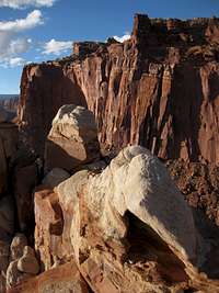
A pullout on the road identifies the formation, but there is no mistaking it, anyway. After just a glance, the beholder understands the name and agrees that the appellation is perfect. Sheer cliffs like castle walls wrap the peak, and rising above the cliffs is an array of rock spires resembling the battlements of a fortress. Overall, the shattered-looking visage creates the impression of the stronghold of the malevolent forces from some dark fantasy novel. Only the intense colors, especially early in the morning and late in the day, make it less like something from a nightmare and more like something from a dream.
Despite its proximity to the road and its fame as a postcard/snapshot subject, the Castle appears to see virtually no climbers or any other human visitors. An old trail sign near the base indicates there once was a maintained trail nearby, but none exists now. Capitol Reef has endless potential for technical rock climbing, but it is relatively undeveloped since it sits about halfway between the climbing meccas of Zion and the Moab area and is in one of the most remote areas in America accessible by paved roads. Finally, since there is no way to the top that is easier than Class 5 and even approaching the walls and towers is strenuous, few hikers and scramblers take the time to explore here. In fact, I saw not a single sign of human usage higher up, and I have not found any climbing beta for the peak online.
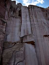
For the intrepid climber, the Castle is an incredible opportunity. It is composed of Wingate sandstone, known for its stellar cracks although rock quality can vary widely. My untrained eyes identified dozens of interesting lines, most of them cracks and chimneys, some leading almost to the tops of the highest towers. The quality of the sandstone and how well it would accept protection are beyond my authority to report here, though.

There are some downsides to the climbing, though:
· After the short, steep approach, climbers will find that many of the possible routes are only likely to be one or two pitches and may not consider the effort of getting there (really not all that much) to be worth it.
· Climbing in Capitol Reef does come with restrictions, as here copied from the official park website: “Capitol Reef National Park is a clean climbing area. Minimum impact techniques that don't destroy the rock or leave a visual trail are encouraged. The use of white chalk is prohibited. Climbers using chalk must use chalk which closely matches the color of the surrounding rock. The use of power drills is also prohibited. Bolts may only be used to replace existing unsafe bolts. Where it is necessary to leave or replace existing webbing, the webbing should closely match the color of the surrounding rock. Ropes may not be left in place unattended for more than 24 hours, and these ropes must be out of reach from the ground or other points accessible without technical climbing.”
Before reading on, please read this bit of full disclosure: I did not reach the highest point of the Castle, which is a pinnacle beyond my current abilities and equipment. However, I did reach several highpoints near the western end of the peak, and getting up there required Class 5 moves in addition to sustained Class 3 and 4 work. The highest spot I reached was 6290' in elevation. It is my hope that experienced rock climbers will add good route pages here so that SP will have firsthand beta about how to reach the tops of the highest pinnacles.
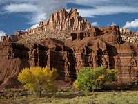 The Castle in October... The Castle in October... |
 |
 |
Getting There
Park at the visitor center and then walk back across the road, or park along the shoulder of the road near the bridge over the Fremont River.
Route Information
Find a place to cross the river. Crossing is usually easy, and you often can find a place to hop the rocks so that your feet don’t get wet at all. Head for the low red buttes ahead of you and follow a wash that approaches some gray bentonite ridges. Hike up these ridges (soft and loose, and treacherous and likely impassable when wet) and then follow the ridges up to the cliffs of the Castle. This approach climbs about 500’ in a little under a mile and will take many people only about half an hour.
 |
 |
 |
If you are here to do technical climbing, you now obviously make your way to the line you want to climb.
If you are a scrambler, you are not going to get to the highpoint, which is one of the pinnacles on the eastern part of the formation. But do not despair; if you are up for some moves in the Class 5.0-5.3 range and can tolerate some daunting exposure, you can still reach several of the pinnacle summits on the western end of the Castle.
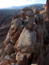
To do this, traverse around the eastern face and then along the north side. On the north side, there are two inset areas, like coves if the Castle were the land and everything else were the sea.
The first of these inset areas provides access to some of the highest pinnacles and perhaps even the highest itself. However, I reached a point where the climbing starting to become 5.4 or slightly harder, and shortly beyond that, it looked harder than that, so I turned back and climbed down and decided to look for another way up.
 North side North side | 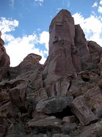 First inset area First inset area |
 Second inset area Second inset area |
The second inset area is near the western edge of the formation. Much Class 3 and 4 scrambling and three short pitches of Class 5 climbing (no harder than 5.3, in my opinion), got me atop the very narrow "summit ridge." From there it was possible to traverse over three or four smaller summits to the westernmost one of the complex. The traverse involved Class 3 and 4 moves and, in a few places, very serious exposure.
 |
 |
 "Summit ridge".... "Summit ridge".... |
 |
Red Tape and Camping
Red Tape-- See above for park regulations about rock climbing. For other regulations, see the NPS Capitol Reef site. There is no entrance fee for the park unless you are going south from the visitor center on the Scenic Drive into Capitol Gorge.
Camping-- Fruita Campground, part of a grassy oasis here and located near the visitor center, is a nice place to camp, with the Fremont River running by and plenty of Cottonwoods providing shade. The campground is popular and often fills on weekends and holidays and other high-visitation times such as spring break and the "color days" of October.