-
 8858 Hits
-
 79.04% Score
-
 10 Votes
|
|
Route |
|---|---|
|
|
41.37500°N / 106.285°W |
|
|
Mountaineering |
|
|
Summer |
|
|
Class 3 |
|
|
Moderate and steep snow plus scrambling |
|
|

Route conditions...


Scenery...


Overview
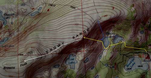
The shortest and easiest way to the summit of Browns Peak is to hike from Lewis Lake to the saddle between North and South Gap Lakes and then hike east up the ridgeline to the summit. The RT distance is only 3 miles or so, the elevation gain is around 1000', and it is all hiking.
But Browns Peak is a huge mountain with many ways up it, and some are more challenging, and more fun, than the quickest hiking route. One such route is from Glacier Lakes on the eastern side of the peak, accessed from Brooklyn Lake.
Like just about every other hiking and climbing route in the Snowy Range, this one starts high (10,600') and isn't very long (about 4.5 miles RT). Elevation gain is about 1300'.
The route, after the trail approach ends, offers a mix of scrambling and snow climbing to gain the broad summit plateau. How much there is of each depends on the conditions and personal preference. In the summer, you usually will be able to mostly avoid one or the other if you so wish.
Getting There
From WY 130, take the signed turnoff for Brooklyn Lake and Mountain Meadows Cabins. This turnoff is 33 miles east of the junction of WY 130 and 230 (this junction is between the towns of Riverside and Saratoga) and 8 miles west of Centennial.
Drive about two miles on this good gravel road to the entrance for Brooklyn Lake Campground. There is a very small parking area by the signed trailhead. Unless you are staying at the campground, you may have to drive back down the road a short distance (only 0.1 or 0.2 mi) and park at a larger parking area overlooking Brooklyn Lake and across from the start of the Sheep Lake Trail.
Note: WY 130 is closed in winter and usually does not open until around Memorial Day; it usually closes in October.
Route Description
From the trailhead, hike to Glacier Lakes. Most topo maps do not show this trail, but it is there and easy to follow. The lakes are at about 10,800' and are approximately 0.75 mi from the parking area. Get to the western lake and then look across it to study your options.
Note-- the highpoint visible is not the summit. It is an 11,462' false summit on the mountain.
As I noted in the first section, what you do will depend on conditions and personal preferences. I enjoy both scrambling and snow climbing, so I climbed up a snowfield (starts moderate, becomes steep) for two or three hundred feet up and then hiked a short distance until I was beneath Point 11,462. From that point, I climbed the rocks to gain the summit, encountering mostly Class 3 conditions but pulling an occasional borderline-Class-4 move. It does not need to be harder than Class 3, though.
The route from the lake to the false summit is steep-- you gain about 700' in less than half a mile. From the false summit, it is an easy hike of a little under a mile to the true summit. The highpoint of the mountain's huge, nearly flat summit plateau is a boulder pile out in the middle near the west end of the plateau.
Views are not that satisfying from the true summit because the summit area is so broad that it blocks all views down and consequently does not allow one to appreciate the vertical relief of the neighboring peaks. For better views, hike a short distance west, losing between 100' and 200' of elevation, until you can look down on the sparkling gems that are North Gap Lake and South Gap Lake and see the cliffs that rise above them.
Head back the same way or try a variation of the route. I hiked to a saddle a short distance east of Point 11,462, where I accessed a very steep snow slope for a nice glissade down almost all the way back to the lake. You could also hike west from the main summit to the saddle between the Gap Lakes and then take the trail system north or south around Browns Peak back to Brooklyn Lake.
Essential Gear
Ice axe if you plan to climb the snow.
I climbed at dawn and found the steep snow still hard enough at that time to warrant using my crampons. Later in the day, though, kick-steps will probably suffice.
A helmet is probably a good idea for the sections of steep snow, though I didn't wear mine. There was very little loose rock in the scrambling sections higher up.
Topo Map