
-
 7974 Hits
-
 85.87% Score
-
 21 Votes
|
|
Mountain/Rock |
|---|---|
|
|
46.84217°N / 11.24408°E |
|
|
Hiking, Skiing |
|
|
Spring, Summer, Fall, Winter |
|
|
7838 ft / 2389 m |
|
|
Overview
 Glaitner Hochjoch / Monte Fumaiolo Glaitner Hochjoch / Monte Fumaiolo |
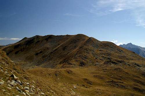
From Jaufenpass / Passo di Monte Giovo, which separates the southern Stubai Alps from the Sarntal Alps / Monti Sarentini, there runs a long ridge westward towards Hohe Kreuzspite / Monte Altacroce, where it suddenly turns to the north, heading for Botzer, close to the Stubai Alps Main Ridge. On this ridge the first four summits are easy hiking summits, the last and highest of which is Glaitner Hochjoch (also Schlotterjoch) / Monte Fumailolo. The ridge traverse to this point is very popular and there are several aspects which make it so.
- Access is easy: The starting point can easily be reached from the Jaufenpass Road. Close to the pass, about one km on the Passeiertal / Val Passira side there is a sharp turn in the road with a small parking lot. The first couple of summits, Saxner and Fleckner can be reached by ski lift in winter.
- The route is not difficult. There are two routes on both sides of the ridge as well as one which touches all the summits. Crowds disperse on the routes but tend to accumulate on the tops. Reaching the summits requires some easy scrambling but there's no exposure.
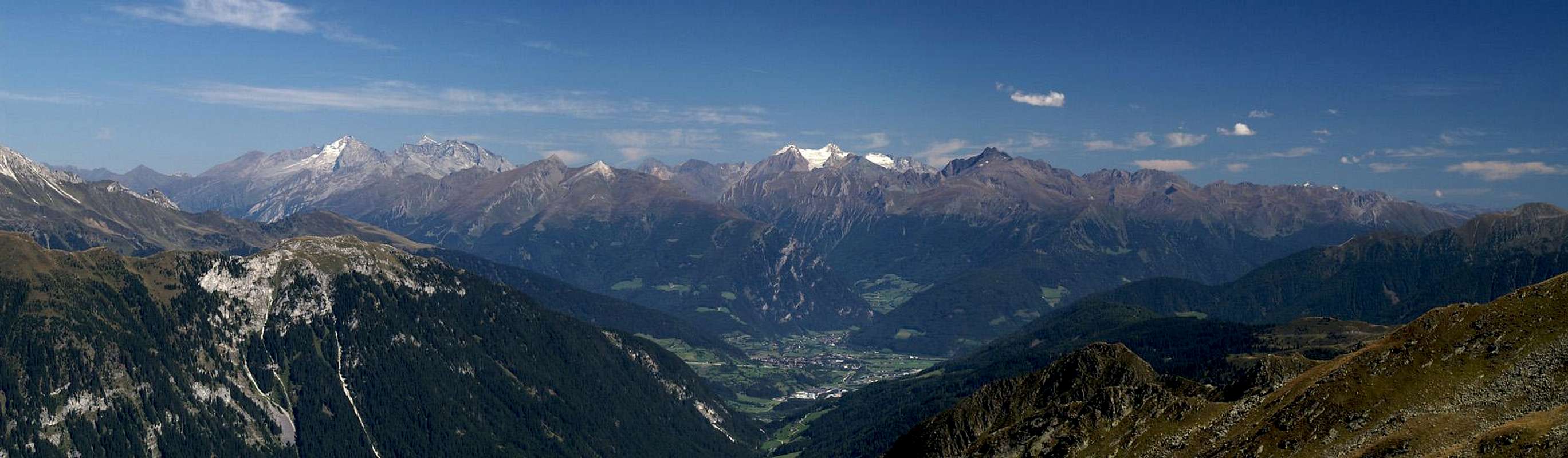
- Gorgeous Views: while the mountains themselves are not overly spectacular their position high above the Ratschingstal / Val Racines and Paseiertal / Val Passira Valleys ensures perfect views all along the ridge and even better 360° views from the summits. Besides the aforementioned Stubai and Sarntal Alps you see the Ötztal Alps up close, the Zillertal Alps in the medium distance and the western Dolomites and the Brenta Group far off.
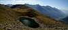
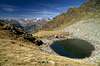
- A Goal to aim for: If you climb across Glaitner Hochjoch to its western side you'll reach the picturesque Übelsee Lakes, two beautifully situated ponds in the saddle between Glaitner Hochjoch and Kleine Kreuzspitze / Piccola Punta di Monte Croce
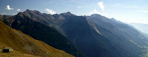
Glaitner Hochjoch itself has a rather long stretched and curved ridge. The highest point is at its western end but you can hike along the ridge at basically the same elevation for about one km until it suddenly drops with a steep grass slope to the saddle beyond. Since the regular hiking trail avoids this ridge, rather heading along the south slopes, it is a perfect place to settle down for a picnic, taking in the hundreds of peaks visible near and far.
|


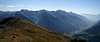
The summit views
  |
Getting There
 |
The mountain can be easily reached from the Brenner Motorway A22. Take the exit Sterzing / Vipiteno and follow the signs for SS44 in direction Jaufenpass / Passo Giovo. Drive accross the pass and start at the first switchback curve (Römerkehre), where you can find a small parking lot a few metres beside the road.
From Meran / Merano take Passeier Staatsstraße (also SS44) in direction Timmelsjoch / Passo del Rombo and Jaufenpass / Passo Giovo. At St Leonhard / San Leonardo turn east (staying on SS44) until you reach the curve "Römerkehre".
|


Red Tape
 Sarntal Alps from Glaitner Hochjoch / Monte Fumaiolo
There is no Red Tape here except for camping regulations. You are not allowed to camp anywhere but on the official campgrounds which you can find at the mouths of the valleys. Also gates are requested to be closed though you find but few on the Jaufenkamm Ridge.
Accommodation
Rooms and Apartments
Eisacktal / Valle Isarco
Passeiertal / Val Passiria
Burggrafenamt
Camping
- The closest campgrounds are at Gasteig / Casateia in Ratschingstal / Valle di Racines and at St. Leonard / San Leonardo in Passeiertal / Val Passira. Both are located on SS44 to Jaufenpass / Passo del Giovo.
Huts
- There is one hut, Flecknerhütte close by but rather close to the trailhead near the Jaufenpass road. You can also use the hotels/restaurants at Jaufenpass / Passo Giovo, Jaufenhaus and Enzianhütte.
Weather Conditions
Maps & Books
Maps
- Digital Maps
- Regular Maps
- Sarntal/Val Sarentino
Kompass Map WK 056
1:35.000
ISBN: 3-85491-340-0
- Sterzing / Vipiteno
Kompass Map WK 44
1:50.000
ISBN: 3-85491-050-9
Books
- Meran-Burggrafenamt
Franziska Baumann
Kompass Guidebook WF951
Kompass Verlag
ISBN: 3-85491-386-9
- Rund um Sterzing
Henriette Klier / Walter Klier
Rother Verlag
ISBN: 3-7633-4167-6
- Rund um Meran
Henriette Klier
Rother Verlag
ISBN: 3-7633-4290-7
- Sarntal/Val Sarentino