
-
 3856 Hits
-
 77.48% Score
-
 8 Votes
|
|
Route |
|---|---|
|
|
46.85033°N / 11.23198°E |
|
|
Hiking, Scrambling |
|
|
Summer, Fall, Winter |
|
|
Most of a day |
|
|
Hike and exposed Scramble |
|
|
Overview
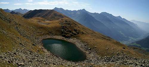 The Jaufenkamm Ridge above Übelsee The Jaufenkamm Ridge above Übelsee |
The hike along Jaufenkamm / Cresta Giovo is a popular tour which is done at all times of the year. Most of the hikers, however, won't get further than the first summit, Fleckner (2331m) and the "hiker density" will decrease with every further summit. After the lakes at the south-eastern base of Kleine Kreuzspitze you will only encounter a handful of people. The ridge towards Hohe Kreuzspitze almost always is void of any climbers.
The traverse climbs three summits before it even reaches the base of Kleine Kreuzspitze: Fleckner (2331m), Saxner (2358m) and Glaitner Hochjoch (2338m) all of which are fairly easy to reach. The last, Glaitner Hochjoch, is a long stretched ridge with two ascent routes. It is advisable to leave the trail and climb the east ridge and enjoy the summit views on that long summit ridge.
From Übelsee on the climb gets serious, first by climbing to a col on the south ridge of Kleine Kreuzspitze, then by traversing the western slopes across loose rock. Finally the route reaches a saddle where the Kleine and Hohe Kreuzspitze ascents separate. Kleine Kreuzspitze is reached via its west ridge, a short but exposed climb while Hohe Kreuzspitze can be climbed along its very long and often very exposed east ridge.
Getting There
Get off the Brenner Motorway (A22) at Sterzing / Vipiteno and take SS44 to Jaufenpass / Passo Giovo. In the first switchback curve after the pass leave the road and park your car in a small parking lot (approx 20 cars) above the Jaufenpass road.Route Description
 Ötztal Alps seen from the path
- Start altitude: 1850m (Römerkehre at the Jaufenpass / Passo Giovo Road)
- Summit altitude: 2518m / 2743m)
- Prevailing exposure: S
- Type: 3h / 4h over marked paths
- Protection: Unprotected
From the parking lot at Römerkehre west of the Jaufenpass road first hike straight up to Römersattel, a saddle which was in use even in Roman times. There you reach the crest of Jaufenkamm / Cresta Giovo) which you don't leave until you reach the lakes to the base of Kleine Kreuzspitze. You turn left onto the ridge and follow a cattle fence along the crest. It leads to the upper station of a ski lift from Ratschings / Racines, from where it slowly ascends towards the first summit, Fleckner (summit cross, 2331m). Here most of your fellow hikers will stop to return via Flecknerhütte on its south slopes.
The Jaufenkamm traverse now descends to a little saddle to head up again to the Saxner summit (2358m), from where it heads down to Glaitner Joch. Here a path from Passeiertal / Val Passira in the south meets. The marked path now leads through the southern slopes of Glaitner Hochjoch, however, you can also directly climb to its summit crest via the east ridge, in which case you avoid any remaining crowds and are awarded with great views.
From Glaitner Hochjoch the path descends into the next saddle, Schloter Jöchl, where again two paths meet, one from Passeiertal in the south, one from Ratschingstal / Val Racines in the north. A sloppily marked path leads to Übelsee, where you have to take the northern shore for the further ascent.
This leads up a steep couloir towards a saddle in the south ridge of Kleine Kreuzspitze. Here you can start climbing the even steeper south ridge or follow the marked path across the south-western slopes of the mountain to its west ridge where an additional path meets from Ratschings.
For Kleine Kreuzspitze turn east onto the west ridge and scramble it up to the summit of Kleine Kreuzspitze. The scrambling is not too difficult, however the footing is rather brittle and the ridge is exposed.
For Hohe Kreuzspitze turn west and pass some obstacles on the ridge along ledges on its southern side. You'll reach a second saddle, where again a path from Ratschingstal joins, then scramble up the long exposed ridge. It is not very steep, only exposed.
|

