The Grand Loop...
Pictured Rocks National Lakeshore is a linear park. Loop hiking within the lakeshore is quite limited. The Grand Sable Loop along with the more popular Chapel Loop to the south are about the only two options for a good, long day-hike loop within the park.
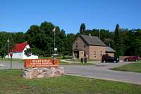
The loop runs around a large piece of trackless piece of real estate known as the Grand Sable Dunes. A good place to start is at the Grand Sable Visitors Center just east of Grand Marais. There is a large parking lot for backpackers, water, and bathrooms at the center which are all nice things to have before a day out. From the visitors center you can head east or west. I chose to head west so I would be
descending the dunes at the Log Slide instead of having to make a rediculously tiring ascent halfway through the hike. It also saved the more scenic part of the hike for the end which I always prefer.
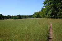
Heading west from the visitors center the trail passes through forest and field for a bit more than a mile before breaking out along the shore of Grand Sable Lake. The trail is forced to follow the road here for about a mile as the dunes press in along the north shore of the lake. Once you arrive at the west shore of the lake the trail heads back into the woods for a pleasant walk along the lakeshore. Before long (within a mile) the trail climbs away from the lake and for the next few miles (with the exception of crossing H-58) is surrounded by the thick northern hardwood forest that is typical of this area of Upper Peninsula. The trail passes Masse Homestead backcountry campground about a mile from the Log Slide.
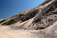
After hiking 6 miles through empty woodlands it may be a bit of a shock to break out into the crowds you'll likely find at the Log Slide. The views you'll find here though will ease your pain though...they're awesome. To the east the 300-foot high ramparts of the Grand Sable Banks rise out of Lake Superior at seemingly impossible angles. The secret of the Banks is that they are made up primarily of glacial debris (gravel) which can set at much steeper angles than dunes made of sand. The Grand Sable Dunes sit perched atop the Grand Sable Banks adding an additional 100 feet to their height. The blues of the big lake against the pale brown of the dunes makes for a stunning scene.
Now its time to head down to the lake. Watch your step on the way down. Like I mentioned earlier these dunes are made up in large part of gravel and it can be easy to loose your footing if you're not careful. If you fall here it will be darn near impossible to stop unless you've decided to bring along an ice ax. At the bottom take a look back up and be thankful that you don't have to climb back up! From the base of the Log Slide you'll simply be following the beach. This is not technically a trail but the beach is generally wide and open making for easy travel. For the first ways you'll be aiming for the high, barren dunes you see rising from the point in the distance. It's four miles out to that point which is farther than it looks. Keep in mind that for this stretch you are for the most part completely exposed to the elements.
***If you get in trouble you either have to backtrack to the Log Slide or make it to the trail at the Sable River.*** If you've picked a nice day and watch your step, however, you should be OK aside from roving bands of Stable Flies which can be a hassle on warm summer days.
As you near the point the beach turns from sand to gravel so walking gets a bit more tiresome but at this point you're only about two miles from the Sable River. After you round the point the dunes to your right lower significantly and you'll likely see people ahead enjoying the shoreline which means you're nearing the trail again. Don't worry about missing your turn at the Sable River you can't miss it. It's the first stream crossing of any significance you'll come to. Cross the stream (which shouldn't be a problem except during spring snowmelt) and you'll see the trail enter the woods to your right.
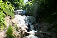
Once you're back in the woods the trail follows the Sable Creek for most of the remaining mile and a half back to your car. Along the way you'll pass Sable Falls which is definately worth a stop and a short side trail up into the dunes which give you your only real look at the dunes you've been circling the entire trip. I highly recommend the side trip. Past the dunes spur trail its less than a mile back to your car and those conveniences you'll miss so much...bathrooms and water.
Nuts & Bolts & Things to Consider...
Total Loop Length: ~12 miles (add a mile or so if you decide to do the Dunes Spur Trail)
Elevation Gain: Minimal unless you do the loop counter clockwise in which case you'll end up climbing the 400' sand dune at the log slide (I don't recommend this).
Access Points (east to west): Sable Falls Parking Area, Grand Sable Visitors Center, Grnad Sable Lake Overlook, and the Log Slide.
***Things to Consider***
Water - The only place well water is available along the route is at the Grand Sable Visitors Center. Along the inland portion of the trail you'll cross numerous streams as well as Grand Sable Lake which could provide water as long as it's filtered. There is no water for the six mile section along Lake Superior. You could try to filter from the big lake but without wading out into it this can be a pain (trust me, I've tried).
Insects - It's the North Woods, anytime between snowmelt and September some kind of biting insect is likely going to be out hunting for blood. Bring bugspray of the highest DEET concentration you can tolerate. Also, during warm periods Stable Flies can be a real nusance along the lakeshore. Bug spray doesn't work on these demonic little creatures and they have the ability to bite through multiple layers of clothing. If you're travelling to the area during a period of unusually warm and calm weather you might do better just to avoid this hike.
Lake Superior - Ol' Gitchee Gumee is notorious for its grumpy moods. Watch the weather closely before you head out on the six miles of beach you need to cross. With the exception of only a couple spots the beach is wide enough to be followed in all but the worst of weather. Remeber this though, you'll be exposed for nearly the entire time you're along the lakeshore. If a storm comes up you'll have precious little shelter to hide in. Trust me, climbing the dunes away from the shore just isn't an option.
Photo Journal...
![Grand Sable Visitors Center]() Grand Sable Visitors Center
Grand Sable Visitors Center![Trailhead @ Grand Sable Visitors Center]() Off We Go
Off We Go![Open Fields Along the Lakeshore Trail]() Open Fields
Open Fields![Grand Sable Lake]() Road Hike
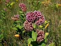
Road Hike![Common Milkweed]() Common Milkweed
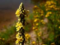
Common Milkweed![Common Mullien]() Common Mullien
Common Mullien![Poison Ivy]() Poison Ivy
Poison Ivy![Along Grand Sable Lake]() Shoreline Hike
Shoreline Hike![Grand Sable Lake Inlet]() Lake Inlet
Lake Inlet![West Shore of Grand Sable Lake]() Grand Sable Lake
Grand Sable Lake![Shelf Fungi]() Shelf Fungi
Shelf Fungi![Lakehore Trail Along H-58]() Crossing H-58
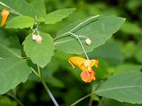
Crossing H-58![Spotted Touch-me-not]() Spotted Touch-me-not
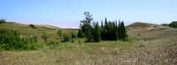
Spotted Touch-me-not![Grand Sable Dunes]() Green Dunes
Green Dunes![Hoary Puccoon]() Hoary Puccoon
Hoary Puccoon![Masse Homestead]() Masse Homestead
Masse Homestead![Lakeshore Trail East of the Log Slide]() Trees Everywhere
Trees Everywhere![Log Slide Overlook - Looking East]() Grand Sable Banks
Grand Sable Banks![Log Slide Overlook - Looking West]() Au Sable Point
Au Sable Point![Descending the Log Slide]() Caution, Steep Grade
Caution, Steep Grade![Grand Sable Banks]() Heading Down
Heading Down![Au Sable Point]() Au Sable Point
Au Sable Point![Along the Beach]() On the Beach
On the Beach![Water Seeps]() Seeps
Seeps![Gravel Dunes]() Sand vs. Gravel
Sand vs. Gravel![Shipwreck]() Shipwreck
Shipwreck![Fireweed]() Fireweed
Fireweed![Signs of Water]() Oasis
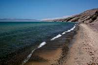
Oasis![Waves on the Shore]() Waves
Waves![Deserted Beach]() Deserted Beach
Deserted Beach![Exposed Shoreline]() Exposed
Exposed![Gravel Beach]() Gravel Beach
Gravel Beach![Rounding Grand Sable Point]() Grand Sable Point
Grand Sable Point![Sable Creek]() Sable Creek Outlet
Sable Creek Outlet![Sable Creek]() Sable Creek
Sable Creek![Sable Falls]() Sable Falls
Sable Falls![Small Cranberry]() Small Cranberry
Small Cranberry![Dunes Spur Trail]() Spur Trail
Spur Trail![Beach Pea]() Beach Pea
Beach Pea![Grand Sable Dunes]() The Dunes
The Dunes![Grand Sable Dunes]() Inland Dunes
Inland Dunes![Sable Creek]() Edge of the Dunes
Edge of the Dunes
Comments
No comments posted yet.