Preparation
Preparation began 3 days before the initial hike. Since Friday, my older brother planned to invite 2 of our cousins to join us on a hike. They agreed and planned to be ready first thing Monday morning. Originally, we planned to go to Little Black Mountain, but the weather conditions forced us to try Grandeur Peak instead. Early Monday morning, I woke up at 8:00 a.m. I, as usual, always do the Preparation. We got lots of Ice and stored it in the cooler. Along with it, went in 24, 10oz water bottles, and 6 Powerade bottles. This was barely enough for a group of 5 hikers. My older cousin, Nasir, wanted us to buy healthy fresh fruit. Despite the fact that he did not force us to buy any, we bought 4 bags of Pringles, 1 bag of some kind of chips I don't remember, and 2 Nutrigrain Bars. He got real upset at the summit!!!!!!
Hikers:
![User Profile Image]() Tahir R. (me) - 15 years old. That's what the "T" in Tmtn93 stands for!
Tahir R. (me) - 15 years old. That's what the "T" in Tmtn93 stands for!![Oldest Brother]() My Older Brother (19 years old)
My Older Brother (19 years old)![Younger Brother]() Haroon R. (9 years old)
Haroon R. (9 years old)![Tough Guy]() Nasir J. (18 Years Old)
Nasir J. (18 Years Old)![Ahsan]() Ahsan J. (14 years old)
Ahsan J. (14 years old)
Weather conditions:
Hazy
Sunny
90 degrees Fahrenheit
Low Humidity Level
*note that our age is actually how old we were when we did the hike, not our current age!
Beginning the Hike
Church Fork Picnic Area - 10:45 a.m
We parked our car outside of the Picnic Area. As we got out, we filled up 4 Backpacks with food, and water. My younger brother, Haroon, didn't carry a backpack (lucky kid). As soon as we reached the Picnic Area entrance, my cousins started doing some exercises. Finally, after 5 minutes of some of the weirdest stretches I've ever seen, we continued on up the paved road.
![Church Fork]() He Approaches With Satisfaction
He Approaches With Satisfaction
Unfortunately, my older cousin had to use the bathroom very badly, so we let him go. Outside for about 5 minutes we waited, no sign of him. We were going to ambush him, but since he took too long so we left for the final waterfall. My older brother managed to take a shot of him catching up to us. He had a big smile and looked very satisfied, looks like he held it in too long!
![Waterfall]() Final Waterfall
Final Waterfall
I was really surprised at the numbers of waterfalls in this small area. I thought only Bells Canyon had waterfalls like this. This water fall was the biggest one and also the nicest! Everyone else enjoyed them as well. So after spending a couple of minutes in the cool shade of the waterfall, we continued on.
The Beginning of the Journey
Near the beginning of the actual hike, we saw some machines building another trail. The first half mile or so the trail was pretty shaded, easy, and cool. As soon as we reached the Lower Switchbacks, the heat was on. This was our "Beginning of the Journey." We were like Frodo and Sam climbing Mt. Doom as Nasir would say. Thanks to the Switchbacks, the trail kept on going at a moderate pace. Sometime before the Upper Switchbacks, we met and old lady. She told us up ahead on the trail was a dead moose. Unfortunately, for us, we didn't see a single glimpse of the moose. Later, we all forgot about the moose until we were relaxing in the car. After we reached the Upper Switchback, we found a nice Boulder Field to sit and rest. My cousins decided to "Scramble" a bit up the rocks and gave up a few feet later.
![scrambling]() Scrambling
Scrambling![Giving up]() Giving Up!
Giving Up!
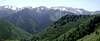
As the trail went on, the views kept getting better. we could see the beautiful canyon below.
![South]() The Canyon
The Canyon ![Wildcat ridge]() Keeps getting better
Keeps getting better![Panorama]() whole ridge is visible.
whole ridge is visible.![The All Mighty]() The best peak on the Ridge.
The best peak on the Ridge.
Every Minute that we hiked, the views kept getting better and better.
![SLC]() Salt Lake from the Junction.
Salt Lake from the Junction.
We continued on,and got our first glimpse of the Valley below from the Junction.
This is also the point where I realized that our video Camera was on for the past 30 minutes inside of my younger cousin, Ahsan, backpack. It drained most of the battery so we couldn't record anymore.
![Hiking Party]() The Steepest Part of the Trail
The Steepest Part of the Trail
From here on until the summit, the trail was at it's steepest. Also this meant that I would be furthest behind because I'm the slowest.
![The Summit]() First Shot from the Summit.
First Shot from the Summit.
later on we met a man who told us to be careful. He had spotted a Rattlesnake on the trail. We knew rattlesnakes were common on this trail, but like the moose, we didn't see any rattlesnakes either. We continued on and finally after a while, made it to the Summit at 8,299 ft.
The summit
The Summit: 1:30 P.M
The summit is quite big and very comfortable. With Many great rocks and Flat surfaces, You really have great choice as where to sit. You can comfortably find rocks to sit on to gaze anywhere, from the Valley to the West, or the Wilderness in the East.
![Salt Lake Valley]() A great view of Salt Lake Valley to the East.
A great view of Salt Lake Valley to the East.![The Foothills]() A great view of Downtown SLC and the Foothills to the North-East.
A great view of Downtown SLC and the Foothills to the North-East.![Grandview Peak]() Grandview Peak and its neighbors provide a Spectacular view to the North
Grandview Peak and its neighbors provide a Spectacular view to the North![Panorama]() A great view of Mount Olympus, Lone Peak, Triangle peak, Wildcat Ridge Peaks, Mount Raymond, Gobblers Knob, and Thaynes Peak to the South
A great view of Mount Olympus, Lone Peak, Triangle peak, Wildcat Ridge Peaks, Mount Raymond, Gobblers Knob, and Thaynes Peak to the South![Looking East]() Finally a great view of Millcreek Canyon, Mount Millvue, and Murdoch, Church Fork Peak, and Mt Aire to the East.
Finally a great view of Millcreek Canyon, Mount Millvue, and Murdoch, Church Fork Peak, and Mt Aire to the East.![2 Reservoirs]() Mountain Dell and Little Dell Reservoirs
Mountain Dell and Little Dell Reservoirs
On the summit, we only stood for 10 minutes and then we had to run back down. The main reason was that there were too many mosquitoes. Haze was another problem, the Oquirrh Mountains were barley visible across the valley. The Unitas as well as Desert Peak were invisible. We had a great time, and stood up there until another group of hikers came along. So then we started our Journey Down.
The actual time of the hike was 2 Hrs and 5 Minutes, but because we had to walk up the paved road, my cousin had to use the restroom, and we sat near the water fall, the final hike time was 2 Hrs and 35 Minutes.
The Journey Down
The Journey Down, as opposed to the journey up, was quite faster, and more exhausting. As we made our way down this merciless trail of doom, we realized that only god himself could guide us down. much for that plan, we aren't exactly the religious people who would sit down and actually wait for god to bring us down, so we continued on. Even god on a day like this would be at home eating ice cream, but we wanted to show our cousins the greatness of the mountains. The snow on the nearby mountains made me want to have a huge bowl of Vanilla Ice Cream. My older cousin, Nasir, on the other hand, wished he could ski down this mountain.
![The Wrong Trail]() The wrong route that we took, my brother wasn't liking this!
The wrong route that we took, my brother wasn't liking this!
In the first 10 minutes of our hike down, we started going down a wrong path. I was wondering why I didn't remember climbing up a steep slippery trail. Luckily for us, there was some guy ahead of us who warned us to turn back. Had we not turned back and found the real trail, we would eventually have to go through a steep bushwhack down the mountainside.
As soon as we got back up, we realized where we made out mistake and then we started going down the right trail. We had a military thing going on with one person in lead and one in back. So for the rest of the hike down, we had to stay in formation. We hurried as fast down as we could until we reached the stream, where we sat and enjoyed the cool afternoon breeze.
![Nasir s Ambush]() Nasir's Ambush
Nasir's Ambush
From here on until the end of the trail, we decided to play some "war games." With so much tree cover, it was easy to ambush your enemy. Our trekking poles were our guns, and as we went down we kept ambushing til we reached the Picnic Area. While it was kind of "Immature," We had a grand old time.
In order to get down to the car faster, we took a small alternative trail. Now we were worn out and getting home was what was on everyones mind. This trail led to the roaring stream. Not wanting to go back, we stepped in the water and walked across the cold fresh water.
The end of the journey.
As my cousin would say "the beginning of our journey," this whole incident became known as a journey. The end of the journey is when we were sitting in the car. Everyone was so tired, no one said a word for the rest of the trip. Although this might of marked the ending of an amazing journey up our first Real mountain, It marked the beginning of our craze to climb higher and much harder peaks.
Although as much as we would like to climb higher peaks in the following month, another problem came upon us. Our house did not meet the minimum landscaping requirements, so for the next 2 months, we only did 4 hikes. Most of our time was spent sodding, fixing sprinklers, and removing weeds. Had we not done this, West Valley City would charge us $1,100
Comments
No comments posted yet.