
-
 23493 Hits
-
 87.31% Score
-
 24 Votes
|
|
Mountain/Rock |
|---|---|
|
|
40.78960°N / 119.43°W |
|
|
Hiking |
|
|
Spring, Summer, Fall, Winter |
|
|
8974 ft / 2735 m |
|
|
Overview
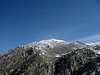
Granite Peak (8974') is the highpoint of the Granite Mountains, the aptly named desert range that towers over Gerlach, NV and the Black Rock Desert to the east. Driving along Nevada Highway 447, the mountain dominates views to the north, and can't help but attract the attention of the desert peakbagger passing through the area. It should be no surprise that so prominent a peak boasts some superb summit views: It is the highest peak for over 50 miles in each direction, and ranks #47 on the Nevada prominence list. And, as a bonus, it features some enjoyable scrambling as well for those so inclined.The peak has very little brush, and as a result a number of routes are possible. The peak is typically climbed from the west, from the vicinity of NV Highway 447, via one of any number of ridges. Typical round trip stats for these options are modest, on the order of several miles and 4000-5000 feet gain, allowing for an enjoyable half-day excursion that can be combined with one of several nearby peaks, such as Kumiva Peak, Mt. Limbo, or Tule Peak. An approach from the southwest side is particularly recommended; it is scenic, and has some enjoyable optional third class sections.
Notes: There is a separate named point marked "Granite" on the map, 1.7 miles to the north of Granite Peak. This benchmark is 17' lower than the range highpoint (8957').
Unfortunately, Granite Peak's prominence has caught the eye not only of peakbaggers, but of telecommunications companies as well, and a radio tower is consequently found on the summit. This is an unsightly blemish, but one that's worth overlooking in favour of a visit anyway. The peak actually has two summits along a northwest-southeast ridge; the radio tower is located at the southeastern end, and this is the point named as Granite Peak on the 7.5', but the northwestern summit appears to be the true highpoint.
 |  |
Getting There
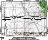
The exact starting point depends on your choice of routes; for an approach from the southwest side, proceed as follows.From Reno, take I-80 east for approximately 25 miles to exit #43 (Pyramid Lake/Wadsworth). Drive north on NV 427 for 1.5 miles, and turn left on NV 447, driving approximately 75 miles to the small hamlet of Gerlach. (Consult this overview map to get an idea of where this obscure town is located).
From Gerlach, drive north on NV 447 for 11.3 miles to an unsigned dirt road on the right; this road is located 0.4 miles north of mileage marker 86, and 2.4 miles north of the Flanigan/Susanville turnoff. Turn right onto the dirt road, as shown on this map, and follow it for 1.3 miles to a 3-way junction. Turn right at this junction, and drive for 0.7 miles to the top of a hill, where a 4WD track heads left. Park here. The road was in good condition and easily passable to a Subaru Forester as of April 2005.
 |
Red Tape
Like most Nevada peaks, there is no red tape whatsoever.When To Climb
The peak can be climbed year round, although it would be madness to visit during summer. You can expect to encounter some snow at the higher elevations during winter and early spring, but not enough to be a serious impediment.Camping, Lodging, and Supplies
You can camp anywhere around the peak on BLM land. Lodging is available in Gerlach, or further afield (and likely more cheaply) in Reno. Gerlach has a gas station (hours unknown), while Empire (approximately 6 miles south of Gerlach) has a small market with a limited selection of food and drinks.Mountain Conditions
NWS Forecast for Gerlach, NV. |
External Links
- Pete Yamagata's trip report - May 9, 1981
- Prominent NV peaks
List of Nevada peaks with 2000 feet of prominence, including Granite Peak (#47).
ScottyS - Sep 20, 2006 6:47 pm - Voted 10/10
True Summit Location?When I visited this peak in 2005, it seemed pretty apparent that the true summit is the knob a couple hundred yards WNW of the radio tower. While the radio tower location is marked as the summit on the USGS map, it wouldn't be the first time that the truth slid by them. I added a couple of photos, each taken from the opposite location, to help my case, but only with a clinometer or survey-grade GPS could this problem be solved for certain. My friend Stan Wilkinson who was along on the trip concurred. Judge for yourself, but look for the register at the higher of the two points...
Matthew Holliman - Sep 21, 2006 1:12 am - Hasn't voted
Re: True Summit Location?Hmm, thanks for the comment. The two summits seemed close in height to me--but at least when I was there, the (or maybe I should say, a) register was located on the summit with the radio tower. Frankly, I was too lazy to go over and check the other summit for another book. :-)
ScottyS - Sep 21, 2006 8:24 pm - Voted 10/10
Re: True Summit Location?Ah, like I said, a pocket clinometer would solve the problem pretty quickly. Personally, I think the reason the register was on the lower point is because the DPS (or whoever placed it) gravititated towards the radio facility. The tower is where it is because of the wide, flat nature of that location. Did you see the two photos I posted? What do you think?
Matthew Holliman - Sep 21, 2006 8:48 pm - Hasn't voted
Re: True Summit Location?No, I hadn't seen them--but I just took a look, and now I'm inclined to agree with your assessment. I'll amend the page later today. Dang, guess I have to climb this one again. :-)
Dean - Jul 3, 2014 1:41 pm - Voted 10/10
Re: True Summit Location?The same thing happened to Dennis P. and I on Nannies Peak near Elko. We thought we had climbed the high point and it had a benchmark and register only to find out later that the true highpoint was a couple hundred yards to the north. Dennis and I made the return trip and got the true summit so we climbed the thing twice (and that sucks).