Thursday, May 7, 2020 - PREP DAY
Packed bags and loaded the car with gear, supplies, clothing and food.
![]()
Friday, May 8, 2020 - TRAVEL DAY
Departed Minneapolis at 4:30PM. Drove through the night and made great time. Directions were incredibly simple; I94 into I90, then hwy 78 to Fishtail to get on West Rosebud Rd. About 14 hours total and gained an extra hour due to time zone change. Each of the 4 of us did a 3-4 hour shift and agreed the drive out was not nearly as bad as we expected.
Saturday, May 9, 2020 - PREP DAY
Arrived on West Rosebud Rd at ~5:00AM as the sky was starting to brighten. There was ~2 inches of fresh wet snow on the road and several deer along the side. It was a bumpy ride up through plenty of muddy puddles but we were following fresh tracks from someone before us and had no issue getting to the trailhead. Emerald Lake campground was closed until May 15th however we found multiple groups ‘dispersed’ camping between the road and the creek.
We found a camp spot, ate doughnuts, set up two tents and immediately went down for an early morning nap to make up the sleep we lost on the drive. One by one we staggered out of the tents between 9 and 10AM noticing most the snow from earlier was already gone. After getting settled we walked to the trailhead to get our legs moving and see the area. We visited lakes, used the restroom facilities and toured the hydro power plant and infrastructure.![]()
![]()
The rest of the afternoon was spent laying out gear, packing our backcountry packs, organizing food and meal prepping a hearty breakfast for the next morning. Everything was ready for a 5:30AM wake up to break camp and make the desired 7AM start time.
![]()
![]()
![]()
Sunday, May 10, 2020 - TRAIL DAY
Broke camp shortly after our 5:30AM alarm. We shared a breakfast hash consisting of sausage, potato, broccoli, egg and cheese in a pot prepped the day before. The car was loaded to the top after moving the YETI and bag from the luggage rack into the car. Everyone but the driver did the drive with their backcountry bag on their lap in order to make it fit.
![]()
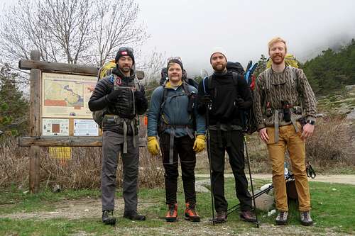
We used the facilities, took a picture near the trailhead sign and set in towards Mystic Lake by ~7:30AM. The trail starts just above 6500’ elevation and is smooth and direct gaining ~1300’ to the lake. More snow accumulated as we worked our way upward but it was well packed from previous hikers and easy to follow.
![]()
By the time we made it to Mystic we were in a thick fog preventing us from seeing anything that surrounded us. We could not see the lake even as we walked along the shoreline. We paused for some water, a snack and to don our snowshoes before committing to the switchbacks. It was a bit tough finding the Phantom Creek Trail #17 sign because of the fog, snow concealing the trail and having opted to walk on the shore. We backtracked inland a bit before finding the sign and trail.
![]()
We were likely off trail moments after starting towards the switchbacks. Everything was covered in snow and visibility was not ideal. We ‘chose our own adventure’ on the switchbacks and did what we thought best by basically following the path of least resistance. At one point we popped into a gully under a couloir above and agreed to turn back because it looked like we would not be able to exit later. We returned to the steep snowshoeing and high grade side stepping that was straining our ankles. Two of us switched from snowshoes to crampons. The relief from their ankle torsion was quickly greeted by the frustration of postholing.
The trail finding was inconsistent and just as soon as we found a trail line we would lose the next. We knew there was one switchback in particular that crossed left over the gully we had to pass. Our strategy was basically to get high enough and cross close to where we thought the trail was and plan to find the continuation on the other side.
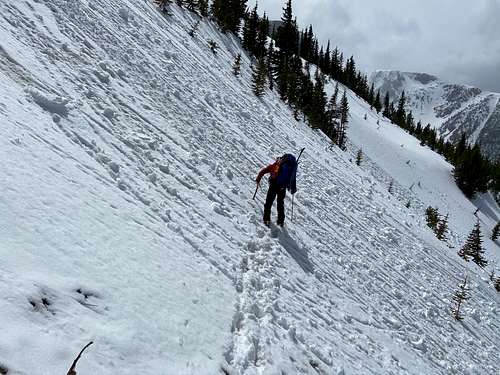
Once high enough we committed to the traverse. We followed exposed rock outcroppings and avoided moving through the center of the ~45 degree wall of snow. It was an exposed section where we moved slowly and found it necessary to use our axes. By the time we had crossed we could see two distinct switchbacks outlined in snow about 400 feet below us. We had far surpassed where we were supposed to cross but were more than relieved to find the trail pick up on the other side.
![]()
Following the trail from this point was a bit easier. We made our way through the remaining wooded switchbacks until the trees completely thinned out and the steepness rounded off. Visibility was still low so we took a couple of navigation stops to reference the map, compass and GPS. Eventually we found a large cairn but it ended up confusing us more than helping.
We think the cairn was an indicator for us to stay on Phantom Creek Trail (which heads west to east just north of Froze to Death Plateau). Since our objective was to get on the plateau we figured we should depart from the cairn on a southeast bearing. The problem was that the north and south sides of the trail were major drop-offs. We were walking along a snowy ridgeline which made no sense when compared to the map. We were disoriented and unsure if we should follow what we thought was the trail or to veer off towards the plateau, requiring us to find a way down off the narrowing ridgeline. The only certainty was that navigating this would have been a lot simpler had we not been stuck in a thick and windless fog.
Ultimately we found a way off the snow ridge by taking a ‘as the crow flies’ approach to getting on FTD plateau. We located a shallow dip below the ridge where we effectively chopped though a small, wet and yellow cornice. We descended feet first into a wind carved depression positioned on our butts. Afterward we followed a bearing directly toward FTD and quickly made our way onto the plateau.
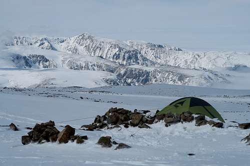
The ‘on ramp’ of FTD is a gradual and sustained uphill as you make your way towards the heart of the plateau. Our goal was to make it all the way across to the base of Tempest overlooking Granite but the exhaustion, visibility and the time of day made it clear we would come up short. We set up camp in the center of the northeast corner of FTD plateau. I was surprised how warm we all were. Despite the ‘Froze to Death’ name and reputation we were setting up camp in very windless and seemingly humid conditions. The tent was set up on a slight incline but it was easy to flatten with use of the avalanche shovel.
![]()
![]()
The rest of the evening was spent boiling water, sorting through the bear canister and eating dinner. We ate chicken noodle soup rationing half a pack of tuna per person. One of the guys felt pretty ill so the rest of us finished his food after encouraging him to eat as much as he could.
Monday, May 11, 2020 - TRAIL DAY
We didn’t set an alarm because our new goal for the day was to make it across FTD plateau to the base of Tempest Mountain. There was ample time in one day to complete this. We woke up to strengthening winds and snow accumulating on the west facing side of the tent. The changing weather systems gave us our first sights of our new alpine environment. Gaps in clouds would show us glimpses of the plateau’s ridgeline or a snowy peak of a distant mountain. We spent the morning eating oatmeal with nuts while taking pictures from/near the tent whenever the opportunity presented itself.
![]()
![]()
![]()
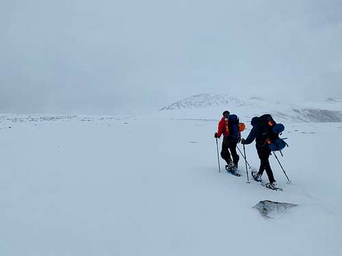
It was somewhat windy with a moderate amount of snow in the air. Visibility across the plateau wasn’t great but it had improved drastically from the previous day. At least now we could identify features on our path to help maintain course.
![]()
We weren’t tracking time so I’m unsure when we departed from camp. My guess is somewhere around 9AM after a leisurely morning. We needed to gain another 400’ while on a south west bearing before turning more westerly to cross FTD proper. We ended up gaining about 1k’ and found ourselves stationed over half way up Froze to Death Mountain. What we lost by over shooting our distance was more than made up for by gaining the elevation. We maintained the gained elevation by skirting around the south side of two highpoints just west of FTD Mountain.
![]()
Once in the center of FTD plateau we had two options to get to the base of Tempest near Granite. We could take a straight shot southwest or head further west near the ridgeline then pivot almost directly south. The straight shot is a shorter distance but has a more severe elevation gain. The west then south option is further but has a more gradual rise. It also had the chance of giving an early view of Granite which I thought would get the team excited. We ended up taking the west then south route which may have been a mistake. It was very windy near the ridge and the ground was entirely exposed rock for us to navigate through in our snowshoes. We used this delay to eat our PBJ tortilla lunch before maintaining course.
![]()
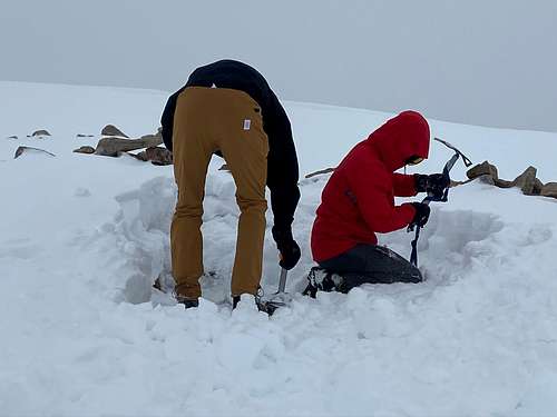
After keeping our southern trajectory we stumbled right into rock retaining walls at the base of Tempest Mountain. We arrived in the early afternoon around 2PM. Being the only group for miles we took the tallest and largest tent bed. The four of us made quick work of emptying the snow and clearing a spot for the tent. It soon became clear that these spots were too small for a 4 person tent. We recommitted a few more times to digging deeper and removing rocks that were obstructing our ability to get a shelter in place.
![]()
The wind was as severe as we had been warned for camping in this spot. Sustained winds in the 20MPH range with gusts up to 40. The forecast predicted higher winds arriving in the evening into the next day. We had ample time to secure the tent using a combination of snow stakes, rocks, ice axes, pickets and parachute cord to get the tent anchored.
![]()
We spent a couple hours at the site setting up camp without being given even a glimpse of Granite. It was obvious where to look but was entirely engulfed in clouds the whole time we were on location. It was probably about 4 hours after we arrived at the base of Tempest before the mountain revealed a sliver of its northeast face. The other 3 guys were in the tent and I was boiling water in the gap between the retaining wall and the tent. I stood up to move a water bottle when I caught a first look at the state high point. Shortly after the whole face was visible. I was extremely excited and demanded the other guys come out to see it but they were preoccupied in the tent and reluctant to put their boots on just to see it.
![]()
Eventually they agreed and together we took the opportunity to walk right up to the ridgeline overlooking Granite for a closer look and photo. The wind from the valley below Granite glacier, Huckleberry Creek and Avalanche Lake came roaring through at what must have been 50+MPH. The view of the mountain and rush of the wind got the excitement level very high for a summit push the next day.
![]()
The rest of the evening was spent boiling more water, eating food and lounging in the tent to stay warm. We discussed logistics and created a plan with a 4AM alarm for a 5AM start. We suspected high winds could be an issue but committed to waking up and getting outside to make any decisions.
![]()
Tuesday, May 12, 2020 - SUMMIT/RETREAT DAY
The alarm went off at 4AM as planned. It was later revealed that we were all thinking the same thing. It was way too windy and snowy for us to have any sort of attempt at the summit. None of us had slept more than a couple hours. The three season tent held up well considering it was dripping water on us all through the night and accumulating snow on the feet of our sleeping bags. Even though we were all aware this would be a no-go we stuck to the plan and geared up and got out of the tent.
Winds were constantly 30+MPH. The snow was whipping any which way and would change directions in a split second. Despite the conditions and doubtful thoughts going through our head we all walked to the overlook point to make the decision. We counted down “3, 2, 1” followed by a unanimous yell of “NAY”. Just like that, we were not going to Granite and instead going back to the tent.
![]()
![]()
We slept for a couple more hours before waking up to a brighter sky but similar conditions. We discussed our options and dwindling fuel supply for boiling water. We agreed we could quickly go bag Tempest, return and boil enough water to get us down the mountain.
Tempest was a bit harder than we thought. When you stand at the bottom it looks like the top is just a few hundred yards away. It sneakily keeps growing as you walk on it. But don’t get me wrong, it didn’t take a lot of physical exertion to reach its top. Once on top we sat on a big rock, said some words and took a nip of bourbon. We were unsure if some rocks ~30 yards away were actually higher so we walked over to touch them just to be sure we actually claimed our consolation prize. Then we were headed down. And down we would go for the rest of the day.
![]()
![]()
After boiling more water camp was broken quickly and we were headed in the opposite direction from which we came. It was a delight going both downhill and having the wind at our back. The visibility was clearing periodically through the day and we really didn’t need to rely on GPS/compass much having known the features now.
We made haste crossing the plateau and passed the opposite (north) side of the highpoints west of Froze to Death Mountain being sure to follow the contour lines instead of dipping too low and having to go back uphill later. Eventually we crossed right by our camp from two nights earlier. It was barely recognizable having been filled back in with snow but we could identify our footprints and followed them back to where we came.
![]()
I was eager to see the surroundings near where we first entered Froze to Death. Our appearance on the plateau was equally strange and fortunate so my wish was that it would make a lot more sense coming back through it. Oddly enough we lost our tracks and took a different way off than how we came on to the plateau. We did find a feature that looked like the miniature depression and cornice we had scooted off of but I wasn’t certain it was the same. There was no evidence of us breaking through and sliding off. Instead we walked around the side and worked our way around then down it.
At that point we found ourselves back in the treeline and opted to remove snowshoes for crampons before moving back into the switchbacks. Once equipped we descended through some trees and found our old tracks in moments. From there we saw the line of our traverse a few days earlier. It was funny and alarming how far off we were from where we were supposed to be. This time around our traverse would be more than a few hundred feet below the one we took on the way in.
The traverse was pretty straightforward but the snow conditions were not. It was a very wet slushy snow and we were caught in the mid-afternoon sun. There was plenty of evidence of moving snow earlier in the day and just before I set off a cluster of small pinwheels rolled by us. We made the decision that we needed to cross here and now; speed and spacing would be most important. We went 1 by 1 and only took two short breaks near clusters of trees in the middle of the exposed snow. My glove liner was soaked with cold melted snow from plunging the axe spike fully in on each step. It took about 15 minutes to cross in total but by the end I was breathing heavily and ready to be off the snow and back on trail.
![]()
![]()
After the traverse we found our footprints again and continued to follow them. More than once we were able to deviate from our footpath to stay on newly visible actual trail. Considering it was a warm afternoon and we were in crampons we might as well have been walking through posthole city. Every few good steps earned you enough trail karma for at least one thigh high posthole. I broke one of my trekking poles swinging my foot around coming out of back to back postholes.
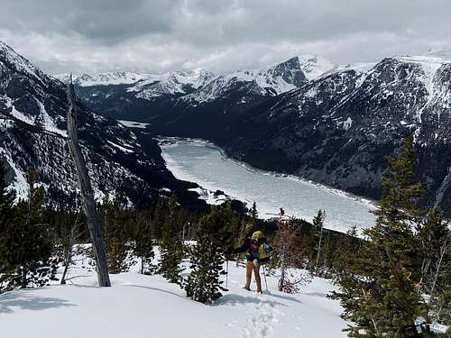
Slowly but surely our progress became evident as Mystic Lake grew larger and larger. The steep hillside tapered out and we were walking through the wooded perimeter of the lake. Our footprints led us right back to the Phantom Creek Trail #17 sign and we stopped on some log benches to drink more water and eat more salami.
![]()
We walked towards the dam along the shore with high spirits feeling like we were done with our hike out. All of us were caught off guard with how much more was left in the final 3 miles. The main surprise was how treacherous some of the tightly packed snow-turned-ice would be. One of us slid right off the trail into a steep embankment under some dripping icicles. We were very tired and it was showing in our reckless footwork. We continued at a slow pace until returning to the part of the trail without snow.
![]()
We reached the car around 6:30PM. It was close to a 12 hour day spanning over 15 miles and sinking more than 6k’ elevation. We were very pleased to be back at the car with water and other regular camping amenities. Camp was made at the same spot as before. We lounged in camp chairs eating beans, brats, macaroni and Doritos. Beer and wine flowed.


Comments
Post a Comment