After our
Longs Peak trip I started on my quest to find a nice class 3 Colorado 14er. While I was looking I came across pictures of the Colorado Wetterhorn and immediately wanted to climb it but was a little unsure about the summit pitch. I decided to try it and was able to talk my Dad and Christin into it as well.
August 19th 2006:
Not really wanting to spend the night at Matterhorn Creek T.H. or in Lake City, we left Colorado Springs at 2 A.M. The entire car ride all I heard was how stupid I was and why couldn’t I choose a closer 14er. We finally arrived in Lake City around 6:30, but unfortunately nothing opened until 8 or so (I don’t remember the exact time but we were there way too early); not even a gas station was open.
So we reached for our Cliff bars as we headed up the scenic-by-pass toward Engineers Pass. After forever we finally reached the 4X4 road to Matterhorn Creek T.H. For any of you that have never been on a 4-wheel drive road, try it, we laughed (none of us knew why we were laughing) ourselves silly all the way to the trailhead. It was about the roughest road I would want to take our 4-runner on (I can’t imagine what South Colony is like).
By the time we left the trailhead it was 7:45.
The beginning part of the trail followed a creek into a basin and seemed to be wider and in better shape than the 4X4 road. We quickly reached the first fork in the trail (go right, your instincts will tell you left, but go right) and started gently climbing a hill. Suddenly the peaceful day was interrupted by the sounds of a rescue helicopter as it circled around the Uncompahgre Wilderness. The images of Longs popped back into our heads and I started having second thoughts. This was the last thing I wanted, because now Christin and my dad were really upset that we had driven 5+ hours to an unsafe mountain. We heard the helicopter circle for several minutes before it faded away behind Wetterhorn. As we continued I began questioning myself,
“what was that helicopter doing? Where did he go? That summit pitch looks pretty bad to not have a rope”, but I just kept my mouth shut and hiked.
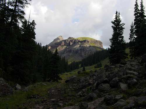
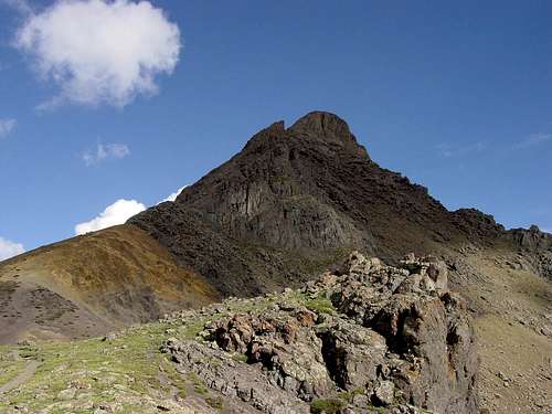
As we crested the hill we came into a basin created by Wetterhorn, Matterhorn, Broken Hand Hill, and Uncompahgre. The views of Wetterhorn and Matterhorn were amazing and Uncompahgre, in the early morning light, was a massive silhouette to the north. We came to the second fork (go left, there is a sign) and crossed
a creek two or three times before we started into Wetterhorn’s never ending boulderfield.
There is a trail through the boulderfield, but it fades in and out, so follow the cairns. From the boulderfield we could see several mountain run-offs and the picture-perfect blue sky was unbelievable.
Soon we started climbing towards Wetterhorn’s saddle (the saddle you want to gain is left of the yellow colored saddle and rock formation).
Once we gained the ridge the trail became much steeper, climbing left of the afore mentioned rock tower (easy, but steep) and we soon found ourselves
running and pulling our way up the yellow colored dirt saddle. This section of the climb is only rated class 2, but while you’re going up it and coming down it, it feels a lot worse. After reaching the top of the saddle (where the yellow dirt and rock meet) we stopped to rest and eat a little. From here we could see the start of the class 3 terrain, so we decided to leave our packs and just bring the camera.
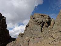
The rocky terrain was a welcome change from the steep dirt. The views of the valley (to the west) below were beautiful. We gained a small amount of elevation as we traversed the west side of the mountain. At this point there were still good cairns to follow and the climbing was fairly strait forward and easy. A few minutes later we were confronted by a rock rib that blocked easy access to the shark fin (the rock tower south of the actual summit). We had only one option, up toward the crest of the ridge. From this point the route became more serious. A convenient gully led us up to chockstone, from here we had one of two options, up around the rock formation on the right, or down climb through a nifty little (and I do mean little) v-slot. All three of us were skinny and didn’t have packs so we opted for the v-slot.
Once on the other side we followed the cairns to the ridge’s crest, here the cairns stopped and our problems started.
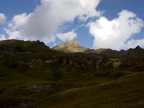
We stopped for a minute to take in the great views of Matterhorn, Uncompahgre, and the rest of the basin. I had remembered reading that the route stayed to the left after reaching the ridge, so we started climbing to the left. Unfortunately now I think that the correct route is to climb the crest of the ridge and don’t go to either the right or the left (this is what I heard and to be honest, I don’t remember what exactly the ridge looked like and I don’t have a good clear picture of the ridge). This quickly became very dangerous as the rock was very steep with loose dirt and the exposure was nothing to scoff at. Christin proposed climbing on the right toward the connecting Wetterhorn/Matterhorn ridge. Hesitant to deviate from what I thought was the correct route I tried for a few more minutes not to kill myself, while Christin and my dad started to climb to the right of the ridge.
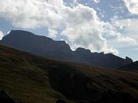
![Silhouette of Uncompahgre]()
I didn’t think that this was where we were going to have our problems, everything that I had read said stay left after reaching the ridge and climb to the notch between the shark fin and the summit block and once there then you had to deal with the summit pitch. After a frustrating five minutes or so I reluctantly climbed back to the ridge and followed the rest of my party. We only climbed for about two or three minutes until we ran into a rock obstacle that my dad thought was to dangerous to attempt. We looked around for some cairns, but didn’t see any. So again we climbed back to the ridge and pondered what to do.
I still thought that the correct route was to the left so I tried it again, but found no feasible way to climb to the shark fin, every option involved some sort of technical move on loose dirt. I paused for a moment and looked to the summit and saw a climber making his way off the summit. I climbed back to the ridge and told my Dad, who wanted to turn around.
"I saw a man coming off the summit, I think we should wait and see how he gets down here before we bag this.” He halfheartedly agreed. “I’m not going to turn around because were too stupid to find the route” I thought. “This is pathetic.”
Several minutes later we saw the climber coming down towards us on the right side of the ridge. I thought “what the heck, I’m sure the route description says go to the left. Uhh!”
Once he made it to the ridge I asked him which way the route was. He said that he had climbed the mountain several times and each time he had traversed the east face, then climbed up to the notch. “The east face is loose and there is exposure, but take your time and you’ll be alright.”
Not about ready to give up we started traversing the east face. It was comforting to know we were at least on some type of route. We quickly realized though, that the climber we had talked to wasn’t joking. The
ledge we were on varied from a few feet wide to a few inches and was covered in dirt. I remember at one point the ledge was about 6 inches wide and rock jutted out from the side. I gave the rock a big bear huge and slowly slid my feet underneath on the ledge. I had never dealt with exposure like that and I thought that it was fun and challenging. The loose dirt added to the effect of the exposure and made us think about every step. This part of the climb took awhile, but finally the opportunity presented itself and we climbed up to a large flat area at the base of the shark fin and summit. Here it is important to climb through the smaller notch to the right.
There is a cairn that marks the correct notch.
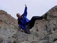
It seemed a little weird that there was such a large flat spot on a mountain that was so steep. We climbed through the notch and onto a ramp that lead to the west face of the mountain and the final summit pitch. This is the section that everyone talks about on Wetterhorn. When I walked across the ramp and saw the ‘stair’-like gully for the first time I thought “We’re doing what!?! Gheez, that’s steep!” Christin quickly walked over to the ‘landing area’ (small area at the base of the pitch only room enough for one person) and started to climb. I paused for a second looked at the exposure and said "so this is why they say bring a rope just in case…huh.” I turned around, stuck my face in the rock, and didn’t look back for awhile.
As I started climbing I thought “this isn’t too bad.” The pitch was very
steep, but the hand holds were good and only slight amounts dirt/loose rock covered the top of the ledges. I can see how some people might want a rope on this part, but honestly I think that it would just get in the way. After I had climbed for a while I looked between my legs saw the exposure and though this is totally awesome! The exposure was extreme, but for some reason it didn’t bother me that much. Christin and I got to the top of the first pitch, (marked by a ledge larger than the rest) waited for my dad who was a few steps behind, and followed a cairn left along that ledge to the last pitch. It was more of the same stair-like rock; we quickly climbed the last several feet and found ourselves on a fairly large and flat summit all by ourselves.
The feeling was amazing and the views were spectacular, it might be my favorite climb. We just stood there for a while and soaked it all in. God’s creation is absolutely amazing. The views of the valleys were as beautiful as the mountains. Tons of different colors, from yellow to blue to green, sprinkled valleys and basins below. I took several pictures including a panorama and thought, “only those who work for it, truly get to experience it. With no risk, comes no reward.”
After being on the summit for about twenty minutes we started to head down. Suddenly, the inviting looking ‘stairs’ on the way up, changed to what looked like a cliff.
As I started down I applied the
butt-scoot and bar dip method (I had ripped a pair of pants on the way down Longs and I would do it again). There was something kind of fun about crab-walking down the side of a mountain though, and I found the exposure only added to the fun. I thought I was kind of crazy for liking it, but my dad and Christin felt the same way. We were a lot slower going down then coming up, but eventually we found ourselves back traversing the east face and my opinion of it still hadn’t changed. I thought that it was the worst and most dangerous part of the climb. We took our time and slowly made our way back to the yellow colored saddle without incident. Some clouds had come rolling in over the summit and we were thankful we had gotten off in time (unlike some people we had passed on the way down).
All in all it was probably my favorite fourteener I have done so far. The climb was fun and the views were amazing. We saw a total of three other people the entire time on the trail which only added to the beauty of day. This is a great climb and I highly recommend it if you're not put off by some significant exposure.


Comments
Post a Comment