Introduction/Some pre-thoughts...
Peaks/Mountains climbed
| Peak Name | Elevation | Colorado Rank | Peak Name | Elevation | Colorado Rank |
| Vestal Peak | 13,864 | #77 | Arrow Peak | 13,803 | #104 |
| West Trinity | 13,765 | #120 | Trinity Peak | 13,805 | #103 |
| East Trinity | 13,745 | #128 | Peak Nine | 13,402 | #317 |
| Storm King Pk. | 13,752 | #125 | Peak Five | 13,283 | #412 |
| Peak Six | 13,705 | #144 | Jagged Peak | 13,824 | #94 |
| Leviathan Peak | 13,528 | #237 | Coxcomb Peak | 13,656 | #171 |
58.6 miles
Literature:
National Geographic Topo. #140 (Weminuche Wilderness)
Colorado Scrambles- A Guide to 50 select climbs...
Dave Cooper
Colorado's Thirteeners-
Gerry & Jennifer Roach
Colorado's Wilderness Areas-
Mark Pierson & John Fielder
Climbing trips are more than just proving yourself against some dirt and granite gradient or finding creative ploys to enjoy those Porters/Ale's in the guise of physical determination. Said outings provides all of us the opportunities to expound ourselves to like-minded fanatics who also crave landscapes that we hope, through the course of a few days or even a whole lunar cycle will reward us with experiences and ephinies that cross the Rubicon into the sublime and surreal.
I met
Brian Miller for the first time while I was on the David Worthington (Talusmonkey) memorial climb last spring as he was sitting at the Crestone Needle turnoff waiting for a slower friend. We struck up a quick platitude conversation. We both knew of each other but that was really about it. I left hastily chasing the rest of the hiking group as
Vince Tallevera and I were ghosting the rear of the pack talking and getting to know one another.
I had no idea that a year or so later, we would end up becoming very good scrambling/climbing friends and that he would in turn, serve as a kind of mirror, a reflection for self-improvement via the vernal, the new and lessons learned from failed friendships.
Forward to February 2008, Brian and I were sitting at Barnes and Noble in Boulder pouring over guidebooks and topographic maps like a couple glasses of spilled water trying to decide where to plan this epic climbing trip he initially e-mailed me about. This was a constantly evolving process that saw mountains and peaks get dropped off the itinerary only to be added again later at the behest of a few other deleted options. However, of one thing that was certain, Tabasco sauce. We would end up going through almost two bottles in the course of a week.
We knew this trip should and would take place in the San Juan’s but alas, the same questions came back like pesky mosquitoes: Which mountains to include? Which drainages should be traversed and explored? How much food should we take? Who to invite on this labour of love? Mild green, original red or smoked chipotle?
![Summit of Vestal]() Chris Ferraro on Vestal's summit
Chris Ferraro on Vestal's summit
In the end, it was decided to completely drop Chicago Basin and Ruby Basin (a little to my dismay) from the plan and keep our focus a bit tighter. We would end up setting our feet to the following course:
Ride the rails from Durango to
Elk Park and unload. Hike in and camp high in Vestal Basin. Over the next week, we would drop into Ten Mile Basin and finally into upper No Name Basin and exit out via the Animas, attempting mountains and peaks while en route. We would catch the train back to Durango where congratulatory beers were waiting for us in some bar or another.
With the exception of two stalwarts,
Vestal Peak and
Jagged Mountain, our list was flexible and quite malleable. And so with only three weeks remaining, we were finally set upon our course with an open, spicy buffet of 13ers.
Friday-Saturday
Butterflies and Death-Marches
Brian and his good friend, Chris Ferraro (whom I met earlier in the spring on a climb of Ice Mountain & North Apostle) left Denver late Friday afternoon flying west towards Vail to pick me up since I lived en route. I had all my stuff already packed up and ready to go in a new 85-L Osprey pack that I bought specifically for this trip.
“Now her hair was as black as a bucket of tar
Skin was as white as a cuttlefish bone
I left Texas to follow Lucinda
Now I'll never see heaven or home
I made a wish on silver of moonlight
A sly grin and a bowl full of stars
Like a kid who captures a firefly
And leaves it only to die in the jar.”
I have to admit; I was pretty dam apprehensive and had butterflies all day due to this trip. It’s the whole case of having something planned for months and months only to have the day finally come and wishing almost, that it didn’t. It’s almost as if excitement exists not in the action but in the thought of it. Weird. So I played
Tom Waits most of the day and had a few beers past my norm at Moe’s Bar-b-que down in Lionshead to drown the butterflies until Chris and Brian arrived.
A forth companion, Glen Maxson was already on his way down to Ouray. He would end up nabbing a cabin for us all to sleep in since the weather in Colorado is always suspect. Glen had just received the extremely good news that he got one of only four positions available at the Parker Fire Department out of a resume pool of over 120. So he would end up having to drive separately and leave early to take care of business. It sucked but hey, climbing mountains doesn’t pay bills, they create bills. He would hike in via Molas Pass, meet us at Elk Park and retrace his steps.
Saturday morning brought a patchwork of gray, overcast skies, rain and impressive fireworks over Red Mountain and Molas passes (I guess some butterflies know how to swim). Trekking ~7 miles in stormy weather was something none of us were looking forward to.
In Durango at the depot, the booth was unmanned. Cool! That would end up saving us $70.00 in parking fees! The weather, though still cloudy and suspicious was looking more promising. We had a quick breakfast at McDonalds and I thoroughly enjoyed my coffee flavoured cup of ice. Why do they do that? I wanted a cup of iced coffee and I got an iced cup of coffee flavoured ice. At least the train would have the hot stuff. So I kept my grumbling to a minimum.
When I was down in Chicago Basin a few weeks ago, it was my first time on the narrow gauge. I suppose due to freshman starts and inaugural experiences, the ride was exciting and wonderful. This time around on this sophomore trip, the train proved to be nothing more than a novelty. Since the
Denver and Rio Grande Railway actually founded the city of Durango in 1879 and completed service to Silverton in 1882, I suppose some respect should be shown since the institution is so old. It has after all been in continuous operation for 127 years. By the way, standard fares are now $75.00, FYI.
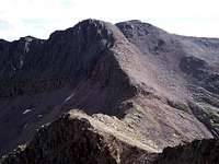
![Morning on Arrow Peak]() Arrow Peak from Vestal's summit.
Arrow Peak from Vestal's summit.
Standing there at Elk Park sorting gear, I felt like a celebrity. Everyone waved as the train slowly pulled away. I felt like I was in an edited clip from that stupid commercial on TV about boating with Samantha Brown (from the Travel Channel) where everyone is waving to each other.
“You’re really eating this up, aren’t you?” Chris said laughing since I was just standing there waving back ignoring my gear for the time being.
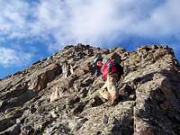
![Wham Ridge]() Looking up at Glen Maxson on "Whammy"
Looking up at Glen Maxson on "Whammy"
All right, time to get serious. I never weighed my pack but I’d put estimates that it weighed somewhere in the vicinity of 50lbs. I had the rope (60m-9.8mm) and all the climbing gear (#6,7,8 curve nuts-#5,6 hex nuts, .5 and .75 C-4 cams, assorted slings). Chris had brought Cooper’s scrambling book and Roach’s 13er book. Both of us had a Nat. Geo. #140 map and he brought “Desert Solitare” by Edward Abbey and I had a copy of “Reveries of the Solitary Walker” by Jean-Jacques Rousseau, you know, light reading. The hike up Elk Creek felt like a death march. I was hurting pretty bad. I was having trouble getting used to the new pack (specifically the straps) and adjusting my speed and stance for the weight. I fell behind for the whole hike in. Not even an eclectic mix of Funker Vogt, Assemblage 23, VNV Nation etc. could keep my speed any faster then the other guys (ipod). I didn’t think the hike in was anything extraordinary or spectacular, average in scenery I’d say, although we did get rained and hailed on for a short while. Past the beaver ponds, the trail climbs sharply and steeply. It is also generously covered in deadfall of all sizes. However, once we all reached Vestal Basin, I revised my opinion. It was a grueling march to get in there but Vestal Basin is beautiful. We finally reached a decent campsite and started to get dinner prepared (many thanks to Glen and Chris). My hamstrings and butt were shot. They had seen their limit and there was no way in hell I was going any further that day. That night, I slept like the dead. We ate, admired Wham Ridge and Arrow Peak, played with the mosquitoes and flies and retired for an early morning.
Saturday was a long day and not all of it enjoyable.
Sunday
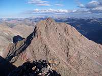
Vestal and Arrow Peaks
![Looking down Wham]() Looking down on Brian from Wham
Looking down on Brian from Wham is without doubt, a true Colorado classic climb. Gerry Roach really hit it on the head with this one. The aesthetics of this route have little else in Colorado that merits comparison. The approach is scenic, the terrain is almost ‘Middle-Earthish’, the rock is solid and secure with holds a plenty and the pitch is steady and mildly quantized.
We left camp shortly after 4:30am and due to a high spot in the valley, we reached the terminus of the grassy ramp just as the sky was catching fire with the first rays of dawn. The reds for some reason were as intense as I’ve ever seen them as if hell existed just to the north over Peak Three and White Dome. Watching sunrises so vibrant and violent with colour against the black dominion of night, it seems daybreak really struggles sometimes to usurp its’ influence over the nocturnal.
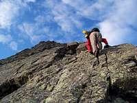
After a few photos, Glen and Chris started up ‘Whammy’. Brian and I chose to put on our rock shoes. Any opportunity to use them is a good opportunity to learn better movement (in my opinion). The bottom of Wham Ridge is quite easy and mellow. It has a gentle pitch with holds, nooks and steps everywhere. As it steepens, the holds do become less frequent and smaller but the rock retains its integrity. At the crux, Chris kept climbing through and didn’t realize it until he had passed it and found a nut stuck in the crack. Glen continued on around to the right out onto the west face and found what I would call a difficult class-4 chimney to shimmy up. Brian and I ended up doing the same thing by following Glen.
Past the crux, the ridge becomes steeper with a noticeable increase of talus present. Brian zigzagged on the ridge whilst I ventured out onto the north face. I got stuck at one point. I didn’t feel comfortable executing a move around a slightly bulging rock with the drop-off behind me, so I downclimbed around but still ended meeting Brian on the false summit at almost the same time. We walked over to the summit where Chris and Glen were waiting and gladly sat down. Chris had stated (and it looked it) that the low 5th crux was very manageable. The need to get out the rope was never put forth as a question.
The standard class 2+ walkup on the backside if it exists wasn’t playing nice. The climber’s trail was a patchwork of intermittent cairns, trail, old footprints and confusing scree. I’m assuming the ‘Janus’ nature of Vestal Peak (13,864ft) probably erases the climber’s trail from time to time due to rockfall and slides. We passed two rappel stations (slings) until we came to a bit of a quagmire. There was a large and steep fin blocking any kind of traversing movement and we were at the top of what looked like a small cliff band. Chris and I descended a bit into a smooth but tight corner. Chris lowered himself as comfortably as possibly and found there to be no holds. I moved out of the way and as he was regaining a safe perch, Glen, who had climbed up the fin above us, reported back that there was a way down the other side; we promptly followed. We were soon at the Vestal-Arrow saddle taking a break. The south side of Vestal is a complete mess and as we would find out tomorrow, Trinity Peak would be about par for the course.
We talus skied down to the start of the ramp on Arrow and cached our climbing gear. The ramp on Arrow Peak (13,803ft.) is very singularly cool! The views it offers of Wham Ridge are incredible; though if wet, I can see how this particular route would make for nervous dowclimbing. Brian led most of the way up followed by Glen and myself and Chris. We ran into an older man and probably his granddaughter on the way up. It was almost funny listening to them talk. He wanted to scale Wham Ridge the next day but the look on her face when he said this was that of, “What, are you on crack!?” I don’t think they ascended Wham the next day. They would end up being the last people we’d see in five days.
I really enjoyed Arrow Peak. Much like Vestal, the pitch of the rock was progressive and the holds were quite good and plenty. The views up valley towards Trinity Lake were amazing. Vestal Basin is a place all people should see at least once. The geology is so unique and the rock is a sheer delight to be on. I definitely intend to get back down there (probably via Beartown) to nab Peaks One, Two and Three and White Dome.
The downclimb off Arrow went smoothly and very quickly. It was as straightforward as one could expect. We arrived back at our cache but the day wasn’t over yet. Brian, Chris and I knew that we’d be coming back this way tomorrow. On the climb off Vestal, I suggested that we cache our climbing gear high in the basin between Vestal and West Trinity so we wouldn’t have to deal with it the next morning as we would have our larger packs with us. After getting a good look at the terrain on the other side into Ten-Mile from Vestal’s summit, we would stash our stuff here as opposed to the Trinity-Arrow saddle. So we traversed over to Vestal Lake, filled our water bottles, bid adieu to Glen who really didn’t need to continue any further (he wasn’t feeling too good anyway. I was still getting over a head cold and we think he might have caught a touch of it). We stashed everything we could, covered and tied it down. I built a large cairn to better mark it and we arrived back at camp near 3:00pm when we promptly laid down and napped till 5:00pm, basically dinnertime. Monday was going to be a long day.
Monday
The Trinities and traverse/descent into Ten-Mile Basin
![High Ramp on Arrow]() Glen Maxson on the ramp on Arrow Peak. Vestal in the background.
Glen Maxson on the ramp on Arrow Peak. Vestal in the background.
We woke yet once again with an alpine start, packed up and broke camp in the dark & were off towards the West Trinity-Vestal saddle. We parted with Glen and wished him well on the hike out. He still wasn’t feeling good. We stashed our large packs with the climbing gear, removed our daypacks and continued onwards to the ridgeline. We took a broad, upwards traverse to minimize the physical effort since it was going to be a long day, as it were. After a short break of water, gorp and gummi bears (basically breakfast); we sauntered up the ridge a little further on a broken, confused climber’s path. I’m not sure if this trail even knew where IT was going.
The scramble up West Trinity (13,765ft) was very enjoyable. It was a quick scramble but it afforded an easy and fast summit. The exposure was minimal at best and since this was the first peak, we stayed for quite a while savouring the views like a peppered steak hot off the grill. We pushed on towards Trinity Peak. The ridge connecting the two is extremely impressive! It looks way more fierce then the knife section on Capitol Peak. I was pretty close to suggesting to the other guys that we simply rope up and climb the whole ridge. But for some reason or another, I never mentioned it. Man, you gotta love 13ers!
We stayed to the ridge for maybe 40-45m and found a nice exit gully that lead down the south face to an area just below the ridge crest. The correct path in this middle area is not clear and was a bit confusing. If there are cairns, they no longer exist as their wilder talus counterparts have probably knocked them down. Chris headed for a notch on the rib of rock located on the other side. It looked like a reasonable place of passage but it ended up cliffing out on the other side. Brian and I started up higher towards the ridge gaining the rib crest. Brian found a small cairn easily mistaken for a small rock when viewed from afar. After crossing over this rock rib, our movement slowed, became a bit time-consuming and almost jerky in a way. We found the route to be confusing and hard to follow. We knew cairns did exist but they weren’t cooperating. However, we never backtracked. We would stop periodically and scan the upper ridge looking for weaknesses in the rock. At one notable place that had all of us scratching our heads, Brian found a chimney that looked like it could work but it just didn’t feel right. He proceeded to climb up. It would be reasonable to say that it was difficult 4th class, maybe even 5th pending on the person (it was solidly 90°). I was about to follow when Chris yelled back that he found an easier way up. So we met Brian on the upper ledge and continued our ascending climb. We traversed a few more ledges interspersed with up climbs and finally we popped out on the summit of Trinity Peak (13,805ft). The scrambling and climbing wasn’t all that difficult, it was just a matter of route finding and patience.
I believe the best way to approach a mountain or route you’re unfamiliar with or that causes you a bit of consternation and doubt is to step back and look at it as a puzzle that needs to be solved. Take only a small section at a time and look for the pieces that connect and keep your forward movement slow but with purpose. This is pretty much how we handled Trinity Peak and after we put our eyes back in our heads after gazing at Peak Nine (the next day), we approached it the same way.
We stayed for 20-30 minutes and continued over to the east side of the summit where it dropped off very suddenly into your standard, run-of-the-mill, steep gully. Looking over at East Trinity (13,745ft), I have to admit, I felt anxious. The couloir used to attain the summit looked impossibly steep from this vantage. After years of being in the backcountry and scaling mountain solo, being with friends distills a large amount of confidence.
We launched down the east couloir on Middle Trinity single-file, taking turns once a clear, safe area was reached (it was equally loose and debris covered). Brian and Chris stopped to take care of some ‘business’, so I continued on down to the saddle and found the way blocked by a very sizeable drop-off to the col. I had to descend about 30-35m and cross over into the gully. I waited for the other two and we all climbed up a short but forgivable face to the bottom the couloir on East Trinity. Chris rocketed up this steep couloir. Brian and I hung back talking and climbed at leisure. It was every bit as steep and loose as it looked but definitely manageable. As soon as we reached the summit of East Trinity, we could see four-five climbers perched atop Middle Trinity. The upclimb of East Trinity was a pure delight! There was plenty of loose rock but also a fair amount of solid, secure stuff. The pitch never really altered much and the ledges used to climb up were mixed with large boulders/rock faces that required pressuring. It was nothing more than solid class-3 scrambling punctuated with harder moves like exclamation points.
![Starting the climb]() Myself climbing Wham Ridge
Myself climbing Wham Ridge
Cooper describes a steep gully that can be used at 13,063ft as a decent route instead of dropping down to the saddle. This gully looked difficult to enter plus it still retained snow further down. Not having an axe with me on this trip (a rarity) I chose to keep descending to the saddle. The traverse once we reached the bottom of the basin seemed to drag on forever. An unnamed lake at 12,400ft had a decent amount of mud on its banks. It looked like a small, misplaced tidal flat.
We re-packed everything, refueled and slowly made our way back towards the ridge. This wasn’t going to be fun. I lead the way up to the saddle. It was only about 500-600ft but I felt like I had syrup in my boots. I kept a very steady and slow pace with about 1-2 seconds between steps. The saddle certainly wasn’t going anywhere and we weren’t out to impress anyone. We planned on 45minutes to an hour from our cache but we reached the saddle (13,000ft) in 30 minutes, not bad. We rested only momentarily at the top before we started our descent down into Ten-Mile Basin. I believe Sarah and Dominic descended on a trail, which they found but we had no such guidance. It wasn’t difficult anyway and having gravity on your side is a blessing sometimes! Sometimes.
By the time we reached the bottom, into the forest that is, I was pretty dam tired and hungry. My mood was definitely starting to change. Brian wanted a campsite akin to the lake and I flat out didn’t give a shit if we camped next to the lake or in it. I busied myself with studying the forest and marveling at how healthy it was, similar to Chicago Basin actually. It was very lush and dense. Brian passed by a couple of reasonable spots and kept on trucking like he was on a mission. This got me cursing and swearing under my breath (semi-audibly). Chris was trying to cheer me up but I was just ignoring it.
To give Brian due credit, he did find a pretty sweet camping spot: flat, open, easy access to the lake and an outlet stream and an ancient fire ring slowly losing the battle to nature.
I threw my poles on the ground, dropped my pack against a tree and walked over to Balsam Lake and rested for 5-10 minutes without saying anything.
I sauntered back to camp (in better spirits) and proceeded to set up Brian’s tent since he was cooking dinner. Chris got his own 1-person tent underway. God! Dinner went down fast. Between Brian and me, we sped through almost half a bottle of Tabasco on a ramen and spicy salmon mix and cheese quesadillas. I apologized for my behaviour which turned out to be equally shared. Everyone was tired and hungry, just Brian was more hungry then tired.
I readied my daypack for the next day, prepped breakfast (protein shake and a carrot), built a small fire and enjoyed the alpenglow on Balsam Lake and
Peak Seven. My body felt every minute of the previous 15 hours. Once in our bags, maybe twenty minutes later we heard something large come splashing through the creek. It was definitely unnerving. I’m glad I had brought my knife into the tent. I turned over to Brian and he had already unsheathed his knife; but sleep was not to be denied and it descended upon us like steam from a sauna and before I knew it, I was enveloped in a dreamless slumber; a deep sleep from which no clean escape is possible.
![]()
Doesn't it look delicious?!
Tuesday
Peak Nine, Storm King and move to high camp
Since Chris served as our honorary alarm clock, I never bothered setting the alarms on my watch. We were on the trail and snaking our way further up into Ten Mile Basin in the pre-dawn. A decent trail actually exists in the upper stretches that climbs a steep grassy slope as it parallels a waterfall but it dies and withers away in a talus field shortly after. Brian and I stopped on a grassy knoll inside a cut on a low rock escarpment watching two ptarmigan while waiting for Chris. Though I’ve never been there, the mix of the rock and grass/tundra looked a lot like the Scottish highlands, at least from what I’ve seen in pictures. I really can’t say why, but trekking across open country like this and not necessarily above treeline instills a ‘purer’ feeling about what you’re doing, a greater pioneer feeling. It makes me smile a little more. From what I saw and experienced, Ten Mile Basin is a great place. I’ll definitely be back for Peak Seven and
Peak Eight.
We coursed our way up a shallow gully to the saddle between Peaks Nine and Eight (unranked). The west ridge on
Peak Nine looked like a lark. This was going to be easy! I have no idea how this route carries a high 5th class rating. Then we actually reached the saddle and we got our first look at the southwest face of Peak Nine and the other side of the west ridge. “Holy shit! Are you fucking kidding?” I didn’t have to force that one out, it did an ok job letting loose on its own. Brian was eating so he wasn’t too concerned as yet. Chris and I stood there staring at Peak Nine studying the face intently. This thing is going to be a beast. I knew nothing about Peak Nine save for the tidbits that Chris and Brian dropped from time to time; now I wished I had done a little more research. Turns out, Peak Nine is regarded by most (who know about it) to be one of the most difficult peaks in the Grenadiers. Chris knew of a grassy ramp that started at 12,800ft per
Sarah’s trip report located over at 14ers.com. After studying the southwest face and coming to the conclusion that the west ridge was just too easy for us, we dropped down into the talus and rock filled amphitheater to have a closer look at this ramp that wasn’t materializing. Chris kept a close watch on the elevation on his GPS and checked it against our position. We did encounter two cairns and eventually, Chris spotted the entry point for the grassy ramp that we needed. The entry point consisted of getting across an erosion notched, hard-packed rivulet. It was tricky but steep enough that you really didn’t want to lose your traction. That would just not be good. The ramp was hard to see from afar. From what we could see, in my opinion, the terrain was incredibly homogenous, more so than the rock on Pyramid or the Bells.
Peak Nine is thus far the most dangerous mountain I’ve been up. The mountain is steep on all sides, the sheer amount of loose crap/rock is ridiculous and at most times, the ledges used to traverse are sloped. Route finding and patience on this mountain is tantamount to getting up and down safely. I erected five cairns to guide our way back down in confusing spots and Chris erected one himself in the access gully so we’d know when to leave it to regain the ramp on the descent, much like what Sarah had done.
For
Peak Nine (13,402ft.), you have to completely traverse an entire side of the mountain, gain a wide, scree covered access gully then re-traverse the entire distance you just covered further below and a bit more, then perform either a low 5th class up climb or find a hidden 3rd class gully. There really is no mistaking the gully used to gain the higher ledges. Everything above you until you reach this point is sheer. We stopped for something to drink and proceeded up the gully. We found the exit spot marked by a cairn and headed up back to the left towards it.
![Peak Six]() Peak Six.
Peak Six.
Then we started traversing back in the other direction not really gaining any elevation. The ledges were sometimes good, sometimes bad and with some dicey moves in between. The talus and scree was just as much in abundance up here as down below. There was one point where I was crouched down and hugging the rock, inching my feet around to jam one of them into what I hoped was a secure crack to maneuver around the bulge. Since Chris was ahead of us, we never saw what path he used to get around this crux. I was cleaning a larger flake with my left hand to get a good hold but stuff kept crumbling away. It just flaked and fell away like layers of dead skin. After three minutes of doing this and shaking my head, I said, “Screw this noise”. I backed up and Brian and I climbed to the top of the ridge crest. After that crux, There was an elongated but low angled and sloped ‘walk up’ that looked like some mild lay backing would be the only way to climb it safely. I saw Chris disappear past this noticeable section before I lost sight of him due to where we were in relation. As it turned out, climbing to the ridge was the best idea! It was exposed on both sides but considerably more stable. Brian and I followed this to a notch on the ridge that comes just before the last summit section. We heard Chris yelling asking where we were. I scrambled back along the ridge, saw Chris and pointed out where we climbed up. He joined us rather quickly. We surveyed this notch for a few minutes. I didn’t like the look of the east side. But being they’re three of us, Chris took the east (right) side to scout, I dropped down to the left (southwest) to investigate and Brian studied the 5th class up climb on the ridge proper.
![Peak Five]() Brian (left) and Chris on the summit of Peak Five
Brian (left) and Chris on the summit of Peak Five
I was getting excited by what I was seeing. I dropped down maybe six or seven meters and saw an inset gully that had to be the one that Theresa Gergen told Sarah about. I yelled back at the guys that I had found it and I started up. When they were about halfway up, I briskly walked across the ridge to the summit and sat down pretty contented. This was a summit earned! Sarah is right in her trip report, the entry from the guy who called it a ‘PNP’ Peak was funny (‘poop in pants’).
The summit register was placed by Jennifer Sears (pre-Roach) and went back to 1996.
On the decent, Brian brought up a good point. As much loose debris that existed on these upper ledges, if anything was knocked loose, it would rocket down the upper 1/3 chutes hitting the grassy ramp lower down in a million pieces bringing many friends along with it. We actually had to do a bit of searching for the place we climbed up. Once we found the super short knife section, we knew it was just past this and scampered down. We second-guessed ourselves a couple of times on the decent but fortunately, stayed to the ledges until we saw familiar features like a certain small pine tree, cairn, unusually tilted rock etc. until we came back to the gully. From there, the descent down and back to the bottom went pretty smoothly although what Brian said stayed in the back of my mind. We took a well-earned break back at the Peak Nine-Eight saddle and looked upon
Storm King Peak (13,752ft.) as our next adventure. I personally would have liked to have stayed an extra day and climbed Peak Eight,
The Guardian and
The Silex but I never really voiced it. Plans were already agreed upon what we would do next.
We descended and traversed as high as we could and actually dropped a little down right on the saddle of Storm King and the west ridge of Peak Nine. It’s great when you don’t have to lose any elevation! We followed the south ridge up to the summit. It was actually pretty enjoyable. I was lagging behind the whole way but the rock was a healthy mix of pretty much everything. I wasn’t looking forward to climbing Storm King but I enjoyed it none-the-less. Brian and I took our boots and socks off and we polished off the rest of the chocolate covered espresso beans I had brought.
We didn’t stay too long and instead of reversing our tracks, we dropped down the south face and into a tight drain gully. This descent option was a mess. Everything moved and Brian more than once swore loudly out of frustration. So when we reached the steeper section, we all climbed down together in tight formation stopping periodically on the questionable sections so the others could clear it.
Back at camp, we rested, ate lunch and took our time. Brian took a dip out in Balsam Lake and I just bathed in the creek to freshen and clean up. Chris ended up doing the same. We were pretty sad to leave but Chris brought up a good point. If we left now, we could set a very high camp and actually sleep in (6:00-7:00am) the next morning since Peaks Five (13,283ft.) and Six (13,705ft.) are accessed from the same saddle and both are easy. Plus it would split the climb up out of Ten Mile Basin into two days. Good thinking.
Once refreshed and packed up, we set out and started climbing up to a grassy, plateau area that we saw on the descent from the other side. I started out again in the lead setting the same pace as before. This section did take us an hour but when we reached this grassy knoll (12,200ft.) we were feeling pretty good. Brian and I chased down some water in a creek about five minutes away and we had a huge dinner. Brian didn’t finish all his food so I adopted it. The night passed cloudless and windless. We still had no precipitation and everything was going marvelously well. Food was still plenty, water available and we slept well this night retiring early. The views of Vestal, The Trinities and Arrow were awesome. I doubt many others have seen The Trinities or Vestal from this vantage point. The sleeping bag felt just as good as it always does on trips of this sort.

Wednesday
Peak Five, Peak Six and traverse into No Name Basin
All I’ve got to say is that it’s freaking’ wonderful when you can wake up in the morning and the first thing you think of is:
Oh God said to Abraham, "Kill me a son"
Abe says, "Man, you must be puttin' me on"
God say, "No." Abe say, "What?"
God say, "You can do what you want Abe, but
The next time you see me comin' you better run"
Well Abe says, "Where do you want this killin' done?"
God says, "Out on Highway 61."
And then the batteries died in my iPod the previous night. But, hey, Dylan for breakfast…it has a tendency of putting you in a good mood straight away. I wanted to save the batteries for the miserable slog out of No Name Basin back to Needleton but oh well. We once again packed things up and this time followed Chris further south towards the Peak Five/Six saddle across seemingly endless side hilling. I absolutely hate that shit. That’s how you roll ankles and take on sprains. I was glad I left the axe at home and traded it for trekking poles. Truth be told, it wasn’t at all that bad to gain the saddle (12,860ft.). Chris set a really good route that traversed more then it gained so it never felt steep until the very end. We dropped the packs once again and prepped for a couple of short excursions. I was developing a headache so I drank as much as I could but evidently, it wasn’t enough because it got worse as we came off Peak Five. The scramble up was super short and basically not even long enough to develop a sweat. After only ten minutes, we left and dropped back down to the saddle. I had to stop and take a couple of Migraine-strength liquid Advil and chased it with a Red Bull. Since caffeine increases the efficacy of pain meds and constricts the vessels, I was hoping this would work. Chris and I waited for Brian at the saddle and continued on to Peak Six. None of us were really excited about it. From the saddle it was going to be a miserable scree slog to the summit. But it was only 800ft or so of gain and we were right there with plenty of day left, so we did it. Peak Six turned out to have a summit register on it and made for a good place for my head to throb worse. I wasn’t feeling good at all.
Per Chris’ recommendation, I forced the rest of my water down and most of Brian’s. Peak Six had some terrific views of Jagged Mountain though. My head actually did feel better during the descent.
We descended to an unnamed lake about 280ft. below the saddle and we set up camp on a grassy finger (12,560ft.) pointing into the lake. From the saddle it looked like a beacon of green. This would be our highest camp of the trip. Brian ended up jumping into the lake, again, something that no way in hell I would ever consider! A quick dunk of the head and feet would suffice me just fine. Brian retired to the tent to sleep and Chris and I cooked up some soup for lunch. We ended up being chased into our tents a short time later due to a pesky rain/hail shower that lasted for about an hour. That, plus the first day would be the only precipitation we would encounter. The alpenglow on Jagged, Gray and No Name Needle was astounding. I’d been anxious and excited all day being so close to Jagged Peak. It’s definitely one impressive looking mountain. Of the big three in the centennials (Dallas, Jagged and Teakettle) it was the last one I needed. I had been looking forward to tomorrow (Thursday) for most of the week and that moment had finally come. I’ve been wanting to scale the flanks of Jagged Peak for most of 2007 and when Steve Knapp finally finished the centennials on its guarded summit earlier this year, I felt a bit jealous.
By the way, Steve, a HUGE congratulations to you!
So before bed, I made sure to burn and kill the returning butterflies with a few tortillas and ample Tabasco.
I slept well.
Thursday
Jagged Peak, Leviathan Peak and camp move to 11,100ft.
![Alpenglow on Jagged Mountain]() Alpenglow on Jagged Peak, No Name Needle & Gray Needle
Alpenglow on Jagged Peak, No Name Needle & Gray Needle
Since our camp at the lake was so close to Jagged Pass (13,030ft.), we greedily took the opportunity to sleep an extra hour. When Chris woke us up, I pretty much sprang up fully awake and ready to go within minutes. I have a tendency to think a lot when I’m out in the wilderness and it’s usually about everything: going over scenarios, past situations, things I’ve said or could have done differently or pairing myself up against others or even myself compared to a few years ago. I feel it’s the only way to grow not only internally but also as a useful gauge to one’s climbing abilities and confidence. I bring this up because without some kind of ‘yardstick of measurement’, The Red Queen Dilemma, as it were, we just sit there and the waters of experience drown us. The key is to never stop climbing or mountaineering. If it weren’t for the constant attention I’ve paid in the last few years towards mountaineering, the solicitude of mind, in all probability, there’s no way I’d be ready to tackle a mountain like Jagged Peak or let alone, Peak Nine. I’ve noticed this same obsession in other climbers/friends. It almost always comes out in pictures and past trip reports like a bright shadow against a dark rear-view mirror. For most of this trip, Brian, Chris and I kept telling each other what a sweet, kick-ass trip this is; that this was the premier Colorado mountaineering trip etc…But what I really meant to say the past few days was the aforementioned. It’s not enough to know where you started or even where you came from but knowing HOW you got there is what’s important. And so Jagged Peak was the culmination of my how.
Chris did some reconnaissance the previous afternoon to see if we would have to drop into the basin and then re-climb back to the pass, fortunately that wasn’t the case. We followed him across some tame ledges and across a couple of talus fields to the pass. Here, we studied the intricate North Face. Chris led the assault. Brian stopped at the first crux and put his rock shoes on while Chris and I felt fine going with boots. The first crux was definitely noticeable in the form of a bulging boulder that had to be climbed over or a right side off-width that could be counter-pressured up. The climb pretty much follows Roach’s description to the ‘T’. We gradually moved to the left towards the prominent snow gully on small, ‘granite-pebbleled’ ledges and made our way back to the right again in an arc. We passed the second crux without really realizing it but thinking back now, I believe it was a moderately inset gully that had you drop a little bit to cross over and re-climb back up once on the other side. If this would have been filled with snow, it would indeed be tricky and borderline dangerous. There were slings about 12 feet above this point that we saw later.
![North Face]() One Beautiful Face.
One Beautiful Face.
We kept to a zigzag up-climb keeping to the right until we came to the route’s third crux. This one will stop you for a few minutes as it did us. The climbing up to this point wasn’t terribly difficult but it wouldn’t respond well to mistakes either. Consequences would be pretty severe. Once past the notch on the ridge on the south-side traverse, consequences would be fatal. The third crux can be climbed using counter-pressuring and I found using my whole forearm and knee to be very useful. Chris and Brian followed and a few minutes later, we took a short break at the notch (13,631ft.). There are many footprints in the ‘granite-sand’ so keeping to the climber’s route isn’t that hard. The ledge that is used to gain the class-3 chimney is short. There are two spots that might cause some minor ‘ass-puckering’ but they are only single moves. At the bottom of the chimney, which is quite easy to find, a large platform area exists to cache gear or unneeded equipment. On the summit, all three of us let loose with some rebel-yells that would make Billy Idol proud. The wind made things cold so gloves and jackets came out. There are two fixed anchors on the summit leading away towards the North Face that would make for good rappels. Even on the down-climb, we never used the rope or the light rack we brought. I’d been dreading the down-climb but much like North Maroon, I actually found it easier. Strange.
We dropped a few things at the pass, swapped for a few others and followed the climber’s path across the lower flanks of Peak Six towards a prominent saddle on our way towards
Leviathan Peak (13,528ft.). Here, we made our first and only real blunder of the trip. We traversed to the right side of the (very) prominent west ridge on a steepening slope slowly gaining elevation. I think what happened is that after Jagged, we all put out heads on cruise control and took the path of least resistance. We found out later on during the descent, we should have taken the left side, steeper traverse. We ended up getting cliffed out pretty bad and were forced to descend quite a ways along a loose dihedral. Then we got the privilege of following that up with a steep 12-m face down-climb to attain a deeper inset scree gully, which had to be re-climbed. Fun times, let me tell ya.
Leviathan was a strange peak. You could draw a literal line down this scree gully and everything on the left was loose, unstable and steep. Everything on the right was tilted boilerplate slab. Brian climbed the slab whilst I followed Chris up the gully and wrapped around the backside. This is when we realized our error. We stayed on Leviathan’s summit for quite awhile, probably the longest of all the peaks. I ran over to the other side because I wanted a closer look at the remaining ridge over to
Vallacito Mountain (13,428ft.). Due to a sizeable drop in the ridge, this wasn’t going to happen. No one felt like down scrambling and then around so we called it good and headed back towards Jagged Pass to collect our things. We broke camp and started our trek down to No Name Basin. This was by far the most aggravating and irritating portion of the trip. We would have to drop almost 1,500ft to our next camp, which would be in the vicinity of 11,100ft. From the lake, no trails existed or cairns (not like that was a problem anyway). We came to a ‘cliffy’ area next to a waterfall that we had to negotiate. We all threw our trekking poles to the ground down below maybe 20 m or so. This down-climb demanded the use of hands, not sticks. We reached the bottom, collected our poles and moved through some delightful willow patches some even had hidden talus pockets! Imagine our surprise. At this point, we were all frustrated. Cooper has a route illustrated on the side of the basin that we were on but hell if any of us could find. The way that the trees were disappearing we could at least tell that we were close to the cliff/steep slope. So a trail of some kind had to be in the vicinity. Brian just got frustrated and apparently had enough, ‘Screw this shit!” and pointed his feet downhill and started walking. This elicited a few laughs out of me. Brian’s funny when he’s aggravated and his patience has worn rice paper thin (sorry Brian, but you are!
:o)). We followed and he actually did find something that resembled a trail. But it could easily have been a dry rivulet or a long forgotten spur trail (the amount of deadfall was considerable). A solid two hours later, we reached the bottom of No Name Basin and at the trail intersection that we were wanting. We took the first grassy patch and called it good.
I retired to bed early. I wasn’t interested in watching the alpenglow on Knife Point or the surrounding mountains. My body was worn out and tired. They however stayed up to watch the red light fade into the darkness.
Friday-Saturday
Knife Point & trek out to Needleton-Durango-Cimarron
![Backside Chimney]() Backside Class-3 chimney on Jagged Peak
Backside Class-3 chimney on Jagged Peak
The morning was cold, much more so than anything previous. The high dewpoint was evidenced by the vegetation and tents being covered in frost. Chris and Brian left early to climb
Knife Point and I elected to stay at camp. I wanted to join them for this seldom-climbed peak but my body needed to rest & sleep longer. I felt ran down, a cold lethargica. So I fell back to sleep and woke again a few hours later. It was still very damp and cold and after multiple tries to get a fire going, I gave up. I packed up what I could and waited for them to get back. We actually ended up leaving a day early. This was because of a major change in plans that we all agreed upon. The hike back out to Needleton was a drudge. From our camp to the railroad stop it was almost eight miles exactly. Once in Animas Canyon, Brian thought he’d try his hand at crossing the Animas. This didn’t bode too well with Chris or I but sometimes you have to let people do what they think is right. We started off down the trail looking back often feeling a bit worried. Granted, Watertank Hill was not fun or enjoyable but the ~150ft. of suck to get over it was better then chancing it crossing the Animas. God, I was so happy and relieved to be sitting down at the tracks. Twenty minutes later, Brian came hiking across the bridge and 30 minutes after that, roughly 45 minutes early, the train bound for Durango came and decided to stop. Go figure.
I won’t expound too much more other than I got (very) drunk on the train ridge back to Durango, we rummaged around for a decent hotel to crash in and ran into the same three girls in a bar that we met on the train. Chris stayed out a lot later and Brian and I staggered back to the hotel. Sometimes it pays to have your own room.
The next morning (Saturday), I got up early and went out for coffee and pancakes. I got a message from a friend of Brian’s and mine that he was going to be in Silverton. So we all met up at Carvers and had breakfast and beers. After I polished off my eggs benedict, I ordered a plate of biscuits and gravy, guess I was hungry.
We parted ways with Matt
(Del_sur from 14ers.com) and we grabbed Chris’ idea from the previous day and drove up to the Cimarron for an attempt on
Coxcomb Peak; a mountain that has magically held my interest and curiosity for all of 8-10 years.
![Balsam Lake]() Balsam Lake
Balsam LakeSunday
Coxcomb Peak- All good things...
While we were eating dinner at the lake below Jagged Pass, Chris brought up an idea to end the trip. Instead of scaling
Peak Four and
The Heisspitz, which up to this point were nothing more than ‘clay-ideas’, he suggested that we bow out a day early and make our way for Coxcomb Peak (13,656ft.); it was after all in the neighbourhood, comparatively speaking. I slowly turned my head in his direction as if it were attached to an ancient rusty screw; a smile slowly crept over my face like oil on water till my whole head was smiling, you know, that evil-genius kind of smile. I nodded my head up and down very confidently and simply said, “fuckin-A”. Brian also vehemently agreed.
We left Middle Fork camp at 5:30am. Once again, I woke up quickly and we were on the trail within 10 minutes. Chris led the way on a rather decent trail more of a pack trail really. I was tremendously excited or the previous two days of rest really served my body well as I kept pace with Chris most of the way and at one point took the lead keeping his pace. At the turnoff high in the basin for Coxcomb Trail, we all got a good laugh. Middle Fork Trail continued on all nice and maintained. Coxcomb Peak Trail went completely perpendicular across an open field of wildflowers and low, dense vegetation marked only by occasional cairns that rose above the flora. The closer to Coxcomb Pass we got however, a scant trail started to materialize. At the pass, the grassy bench was plainly evident. We just needed to do some more super-fun side hilling across talus and scree to get there.
At a good observation point on this grassy bench, we slipped on our harnesses and continued on without delay, deciding not to waste time. The approach was long and we wanted to get back down in short order since I had to go into work that night.
![Some direction please!]() Brian Miller getting ready to rappel into the notch on Coxcomb Peak.
Brian Miller getting ready to rappel into the notch on Coxcomb Peak.
The insanely loose class-4 access gully was an irritation but I don’t see how it’s rated 4th class. It brings you up to a long ledge that can be used to climb either a left or right hand chimney. Not sure which one to take, Brian and I slipped on our shoes and I watched Chris climb the right side chimney. Watching his progress, I knew this option was difficult. He was having a bugger of a time working his way up. By the time he reached the top, Brian had already started up the left side chimney, which, turned out to be the correct choice. I walked over and followed Brian’s lead. I think the rating is good for this chimney at difficult 4th class and I believe Cooper has the right hand chimney at lower 5th. At any rate, there are slings at the top of the left side. We walked over to the notch. Chris set up some 3” Spectra slings around an obvious belay point (rock). I went first rapping into the notch, which was super short. .
![Rapping into the notch]() Chris Ferraro dropping down. (Coxcomb Peak)
Chris Ferraro dropping down. (Coxcomb Peak)
Brian came second. This was his first ‘real’ rappel in the wild. Chris dropped down lastly like a spider onto a fly. Everything was left in place for the top-rope out and soon enough we were standing on Coxcomb’s summit. We could make out people and quite a lot of them over on Wetterhorn’s summit.
I have to say, I was pretty dam contented. With what we accomplished and the mountains we climbed, the nature of the mountains and the rock and specifically, Jagged Mountain and Coxcomb Peak (for me), this trip is going to be extremely hard to top. I don’t think La Malinche and Orizaba in November is even going to give me as much satisfaction as I got from this trip or the insights I’ve gleamed.
But, we retraced our steps. I belayed Chris and Brian up out of the notch and Chris in turn belayed me up last. We rappelled the chimney as well due to the consequences of a fall and the tricky moves needed to gain access into the chimney.
It was a long drive home and I felt strangely empty inside knowing it was over. Though I suppose like all ideas, everything ends; like all good things.
Brian's report via 14ers.com (part I)
Brian's report (part II)
Comments
No comments posted yet.


