Overview
For years I have waited to do the
Big Berchtesgaden Ski Hiking Loop, as you might translate the term
"Große Reibn". It is a wellknown ski traverse to many alpine mountaineers, especially in Bavaria, Salzburg and Tirol. Nevertheless it has been grown out of practice a little bit and (thank Good !!) you see fewer people "en route", so I thought my time has come. Now or never.
A colleague of mine asked me wether I would like to accompany him and so it was set. He knows the route and so I had nothing to worry about that.
The route starts southeast of Berchtesgaden and circles the famous Königsee and the equally famous
Watzmann to the east, south and west, traversing the huge mountain plateaus of
Hagengebirge and Steinernes Meer and ending up in Wimbachgries valley, west of Berchtesgaden.
Very strong ski hikers do this loop in one day and how they manage this I don´t know. We planned two and a half days, that would be the average time and you have enough time to enjoy your surroundings.
You need the first day to arrive at the trailhead and go up to
Stahlhaus, open the year round, for a first night (reservations should be made by phonecall).
The second night you stay at
Kärlinger Haus, this one is closed in winter and spring but there is a (in 2008 not very well equipped and kept, I must admit) open winter shelter room with bunk beds and a kichen room to prepare your own meals.
You need to manage, too, how you get started, as the starting trailhead is located about 15 km east of your finishing point and another 300 m up ! Either you use two cars to get back to the trailhead with one, left at the end of the route or you use the public bus system or you try to hitchhike back.
Mountain conditions:
First,
there has to be sufficient snowcover because you traverse those karst plateaus which are heavily overgrown with dwarf pines (Latschen) - they should by and large linger below the snow !!
Second,
you need good snow conditions - best is spring snow, frozen corn snow because - again - you have to traverse those plateaus and this has to be done without much time delay to reach your finishing point in due time.
Third,
you need good, stable weather, especially no fog, because otherwise you will not be able to find the correct route. I know that one very well, see this
trip report of mine. And you cannot escape easily from the route once you have passed by Hagengebirge, there are no shortcuts or easy "emergency exits" available.
Fourth and last,
you should not consider this route with avalanche danger higher than grade 2 because you have to deal with every slope exposure imaginable. For shure there will be some dangerous exposures. We had avalanche warning grade 2 and had some tense situations to cope with.
Se the
bavarian and the
austrian avalanche bulletin here.
First day
On the 10th of may we get started at noon and drove by car from Munich to Berchtesgaden / Wimbachbrücke, the end point of the route. There is a huge parking area for hikers, also for overnight hiking. We decided to leave the car at this end point so we would not have to worry how to get the car, once we finished the loop.
We payed our parking fee (do it, they control every day, particularly on sunny weekends) and took the bus (line 840 or 846) to Berchtesgaden railway station. Unfortunately you have to change the line there and we had to wait 1 1/2 hours before we could go on. We took a first sunbath, had a little snack and admired the huge rockwall of Hoher Göll, standing high in the sky east of Berchtesgaden. After that, bus number 838 took us up to its terminal - we were the only passangers, a strange feeling. The driver asked us what we were up to and was most delighted to hear about our plans. He wished us a pleasant ski hike and I thought he was a bit grudging to be on duty on such a splendid spring day.
Check
bus line here.
Check
schedules here.
The bus ends near Hinterbrand at the hikers parking lot and the trailhead. You can leave your car there, too, but with only one car we thought it was better do have the hustle and bustle at the beginning of our adventure and not at its end.
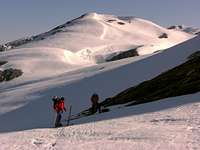
As it´s been may and due to the fact that Hinterbrand is only 1000 m high, there was no snow. So we had to fix our skis to our backpacks and set off on the forest road through the wood in the direction to Stahlhaus. The Stahlhaus trail is signposted and marked so there are no difficulties to find it. After a while we reached the ski slopes of the Berchtesgaden - Jenner ski area. The trail gets steep there and follows the ski slope up to the saddle between Jenner and Hoher Göll. It was not until we reached the second section of the skilifts that we could strap our skies to the feet and set off on the mellow and smooth spring snow which covered still the upper parts of Jenner area.
After leaving the ski area we traversed to Torrener Joch and Stahlhaus.
This comfortable and nice mountain hut lies exactly behind the German - Austrian border on the Austrian side of Torrener Joch, a broad meadow saddle between Hoher Göll and Schneibstein. One quick view revealed to us that there was still sufficiently snow lying on the slopes of Schneibstein, our first ascent tomorrow morning, though at Torrener Joch there were the first snowfree meadow patches and the first scattered crocus blossoms.
There were only about 10 people, including us, who wanted to venture out for the Große Reibn. We had the usual pre-hike chats during our nice dinner
and went to bed early.
Second day
The big one! About 2200 m of altitude difference. About 10 hours to go.
The alarm clock rang at 5 a.m. and we get started at 6 a.m. after a good breakfast. The skys were clear and the snow - thank God - was frozen. So we proceeded rather easily up the northern slopes of Schneibstein and one hour after we left the hut (1733 m) we reached Schneibstein summit (2275 m) and the morning sun.
What a view: to the west is the awesome rockwall of Watzmann, to the south the nearly endless plateau of Hagengebirge, our next aim for the day.
The descent from Schneibstein to Windscharte was quickly done and quite enjoyable.
Then there was the next ascent to our second summit, Schlunghorn (2203 m). Its south ridge is the entrance gate to the karst plateau of Hagengebige, which layed wide and heavily snowcovered in front of us. The Schlunghorn descent to Hagengebirge is quite dangerous because the south ridge, though you can do it with skies, is steep, narrow and has a nice little rockwall to your left and a wrong turn is not advisable at all .....
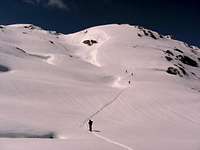
The snow was still frozen when we arrived the northern part of Hagengebirge. Crossing Hagengebirge means a lot of ups and downs at a hight of about 2000 m, traversing the gentle east slopes of Kahlersberg first, the highest summit of Hagengebirge. It was a very pleasant walk on skies through a white, hunchbacked landscape with marvellous views to the east and south. It was like gliding through a dreamland ...
After passing Kahlersberg we crossed a low saddle, called Lengtalschneid and reached the southern part of Hagengebirge. Slowly, the southern rim of the karst plateau get nearer and nearer and at last we started our ascent to the third summit of the day, called Jagerbrunntrog (the huntsmen spring).
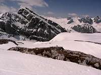
This summit stands high above the Blühnbach valley to the east and the valley of Königsee to the west. Hagengebirge is linked to Steinernes Meer with a small rock ridge, bearing the summits of Teufelshörner.
We had a well deserved break at Jagerbrunntrog and started our traverse of Teufelshörner. There is a steep chute at the western side of Jagerbrunntrog, called Eisgraben (ice chute). It was a tedious descent because the whole chute was filled up with the rest of an enormous avalanche and the snow was really bad. I "kissed" the ground several times. At the end of the chute you have to climb down some rocks, not very difficult but a nasty piece of work with the skies on your shoulders.
Traversing the Teufelshörner to the west (and high above the Königsee) was much more fun and we ended the first part of our day at the starting point of the long ascent to Funtenseetauern (2578 m), the huge summit, which stand between us (at about 1800 m) and our shelter for the next night, the Kärlinger Haus (1600 m).
Before starting the ascent we had a late lunch and a little nap in the now very warm sun. The first part of the ascent was really exhausting because of the heat, the mellow snow and the steep route. But after half an hour and above the timber line there was a slight cool breeze, better snow and the skitrack wasn´t very steep any more.
Higher and higher we climbed and the views, especially to the south and the north, were getting better and better. At last we arrived at the summit slope of Funtenseetauern, a southeastern exposed slope and we were not shure about avalanche conditions. There were some fresh little snow slides to our left. Finally we decided to do the ascent and it was o.k. There was a party of four ahead of us, too, and they had obviously no difficulties.
Our well deserved break on the summit offered a wide and marvellous view over the whole area and was worth the ascent.
And the best was yet to come: downhill to Kärlinger Haus. A wonderful descent in mellow corn snow, interrupted only once by a traverse of a very steep slope. We caused some fresh snow slides while traversing - quite a tense situation.
Arriving at Kärlinger Haus some other group had yet started a fire in the kitchen and we had hot water available for our pasta. Unfortunately the kitchen was poorly equipted so the 15 people in about five different parties had quite a difficult time to arrange dinner.
Kärlinger Haus is build in a depression and this depression is known as the coldest spot in Germany. They have measured about -48 degree centigrade in January. Thank God it was not so cold this night.
Third day
Another brilliant morning with blue skies and crisp snow. We stood up at 6 a.m. and after a quick breakfast we left the hut behind us for our traverse of Steinernes Meer.
First we went up through thin wood to a saddle called Toter Hirsch (dead deer). I don´t know where this name is derived from.
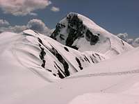
There surely was no dead deer but the gently mounting plateau of Steinernes Meer and the huge summit of
Großer Hundtod (another dead one, this time its a dog, but why ???) in front of us.
Ascending slowly these gentle slopes means gaining better and better views of the summits of Steinernes Meer and views to the north, to Hoher Göll, Hagengebirge, Schneibstein, where we get started a few days before.
The ski track arrives Hundstodscharte, a saddle south of Hundstod summit where we made a first break and had great views to the southwest.
An easy traverse leads to Dießbacheck on the westside of Hundstod and to the still shadowy western slope down to Hochwies valley. What a wonderful downhill fun ... Thank God the avalanches were already gone down the slopes into the valley.
After crossing the nice little valley the skitrack starts for its last ascent, up to Seehorn - Palfenhorn ridge. You have to gain about 400 m of altitude difference and its in the full noon sun. Well, I was quite relieved to reach the top of the ridge and it wasn´t hard to be convinced that the Seehorn summit was out of reach for this day.
Instead we traversed to Wimbachscharte and had our lunch there.
The last descent is the steep and famous Loferer Seilergraben, a broad chute that gets steeper and steeper with every turn you make. Its funny and a bit intimidating that you don´t see where this chute ends. Finally we reached the last very steep slope and once again we caused snowslides while skiing downhill. Sometimes the whole surface of the slope was in slow movement. It wasn`t that dangerous because it was only the uppermost 5 cm which went slowly crawling down. But it again was an impressive reminder that avalanche warning grade 2 does not mean no avalanches at all ...
Finally we reached Wimbachgries, the broad talus and scree fans at the beginning of the Wimbachgries valley. It is there where the snowline is in May, that means, a walk of about 5 km by foot with your skies back on your back.
Thank God there is Wimbachschloß halfway through this endless valley, a nice Wirtshaus with cool beer and a sunny terrace. We met there nearly all the other people who did the Große Reibn this weekend and we had a nice final chat about our adventure and about this great weekend and this gerat loop.
I surely will make it again!
Comments
No comments posted yet.