
-
 16788 Hits
-
 77.48% Score
-
 8 Votes
|
|
Route |
|---|---|
|
|
40.41620°N / 111.6669°W |
|
|
Snow/Ice Climb |
|
|
Most of a day |
|
|
Very Steep Snow/Ice |
|
|
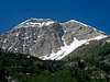
Approach
Take UT 92 east from the Alpine / Timpanogos Cave National Monument exit #287 off I-15. Continue up the Alpine loop, which is to the right at the junction to the Timpooneke Campground and Trailhead.
To get to the base of the couloir you have two main options. The first option is to climb up a gully into the Woolly Hole Cirque. This is the most direct, but involved scrambling up a gulley with loose rock. We went up the gully second from the right and followed it up until we encountered a cliff then we went right around the cliff and finished going up a smaller gully. The other option is to go up the north ridge. This climbs more gradually, but involves more bushwacking. It starts up the ridge using the Great Western trail, then you bushwack up the ridge through some aspen trees. A good game trail is past the aspen trees and will take you up until the ridge become more clear of trees and brush. Refer to the map for a better idea of the routes.
 |  |  |  |  |
Route Description
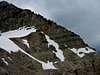
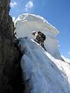
The route is straight forward once you start up the couloir. You want to keep your eyes and ears open for rockfall. You want to stay away from the runnel as most rockfall above you will get funneled down it. The couloir gets steeper as you climb it. It is mostly 40 to 50 degrees steep, but gets up to 62 degress at the very top. Once you get to the top there is a cliff and you go to the right to get up to the summit ridge.
DESCENT
There are many posible ways to get down. You can desend the west or northwest ridge down to the dirt road and then walk down the dirt road back to your car. This is the easiest way down, but requires a long walk down the dirt road. An other option is to come down the north ridge. The only tricky part is at 10,200' where you encounter a cliff that block acces to the rest of the north ridge. We decided to rap 80' off a tree to get down. In Kelsey's book he says there is a ramp up through the cliff to the ridge above. It also looks like you could scramble down and around. After getting down the cliff band you can go down the north ridge approach.
 |  |  |  |  |
Essential Gear
Crampons, an ice axe, and helmet are a must. Those with two ice tools will perfer them. Maybe a rope and a couple pickets. We only used the rope for the 80' rappel. Some webbing for rappeling if you take a rope.
Miscellaneous Info
If you have information about this route that doesn't pertain to any of the other sections, please add it here.
Scott - Jul 5, 2005 2:31 pm - Hasn't voted
Route CommentI have climbed the main gully up to Woolly Hole. It is steep, but you can climb it directly without using the ledge bypass in the Kelsey book. In 2000, there was an old frayed cable hanging of the highest pitch, but it would shred your hands without gloves. The cable may not exist any more, but either way, the wall is climbable with one short 5th class pitch.
Scott - Jul 5, 2005 2:36 pm - Hasn't voted
Route CommentAnother possible descent route is the Pika Cirque. You can descend (or ascend) the steep SE face of North Timp into the Cirque. There is a pond at the lip of the cirque and then a waterfall below. This section is tricky when snow covered, and you had better be good at self arrest. After bypassing the waterfall, you can descend very steeply into Woolly Hole. The route down below Woolly Hole is more tricky to find from above than below.
Ammon Hatch - May 13, 2007 9:44 pm - Hasn't voted
DescentAn excellent descent would be the Cold Fusion Couloir, as long as it is snow filled. It runs just west of the North Ridge. It took me around 15-20 minutes to descend the 2500 feet from the top of the couloir to the Timpanooke road. I'm fairly confident it would be faster to descend this and walk the extra distance to the bottom of the north ridge than it would be to descend the ridge itself.