
|
|
Mountain/Rock |
|---|---|
|
|
43.28592°N / 116.54155°W |
|
|
Owyhee |
|
|
Hiking |
|
|
Spring, Fall, Winter |
|
|
3130 ft / 954 m |
|
|
Overview
Guffey Butte is an interesting peak that rises immediately South of the Snake River in Owyhee County. Although it is only 3130 ft. it is still an exciting destination within 30 minutes of Boise. Because of its low elevation, dry climate, and easy access, Guffey Butte makes an excellent spring, winter, or fall, excursion. There is no shade so this hike would probably not be advisable in the summer.The butte consists of a large flat mesa with a smaller, more complex area of hills and canyons to the west. It is here that the summit is located, separated from the mesa by a small canyon.
 Guffey Butte
The area is characterized by smooth, grass and sage covered ridges and mesas interrupted by striking lava cliffs and towers. The most interesting tower is located on the northwest side of the mountain above a small canyon. Here a large black tower juts out from the side of the mountain rising probably around 150-200 ft. high. This is by far the dominant feature of the mountain as the summit is just a round hump with lava cliffs on the south side.
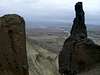
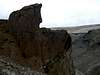
 The Pinnacle
The hike to the top is pleasant and has about 1000 ft. of elevation gain. Even though it is a somewhat easy hike there are plenty of opportunities to make it more challenging by hiking around the edge of the mesa or
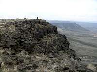 The Summit and South side
 View North
It is located about 20 miles southwest of Kuna, Idaho near Celebration Park. This area is also close to the Halverson Lakes.
History
The area has an interesting history beginning with the Oregon Trail. It was used as a landmark on the South alternate of the trail. Guffey Butte gets its name from G.M. Guffey who was an engineer friend of Col. William Dewey who help design the Silver City mining district.
This is one of the first Oregon Trail journal entries describing the butte.
William H. Frush, August 12, 1850
"[Guffey Butte] strikes Snake River at mouth of Dry Branch after coming down it for 3 miles. No bluffs on south side of River whare road strike. Thare is a bluff to the right of the road below whare it strikes river, ? mile, with a vary pirty tower or chimney by the side of it. Looks like a monument of Black Val's rocks... ."
Source
Getting There
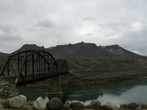
Being only about 30 miles from Boise, Guffey Butte is quite easy to get to.Traveling West on I-84 take exit 44 (Meridian Road) and turn South on Meridian Road toward Kuna. Follow the road into Kuna where it will make a 90 degree turn to the West. After a mile or so you will see an LDS church building on the right side of the road and just past this there is a sign directing you to the left to Swan Falls Dam and Dedication Point. Turn left here and continue south on Swan Falls Road for 10 or 11 miles until you come to the intersection of Swan Falls and Victory Lane. Take a right onto Victory which will head West and then abruptly North, intersecting with Warren Spur Road. Take a left here and head West down a a hill. Next, take a left onto Can-Ada road soon you will see a sign directing you to Celebration Park. Turn right on this signed road and follow the road to the park. The trail head is just west of the park near the old railroad bridge you must cross to access Guffey Butte.
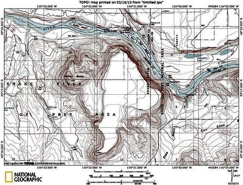 Map of Guffey Butte
Red Tape
There is a $2 day use fee for Celebration Park but it you park outside the park at the railroad bridge you won't need to pay the fee. If you want to camp at the park, which has pretty decent facilities there is a $5 fee. Neither fee is too steep so keep those options open.Take plenty of water especially if you plan on exploring the mountain for a long time or in warmer weather. There is no water on the butte itself but there is water available at celebration park or in the Snake River if you bring a filter.
I would recommend this only as a cold weather outing since this is desert country and there is no shade which can be pretty brutal in the summer months. There is also the possibility of encountering Rattlesnakes when the weather is warm. The butte rarely sees any snow accumulation because of it's low altitude so it works well in the winter for a snow free hike close to home.
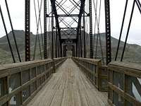 The Railroad Bridge
Camping
There are developed facilities at celebration park for a $5 fee as mentioned before but the Butte itself is on BLM land and offers plenty of excellent camping places, especially on the remote mesa east of the actual summit.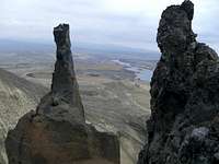
External Links
Here is some information about the area's interesting geology.Another geologic link.
Here's Idaho Summits trip report that got me interested in the area.
