
-
 5031 Hits
-
 73.06% Score
-
 3 Votes
|
|
Route |
|---|---|
|
|
29.17039°N / 13.50054°W |
|
|
Hiking |
|
|
Spring, Summer, Fall, Winter |
|
|
Half a day |
|
|
Exposed Hike |
|
|
Overview
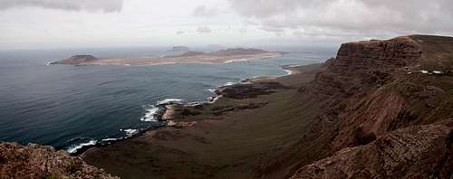
 La Graciosa seen from the panoramic trail La Graciosa seen from the panoramic trail |
The small village of Guinate is precariously balanced in one of the saddles which cut into the long ridge of Risco de Famara. It is home to a "Tropical Park" and one of the more interesting miradores, a lookout from which the Archipelago Chinijo can be admired. On both sides of the mirador big walls pile up promising even better lookouts on their tops. Both ridges can be climbed / hiked and the southern one is home to a panoramic trail which eventually leads to the craters of Quemada de Maguezand Los Helechos.
The ascent and descent to the top of Risco de Famara is marked and follows more or less well trodden paths but the broad top is completely pathless. The hike is not difficult but rather exposed during ascent and descent to and from the ridge. The ridge itself is broad so you can decide for yourself how much exposure you want to take. However, the ground is soft, like wet sand. GGetting too close to the edge can mean you break loose a nice rock avalanche onto whoever hikes Ruta de las Salinas 200m underneath. Take care for yourself and for others ...
The final ascent to the two volcanoes is very easy and follows a dirt road towards the top of La Quemada, then a short traverse to the summit of Los Helechos. The hike is unspectacular, not the views from and through the latter crater.
Getting There
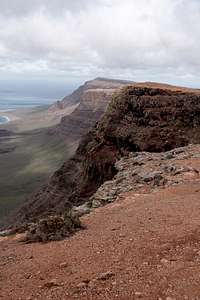
 Guinate Saddle as seen during the ascent
See the Los Helechos main page for the itinerary to Guinate.
Route Description
 GPS Track on Google Earth
- Start altitude: 350m
- Summit altitude: 581m
- Prevailing exposure: West
- Type: Exposed hike
- Protection: None
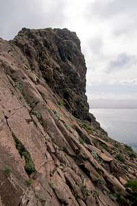
From the little parking lot near the Guinate community centre head on a dirt road out towards a ruined farm building at the base of Risco de Famara. The road ends a little before you reach the building but a narrow path gets you there. Pass to the other side where a narrow nearly unmarked trail starts to wind up to the crest of the Risco. It stays close to the edge and passes several platforms with wonderful views of the Archipelago Chinijo. After 20 minutes the top of the broad ridge is reached and a panoramic stroll takes you along the winding crest.
 Archipelago Chinijo as seen from the crest
Finally the crest ends in an abrupt drop towards a narrow saddle. A few hundred metres before this drop occurs, a narrow path heads down along the steep eastern slopes towards said saddle. There you can find an old artillery position from which you have a fantastic (if weather allows) view towards the Montañas del Fuego in the south. Just across the saddle wonderful basalt slabs can be seen, high above the base of Risco de Famara.
 |  |  |  |
From the saddle there are two possible alternatives: either stay on the narrow path which will take you to a dirt road heading up from the Guinate valley or stay on the crest and scramble across it. Both alternatives recombine a little later on the dirt road which then takes you to the plateau to the east of the risco.
 Monte Corona above the crater of Los Helechos, seen from La Quemada de Maguez
The road turns east and after a short while reaches a strangely shaped building. Here another road turns off to the left, heading for the western rim of Quemada de Maguez. The road ends and a pathless scramble takes you to the top of the volcanic crater. Now descend into a slightly pronounced saddle and head steeply up to the rim of Los Helechos, which you reach a little to the west of the summit. Circle the crater and return the way you came. Alternatively you can either use the road through the Guinate Valley or from the lowest point of the Los Helechos crater head back to Guinate on farming paths.