
|
|
Mountain/Rock |
|---|---|
|
|
36.03730°N / 75.34423°E |
|
|
Nagar/Baltistan |
|
|
Mountaineering |
|
|
Summer |
|
|
18973 ft / 5783 m |
|
|
Overview
Haigutum East is a minor snow peak on the south side of the Hispar Glacier, the fifth largest glacier in Pakistan. The peak forms part of the beautiful Bal Chhish range which is a dividing marker between the counties of Nagar and Baltistan. ‘Haigutum’ refers to the grazing area further east and is the last pasture on the southern side of Hispar. Despite Haigutum East’s modest height it is an interesting, challenging peak to climb in a stunning part of Pakistan’s Karakoram. The peak would make a great introduction to the mountains of Pakistan for those with suitable climbing experience looking for a mid-grade route. It may however be problematic for inexperienced climbers due to route finding difficulties through numerous seracs and crevasses. It would also be a good choice for acclimatisation for for higher peaks.
 from High Camp (5150m)")
Haigutum East is a short trek from Snow Lake, one of the most uniquely beautiful spots in Northern Pakistan. The trek to base camp is also a memorable one skirting the southern faces of the Hispar Muztagh which contains some of the most impressive peaks in the Northern Areas such as Kunyang Chhish, Trivor and Pumari Chhish. The Bal Chhish peaks along the southern side are also very dramatic. In my opinion the Hispar glacier is more inspiring than even the Baltoro glacier.
To the best of my knowledge the successful summit by me (Lee Harrison) and Peter Thompson was a first. We summited via a northern route from the Hispar Glacier in an Alpine style climb in two days making a high bivi at 5150m on route. The route is described here and the trip report is available here. No previous attempts have been made to the best of my knowledge and the south face remains unclimbed. This can be climbed from the Kero Lungma or Hucho Aichori valleys which extend north from where the Chogo Lungma glacier commences.

Climbing Conditions
The main challenge of climbing Haigutum East is finding a safe route through the maze of crevasses and seracs that litter the mountain. Many peaks in this area create the same objective dangers. Navigating seracs in the Karakoram is a dangerous affair compared to the Alps as avalanches are also numerous as seracs collapse in the summer heat. The rib that we climbed to the summit of Haigutum East via was evidently the only safe route on the north face. We first saw a photo of the Bal Chhish peaks in the book "Karakoram" by Shiro Shirahata published in 1991. Compared to his photo, in 2006 there were considerable more seracs highlighting the effects of rising global temperatures. P 6031 immediately west of Haigutum East has an even greater problem with seracs.
For many people visiting Pakistan's Northern Areas for the first time the warm summer's take time to adjust to. In Gilgit time temperatures regularly stay in their 30s during the summer and whilst it is cooler in the mountains it can still be uncomfortable at times. On days where there are no clouds a single layer will surfice and measures need to be taken to prevent sun burn. Weather can change quickly with fresh snow falling at any time in the year or heavy rains at lower altitudes. Come prepared for a range of climates. Nights are generally warmer during the climbing season compared to destinations such as the Pamir, Tien Shan or Napalese Himalaya and an early start when climbing is usually imperative to avoid soft snow in the afternoon. Often temperatures will not dip below zero at night time meaning snow conditions can be poor.


Getting There
From either Karimabad or Aliabad in Hunza first arrange a Jeep to the village of Nagar and then arrange a further one to the village of Hispar at the western end of the Hispar glacier. It is not possible to take a Jeep from Hunza directly to Hispar unless to driver is from Nagar as the road beyond Nagar is privately owned and only local Nagar drivers are allowed to use it. This unfortunately will put you in a poor bargaining position. Since there is no public transport between the villages having arranged a fee for your ‘special hire’ half the village will likely to join you for the journey without contributing to the fair. Public transport from Aliabad to Nagar leaves regularly as soon as vehicles fill up. They are likely to charge a little extra if you are carrying an expedition load on the roof. The road to Hispar sometimes blocks after rain and you may need to arrange porters on route, such as the village of Huru, as we had to.


A base camp can be reached along the northern side of the Hispar Glacier in around three days, give or take a day, depending on your pace, from the village of Hispar. If you have five or more porters then a guide is compulsory according to village rules (but not government rules). Hispar porters unfortunately do not have a reputation for being the most reliable so a guide may not be such a bad idea for this trek in. Porters also want more money per stage than Balti porters who often cross Snow Lake east to west. They want Rs450 per stage including wapasi (so Rs300in effect). Wapasi is what you pay to the porter to return to where the trek began if it has finished elsewhere. For every stage half a stage is paid in Wapasi. We paid 9 stages from Hispar to our base camp on the north side of the Hispar glacier beneath the peak of Hispar Sar. Porter rates may seem high to those who have previously visited Pakistan but rates have risen significanty in the last couple of years across all the Northern Areas. I personally had minimal problems with our porters and found them to be a very amiable lot. Only problem was that they nicked our abseil tat meaning that we couldn't try a nearby peak! (Ok, that's quite a big problem) They also seemed to be attracted to campsites with no water!
The trek along Hispar is a memorable one, even if you have spent a lot of time in Pakistan before. Whereas much of the Northern areas consist of arid valleys capped with white peaks, the north side of the Hispar glacier is lined with numerous meadows and great camping spots. The trek involves virtually no trekking on the Hispar glacier and follows ablation valleys for the majority of the way. From Hispar village the trail descends to the Hispar River where it crosses a bridge to its true left bank. A short distance further a small river that runs through a shallow gorge needs to be crossed. This can be problematic if you attempt it in the afternoon as I found out! Three glaciers need to be crossed on route. These are the Kunyang, Pumari Chhish and Jutmo glaciers in that order. The Kunyang glacier is the easiest to cross however the path descending on to the western side of the glacier is becoming particularly desperate. There are awesome views of Bularung Sar (7200m), Trivor (7720m) and the mighty Kunyang Chhish massif at the northern end of the glacier.
 Glacier")


Beyond the Kunyang glacier the landscape becomes less arid with numerous pastures. The Pumari Chhish glacier is easy to cross and also has stunning views north to Kunyang Chhish East, one of the most intimidating mixed rock faces that I have seen anywhere.
The Jutmo Glacier involves the longest crossing taking approximately two hours. Again there are memorable views north to Pumari Chhish peaks. Routes across the glaciers are marked by cairns but porters know the way anyway. The only place where the route descends on to the Hispar glacier is a short stretch between the Pumari Chhish and Jutmo glaciers. Here a ravine full of loose rock needs to be descended to the glacier. A short distance further east the steep path climbs back off the glacier.

Crossing the Hispar Glacier to reach Haigutum East on the south side of the mountain requires patience. Most of the glacier is covered in loose rock however there is a broad central strip of white ice with a network of ribs and streams. Finding an appropriate route to gaining and exit this central strip may time time. In 2006 a large stream ran along the north side of the white glacial strip however it could be crossed at narrow points via large rocks that bridging the gap. You may even want to don crampons in order to take a more direct line through this central part.


Haigutum East can also be easily reached from the south although I have not personally done so myself. From Skardu or Shigar a Jeep can be arranged to the village of Arandu from where it is approximately a three day trek up the Kero Lungma valley which extends north from the start of the Chogo Lungma glacier. A more adventurous way to reach the southern aspect of the Bal Chhish would be to trek along the Hispar Glacier, cross the Nishik La (around 5200m at a guess) (La = Pass in local Balti language) then descend down the Kero Lungma glacier. This route looks perfectly feasible and you will probably be one of the few people to have crossed the pass.
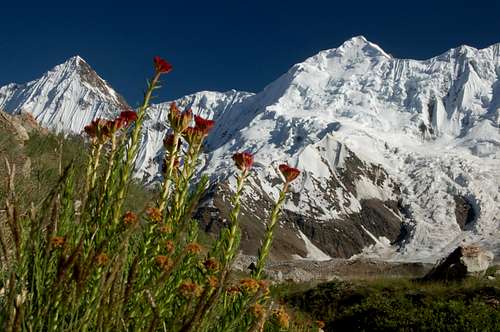
Flowers were numerous in July at our base camp. Haigutum East rises in the background from the south side of the Hispar glacier
Travel to the Northern Areas
Islamabad is the nearest international airport with flights arriving from around the world. Gilgit is the largest town in the Northern Areas served by regular transport from the north and south.
Domestic flights
PIA fly daily between Islamabad and Gilgit tickets can either be booked via their ticket offices or via their website. One-way fairs are currently Rs1590 with little discount for return trips. During bad weather planes may be grounded at short notice. Availablity is also a big problem. There are also daily flights to Skardu which operate a higher percentage of the time.
Buses
Buses run daily between Rawalpindi's Pir Wadhai bus station and Gilgit, and vice versa. Buses leave throughout the afternoon and arrive mid-morning next day. Book tickets in advance if poosible to avoid a bone jarring, sleepless ride on the back seat. Travel along the KKH is anything but predictable and landslides, mudslides, rock fall and even avalanches can sever it for hours, days or weeks at a time. Due to Tribal tensions in the Kohistan buses were travelling in convoy for a significant stretch of the journey further lengthening an already long journey. NATCO and Masherbrum both run buses daily with a limited number of seats available at student discount.
The Northern Areas can also be reached from China with the trip from Kashgar to Sost taking 2 nights with an overnight stop in Tashkurgan. Hi-Ace vans ply the route between Sost and Gilgit throughout the day leaving as soon as they are full. There is now a direct bus between Tashkurgan and Gilgit, however, if travelling from China, it is better to buy a ticket to Sost only then take local transport to Gilgit as the international bus sits in the customs yard at Sost for a couple of hours while luggage is checked before continuing to Gilgit.
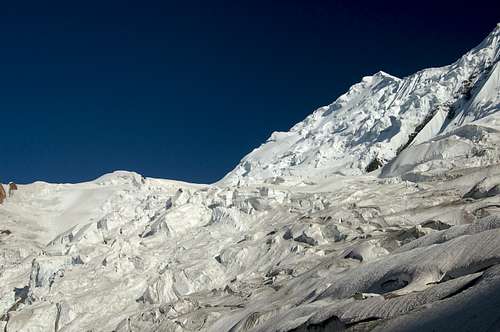
Haigutum East's north face from close to the base of the mountain
Red Tape
Permits
No permit is required to climb the mountain due to it being under 6500m. The peak is not in a restricted area and no permit is required to visit the Hispar Glacier. A liaison officer is also not required.
Visas
A valid visa is required. Visas are NOT issued at the airport and must be obtained prior to arrival. Some embassies such as those in Central Asia are reluctant to issue visas and advise you to obtain them from your home country. A single-entry tourist visa is valid for 3 months from the date of arrival in pakistan and for 6 months from the date of issue. Some visas are only valid for 3 months from the date of issue so check if necessary when applying. Visa prices vary. Americans pay the most for their visa whilst Japanese get theirs free! Visa extensions and reentry stamps used to almost impossible to obtain however the process has become remarkably easier in the last few years. Gilgit DC is a good place to try.
Accomodation & Camping
Hispar Village
There is no accomodation in Hispar village. The old rest house fell in to disrepair and is now closed. Beast bet is to camp on the outskirts of the village. Don't expect much privacy!

Hispar Glacier
A base camp can either be made on the north or south sides of the Hispar glacier. The north side has numerous grassy areas suitable for large groups between the Jutmo and Khani Basa glaciers at a spot called Haghura Shanga Liahung (spellings seem to vary). Water is slightly silty but not a major cause for concern. I would opt for a base camp here if you plan to be in the area for a while as it is far more pleasant. To reach the Bal Chhish range however will involve a two to three hour crossing (depending how lucky you are with route finding) of the Hispar glacier. For those looking to rough it a bit more a base camp on the southern side of the Hispar glacier is perfectly feasible although there are no pastures so you will be sleeping on ice. Water here is clear.
Good camping areas on route to base camp are also numerous. The best of the these are Bitamal to the east of the Kunyang glacier, Dachigan a few kilometres further east, and a spot close to the west bank of the Jutmo glacier.
Views from high camp (5150m)
 with Snow Lake in the distance")


Maps
The height of Haigutum East varies wildly depending which map you are looking at. The Swiss map marks the peak as >6100m which it certainly isn’t. The AMS Shimshal map shows the area however as does not indicate a height and is poor quality. The best maps for the area are undoubtedly the Russian maps which are available in both 1:50,000 and 100,000 editions. Nearly all peak heights in the area have been surveyed properly and the detail is excellent. Haigutum East is marked as being 5783m which is close to our own altimeter readings. The other published height is 5952m, as quoted in Shirohata's Karakoram book.
Russian 1:100,000 map Russian 1:50,000 map AMS NJ43 15 map (Shimshal) Schematic map of Hispar area