
|
|
Mountain/Rock |
|---|---|
|
|
36.39185°N / 74.71604°E |
|
|
Hunza |
|
|
Mountaineering |
|
|
Summer |
|
|
24239 ft / 7388 m |
|
|
Overview
Ultar II (also known as Ultar, Ultar Sar, and Bojohagur Duanasir II) is the most south-easterly major peak of the Batura Muztagh, which constitutes the western end of the main Karakoram crest. The mountain lies on the border between the district of Hunza to the south and Gojal to the north. While not being the highest peak in the Batura Muztagh it is one of the most impressive due to its elevated position above the Hunza Valley and also because of the mountain’s shear steepness. Ultar II is the main peak of the two summit massif of Bojohagur Duanasir. The other summit is Ultar I or North (also sometimes called Ultar West, also known as Bojohagur Duanasir), which is marginally lower at 7329m. The lower peak is actually northwest of the main peak explaining the name discrepancy. It can only be assumed that whoever named the higher peak the no. 2 peak was unaware that it was marginally higher or viewed the massif from the SW and simply named the peaks from left to right. The main summit is believed by local myth to be where a fairy queen once lived in a crystal palace.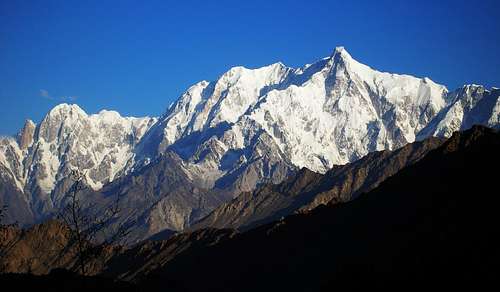 Ultar II
Ultar II is a difficult and dangerous mountain to climb with significant avalanche risk. Between 1986 and 1996 there were more than 15 expeditions to the mountain from six or seven countries. This is an unusually high amount for a Karakoram peak of this size and difficulty. Despite the high volume of attempts there was no summit until 1996 with only a significant number of fatalities to show for their efforts. The majority of attempts on the mountain were made from the south and west sides with the long south ridge being the most popular. Attemepts have also been made from the north but have largely been futile due to the significant objective danger. The Western peak had been previously climbed in 1984 by three Japanese climbers.
1996 bought not one but two successful ascents of the mountain via different routes. The first ascent was made by Akito Yamazaki and Kiyoshi Matsuoka from the Japan Alpine Club Tokai Expedition. The pair climbed the southwest side of the mountain via the avalanche prone Ultar Glacier in an almost alpine-style fixing 450m of ropes on the lower half of the ascent and using a few fixed ropes from previous expeditions higher up. Having left advanced base camp on 3rd July they reached the summit on the 11th. The eight day ascent was largely due to the mountain’s technical difficulties than anything else. Having summited, the pair’s luck took a turn for the worse. While descending the following day the weather deteriorated and the pair was forced to bivouac in their tent at 6000m for the next five nights with hardly any food or water. On the 17th the weather finally improved and they continued their descent and reached advanced base camp on the 19th – sixteen days after first leaving it. The following day Yamazaki began to feel sick with violent stomach ache. Next day his condition worsened and he sadly died at 11pm before a helicopter could evacuate him. Matsuoka’s fate was no better as he died only a year later while attempting the nearby rock spire of Bubuliomoting (Lady Finger). Yamazaki was only 28 when he climbed Ultar, Matsuoka only 24. The Japanese Alpine Journal Report is available here.
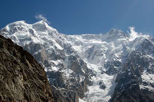
 Avalanche down the Ultar Glacier on the SW Face
The second ascent was made by a Japan Kathmandu Club Expedition via the south ridge on 31st July 1996. The climbers fixed 4000m of rope from 5200m to 7300m. Leader Ken Takahashi along with four other climbers Masayuki Ando, Ryushi Hoshino, Waltaru Saito and Nobuo Tsutsumi made the summit. This was Ken Takahashi’s third attempt on the mountain after failed attempts in 1986 and 1993.
The Southeast Pillar (or Hidden Pillar) of Ultar rises 3000m and has been referred to as the ‘Walker Spur of the Karakoram’ by some. The crux is most likely the rock barrier around 7000m however nobody has attempted the upper half of the route. To date there have been two attempts (that I am aware of), both of which have ended in failure relatively low down the route. A third attempt is due in 2007 by Colin Haley and Jed Brown.
With current Ministry of Tourism promotions Ultar is comparatively very cheap to climb at present as are all peaks in the Batura Muztagh.
  View from Karakoram Highway from between the villages of Passu and Gulmit. |
Climbing History
|
Year |
Climbing Party |
Outcome |
|
1985 |
Kiki de Pablos and Jose Luis Zaloaga (Spain) |
Reconnoitred southern aspect of Ultar and Bojohaghur Duanasir. After three days of exploration they decided there were too many falling stones, seracs and avalanches. They did climb a 5900m peak that descends to the SW of Bojohaghur Duanasir. |
|
1986 |
Japanese-Pakistani-American expedition led by Toshio Narita |
North face attempt from the Gulkin glacier. Established camp 1 (3900m) above BC (3150m) but this was avalanched and the team decided to retreat and try the south face. 5500m was reached but the attempt was halted as the route was considered too dangerous due to falling stones and ice. |
|
1990 |
Japanese expedition led by Tsuneo Hasegawa |
Reached 7020 on south ridge but were halted by deteriorating weather and threatened frostbite. |
|
1991 |
British-American expedition |
Victor Saunders (British) & Steve Sustad (American) Attempted slating route across the SE Face starting low down on the Cunus Glacier and heading for upper section of east ridge. Broken crampon and broken ice axe forced a retreat after 3 days. Mick Fowler & Crag Jones (both British) attempted south ridge. Climbed Alpine style. Reached a high point of 6500m but then descended due to bad weather. Previously the pair had made the first ascent of Hunza peak (6200m). |
|
1991 |
Japanese expedition led by Tsuneo Hasagawa |
Attempted south ridge (as in 1990). Ascended to camp IV (6500m). Attempted to descend to camp 1 (4900m) for a rest but were avalanched from 5350m to 4000m to their deaths. |
|
1992 |
3 man Japanese team led by Toshio Narita |
Attempted SE Pillar from Ahmed Abad Glacier. Reached high point of 5400m but were forced to descend as felt the route was unclimbable in the poor conditions and bad weather. |
|
1993 |
Norwegian team |
Attempted route from Hassanabad Glacier via east face & south ridge. Bad weather throughout. High point of 5800m reached on east face. |
|
1993 |
British/American expedition led by Julien Freeman-Attwood |
First attempted a route on the north side but retreated from a high point of 4600m due to the icefall being too broken to continue. Attempted a route on the SE pillar from the Sikardu Glacier. Ed Webster and Julien Freeman-Attwood, having linked up with the Saunders/Sustad traverse after 400m, backed off the route due to avalanche risk. Caradoc Jones and Stephen Read then attempted the same line and Sustad and Saunders had tried previously but gave up amid hard black ice and rock fall. Freeman-Attwood and Webster then attempted a new route from the Sikardu glacier to the East ridge. Havng gained the East ridge at 6000m they concluded that they had little chance of making a successful ascent and descended. |
|
1993 |
Japanese Expedition led by Ken Takahashi |
Attempted the entire south ridge starting from the village of Altit near to Karimabad. Yozoburo Kurosaki fell to his death at 6900m when a damaged fixed rope parted and the expedition was abandoned. |
|
1995 |
Akito Yamazaki and Kiyoshi Matsuoka, Japan Alpine Club Tokai Expedition |
First ascent of the SW face fixing only 450m of rope on route. Reached summit 8 days after leaving ABC. Descent took another 8 days to descend due to bad weather. Yamazaki died soon after following violent stomach ache. |
|
1995 |
5 member Japan Kathmandu Club Expedition led by Ken Takahashi |
First ascent of the south ridge. Siege style with 4000m of fixed rope. |
|
2005 |
Yannick Graziani & Christian Trommsdorff (French) |
Attempted SE Pillar from the Gurpi Cwm in October reaching a point halfway up the pillar just below 6000m (a 1600m ascent). Managed two smaller peaks, one being 5480m, Alpine TD+ |
| 2007 | Colin Haley & Jed Brown | Declined to attempt the SW (Hidden) Pillar |
Getting There
 Ultar from the KKH
Whichever way you approach Ultar II the walking distance is relatively short by Karakoram standards due to the mountain’s close proximity to the Karakoram highway. Private Jeeps are also easy to arrange in Gilgit, Karimabad and Gulmit although most are short wheel base. Just ask around and a driver will soon appear.
The South-West Side
From the south Ultar meadow (3270m) can be reached from Karimabad in around three hours via the steep, narrow Ultar valley. The base camp usually placed on the Ultar Glacier at around the same height. Even if you are not a climber Ultar Meadow is a lovely spot to trek to with rewarding views of the Ultar massif as well as Hunza Peak (6270m) and the rock spire of Bubli Motin (6000m). Even better views can also be had from Hon pass (4257m) above Ultar Meadow. The trek to Ultar Meadow isn’t the easiest as the ‘trail’ is becoming increasingly eroded. The granite walls that line the way are incidentally some of the most easily accessible quality rock in the Karakoram.
 Ultar I (left, 7329m) and Ultar II (right, 7388m)
Karimabad is easy to reach. From Gilgit there are regular Hi-Ace minivans that depart from the main station once full. The vehicles are a bit of an uncomfortable ride as four people are packed in each row although if you are a woman or with a woman then you might get the front seat which is better. You can usually put a fair amount of gear on the roof for a small extra charge. Returning, the only public vehicles that depart Karimabad for Gilgit leave early with the last one around 7am. After that, head down to Aliabad and catch a lift there. There is no transport direct to Karimabad from the north so get off on the KKH at the Karimabad turn-off and wait for a vehicle.
 Nearby Bubuliomoting (Lady Finger) (left, 6000m) & Hunza Peak (right, 6270m) from Ultar Meadow Nearby Bubuliomoting (Lady Finger) (left, 6000m) & Hunza Peak (right, 6270m) from Ultar Meadow |
 Diran 7300m) from Ultar Meadow Diran 7300m) from Ultar Meadow |
The South-East Side
The south-East side of Ultar is accessed via the Gurpi Glacier.
The North Side
Those wishing to see why nobody has tried the north face can reach it via the Gulmit glacier from the village of Gulmit on the Karakoram Highway. Gulmit is just as easy to reach as Karimabad due to Hi-Aces regularly departing Gilgit for Sost and Passu further north throughout the day until about 4pm.
Broader information on reaching the Karakoram is available on my Karakoram page.
Red Tape
 Ultar I & II above the Ultar Glacier
Royalty Fees
The Ministry of Tourism has decided to maintain the 10% reduction in mountaineering royalty fees for peaks above 6500m in the Gilgit region (excluding Spantik) during 2009 in an attempt to attract more expeditions to the Karakoram. Ultar II falls falin the boundries of the Gilgit region.
Royalties per expedition are based on a party of 7. Persons additional to this number will be subject to an additional royalty fee.
Note: These rates are only for the Gilgit region of the Karakoram which includes Hunza and Gojal (Upper Hunza).
Royalties for other areas of the Karakoram are 50% the normal rate. See the Karakoram page which I am currently building for details...
No Liaison Officer is currently required for the Gilgit region!
This makes the mountain very cheap to climb since it is not in a restricted zone.
Current royalties are listed below for the Gilgit Region.
| Elevation | Normal Fee | Fee for 2009 | ||
| Expedition Royalty | Additional royalty per person | Expedition Royalty | Additional royalty per person | |
| 7501 - 8000m | $4000 | $500 | $400 | $50 |
| 7001 - 7500m | $2500 | $400 | $250 | $40 |
| 6501 - 7000m | $1400 | $200 | $140 | $10 |
| Up to 6500m | $1400 | $200 | No fee | No fee |
Peak royalties are only 5% the normal rate for a winter attempt although this is only for the masocists.
Visas
 Ultar II at sunrise from Ultar Meadow
A valid visa is required. Visas are NOT issued at the airport and must be obtained prior to arrival. Some embassies such as those in Central Asia are reluctant to issue visas and advise you to obtain them from your home country. A single-entry tourist visa is valid for 3 months from the date of arrival in pakistan and for 6 months from the date of issue. Some visas are only valid for 3 months from the date of issue so check if necessary when applying. Visa prices vary. Americans pay the most for their visa whilst Japanese get theirs free! Visa extensions and reentry stamps used to almost impossible to obtain however the process has become remarkably easier in the last few years. Gilgit DC is a good place to try.
Camping & Accomodation
 The Hunza Valley
The only place where there is a charge to camp is within a stone wall perimeter at Ultar Meadow where there are a number of level spots for camping. I don’t know the exact charge however it will be cheap. Cooked food is also available at a hut here in the summer months. Clear water is available nearby although water purification is recommended due to grazing sheep.
 The Ultar Massif above Karimabad
Karimabad has great hill top views and offers a better choice of accommodation than Aliabad below on the Karakoram Highway. In my experience the cheaper guesthouses close to a spot called ‘Zero Point’ are actually nicer places to stay than the midrange places which are geared more towards down-country Pakistani’s rather than foreigner. There are also a couple of pricy hotels for those who like the comforts of home. It’s quite easy to buy enough food for an expedition here and canisters for stoves can also be bought here. It’s even possible to get a beer in Karimabad but I’d strongly advice against the tinned pork for sale in some of the shops. This is what it looks like!
Gulmit also has plenty of accommodation although it is not as budget friendly as Passu further north, or for that matter as nice as Passu. The local shops also do not have as good a range of food as Karimabad or Gilgit so bring food from Gilgit if you are travelling south. If you are just planning to spend a night under the north face then Gulmit’ shops will suffice.
When to Climb
 Ultar I & II above the Ultar Glacier
The mountaineering season runs from June to September with July and August being the most popular months to climb in Pakistan. Outside these months snow can be problematic at high altitude. Bad weather can hit anytime of the year. It's currently very cheap to attempt Ultar II in winter however, considering how avalanche-prone the mountain is, this would be a very bold attempt to say the least!
Maps
 (L-R) Bubuliomoting( Lady Finger) (6000m), Hunza Peak (6270m), Ultar I (7329m) and Ultar II (7388m) from the SW
The best map by far that covers this peak is the Deutschen Alpenverein (DAV) topographic map of Hunza-Karakoram. Its scale is 1:100,000.
There is also an excellent 1:100,000 orographical Polish map of the Batura Muztagh that is worth tracking down.
Sheet 1 of the Swiss Foundation for Alpine Research Karakoram 1:250,000 Orographical Sketch Maps shows Ultar Sar. Despite the large scale these maps are popular for the Karakoram due to their general accuracy and extensive coverage of the entire range.
External Links
First Ascent Report from Japanese Alpine JournalMy Hunza valley album is available here
Jed Brown & Colin Haley's Hidden Pillar attempt - Trip report
quiver - Nov 11, 2006 7:40 am - Hasn't voted
name correctionOne of the first summiters' name is wrong. "Kiysh Matsuka" should read "Kiyoshi Matsuoka".
aaporik - Nov 13, 2006 1:35 am - Hasn't voted
correctionGuiver, thanks for correction.
quiver - Nov 23, 2006 9:45 am - Hasn't voted
Re: correctionOK, let me point out 2 other typos: "Tsuneo Hasagawa" -> "Tsuneo Hasegawa" "Slato Wataru" -> "Saito Wataru" And as for this part: > the Japan Kathmandu Club, Tsutsumi Nobuo, Ando Masayuki, Slato Wataru and Hoshino Ryushi Tsutsumi, Ando, Slato(Saito) and Hoshino are all family names, so switching the order of family and given names will make your article more consistent. Anyway, Ultar is so closely related to the Japanese. Thanks for your great work, aaporik!
Corax - Jan 3, 2007 8:18 pm - Voted 10/10
ContradictionsThere are a lot of contradictions on the page and it's obvious it's a cut and paste job. Here's one example: The 7,388m Ultar Massif, one of the highest distinctive unclimbed summits in the world, has been attempted over the last 10 years by approximately 15 expeditions, mainly of Japanese origin. On the 21st of July (one report states the 11th) Akito Yamazaki and Kiyoshi Matsuoka reached the summit in an Alpine style push. Please correct the info. This is the reason for my low vote.
BigLee - Feb 26, 2007 6:01 pm - Hasn't voted
Re: ContradictionsAdopted and sorted! Like you say, former page was a complete cut and paste job - hence the contradictions.
Corax - Feb 26, 2007 6:40 pm - Voted 10/10
Re: ContradictionsYou should adopt some more of the Pakistani pages, if you have the time. Masherbrum is another junk page, where the maintainer has made the same kind of cut and paste job. Some info is cut from my pages, but he hasn't even bothered to make the links active. Great work on the Ultar II page.
BigLee - Feb 26, 2007 6:53 pm - Hasn't voted
Re: ContradictionsYeah, Ultar is a dangerous mountain and it's quite irresponsible to pretend you know what you are talking about by copy and pasting from other pages then guessing the rest. I probably will adopt Masherbrum at some point. I've got absolutely no photos of the mountain though due to bad weather when I was on the Baltoro Glacier. Don't know if you have any?
Corax - Feb 26, 2007 8:58 pm - Voted 10/10
Re: ContradictionsDon't know if you have any? I have some, but I think they are quite bad. I also had bad weather most of the time when passing the peak. I'll have a look later.
Damien Gildea - Feb 28, 2007 12:09 am - Hasn't voted
AttemptsUltar has been attempted since 96. The French, Graziani and Trommsdorf, who have done some of the most significant superalpinism of recent years, attempted the Hidden Pillar. Likewise infamous Austrian Thomas Bubendorfer went to do it. The Hidden Pillar of Ultar is one of the great unclimbed objectives in world alpinism, just not as well publicised as others. A 3500m high arete, one day from the road. Jed Brown and Colin Haley have a Mugs Stump Grant to go there this year. D
BigLee - Feb 28, 2007 8:26 am - Hasn't voted
Re: AttemptsYeah, I've heard about the hidden pillar of Ultar and the French. Cheers for that. I'll update in the next few days. I'm back in the UK in a couple of weeks and will have a proper search in the Sheffield Mountain library for info then. Cheers.
Damien Gildea - Feb 28, 2007 12:29 am - Hasn't voted
Bubuli's ThroneBig, In the Getting There bit you may want to note that Lady Finger and Bubulimoting are the same thing. Also, there was a piece somewhere not so long ago about the spelling of Bubulimoting, but I can't remember where it was, sorry. The peak is meant to be the throne of Princess Bubuli, who waited for her prince to come back and marry her but he never did. Word is he got an IT job in an Indian call-centre. Anyway, there are various spellings but supposedly Bubuliomoting is the most correct. I used to call it Bubliomotin, so that was wrong too. I tried the NW face in 95 & 96 but got not very high. In 2001 in Karimabad I gave some Spanish guys some beta on the route and one of them was then killed on it by rockfall a week later.
BigLee - Feb 28, 2007 8:28 am - Hasn't voted
Re: Bubuli's ThroneThanks, I took the spelling off the Swiss map which I should have known would be wrong! I noticed the other week that the Swiss map has GIV as GVI!
Damien Gildea - Feb 14, 2008 11:10 pm - Hasn't voted
Typo - SE2007 - Brown/Haley. The Pillar is the SE, not SW.