
|
|
Mountain/Rock |
|---|---|
|
|
36.16425°N / 75.37810°E |
|
|
Nagar |
|
|
Mountaineering |
|
|
Summer, Fall |
|
|
21132 ft / 6441 m |
|
|
Overview
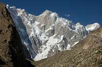
This is an unclimbed peak located in the heart of the Hispar Muztagh, one of the Karakoram’s most formidable sub-ranges. The mountain is situated east of the Jutmo glacier and west of the Khani Basa glacier, both of which extend northwards from the Hispar Glacier, the fifth longest in Pakistan. Despite a major Karakoram glacier being named after the peak it is by no means the highest mountain rising from the glacier. At the head of the Khani Basa glacier is Kanjut Sar (7760m), the third highest peak in the Hispar Muztagh and on its eastern aspect is Kanjut Sar 2 (6831m). North and south of Khani Basa Sar are the relatively minor North-Eastern Jutmo glacier and East Jutmo Glacier which extend from the main Jutmo Glacier. East face of Khani Basa Sar (center) rising above the Khani Basa Glacier
Because Khani Basa Sar is not visible from the northern side of the Hispar Glacier few people have set eyes on the peak. This may partly explain why the peak has received so few attempts. The lack of attempts is also no doubt due to the fact that the mountain offers no easy lines of ascent. I attempted a route from the East Jutmo glacier with Peter Thompson which appeared to me to have the most potential. Besides our attempt on the mountain there are no other official attempts. Throughout the Karakoram there have been many illegal ascents over the years and there maybe previous attempts on Khani Basa Sar that I am not aware of.
The route that I took up followed the East Jutmo glacier eastwards to a col at around 5600m. From here the attempt was abandoned as the southeast ridge which extended from the col to the summit looked extremely knife-edge and dangerous.
The mountain also appears to have some weird anatomy. From one perspective it appeared that the southeast ridge had two summits with a dip in the middle. Satalite mapping also shows this with a first peak approximately 80m below the higher with an approximate 200m drop between the two peaks.
One of the main problems with climbing Khani Basa Sar is the poor rock quality. Never have I encountered a mountain with so much rock falling off it. A number of couloirs on the southern side of the mountain would potentially make excellent routes were it not for the fact that huge amounts of rock continually falls down them. There is a particularly impressive steep broad couloir on the south-western aspect of the mountain that rises to a point just south of the main summit. Unfortunately this also receives a lot of rock fall. Due to poor rock quality trad climbing gear is virtually useless meaning the southeast ridge I declined to follow would offer little protection. Officially the Himalayan chain is slowly rising however I believe that Khani Basa Sar is slowly falling down!
Khani Basa Sar is a beautiful mountain however. The eastern face of the mountain is a steep mixed rock wall that extends from the glacier all the way to the summit without change in gradient and may have inspired the Khani Basa Glacier to be named after the peak. The southern and eastern aspects of the mountain also contain impressive rock buttresses and shear cliffs. Unfortunately I have not seen the northern side of the mountain and therefore cannot comment upon it. I imagine few people have visited the North-Eastern Jutmo Glacier.
When to Climb
As previously described, summer is a problematic time to climb due to falling rock. The best strategy to climb this mountain may be to try it around October time when temperatures have dropped, more ice has formed and rock fall is less likely. In these conditions some of the direct couloirs may be safer. This assumption is largely based on the attempt that Simon Yates and Andy Parkin made on Hispar Sar which lies directly south on the same ridgeline. The pair safely climbed the mixed southwest couloir in October 2004 but narrowly failed to summit the peak after a storm set in. Hispar Sar also consists of the same poor rock yet their attempt late in the season proved largely fruitful until the final chapter. Beyond October winter in the Karakoram is a bad place to be for a climber. Just as summers are hot, winters are freezing and avalanches are frequent. Many expeditions that have attempted winter ascents in the Karakoram have ended in failure or in some cases disaster. Upper section of the East Jutmo Glacier Upper section of the East Jutmo Glacier |
 Climbing towards the col at 5600m on the SE aspect of Khani Basa Sar Climbing towards the col at 5600m on the SE aspect of Khani Basa Sar |
 Ridge leading to Khani Basa Sar's summit from the SE col at 5600m Ridge leading to Khani Basa Sar's summit from the SE col at 5600m |
Getting There
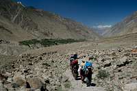
General information about reaching the Karakoram area can be found on the SP Karakoram page which I am in the process of building...From either Karimabad or Aliabad in Hunza first arrange a Jeep to the village of Nagar and then arrange a further one to the village of Hispar at the western end of the Hispar glacier. It is not possible to take a Jeep from Hunza directly to Hispar unless to driver is from Nagar as the road beyond Nagar is privately owned and only local Nagar drivers are allowed to use it. This unfortunately will put you in a poor bargaining position. Since there is no public transport between the villages having arranged a fee for your ‘special hire’ half the village will likely to join you for the journey without contributing to the fair. Public transport from Aliabad to Nagar leaves regularly as soon as vehicles fill up. They are likely to charge a little extra if you are carrying an expedition load on the roof. The road to Hispar sometimes blocks after rain and you may need to arrange porters on route, such as the village of Huru, as we had to.
 Jeep from Nagar to Hispar Jeep from Nagar to Hispar |
 Porters trekking out of Hispar village Porters trekking out of Hispar village |
 Southern face of Bularung Sar (7200m) Southern face of Bularung Sar (7200m) |
A base camp can be reached in around four days from Hispar village, give or take a day, depending on your pace and where base camp is placed. If you have more than five porters then a guide is compulsory according to village rules (but not government rules). Hispar porters unfortunately do not have a reputation for being the most reliable so a guide may not be such a bad idea for this trek in. Porters also want more money per stage than Balti porters who often cross Snow Lake east to west. They want Rs450 per stage including wapasi (so Rs300in effect). Wapasi is what you pay to the porter to return to where the trek began if it has finished elsewhere. For every stage half a stage is paid in Wapasi. I personally had no problems with our porters and found them to be a very amiable lot. Only problem was that they seemed to be attracted to campsites with no water! I am not sure how many stages it will be to base camps on the Jutmo and Khani Basa glaciers but I would guess that it will be somewhere between 9 and 12 depending where you camp. Porter rates and stages may seem high to those who have previously visited Pakistan but these have risen significanty in the last couple of years across all the Northern Areas. No doubt as a result of tourist numbers slowly starting to rise again.
 Trekking between the Pumari Chhish and Jutmo Glaciers Trekking between the Pumari Chhish and Jutmo Glaciers |
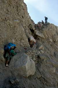 Negociating a tricky step during the trek to base camp Negociating a tricky step during the trek to base camp |
 Descending to the Jutmo Glacier Descending to the Jutmo Glacier |
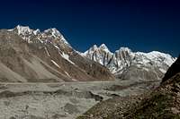
The trek along Hispar is a memorable one, even if you have spent a lot of time in Pakistan before. Whereas much of the Northern areas consist of arid valleys capped with white peaks, the north side of the Hispar glacier is lined with numerous meadows and great camping spots. The trek involves virtually no trekking on the Hispar glacier and follows ablation valleys for the majority of the way. From Hispar village the trail descends to the Hispar River where it crosses a bridge to its true left bank. A short distance further a small river that runs through a shallow gorge needs to be crossed. This can be problematic if you attempt it in the afternoon as I found out! Three glaciers need to be crossed on route. These are the Kunyang, Pumari Chhish and Jutmo glaciers in that order. The Kunyang glacier is the easiest to cross however the path descending on to the western side of the glacier is becoming particularly desperate. There are awesome views of Bularung Sar (7200m), Trivor (7720m) and the mighty Kunyang Chhish massif at the northern end of the glacier.
 The Kunyang Chhish massif from Bitanmal on the north side of the Hispar Glacier The Kunyang Chhish massif from Bitanmal on the north side of the Hispar Glacier |
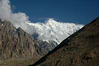 Trivor (7720m) from Bitanmal on the east side of the Kunyang glacier Trivor (7720m) from Bitanmal on the east side of the Kunyang glacier |
 Kunyang Chhish East above the Pumari Chhish glacier Kunyang Chhish East above the Pumari Chhish glacier |
Beyond the Kunyang glacier the landscape becomes less arid with numerous pastures. The Pumari Chhish glacier is easy to cross and also has stunning views north to Kunyang Chhish East, one of the most intimidating mixed rock faces that I have seen anywhere. The Jutmo Glacier involves the longest crossing taking approximately two hours. Again there are memorable views north to Pumari Chhish peaks. Routes across the glaciers are marked by cairns but porters know the way anyway. If heading up the Jutmo glacier to the western side of Khani Basa Sar then it is quickest to follow the white strips of glacier towards its center.
 The Jutmo Glacier with the Pumari Chhish peaks at the head of it The Jutmo Glacier with the Pumari Chhish peaks at the head of it |
 The Pumari Chhish massif above the Jutmo Glacier The Pumari Chhish massif above the Jutmo Glacier |
 Trekking towards the East Jutmo Glacier with Khani Basa Sar looming ahead Trekking towards the East Jutmo Glacier with Khani Basa Sar looming ahead |
The only place where the route descends on to the Hispar glacier is a short stretch between the Pumari Chhish and Jutmo glaciers. Here a ravine full of loose rock needs to be descended to the glacier. A short distance further east the steep path climbs back off the glacier.
For those wishing to also make an extended trek it is possible to trek up the Biafo glacier to snow lake, cross over the Hispar La and then descend to base camp taking around 8 days to do so. Transport will need to be arranged from Skardu or Shigar to Askole (same starting point for the Baltoro glacier trek).
Red Tape
Permits
No permit is required to climb the mountain as it is under 6500m (see table below). The peak is not in a restricted area and no permit is required to visit the Hispar Muztagh. A liaison officer is also not required. Higher peaks in the Gilgit area (excluding Spantik) do not currently need a liaison officer and the following Royalties are payable:
| Elevation | Normal Fee | Fee for 2008 | ||
| Royalty per expedition | Additional royalty per person | Royalty per expedition | Additional royalty per person | |
| 7501 - 7999m | $500 | $50 | ||
| 7001 - 7500m | $250 | $40 | ||
| 6501 - 7000m | $1400 | $20 | ||
| Up to 6500m | No fee | No fee | ||
Royalties per expedition are based on a party of 7. Persons additional to this number will be subject to an additional royalty fee.
Visas
A valid visa is required. Visas are NOT issued at the airport and must be obtained prior to arrival. Some embassies such as those in Central Asia are reluctant to issue visas and advise you to obtain them from your home country. A single-entry tourist visa is valid for 3 months from the date of arrival in pakistan and for 6 months from the date of issue. Some visas are only valid for 3 months from the date of issue so check if necessary when applying. Visa prices vary. Americans pay the most for their visa whilst Japanese get theirs free! Visa extensions and reentry stamps used to almost impossible to obtain however the process has become remarkably easier in the last few years. Gilgit DC is a good place to try.
 Peak to the Right of Khani Basa Sar Peak to the Right of Khani Basa Sar |
 Ridge along the southern side of the East Jutmo Glacier Ridge along the southern side of the East Jutmo Glacier |  Kanjut Sar 2 on the Khani Basa glacier Kanjut Sar 2 on the Khani Basa glacier |
Camping
Good camping areas on route to base camp are also numerous. The best of the these are Bitamal to the east of the Kunyang glacier, Dachigan a few kilometres further east, and a spot close to the west bank of the Jutmo glacier.The Jutmo glacier has numerous ribs that run parallel with the flow of the glacier and is covered in moraine. Setting up base camp on the glacier would not be a pleasant affair! The best camping spots on the western side of the mountain are found on the north side of the western end of the Eastern Jutmo Glacier where there are a number of flat spots supplied with clean water.
 Camping on the north side of the East Jutmo Glacier Camping on the north side of the East Jutmo Glacier |
 Bitanmal is a nice camping spot on route to BC Bitanmal is a nice camping spot on route to BC |  The Khani Basa glacier The Khani Basa glacier |
Maps
 East face of Khani Basa Sar
The only map that I have seen that accurately surveys the height of Khani Basa Sar is the Russian maps which are available in 1:50,000 and 100,000 editions. They are available online (ask no questions about copyright!) via the links below. It is these maps that I have based Khani Basa Sar altitude. The Russian maps are expensive to buy at around $75 and $50 respectively. There is also a series of Japanese maps that claim to have fully surveyed all peaks on their sheets however I have not seen these as they do not appear to be widely distributed. The Swiss maps are fine for general route finding and readily available. The two sheets cover the entirety and most people who have climbed in the Karakoram own a copy. Khani Basa Sar is stated as being c.6500m. The Swiss map is considerably better than the Leomann and AMS maps which are also readily available but not worth purchasing in my opinion. The Swiss map incorrectly calls the Jutmo the Yutmaru Glacier.
Russian 1:100,000 map
Russian 1:50,000 map
AMS NJ43 15 map (Shimshal)
Schematic map of Hispar area
External Links
There is no other info on the web about this mountain! The Alpine Club Himalayan Index also has no entries for Khani Basa Sar.Steve Razzetti Has some stunning photos of the Hispar Muztagh.