
|
|
Route |
|---|---|
|
|
27.82950°N / 86.77700°E |
|
|
Mountaineering, Trad Climbing, Scrambling |
|
|
Spring, Fall, Winter |
|
|
A few days |
|
|
Class 4 |
|
|
Class 4 (very exposed) |
|
|
Overview
The standard route up Hamugon is via the northwest ridge from Tengboche. This is an exciting half day climb from Tengboche.The route up the ridge from Tengboche is quite challenging and exposed in its upper 1/3. The route is borderline class 5, but the climbing is on scary grass ledges rather than rock and a rope might come in handy in places, though there aren’t many good places to set up a belay. The summit is adorned with prayer flags, probably placed by the monks in Tengboche. This isn’t a good route to try in bad weather or when the route is wet, snowy, or icy.
After the climb was finished, we noticed that the north slopes of the mountains may offer a slightly easier route than staying close to the ridgetop.
 Kessler on the ridge while climbing Hamugon (peak).
Getting There
The climb of Hamugon begins in Tengboche; an easy one day walk from Namche Bazaar.Namche Bazaar can be reached on foot from several directions. The two most popular routes to Namche Bazaar are from the trail from Lukla Airport or the walking route from Jiri and Bhandar.
As of December 2012, only Sita Air and Yeti Air (which are basically the same company) fly to Lukla. Namche Bazaar is two days on foot from Lukla, and most people spend one, two, or more days acclimatizing in Namche Bazaar before heading higher to other areas, which is a very wise move.
Be aware that flights to Lukla can only fly in good weather and that sometimes planes are grounded for days.
The walking route from Bhandar to Namche Bazaar takes 8-9 days plus a long day’s bus ride from Kathmandu. Twelve buses a day leave from Kathmandu and from Jiri usually transport can be found to Bhandar.
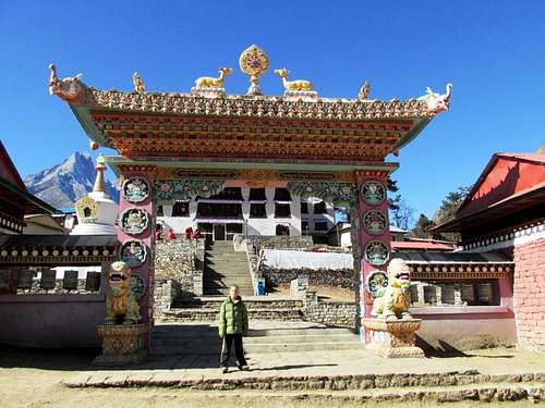 Tengboche Gompa, at the base of Hamugon.
Approach
From Lukla, the main trail heads north and down to Cheplung. From here the trail continues along the Dudh Kosi River and ascends to Ghat and Phakding. Most people spend the first night here, but if you have time, I'd recommend continuing another hour or two to Benkar. This helps spread business between places that are normally used as overnight stops and allows a quieter experience as well. There are a few nice waterfalls around Benkar as well.From Benkar, the trail crosses the river and a bridge and ascends gradually to Chumoa and Monjo. It is here that you will have to show your permit and this is the first of many checkpoints. Jorsale is just beyond and is the last town before the long, but fairly gradual climb to Namche Bazaar. About 2/3 of the way up is a viewpoint with your first views of Ama Dablam, Everest, and Lhotse.
From Namche Bazaar, consider a longer route though Khunde and Khumjung. The direct route is a heavily used (and often dusty) trail passing through Kyangjuma, Sanasa, Tashinga, Phunki Tenga and then up the final long climb to Tengboche. If you are feeling ill at all, Phunki Tenga is the lowest place to stay in the Khumbu. Tengboche has plenty of lodges to stay in.
Between Namche Bazaar and Tengboche, the spectacular Himalayan views really open up and you are rewarded with great views of Thamaserku, Kangtega, Ama Dablam, Lhotse, and Everest.
 Hamugon is the peak on the left. As seen from the trail to Tengboche, which is the place you will stay while climbing Hamugon.
Route Description
Because Hamugon is so obvious (the big dark pyramid rising above town), the route to the base is obvious. Hike along the ridge to the southeast towards the peak. There is a well beaten path along the ridge. Keep an eye out for Himalayan pheasants (we saw several).The trail narrows, passes a chorten, and climbs up to the first sub-peak (about 1/3 of the way up) which also has a chorten on top. It also has a large cairn on top and some really spectacular views. If you are short on time, this make a great diversion from Tengboche.
From this subpeak, the next 1/3 of the route follows a rough path that sticks close to the ridge. There is some nice and enjoyable class 3 climbing along the route. The route gets steeper as you climb.
The last 1/3 of the climb is much more difficult and exposed. It should only be done in dry conditions unless you are prepared for very technical terrain. The route becomes more difficult as you climb and you will find it very difficult to stay on the ridgetop. Several rugged sections of the ridge force you left and onto the grass covered steep face. The route to the summit is obvious, but there is some serious exposure along the route. A rope and technical gear could come in very handy, but there aren’t many places to set anchors since you are climbing on extremely steep grass.
Persevere up the slope. The final ledges were difficult enough that I had to leave the pack behind. Use extreme caution as there are some loose rocks. Also, take careful note of the route back down.
Once on the summit, the views are fantastic, but much of the spectacular Kangtega is hidden by a subsidiary ridge. The views of Everest, Lhotse and Ama Dablam are spectacular. On the summit are several rock monuments and many prayer flags.
After enjoying the views, return the same way, using extreme caution on your descent.
There are other peaks along the ridge and Hamugon is more of a sub-peak than an independent peak. The next peak along the ridge may be accessible by a tricky scrambling route, but anything beyond this is highly technical terrain for sure.
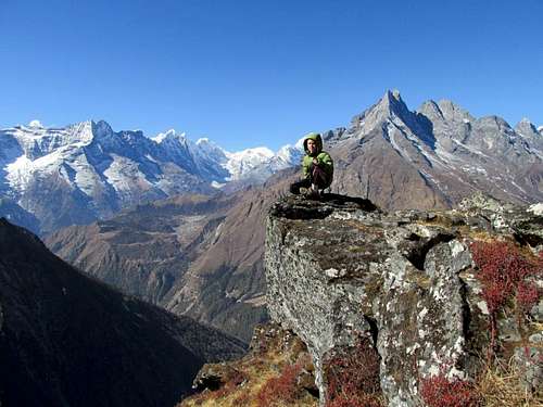
 Taking a rest on a rare flat piece of ground on Hamugon.
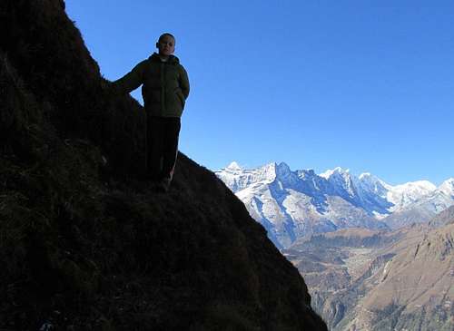 Kessler on the exposed grass ledges near the summit of Hamugon.