
|
|
Mountain/Rock |
|---|---|
|
|
27.82950°N / 86.77700°E |
|
|
Hiking, Mountaineering, Trad Climbing, Bouldering, Scrambling |
|
|
Spring, Fall, Winter |
|
|
14960 ft / 4560 m |
|
|
Overview
Hamugon is a nice little peak (well, at least by Himalayan standards it is “little”) above the famous Tengboche Gompa (Monastery). While most trekking and climbing itineraries recommend a rest day in Tengboche, Hamugon might prove just the thing for a “rest” day and makes a great acclimatization peak. It is certainly a recommended side trip in the Khumbu region, though it seems that few trekkers and climbers climb it.Despite being one of the lowest of the 12 peaks we climbed on our trip to the Khumbu, Hamugon was also one of the most challenging. It is more difficult than it looks. The first 1/3 or so of the climb is easy up to the little sup-peak with the little monument. The next 1/3 of the climb is more challenging and follows a class 3 ridge. The final 1/3 of the climb is an exposed climb up ledges covered with grass and is quite challenging. I would still rate the difficulty as class 4, but it’s scarier than any 4th class route than I’ve done in Colorado, for example. The route is borderline class 5, but the climbing is on scary grass ledges rather than rock. The climb was difficult enough that the climbing Sherpa/porter whom we were with would not make the climb and neither would the other porter. Only Kessler and I made the summit, but the climb was difficult enough that I had to ditch the pack for the final few ledges.
The views from Hamugon are absolutely fantastic. Nuptse, the huge south face of Lhotse, Everest, Ama Dablam, Thamserku, etc, etc. are all visible in all their splendor. Kangtega is close, but much of the view of it is obscured by a ridge.
Hamugon itself is more a sub-peakof Kangtega than an individual peak. You can continue along the ridge, but the next peak on the ridge looks like a very tricky scramble. The ridge after that is definitely technical and would be mini-expedition territory.
 Hamugon (foreground) and Kangtega.
Getting There
The climb of Hamugon begins at Tengboche. Tengboche can be reached on foot from several directions. The two most popular routes to Tengboche are from the trail from Lukla Airport or the walking route from Jiri and Bhandar.As of December 2012, only Sita Air and Yeti Air (which are basically the same company) fly to Lukla. Tengboche is three days on foot from Lukla, but most people spend one, two, or more days acclimatizing in Namche Bazaar, which is a very wise move.
Be aware that flights to Lukla can only fly in good weather and that sometimes planes are grounded for days.
The walking route from Bhandar to Namche Bazaar (one day below Tengboche) takes 8-9 days plus a long day’s bus ride from Kathmandu. Twelve buses a day leave from Kathmandu and from Jiri usually transport can be found to Bhandar.
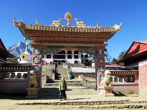 Tengboche Gompa, at the base of Hamugon.
Routes Overview
Northwest RidgeThe standard route up Hamugon is via the northwest ridge from Tengboche. This is an exciting half day climb from Tengboche.
The route up the ridge from Tengboche is quite challenging and exposed in its upper 1/3. The route is borderline class 5, but the climbing is on scary grass ledges rather than rock and a rope might come in handy in places, though there aren’t many good places to set up a belay. The summit is adorned with prayer flags, probably placed by the monks in Tengboche. This isn’t a good route to try in bad weather or when the route is wet, snowy, or icy.
After the climb was finished, we noticed that the north slopes of the mountains may offer a slightly easier route than staying close to the ridgetop.
 Upper slopes of Hamugon. The climb is much harder than it looks. It follows the ridge in front of the camera before traversing left onto the grass covered ledges just to the left of the ridge. The route stays close to the ridge, but on the grass covered ledges to the summit.
Red Tape
A Sagarmatha National Park permit is required - 1000RS (US $11.50)Bring a Passport and Passport size Photograph.
A Trekkers’ management system (TIMS) is also required and cost $ 20.
Most guesthouses and hotels in Kathmandu frequented by Westerners can help you obtain a permit, especially in Thamel.
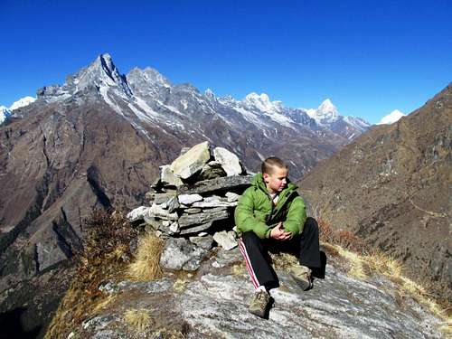 You must have a trekking permit to climb Hamugon. This is Kessler on the little sub-peak of Hamugon about 1/3 of the way up.
Camping and Where to Stay
You could camp along the trails, though I don’t know why anyone would want to since it wouldn't save much money and would isolate you from the friendly locals. Every village has several lodges for only a few dollars a night. Most (every one we saw) are clean and pleasant. All lodges serve food and snacks; so don’t bother with carrying any food along the trails. Hamugon is the peak on the left. As seen from the trail to Tengboche, which is the place you will stay while climbing Hamugon.
When To Climb
Mid September through mid May is the best time to trek and climb this peak. The monsoon is from June through mid-September, and this is not an ideal time to go because the trails are very wet and the lower forest are full of leaches, plus it rains every day and clouds usually obscure mountain views.October, November, March, and April are the most popular months, and the trail and lodges can be very crowded. In my opinion, December is the very best month. The weather is cooler than the most popular months, but it is less crowded and prices in Kathmandu are a bit lower. December is also a very dry month.
On our first trip we had 47 days in the region during late November and mid-January with only one bad weather day. On the second trip we had two days of snow in a four week period early December to early January.
The winter season (late December through February) is also a good time to go with few crowds and usually good, but cold weather, but you can expect to have some snow and ice on the trails. Remember that there are villages along all the trails, so if you had to sit out some bad weather, it’s not that bad.
The route up Hamugon is not safe when covered in a light dusting of snow. Snowy or icy conditions would make the climb quite technical.
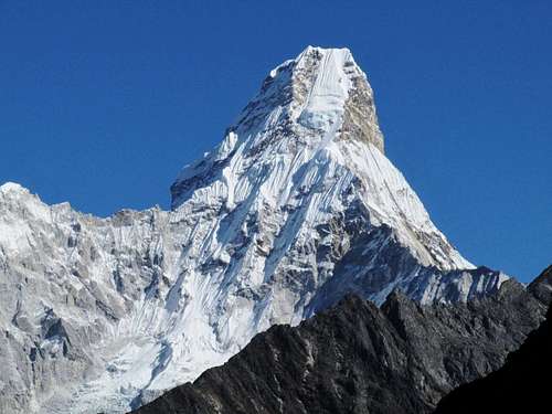 Ama Dablam as seen from near the summit of Hamugon as seen during great weather in December.
Mountain Conditions
CLICK HERE for the weather forecast for Namche Bazaar, which is just southwest of Hamugon and at 3440 meters/11,290 feet elevation.Averages for Tengboche at 3860 meters/12,669 feet elevation are below:
| Month | High (° F ) | High (° C) | Low (° F ) | Low (° C) | in. Rain | mm Rain |
| Jan | 39 | 4 | 16 | -9 | 0.51 | 13 |
| Feb | 41 | 5 | 16 | -9 | 0.94 | 24 |
| Mar | 48 | 9 | 21 | -6 | 0.91 | 23 |
| Apr | 54 | 12 | 25 | -4 | 0.98 | 25 |
| May | 57 | 14 | 30 | -1 | 1.14 | 29 |
| Jun | 57 | 14 | 37 | 3 | 3.74 | 95 |
| Jul | 57 | 14 | 41 | 5 | 11.02 | 280 |
| Aug | 57 | 14 | 39 | 4 | 10.43 | 265 |
| Sep | 55 | 13 | 36 | 2 | 5.51 | 140 |
| Oct | 54 | 12 | 28 | -2 | 2.83 | 72 |
| Nov | 46 | 8 | 19 | -7 | 0.35 | 9 |
| Dec | 43 | 6 | 17 | -8 | 0.08 | 2 |
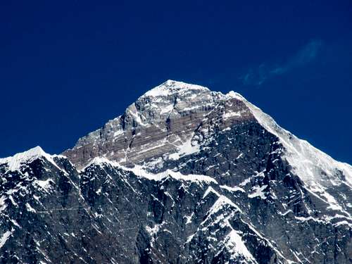 Everest as seen from near the summit of Hamugon.