
|
|
Route |
|---|---|
|
|
38.90390°N / 106.2969°W |
|
|
Mountaineering |
|
|
A long day |
|
|
class 2 |
|
|
Overview
This is an important route for peakbaggers because it is the easiest way to climb Harvard and Columbia together. On this route you will almost completely circle Mt. Columbia. At 14 miles round trip and a whole lot of vertical gain, it will also wear you out. Start early and pay attention to your route!
North Cottonwood Trailhead
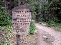 Wilderness Boundary
To reach the North Cottonwood Trailhead, measure from the junction of US 24 and Chaffee County 306 in the center of Buena Vista. Drive 0.4 miles north on US 24 to the junction of Chaffee County 350. Drive 2 miles west and turn right (north) onto Chaffee County 361 at the T. Drive another mile north and northwest to the next T and a sign for North Cottonwood Creek. Turn left (south) there. Follow this road (Chaffee County 365) briefly south then west into the forest. At mile 8.2, reach the North Cottonwood Trailhead, which is at the wilderness boundary. You are now at 9,900 feet.
Approach, i.e. Getting to the Top of Mt Harvard
Follow the South Slopes Route to the summit of Mount Harvard. If you reach the Harvard summit after noon, or if the weather turns stormy, consider returrning the way you came instead of continuing around to Columbia.Route Description
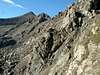
 Topo map
Follow the ridge off of Harvard, to the east. Descend to the left of Point 13,516, then continue in a southeasterly direction to about 12,800'. There is no need to descend all the way to the creek. Rather, contour at about 12,800' to the south. If you find the going very difficult, you are too high. Lose more elevation to get off the ribs and gullies.
The first time I did this route we tried to contour at a higher elevation, maybe 13,200'. That was a mistake. We thought we would be smart and save ourselves some lost elevation, but instead we wasted a whole lot of time on the steeper slopes beneath the ridge. The result was a long and arduous climb, lost clothing, and a delayed arrival on the Columbia summit. It grew dark long before we got back to the car. Even with good route selection, this is a long, round trip hike.
Finish your climb on Columbia's gentle, north or east slopes.
Descent
 Headin' home
After you reach the summit of Columbia, descend its west slopes to rejoin the trail at the bottom of Horn Fork Basin. Finding the trail down below is a little difficult, so plan your way while you are still high on the slopes where you can see everything. Some say the screen on Columbia's west side is miserable. Others consider this the easiest part of their day.
This route may be done in the opposite direction. However, that leaves you with a longer hike back to your vehicle and little opportunity to beat an early retreat.
Natasha - Oct 15, 2004 12:21 am - Hasn't voted
Route CommentI might add that low-cut gaiters for the lengthy hike down the scree on Columbia would lower one's frustration level.