
-
 5678 Hits
-
 79.04% Score
-
 10 Votes
|
|
Route |
|---|---|
|
|
38.90390°N / 106.2969°W |
|
|
Hiking |
|
|
Spring, Summer, Fall, Winter |
|
|
A long day |
|
|
Overview
The Southeast ridge approach to Columbia has many advantages over other routes and is worth considering if you plan to head up this great 14er. While it does take some time, this route provides outstanding views and solid footing. The beauty of this route is that there is no trail higher up and just a faint use path in the trees. So, this is a fun opportunity to practice route-finding. Plan for 12 miles and around 4500’ of elevation gain.Getting There
 Route Map
Enjoy a nice visit in Buena Vista (Go West on Hwy 24 from Colorado Springs or Hwy 285 from Denver, about equal distance from Denver or Colorado Springs). When you get to town, find the stoplight near the center of Buena Vista and go ½ mile north, then turn west on County Road (CR) 350 (Crossman Ave.). Continue on CR 350 for 2 miles and turn right onto CR 361. After nearly 1 mile, turn left onto CR 365 (dirt). Continue on this road for 3.4 miles to the marked trailhead on the right. This is a small trailhead, so don’t miss it. Parking is across the street on driver’s left, just before the trailhead.
Route Description

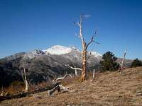
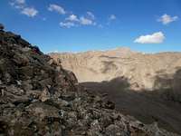
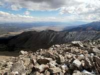
Take the Colorado Trail toward the Harvard Lakes. Around 10,000’ leave the Colorado Trail and Columbia’s southeast ridge into the forest. Your turn is marked by a cairn on your left and is easy to miss. The trail through the woods goes between great, faint and non-existent. As you start up through the woods you will find many small cairns to help you find the way. Again, the trail can fade into nothingness with downed trees lying across it – look for the cairns. We stayed to the right side of the ridge centerline with an occasional walk along the ridge. You will find it rockier near tree line with one small boulder field to cross. Once you break out of the woods you’ll find a area of dead but picturesque trees. While you may not see an established trail, your way ahead will be obvious. Take the ridge line. We tended to cut some of the repeated elevation gain by staying left of the ridge line. Around 12,800', there is a switchback on the ridge – now you can see the summit on the other side of Three Elk Creek Basin. As we traveled the ridge we occasionally went over the top of points, at other time we stayed left and lower on the mountain – pick what works best for you. There will be some times when you will go up and over rocks and boulders, hands were not really needed along the trek, but, hey, I made it. As always, the summit is the farther of the two high points you will see, but an easy walk. Remember to allow plenty of time for this hike. While only about 12.5 miles, route finding will add some time to your adventure. On the positive side, you will not see many other folks so you can truly enjoy the wilderness and views.
Essential Gear
• Outerwear appropriate to the season• Map, compass & GPS
• Colorado Gazetteer for road navigation
Other Stuff

You do enter the Collegiate Peaks Wilderness, so be sure to review current regulations and restrictions. Check with the US Forest Service for details.
A fun note, we followed a 30-head goat heard around the ridge (see picture). They moved along as we got closer, but the occasional young male had to stay back and check us out.