
-
 20030 Hits
-
 84.82% Score
-
 19 Votes
|
|
Mountain/Rock |
|---|---|
|
|
34.19450°N / 118.0623°W |
|
|
Los Angeles |
|
|
Hiking |
|
|
Spring, Summer, Fall, Winter |
|
|
4000 ft / 1219 m |
|
|
Overview: Part of a Lower Peaks Combo
Hastings Peak is a bump on a wonderful ridge connecting the saddle just north of Jones Peak (3,375’) with the Mt. Wilson Toll Road, a major hiker and biker artery in the San Gabriel front range. This peak overlooks beautiful Bailey Canyon and in turn sits below the range of peaks comprising the Mt. Wilson crest. Apart from Jones Peak, Hastings’ nearest neighbor is Mount Yale, about ¾ mile away. In fact, the hiking combo of Jones, Hastings and Yale makes for an excellent lower peaks hiking day.From low on the Bailey Canyon Trail, Hastings Peak actually looks “big and far away” although it is only about 4.25 miles from the Bailey Canyon trailhead.
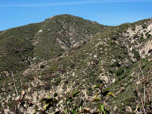 Hastings Peak seen from Bailey Canyon Trail, 2/17/07
Hastings Peak affords excellent views towards the Pacific Ocean and Catalina Island because there is nothing higher to impede views in that direction. Mt. Baldy is to the east, along with Mt. San Gorgonio and Mt. San Jacinto further on the horizon. Closer in, to the northwest and moving clock-wise, you eye Mt. Lowe, Mt. Markham, San Gabriel Peak, Mt. Yale and Mt. Harvard.
 Mt. Harvard (extreme right), Mt. Yale (just left of Harvard)
 L-R: Mt. Lowe, Mt. Markham, San Gabriel Pk from ridge near Hastings Peak 2/17.07
The recommended route to Hastings Peak is from the Bailey Canyon Park trailhead in Sierra Madre. Take the Bailey Canyon Trail 3.2 miles to the little saddle just north of Jones Peak.
 Looking down on the saddle (3300') north of Jones Peak
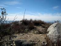 Summit area of Hastings Peak, 2/17/07
 The NW ridge along which Hastings Pk is situated seen from the north. Hastings Pk is the 3d bump from the right
An alternative route would be to start from the Mt. Wilson Trail trailhead, 1 mile east of the Bailey Canyon Park trailhead. Take the Mt. Wilson Trail about 2 miles to a “connector” trail that ascends in a southwesterly direction off the Mt. Wilson Trail. This connector trail is off to the left before you get to the helipad next to the Mt. Wilson Trail. In less than a mile, but with about 700 feet of gain, this connector trail gains the ridge coming from Jones Peak at a point less than a mile from your destination, Hastings Peak. This route is about 8 miles round trip with about 3,100 feet of gain.
Getting There
The recommended route begins at the Bailey Canyon Park trailhead, also known as Grove Park. It is situated within the city limits of Sierra Madre. From the 210 Freeway, exit at Santa Anita Ave. and go north. Turn left (west) on Grand View. Continue several blocks to Grove. Turn right (north) onto Grove and drive directly into the Bailey Canyon Park/Grove Park parking lot. There is a gate at the entrance to the park open “from dawn to dusk.” If you get there before the gate is open, there is parking along adjacent residential streets.For the alternate route starting from the Mt. Wilson Trail trailhead, exit the 210 Freeway at Baldwin Ave. and go north. When you come to a traffic light where you have to go either right or left, go left to the next light which is Baldwin Ave. Take a right and continue up Baldwin Ave. through the “downtown” area of Sierra Madre. Approximately 1/2 mile from the downtown plaza, take a right on Mira Monte. Go down about 1/3 mile and you will come to a small park on your left. Park anywhere in this area along Mira Monte. To get to the trail, walk up the paved road that goes north off of Mira Monte next to the park.
Red Tape
No permits are needed for this hike. Neither will you need an Adventure Pass or Golden Eagle Pass to park at either the Bailey Canyon Park or Mt. Wilson Trail trailheads as these trailheads are not located within the Angeles National Forest.Camping
There are no campsites/campgrounds within the immediate vicinity of this peak.When to Climb
All year round. However, clothe and equip yourself appropriately on the infrequent occasions when there is winter snow cover at this elevation.Mountain Conditions
Check forecast information for nearby Mt. Wilson in local newspapers or internet weather services. There is sometimes snow at elevations below 5,000 feet in the San Gabriel front range during the winter.Other Information
USGS 7.5 Topo: Mt. WilsonExternal Links
Sierra Club's Lower Peaks Committee Peak ListAngeles National Forest