Welcome to SP!  -
Mount San Antonio (Mount Baldy)
Mountain/Rock
Contribute 
 
Children 
 
[ 5 More ]
 
Geography
Parents 
Mountains & Rocks
 
Mountains & Rocks
 
Mountains & Rocks
 
Mountains & Rocks
 
Mountains & Rocks
 
Mountains & Rocks
 
Mountains & Rocks
 
Mountains & Rocks
 

Mount San Antonio (Mount Baldy)

 
Mount San Antonio (Mount Baldy)

Page Type: Mountain/Rock

Location: California, United States, North America

Lat/Lon: 34.28890°N / 117.6458°W

Elevation: 10064 ft / 3068 m


Page By: mdostby

Created/Edited: Jul 18, 2001 / Oct 9, 2010

Object ID: 150444

Hits: 157495 

Page Score: 97.83%  - 75 Votes 

Vote: Log in to vote


Overview

Mt. San Antonio or better known as Mt. Baldy is the "crown jewel" of the San Gabriel Mountains in Southern California. Although it is not the highest mountain in Southern California it is the highest in the San Gabriel Mt. Range. Mt. Baldy is visible from much of Southern California and much of Southern California can be seen from it's summit on a clear day. It is one of the most photographed objects of the Southern California landscape It's snow covered peak has appeared on post cards and tourist literature for many years. There are four popular routes to the summit. All are considered moderate hikes of 8.5 to 13 miles round trip and anywhere from 3,600 feet to 6,000 feet of elevation gain. All routes can be hiked year round but you'll need snowshoes and/or crampons and ice axe during winter months.
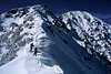
Getting There

From interstate highway 10 exit either on Mountain Blvd. or Euclid Blvd. and travel north. Follow signs towards the Baldy Ski Lifts (aprox 15 miles). For the Bear Canyon/Mt. Baldy Village Trail park on Bear Canyon Road down in Baldy Village (aprox 3 or 4 miles before the lifts). Walk to the end of the road where a sign leads to the trailhead. For the Baldy Notch/Devil's Backbone Trail and the Baldy Bowl/Sierra Club Hut Route park in the dirt pull-outs by Fall's Road at Manker Flat (1/2 mile before the lifts). For the Blue Ridge Trail take highway 38 from intersate 15 towards the town of Wrightwood. Take the Angeles Crest Hywy to the dirt road to Guffy Campground and Prairie Fork. Follow the dirt road 6 miles to a junction and go left. Follow aprox 1.7 miles and park in a pull-out and the base of Pine Mt. (As of 9-3-01 the gate is locked at Guffy Campground.)

Author: banjobonch
Date: Dec 16, 2005 7:06 PM
If coming from the west on Rte -210, exit Baseline Rd. and turn left at the first signal and then right on Padua. Then right on Mt. Baldy Rd. Saves you a couple of miles on the freeway.

Author: R Pollard
Date: Aug 15, 2005 4:48 PM
If you can get to the 210 freeway instead of the 10, you can skip some travel through the city of Upland. Take the exit off of the 210 for Mountain Ave. that says Mountain Ave, Mount Baldy. The directions to the ski lifts at mtbaldy.com have a good map and directions to Mountain Ave.


Red Tape

No wilderness permits are required. A National Forest Adventure Pass is required for your vehicle while parked at any of the trailheads. The pass can be obtained from the ranger station in Baldy Village or in Big Pine (a few miles west of Wrightwood). Many local merchants also sell the pass. The cost is $5.00 a day or $30.00 for an annual pass.

Author: StephaneFitch
Date: Dec 02, 2005 7:48 PM
You can buy a National Forest Adventure Pass at any Big 5 sporting goods store in and around Los Angeles.

Author: displacedcountryboy
Date: Nov 23, 2003 7:17 PM
You do not need an Adventure Pass to park at the Bear Canyon trailhead. Parking along the street outside the Mt Baldy Visitor's Center is free. If you plan to be back by 4.30pm, you can also park in the Visitor's Center parking lot --but beware, they will lock the gates at 4.30pm.


When To Climb

Can be climbed year round.

Camping

Camping is allowed. A free fire permit must be obtained from the Angeles National Forest District for use of camp stoves or camp fires. (626) 335-1251

Mountain Conditions

Angeles National Forest
(626) 335-1251

External Links

Just want to let people know that we've compiled some trip reports and such at the following web-page. We're a college club based in Pasadena, so Mt. Baldy is one of our favorite places to go (mainly for mountaineering and backcountry skiing).
http://www.ugcs.caltech.edu/~alpine/wiki/Mount_Baldy
submitted by Lavaka

Additions and Corrections

[ Post an Addition or Correction ]
Viewing: 1-2 of 2    
greg pattersonUntitled Comment

greg patterson

Hasn't voted

--------------------------------------------------------------------------------


http://www.latimes.com/news/local/la-me-hikers22jan22,1,1003736.story?coll=la-home-local


Hikers Warned to Avoid Icy Risks


Four are dead and two missing in Southland mountains. Despite recent sunshine, 'It's just a sheet of ice up there,' a rescue official says.


By Lance Pugmire and Janet Wilson


Times Staff Writers


January 22, 2004


With four Southland hikers dead since New Year's Day and two more missing, authorities on Wednesday closed a popular Mt. San Gorgonio trail and issued strong warnings to those who choose to hike the region's rugged mountains in treacherous conditions.


"Warning, Extreme Icy Conditions … Do Not Hike Alone," stated fliers handed out with hiking permits in the San Gorgonio district of the San Bernardino National Forest beginning Wednesday. U.S. Forest Service personnel were preparing similar advisories to be given to hikers who buy parking and hiking permits in the San Bernardino, Cleveland, Angeles and Los Padres national forests.


"It's just a sheet of ice up there," said John Amrhein, emergency services coordinator for the San Bernardino County Sheriff's Department. "They're going to slip and fall thousands of feet, like these other hikers, if they're not properly prepared. Basically, now would be a nice time to go to the beach."


Amrhein spoke at the command post at the closed Vivian Creek hiking trailhead, where weary search-and-rescue teams fanned out on a foot of fresh snow atop sheer ice, looking for Eugene Kumm, 25, of Seal Beach, missing since he set out alone for San Gorgonio peak Saturday. He had taken ice climbing equipment he'd been given for Christmas, but had never used it before, authorities said.


Heavy cloud cover at higher elevations meant helicopters had to transport rescuers to narrow ravines. The fresh snow overnight could have covered any tracks or other signs of a campsite, but "if he's still moving, we'd be able to see his footprints clearly," Amrhein said.


By late afternoon, with the sun sinking, the search was suspended for another long, cold night.


Amrhein said searchers had seen "not a thing, not a thing."


To the west, along the Pacific Crest Trail, a second team was searching for Ronald Barbour, 69, of La Crescenta, who set out on a combined bike ride and hike Sunday. Searchers planned to be back out this morning looking for both men.


It has been a grim winter for search-and-rescue teams. Four hikers have been found dead in three weeks, none of them novices. Chung Hun "Charles" Koh, 53, of Buena Park left home New Year's Day to hike on Mt. Baldy. His body was found Saturday, nearly 1,000 feet below a spot where a partner thought he had fallen.


Ali Aminian, 51, of Newbury Park was an experienced Sierra Club member who went hiking alone in the same area Jan. 11, while Koh was still missing. Aminian's body was found Jan. 14.


Matthew L. Jones, 15, of San Bernardino tumbled about 400 feet to his death from a steep, burned slope near Devore on Jan. 11.


Kenneth Smith, 66, of Yucaipa died Jan. 5 while ice climbing in the Forest Falls area, not far from where Barbour is missing now.


Even experienced hikers should understand that winter ice hiking requires Alpine mountaineering equipment and skills, authorities said.


Treacherous ice is the common denominator in three of the four deaths, and the disappearances of Kumm and Barbour, said Sgt. Cliff Weston, the San Bernardino County sheriff's search-and-rescue coordinator. Ice covers trails and slopes frequented by hikers, he said.


"Especially on the north-facing slopes, it has remained extremely cold up there," he said. The high-pressure, bright, sunny weather system in recent weeks has created icy conditions with no snow covering it."


That fair weather in the valleys has fooled too many hikers, Weston said.


"Usually, at this time of year, snowfall would keep people out," Weston said. "Sunshine lulls people into a false sense of security. It may be in the 60s and 70s in the valleys, but it's not warm in the mountains. On the mountaintop, the ice continues to stay, and if hikers continue going up there, we're going to continue to have problems."


The icy conditions are the third deadly threat in the mountains, which were ravaged first by fires, then flash floods late last year. The Old fire, which started in San Bernardino, and the deadly flood that ravaged a campground in Devore were blamed for establishing the brittle ground that gave way when Jones fell to his death.


"The vegetation is not strong in burned areas; more rocks are falling than ever before in those areas. There's a clear message being sent to those who go into the burn areas to be aware of your footing," said Ruth Wenstrom, a U.S. Forest Service spokeswoman.


San Bernardino County authorities have rescued at least six other hikers since Jan. 1. Rescuers typically are called out about 90 times a year, but rarely in such close succession.


Both Mt. Baldy and Mt. San Gorgonio are popular peaks year-round with Southland hikers, and receive snowfall above roughly 7,000 feet in winter. Access to San Gorgonio is regularly limited by use of hiking permits, with 25 to 30 people a day allowed in the area at a time. The Vivian Creek trail is an artery used by hikers to reach the peak. It was closed Wednesday both because of hazardous conditions and because rescuers did not want hikers disturbing any footprints or other clues that might have been left by Kumm.


Authorities urged all hikers to travel with a companion, tell a friend or family member of their exact hiking path, stick to it if at all possible, know the weather forecast, dress warmly and understand that there are many mountainous pockets where cellphones don't work. Hikers going above the snow line should carry ice axes and boot spikes and know how to use them.


While searchers said three of the men who died were experienced hikers, Kumm is better described as an outdoors enthusiast, said Cpl. Darren Goodman of the sheriff's search-and-rescue team.


"He was alone and had no map…. He didn't know the area, and he was in ice with [boot spikes] he just got at Christmas," Goodman said. "Everything he has done indicates he was not an experienced hiker. You don't hike alone. That's suicide."


Dan Hendley, a colleague of Kumm's at Kiewit Industries in Long Beach, said he was surprised to learn that his friend had taken on the 11,500-foot-high mountain by himself.


"He usually goes with his girlfriend or a buddy," said Hendley, who lives across the street from Kumm. "He's a pretty smart dude and a great physical man at 6-2, 240 pounds. But I'm worried about him."


Hendley described his friend as always well-prepared for a hike. He said Kumm had hiked to 6,500 feet a week earlier with his girlfriend. And he said he doesn't have any doubt that his friend is still alive.


"I'm assuming, with all the snow, he just got turned around," Henley said. "If he's not hurt, he's on the move somewhere. He's a pretty strong-willed guy."


*


--------------------------------------------------------------------------------


Times staff writer Dave McKibben contributed to this report.


Posted Jan 22, 2004 4:09 pm
Cookie AddictUntitled Comment

Cookie Addict

Hasn't voted

It seems that the sign that points out the Ski Hut Trail keeps going missing and the trail is easy to miss for first timers. Walk to the Falls and follow the pot-holed "paved" road up and back to the right. After about 3/10 of a mile the road makes a left turn and has a slight down grade. From that turn, the trail to the Sierra Club hut is about 30 yards down on the left. It looks like a goat trail rising sharply into talus and broken sedimentary outcrops. You will know you are on the right track is after going up for about five minutes you run into a brown steel trail log box.
Posted Feb 6, 2006 12:30 am

Viewing: 1-2 of 2    

Images